Israeli archaeologists find 3,000-Year-old ‘Biblical royal purple dye’

Israeli archaeologists find 3,000-Year-old ‘Biblical royal purple dye’

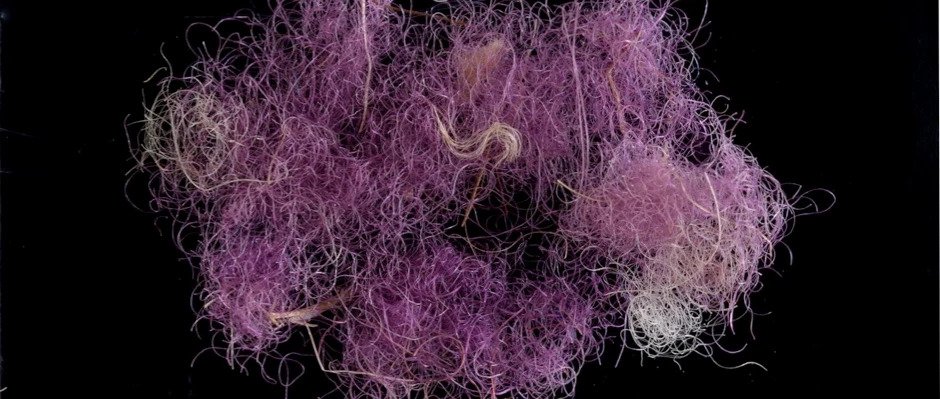
In Israel, fragments of dyed thread uncovered dating back 3,000 years refer to the accounts in the Bible of the purple garments worn by royalty including King Solomon. Researchers from Israel find traces of woven fabric, a tassel,  and fibers of wool dyed in so-called ‘royal purple’ from a dig site in the Timna Valley.

The area is rich in copper ore in the country’s south and has been mined since the 5th millennium BC. It belonged to Edom, the biblical kingdom. The discovery is the first time that purple cloth from about 1,000 BC has been discovered and represents a glimpse into the Biblical Kings’ wardrobes.

Purple dye was coveted for its vibrant colour and longevity — but its origins, being sourced in minute amounts from shellfish — made it expensive to use.

Israeli archaeologists find 3,000-Year-old 'Biblical royal purple dye'
Scraps of dyed thread (pictured) unearthed in Israel that date back 3,000 years match the descriptions of the purple garments worn by royalty like King Solomon in the Bible

‘This is a very exciting and important discovery,’ said the Israel Antiquities Authority’s curator of organic finds, Naama Sukenik. This is the first piece of textile ever found from the time of David and Solomon that is dyed with the prestigious purple dye.’

‘In antiquity, purple attire was associated with the nobility, with priests, and of course with royalty.’ Direct radiocarbon dating has confirmed that the finds date from around 1,000 BC, matching the times of the biblical monarchies of David and Solomon in Jerusalem.

In the Old Testament, the colour is mentioned in the ‘Song of Songs’, chapter 3, verses 9–10.

‘King Solomon made for himself the carriage; he made it of wood from Lebanon,’ the scripture reads. Its posts he made of silver, its base of gold. Its seat was upholstered with purple, its interior inlaid with love.’

Royal purple dye — made from molluscs found in the Mediterranean, over 186 miles (300 km) north of Timna — is described in various Jewish and Christian texts. However, this is the first time that purple-dyed Iron Age textiles have actually been found in Israel — or, indeed, anywhere throughout the Southern Levant.

‘The gorgeous shade of the purple, the fact that it does not fade, and the difficulty in producing the dye — which is found in minute quantities in the body of molluscs — all made it the most highly valued of the dyes,’ explained Dr Sukenik. The dye, he continued, often cost more than the equivalent amount of gold.

‘Until the current discovery, we had only encountered mollusc-shell waste and potsherds with patches of dye, which provided evidence of the purple industry in the Iron Age.’

‘Now, for the first time, we have direct evidence of the dyed fabrics themselves, preserved for some 3000 years.’

Other organic materials — including Iron Age textiles, cords and leather — were also preserved at the Timna site thanks to the region’s extremely dry climate. These artefacts — which also date back to the time of David and Solomon — offer a unique glimpse into life during biblical times, the researchers said.

Researchers from Israel found remnants of woven fabric (pictured), a tassel and fibres of wool dyed in so-called ‘royal purple’ from a dig site in the Timna Valley

‘Our archaeological expedition has been excavating continuously at Timna since 2013,’ said Erez Ben-Yosef of Israel’s Tel Aviv University. If we excavated for another hundred years in Jerusalem, we would not discover textiles from 3,000 years ago.’

‘The state of preservation at Timna is exceptional and it is paralleled only by that at much later sites — such as Masada and the Judean Desert Caves.’

In recent years, the archaeologists have been excavating a relatively new site in the region, which is referred to as ‘Slaves’ Hill’.

‘The name may be misleading since, far from being slaves, the labourers were highly skilled metalworkers,’ added Professor Ben-Yosef. Timna was a production center for copper, the Iron Age equivalent of modern-day oil,’ the archaeologist continued.

‘Copper smelting required advanced metallurgical understanding that was a guarded secret and those who held this knowledge were the “hi-tech” experts of the time,’ he said.

‘Slaves Hill is the largest copper-smelting site in the valley and it is filled with piles of industrial waste such as slag from the smelting furnaces,’ said Professor Ben-Yosef.

‘One of these heaps yielded three scraps of coloured cloth. The colour immediately attracted our attention, but we found it hard to believe that we had found true purple from such an ancient period’.

According to the researchers, the purple dye — thought to have been called argaman in Hebrew — was produced from three species of mollusc that are indigenous to the Mediterranean Sea.

These species included the Banded Dye-Murex, the Spiny Dye-Murex and the Red-Mouthed Rock-Shell. The dye was made from a gland inside the body of the mollusc via a complex chemical process that lasted several days.

Argaman (purple) and tekhelet (azure) colours are often mentioned together in ancient texts and still have symbolic value and religious significance to this day. Temple priests, the Kings David and Solomon (pictured), and also Jesus of Nazareth are described as having worn purple

Today, most experts agree that two different precious dyes — the purple argaman and the light blue, or azure, tekhelet — were both produced from the purple dye molluscs, but using different levels of exposure to light.

These two colours are often mentioned together in ancient texts and still have symbolic value and religious significance to this day. Temple priests, the Kings David and Solomon and also Jesus of Nazareth are described as having worn purple-coloured clothing.

To reconstruct the mollusc dyeing process, Professor Amar travelled to Italy where he cracked open thousands of molluscs to extract raw material from their innards. This was then used in hundreds of attempts to reconstruct the ancient dye.

The Timna Valley — in the country’s south — is rich in copper ore and has been mined since the 5th millennium BC. It belonged to the biblical Kingdom of Edom.

Golden Eagle Sculpture Unearthed in Aztec Temple

Golden Eagle Sculpture Unearthed in Aztec Temple

According to a statement released by Mexico’s National Institute of Anthropology and History (INAH), archaeologists led by Rodolfo Aguilar Tapia have uncovered a bas-relief sculpture of a golden eagle in the floor of the Aztec chapel dedicated to Huitzilopochtli at the Templo Mayor.

The well-preserved floor surface was covered during an expansion of the temple before the arrival of the Spanish in Tenochtitlan in the sixteenth century, Tapia explained.

“From what we have seen through photographs, it is a very beautiful piece that shows the great secrets that the Templo Mayor of Mexico Tenochtitlan has yet to reveal to us. I want to extend my appreciation to the INAH archaeologists who collaborate in this space, since, thanks to their effort and dedication, we can continue to recover our history and our memory.

Due to the health contingency, the fieldwork has had to be postponed, however, it is clear that there is also an important work of research and academic reflection that has not stopped “, said the Secretary of Culture, Alejandra Frausto Guerrero, about this notable finding.

Although it was in February 2020 when a multidisciplinary team concluded the release and cleaning of this itzcuauhtli , a Nahua voice that means “obsidian eagle”, and with which the Mexica referred to the golden eagle ( Aquila chrysaetos canadensis ), it is now, when his investigation in the cabinet has been deepened, the finding is made known.

Carved on red tezontle and with dimensions of 1.06 meters long by 70 centimetres wide, this bas-relief is the largest in a set of 67 similar elements found so far in the Templo Mayor.

According to specialists, the relevance of the sculpture is denoted not only by its size and finish but also by its location, at the foot of the most important building for the Mexica and in the central axis that crosses the ‘chapel’ of Huitzilopochtli and the monumental sculpture of the goddess Coyolxauhqui. It is also close to Cuauhxicalco, a circular building whose name translates as “place of the eagle’s gourd”, where, according to 16th-century documents, the ritual cremations of the Tenochca rulers were carried out.

Golden Eagle Sculpture Unearthed in Aztec Temple
At 1.06 meters long and 70 centimeters wide, it is the largest of the set of similar sculptural pieces found so far. It was located at the foot of the Templo Mayor, in the central axis of the ‘chapel’ dedicated to Huitzilopochtli; would correspond to the government of Motecuhzoma Ilhuicamina (1440-1469 AD)

Regarding the discovery of the bas-relief, the archaeologist assigned to the PTM, Rodolfo Aguilar Tapia, who investigated the piece together with the interns in archaeology Mary Laidy Hernández Ramírez and Karina López Hernández; and in physical anthropology, Jacqueline Castro Irineo, from the National School of Anthropology and History, reported that it was verified during the ninth field season of the PTM.

This season, directed by the head of the Project, the archaeologist Leonardo López Luján, has focused on exploring under the ‘liga bridge’ that connects the streets of Guatemala and Argentina, wherein pre-Hispanic times the west plaza of the Sacred Precinct was located of Mexico-Tenochtitlan. The sculptural carving was part of a floor of that space, which would have been in use during the government of Motecuhzoma Ilhuicamina, between the years 1440 and 1469 of our era.

“This floor is unique in the entire Templo Mayor as it contains bas-reliefs that allude to the dual conception of the building. On the south side, where we are exploring, there are elements like this eagle, linked to the mythical cycle of the birth of Huitzilopochtli; while to the north, the bas-reliefs located earlier —the first in 1900 by Leopoldo Batres, and the later by the PTM and the Urban Archeology Program (PAU) – contain representations associated with Tláloc, the water cycle and the regeneration of corn “.

Aguilar Tapia specifies that thanks to the work carried out by archaeologists Eduardo Matos Moctezuma and Leonardo López Luján, today there is a defined stratigraphic correspondence, which allows researchers to know in which construction stage of the Templo Mayor the findings are located, and at what time belong the same.

Thus, he exemplifies, when the exploration at the aforementioned intersection began, the floor that the archaeologists saw was from Stage VI of the Templo Mayor, corresponding to the government of Ahuítzotl between 1486 and 1502, while now, after meticulous excavations, specialists have managed to reach Stage IV-a, that is, they have gone back in time to the 1440s and to the period of government of Motecuhzoma I.

The aforementioned plaza floor was covered since pre-Hispanic times during the expansion of the Templo Mayor. “That is why it has a good state of conservation,” says the researcher, noting that “it is an element that was never seen by the Spanish.”

The symbolism of the golden eagle

The pause in the fieldwork that the COVID-19 pandemic brought with it, allowed the PTM researchers to carry out the investigation of various elements, including the bas-relief. Among other aspects, the iconographic representations that exist of the golden eagle in historical sources such as the codices were studied, in order to correlate them with the sculpture discovered at the foot of the Templo Mayor.

One of those representations, Aguilar Tapia points out, is in Plate 50 of the Codex Borgia, where a golden eagle is shown posing on top of a mesquite tree, a tree that rises from a stark deity. “The interesting thing is that this image is iconographically very similar to the bas-relief that we find in the field, in both representations the feathers end in the shape of sacrificial knives, which allude to the Nahua name of the bird: obsidian eagle.”

For the Mexica, this bird of prey was closely related to war and sacrifice, while it was considered a nahual of the sun and, therefore, also of its tutelary god, Huitzilopochtli.

In the incoming seasons of the PTM field, the researcher concludes, the actions will focus on completing the exploration of the floor where the bas-relief is located to look for more others and then, with extreme care, temporarily remove them and be able to investigate under them in search of offerings or other architectural elements. “After all this exploratory process, with the support of restoration specialists, we will place each bas-relief in its precise place”, he concludes.

Similar elements could also be found when the excavations around Cuauhxicalco are resumed. The intention of the PTM is that, after its investigation, the bas-reliefs can be shown to the public in their original position: at the west foot of the Templo Mayor.

Russian Divers Discover Ancient Roman Sea Fortress at Tartus

Russian Divers Discover Ancient Roman Sea Fortress at Tartus

According to an announcement by Dmitry Tatarkov, director of the Centre for Maritime Science and Technology at Russia’s Sevastopol State University, an ancient port claimed to date back to the Roman period has been discovered off the Syrian coast of Tartus (SSU).

“It may not have even been a port, but it is a sea fortress from the 1st century AD. Remains of hydraulic structures, a lighthouse, and four marble columns have been found.

Accompanying ceramic materials will allow for a more detailed dating of the piece. This is a major finding,” said Tatarkov.

Russian Divers Discover Ancient Roman Sea Fortress at Tartus
Underwater divers have discovered naval structures, an ancient port and a Roman sea fortress off the coast of Syria at Tartus.
More remains of the structures.
Scientists from Sevastopol State University discover the ruins of an ancient Roman port in the Syrian waters of Tartus. They are believed to be the remains of the ancient defensive walls of Arvard Island

“These are the remains of ancient Greek amphorae, Phoenician pots, Egyptian vases, and household items made of Roman stone.

These materials will allow us to rebuild the maritime trade routes linking this region with the major Mediterranean regions. We will be able to determine the life cycle of the ports that existed at the time,” he explained.

The ruins are thought to belong to the ancient Arvad Island which was originally settled by the Phoenicians in the early 2nd millennium BC.

They were found during the second field season by a Russian-Syrian archaeological mission launched in 2019 by SSU with the support of Russia’s Ministry of Defence and the Institute of Oriental Studies of the Russian Academy Sciences.

The expedition was carried out as part of an agreement between the university and Syria’s Ministry of Culture and includes both Russian and Syrian specialists.

According to the Russian university’s website, one of the objectives of the expedition will be the advanced training of Syrian specialists and students from Damascus University and the University of Latakia.

This Yellow Egyptian Glass Was Forged by a Meteorite Impact 29 Million Years Ago

This Yellow Egyptian Glass Was Forged by a Meteorite Impact 29 Million Years Ago

In 1922, British archaeologist Howard Carter discovered the untouched tomb of Tutankhamen, a minor pharaoh who ruled over Egypt almost 3,300 years ago. When Carter entered the tomb for the very first time and asked if he could see anything, he famously responded: ”Yes, wonderful things.” Tutankhamen’s burial chambers were filled with statues made of ivory, items made of gold and precious jewellery.

In a treasure chest, Carter discovered a large pectoral, a breastplate decorated with gold, silver, various precious jewels and a strange gemstone, that the pharao wears across his chest. The breastplate shows the god Ra as a winged scarab, made from a yellow-green gemstone, carrying the celestial bark with the Sun and the Moon into the sky.

Carter identified the gemstone at first as chalcedony, a common variety of the mineral quartz. In 1932 the British geographer Patrick Clayton was exploring the Great Sand Sea along the border of modern Egypt and Libya. Here he discovered some strange pieces of glass in the sand.

This Yellow Egyptian Glass Was Forged by a Meteorite Impact 29 Million Years Ago
Tutankhamun’s breastplate features a scarab carved from Libyan Desert Silica Glass
King Tut’s tomb included an artifact called a pectoral, which incorporated a piece of Libyan Desert Glass as the scarab beetle at its center.

The yellow-green material seemed to be identical to the gemstone found in Tutankhamen’s tomb. Two years later he published a short note, suggesting that the pieces of glass were the quartz-rich deposits of a completely dried up lake.

In 1998, Italian mineralogist Vincenzo de Michele analyzed the optical properties of the gemstone in King Tut’s breastplate and confirmed that it was indeed a piece of Libyan Desert Silica Glass, as the material is nowadays called. Libyan Desert Glass consists of almost pure silicon dioxide, like quartz, but its crystal structure is different. 

It also contains traces of unusual elements, like iron, nickel, chromium, cobalt and iridium. It is among the rarest minerals on Earth, as it is found only in the Great Sand Sea north of the Gilf Kebir Plateau, one of the most remote and desolate areas in the Libyan Desert.

Piece of Lybian Desert Glass.

The origin of the desert glass has long remained a mystery. Glass forms naturally when molten rock material cools so rapidly that atoms are unable to arrange themselves into a crystalline structure. 

Obsidian is a natural glass that forms when lava from a volcano rapidly cools and solidifies. However, no extinct volcano can be found near the site where the desert glass occurs. Tektites are natural glass formed when the debris of a meteorite impact is ejected high into Earth’s atmosphere, where the molten debris will rapidly cool and solidify into glass spherules. 

Tektites have been found across Asia, Australia and as far away as Antarctica. However, no impact crater associated with the desert glass is known in the Libyan Desert. In an alternative scenario proposed in 2013 a comet, composed mostly of ice, entering Earth’s atmosphere may have exploded mid-air above the desert.

The generated heat burst, an estimated 2,000°C, would be sufficient to melt the upper layers of the sand dunes, forming the desert glass, but without leaving a crater behind.

A new study published in the journal Geology refutes this scenario, claiming that an airburst alone wouldn’t be sufficient to explain the formation of the desert glass. The researchers analyzed grains of the mineral zircon found in the desert glass, discovering that the supposed zircon grains are actually a very rare mineral called reidite.

Reidite is chemically similar to zircon, however, displays a different, denser crystalline structure. Reidite forms only under very high pressure, es experienced during massive meteorite impacts. Reidite can’t form by the low pressure of an airburst. Airbursts, as the researchers argue, create shock waves in Earth’s atmosphere with pressures of some thousands of pascals.

During a meteorite impact, the shock waves in the ground can reach some billions of pascals, millions of times more powerful than any airburst. Only a meteorite impact on the ground, generating enough pressure to form the reidite and enough heat to melt the sand, can explain the stray field of desert glass fragments found in the Lybian Desert.

However, it remains unclear where the impact crater associated with the Lybian Desert Glass is located, even if radiometric dating suggests that the impact happened around 28 to 26 million years ago.

It’s also unclear how the desert glass became part of Tutankhamen’s treasures. Archaeological evidence suggests that an ancient system of caravan routes existed around the Gilf Kebir Plateau, but it doesn’t seem that the routes were used to search or trade for the desert glass.

It seems that the piece used for the scarab was discovered by chance or maybe an exotic gift. It remains the only known example where an Egyptian artist used this mysterious material.

Priests Discover Golden Library Built by Giants Inside of a Cave in Ecuador?

Priests Discover Golden Library Built by Giants Inside of a Cave in Ecuador?

About two years ago we brought up the fact that in Ecuador a priest made one of the most incredible discoveries of the 21st century, to say the least. But because it didn’t get all that much attention, we figured it’d be about time we give it some more exposure.

So, the discovery was made by a man that goes by the name of Crespi.

He’s been working as a priest for most of his life now and despite the fact that he’s never been all that much of a believer in the extraterrestrial factor he couldn’t help but think about it as he saw the discovery with his own two eyes.

So, what exactly did he see? He stumbled across a massive metallic alien library which was packed full of sheets of gold, platinum, and other such precious metals.

Inside he also uncovered several artefacts that became known as Cueva de Los Tayos.

Priests Discover Golden Library Built by Giants Inside of a Cave in Ecuador

The Ecuadorian authorities wouldn’t confirm the existence of any of them, but the proof is definitely out there ready to be explored by anyone who’s willing to look for it.

Photograph of Father Crespi with some local children

It is said that many important individuals including Neil Armstrong himself visited the cave on multiple occasions to essentially discover the true origin of all of humanity.

The caves are said to go on forever and ever, to the point where it becomes impossible to read every book in the library within the span of one’s lifetime.

Fact Check & Truth

IN 1976, A MAJOR EXPEDITION entered the Cueva de Los Tayos in search of artificial tunnels, lost gold, strange sculptures, and a “metallic library,” supposedly left by a lost civilization aided by extraterrestrials. Among the group was the astronaut Neil Armstrong.

For as long as anyone can remember, the indigenous Shuar people of Ecuador have been entering a vast cave system on the jungle-covered eastern foothills of the Andes. They descend, using ladders made of vines, through one of three vertiginous entrances, the largest of which is a 213-foot-deep (65-meter) shaft that leads into a network of tunnels and chambers stretching, as far as we know, for at least 2.85 miles. The largest chamber measures 295 feet by 787 feet.

For the Shuar, these caves have long been a centre for spiritual and ceremonial practices, home to powerful spirits as well as tarantulas, scorpions, spiders, and rainbow boas. They are also home to nocturnal oilbirds, known locally as tayos, hence the name of the cave. The tayos are a favoured food of the Shuar, another reason why they brave the depths of the cave system.

In their role as guardians of the cave system, the Shuar had been left in relative peace over the last century or two, apart from an occasional gold prospector snooping around in the 1950s and ‘60s. Until that was, a certain Erich von Däniken decided to get involved.

The Swiss author captured the global imagination in 1968 with the publication of his book Chariots of the Gods? which was in large part responsible for the current plague of ancient astronaut theories and all that malarkey. Then, three years later, he published The Gold of the Gods, unleashing a little-known theory about the Cueva de Los Tayos upon his eager readership.

In The Gold of the Gods, von Däniken recounted the claims of János Juan Móricz, an explorer who claimed to have entered the caves in 1969. Inside the cave, he asserted, he had discovered a treasure trove of gold, strange artefacts and sculptures, and a “metallic library” containing lost information preserved on metal tablets. And the caves themselves were surely artificial, he claimed, created by some advanced intelligence now lost to history.

This was red meat for von Däniken, of course, and tied in very nicely with his spate of lucrative books promoting his theories of lost civilizations, ancient astronauts, and the like (or, as Carl Sagan put it, von Däniken’s theory that “our ancestors were dummies”).

It also inspired the first major scientific expedition to Cueva de Los Tayos. The 1976 expedition was led by Stan Hall, a Scottish civil engineer who had read von Däniken’s work. It quickly grew to become one of the largest cave expeditions of its time, with more than 100 people involved. These included British and Ecuadorian government officials, leading scientists and speleologists, British special forces, professional cavers, and none other than astronaut Neil Armstrong, who served as the expedition’s Honorary President.

The expedition was a success, at least in its less fanciful ambitions. The extensive network of caves was mapped far more thoroughly than ever before. Zoological and botanical findings were recorded. And archaeological discoveries were made. But no gold was found, no otherworldly artefacts discovered, and there was no sign of a metallic library. The cave system, too, appeared to be the result of natural forces rather than any kind of advanced engineering.

Interest in the Cueva de Los Tayos never again reached the heights of the 1976 expedition, but numerous research expeditions have since taken place. One of the more recent expeditions was that of Josh Gates and his team for the fourth season of the television series Expedition Unknown. Gates entered the cave system with Shuar guides and Eileen Hall, the daughter of the late Stan Hall from the 1976 expedition. And while expeditions such as these have resulted in fascinating zoological and geological discoveries, there’s still no sign of gold, aliens, or a library.

‘Britain’s Atlantis’ found at bottom of North sea – a huge undersea world swallowed by the sea in 7000BC

‘Britain’s Atlantis’ found at bottom of North sea – a huge undersea world swallowed by the sea in 7000BC

Doggerland was a region of land that connected Great Britain to mainland Europe before and during the last Ice Age. It was then gradually flooded by rising sea levels around 6,500–6,200 BCE. Geological surveys have suggested that it stretched from Britain’s east coast to the Netherlands and the western coasts of Germany and the peninsula of Jutland.

In the Mesolithic period, it was possibly a rich human habitat, but rising sea levels eventually reduced it to low-lying islands until its final destruction, perhaps following a tsunami caused by the Storegga Slide.

The archaeological potential of the area had first been discussed in the early 20th century, but interest intensified in 1931 when a commercial trawler operating between the sandbanks and shipping hazards of the Leman Bank and Ower Bank east of Wash dragged up a barbed antler point that dated to a time when the area was tundra. Vessels have dragged up remains of a mammoth, lion and other land animals, and small numbers of prehistoric tools and weapons.

A woolly mammoth skull discovered by fishermen in the North Sea, at Celtic and Prehistoric Museum, Ireland Author Omigos.

British scientists and researchers have recently started using 4D technology to explore the remains of an area inhabited before sea levels destroyed it over 7,000 years ago.  Historians believe that the area spanned over 100,000 square miles and was home to dozens of prehistoric Britons. 

It was once known as Doggerland.  Using 4D technology, researchers will show how Doggerland was colonized and inhabited before being washed away.  The researchers like to call this area “Britain’s Atlantis”.

Over the years, experts from Bradford and Nottingham have worked on the multi-million pound 4D project.  With the tool, they hope to find evidence of flint tools, animal DNA, and pollen from plants.  One of the researchers working on the project, Mr. Vince Gaffney, says that he hopes the 4D tool will find something so other researchers can use the information.

Historians believe that Doggerland was submerged sometime between the years of 18,000 and 5,500 BC. 

The area was just recently found by divers in the area; they were doing research three years ago to find more oil resources when they discovered the remains of the other world.

Some historians believe that this area could have been home to thousands of people and was most likely once the heartland of Europe. After the divers’ discovery, climatologists, archaeologists, and geophysicists mapped the area and found out this Atlantis stretched from Denmark to Scotland.

This could be a leftover from Doggerland

Until the middle Pleistocene, Britain was a peninsula of Europe, connected by a massive chalk anticline, the Weald–Artois Anticline across the Straits of Dover. During the Anglian glaciation, approximately 450,000 years ago, an ice sheet filled much of the North Sea, with a large proglacial lake in the southern part fed by the Rhine, Scheldt, and Thames river systems.

The catastrophic overflow of this lake carved a channel through the anticline, leading to the formation of the Channel River, which carried the combined Scheldt and Thames rivers into the Atlantic. It probably created the potential for Britain to become isolated from the continent during periods of high sea level, although some scientists argue that the final break did not occur until a second ice-dammed lake overflowed during the MIS8 or MIS6 glaciations, around 340,000 or 240,000 years ago.

Map showing the hypothetical extent of Doggerland (c. 8,000 BC), which provided a land bridge between Great Britain and continental Europe. – Max Naylor

During the most recent glaciation, the Last Glacial Maximum that ended in this area around 18,000 years ago, the North Sea and almost all of the British Isles were covered with glacial ice and the sea level was about 120 m (390 ft) lower than it is today.

After that, the climate became warmer and during the Late Glacial Maximum much of the North Sea and the English Channel was an expanse of low-lying tundra, around 12,000 BC extending to the modern northern point of Scotland

With the new technology, there is now research on two more North Sea valleys being led by Mr. Gaffney.  The project is funded by a European grant.

Mr. Gaffney and his team hope to use remote sensing data to reconstruct the ancient landscape.  Besides this research, the team hopes to get some core sediment samples from the landscape to eventually create a map showing rivers, lakes, hills, and coastlines.

After the area slowly started sinking into the water, a storm surged and the sea levels rose abruptly, creating an island around 6,500 BC.  One thousand years after the first storm, the whole island was then submerged and lost.

The team hopes to learn more about the lifestyles of the territories.  One researcher from Wales says that the project will let the team look into the ways of the people and also what it was like to live in the Mesolithic period. 

The new 4D technology will open up new doors for researchers and historians to find out more about territories, colonies, and people from thousands of years in the past.

Village Dated to First Bulgarian Empire Discovered

Village Dated to First Bulgarian Empire Discovered

A previously unknown village dated to the ninth century A.D. was discovered in northeastern Bulgaria by a team of researchers led by Stanislav Ivanov of the Shumen Branch of Bulgaria’s National Institute and Museum of Archaeology in Sofia, according to an Archaeology in Bulgaria report.

The 9th century AD was a very turbulent time for the First Bulgarian Empire but also a prelude to its greatest rise, with its so-called Golden Age beginning in the second half of the century and lasting into the middle of the 10th century.

For the First Bulgarian Empire, the 9th century started with the rule of Khan Krum the Fearsome (r. 803 – 814 AD), and ended with the beginning of Tsar Simeon I the Great (r. 893 – 927 AD). It saw the conversion of the entire Bulgarian Empire from paganism to Christianity and the development and adoption of the Bulgaric (Cyrillic) alphabet under Knyaz Boris I (r. 852 – 889; 893 AD) ushering into the rise of the Old Bulgarian literary language.

The previously unknown medieval Bulgarian village has been discovered as a result of rescue excavations for the construction of the Hemus Highway, a road linking the Bulgarian capital Sofia with the city of Varna on the Black Sea via the Danube Valley in Northern Bulgaria.

An archaeological team led by Stanislav Ivanov from the Shumen Branch of the National Institute and Museum of Archaeology in Sofia explored the archaeological site of the 9th-century Bulgarian village in September 2020. More than 100 people, including 16 archaeologists, took part in the rescue excavations, BTA reports.

The site in question is located near today’s town of Gradishte, Shumen District, in Northeast Bulgaria. (“Gradishte” is an old Bulgarian word referring to a “fortress” or a “stronghold”.)

Dozens of dugouts typical of the rural population of the First Bulgarian Empire in the 9th century AD have been unearthed in a medieval settlement in the Shumen District.

The archaeological team has unearthed about 17 decares (app. 4 acres) from the territory of the medieval Bulgarian settlement as part of the plot slated for rescue digs for the building of the Hemus Highway. They have dug up some 80 dugout dwellings, with the total territory and the total number of 9th-century homes in the village remaining unknown for the time being.

Dozens of dugouts typical of the rural population of the First Bulgarian Empire in the 9th century AD have been unearthed in a medieval settlement in the Shumen District.

“At the present stage, we are unable to say how big the settlement was,” lead archaeologist Stanislav Ivanov is quoted as saying.

“The bulk of the archaeological site is a settlement from the First Bulgarian State. These are dugout dwelling which was typical for the population that was not of aristocratic origin. These are dug into the ground, dugouts of the classical type, which have also been studied in other sites as well,” Ivanov explains.

“We have detected about 80 dwellings so far. On the inside, they had wooden plaster which has not survived. However, in many cases, there was a filling between the plaster and the soil, which has been preserved. It was used as additional reinforcement of the very walls of the dwellings,” the archaeologist elaborates.

“In some sectors of the settlement, we observe the grouping of dwellings. It is unclear why that is. It may have been due to individual families, or due to random factors, or due to the fact that some of the dwellings were slightly earlier than the others,” he adds.

“We will have a clearer idea about that after the processing of all materials. That will tell us which dugouts were built earlier and which came later. There are cases of dwellings which were reused, up to three times, as indicated by the floor levels and other evidence,” Ivanov says.

In some of the dugouts from the 9th-century village from the time of the First Bulgarian Empire, the archaeologists have discovered kilns used for the making of household pottery items.

The excavations have yielded also numerous arrow tips. Ivanov cautions, however, that the village was hardly the site of a battle. Instead, the arrow tip finds demonstrate that the male population of the medieval Bulgarian settlement included numerous warriors.

The dozens of dugouts have yielded other artifacts such as knives, bone awls, and here and there some adornments, bronze rings being the most frequent ones, and some medallions. The researchers hypothesize that one medallion, in particular, may have been used as an amulet against curses.

“So far we have found no evidence of crafts and the production of artifacts,” Ivanov says.

For the time being, the archaeologists have discovered neither the necropolis of the 9th-century medieval Bulgarian village nor any commercial or storage facilities. However, they do not rule the possibility of coming across those, with further excavations expected to be conducted in the 2021 archaeological season.

A map showing the First Bulgarian Empire in the 9th and 10th century AD.
A map showing the culture of the First Bulgarian Empire.

During the rescue digs at the site near Gradishte in Northeast Bulgaria along the route of the Hemus Highway, the archaeologists have also found in deeper layers some prehistoric items from the Chalcolithic (Aeneolithic, Copper Age). Their presence is due to a nearby Chalcolithic settlement mound.

A large number of dugouts, some of them quite untypical in size and containing stone structures, have also been found during rescue excavations in 2020 in what was a previously unknown town from the 8th – 10th century right outside of Pliska, the first capital of the First Bulgarian Empire.

ANCIENT EROTICA Pornographic Pompeii wall paintings reveal the raunchy services offered in ancient Roman brothels 2,000 years ago

ANCIENT EROTICA Pornographic Pompeii wall paintings reveal the raunchy services offered in ancient Roman brothels 2,000 years ago

The amorous activities of ancient Italians have been revealed by wall paintings in a historical Pompeii brothel. The ‘Lupanar of Pompeii.’ are decorated with Centuries-old wall paintings showing explicit sex scenes.

ANCIENT EROTICA Pornographic Pompeii wall paintings reveal the raunchy services offered in ancient Roman brothels 2,000 years ago
Wall paintings in a historic Pompeii brothel have revealed the amorous activities of ancient Italians. The ‘Lupanar of Pompeii’ is decorated with centuries-old wall paintings depicting explicit sex scenes

Before the Roman city was famously wiped out by a volcanic eruption in 79 AD, the sex house was once a hangout for wealthy businessmen and politicians. Researchers claim the services offered by prostitutes may have been suggested by the erotic paintings showing group sex and other acts. These services and ventures still happen to this day all over the globe, however, with the invention of the internet it can be much easier to find a willing female on a website similar to https://www.escortdirectory.com/escorts-munich-199 to exchange sexual acts for money. It’s surprising to see this happened in some form 2,000 years back, and even more surprising that they kept paintings of their numerous sexual acts. It is a far cry from the world we live in today, where many of us know how to unblock XNXX and other adult sites, but it also shows that our enjoyment of adult entertainment hasn’t changed.

The Lupanar of Pompeii was the centre point for the doomed city’s thriving red-light district. The ancient Roman brothel was originally discovered in the nineteenth century. It was closed but was recently re-opened to the public in October 2006.

While the brothel is neither the most luxurious nor the most important historic building in what remains of Pompeii, it is the most frequently visited by tourists from across the world. Perhaps it inspires a night or two with a pocket pussy or other toys after a visit..

Prostitutes at the brothel were not exclusively women. Men, especially young former slaves, sold themselves there too – to both men and women. The erotic lives of Pompeii’s prostitutes were recently illustrated by Western University professor, Kelly Olson.

Mural from a Pompeii brothel.

Professor Olson focuses her work on the role of women in Roman society, and the apparent open sexuality visible in the many frescos and sculptures.

The Classical Studies professor travelled to the ancient city last month as a featured expert on Canadian broadcaster CBC’s programme ‘The Nature of Things’.

Speaking of life in ancient Pompeii brothels, she said: ‘It’s not a very nice place to work.’ ‘It’s very small, dank and the rooms are rather dark and uncomfortable,’ she told CBC.

‘Married men could sleep with anyone as long as they kept their hands off other men’s wives,’ she said. ‘Married women were not supposed to have sex with anyone else.’

The building is located in Pompeii’s oldest district. The two side streets that line the brothel were once dotted with taverns and inns.

The ancient Roman brothel was originally discovered in the nineteenth century. It was closed but was recently re-opened to the public in October 2006

Upon entering the building, visitors are met by striking murals of erotic scenes painted on the walls and ceilings. In each of the paintings, couples engage in different sexual acts.

According to historians, the paintings weren’t merely for decoration – they were catalogues detailing the speciality of the prostitute in each room. Two thousand years ago, before the devastating volcanic eruption, prostitution was legal in the Roman city.

Slaves of both sexes, many imported from Greece and other countries under Roman rule, were the primary workforce. The Unesco World Heritage Site is of special importance because, unlike other Pompeii brothels at the time, the Lupanar of Pompeii was built exclusively for prostitution appointments, serving no alternative function.

Its walls remain scarred by inscriptions left by past customers and working girls. Researchers have managed to identify 120 carved phrases, including the names of customers and employees who died almost two thousand years ago.

Researchers believe the erotic paintings depicting group sex and other naughty acts may have indicated the services offered by prostitutes

Many of these inscriptions include similar phrases to those ones would find in a modern-day bathroom, including men boasting of their sexual prowess.

On the top floor of the building sit five rooms, each with a balcony from which the working girls would call to potential customers on the street.

Much like in ancient Rome, researchers speculate that Pompeii prostitutes were required to legally register for a licence, pay taxes, and follow separate rules to regular Pompeii women.

For example: When out on the street, Pompeii’s working girls wore strict attire – they wore a reddish-brown coat at all times, and dyed their hair blonde. Prostitutes were separated into different classes depending on where they worked and the customers they served.

Though the historic sex site has been “closed for business” for some time, that hasn’t stopped some raunchy holidaymakers attempting to re-christen the building. In 2014, three French holidaymakers were arrested for trespassing after breaking into the brothel ruins for a late-night sex romp.

Pompeii was an ancient Roman city located near modern Naples, in the Campania region of Italy

A Frenchman and two Italian women, all aged 23 to 27, allegedly broke into the Suburban Baths to fulfil their fantasies inside a former brothel that is still decorated with centuries-old wall paintings depicting explicit sex scenes.

But authorities brought the group’s middle-of-the-night threesome to a premature end.

All In One Magazine