Fort, Church, and Temple Remains Uncovered in Southern Egypt
Egypt Today reports that researchers from Egypt’s Supreme Council of Antiquities have discovered traces of a temple dated to the Ptolemaic dynasty, a Roman fort, and part of a Coptic-period Christian church at the Shiha Fort site in southern Egypt.
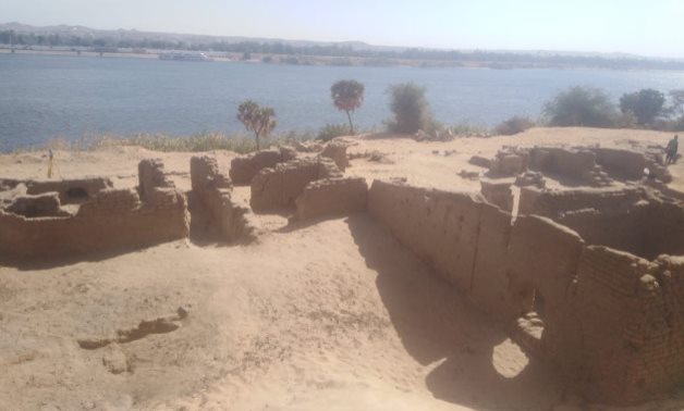
Remains of Aswan Roman Fort
The Supreme Council of Antiquities’ Egyptian archaeological mission, operating at the Shiha fort site in Aswan Governorate, has recently discovered the remains of a Roman fort that includes the remains of a church from the early Coptic era, and the remains of a temple from the Ptolemaic period.
Inside the fort, a group of architectural elements of the Ptolemaic temple were discovered; an incomplete sandstone panel, with a model of the temple entrance and a man in the form of a Roman emperor standing next to an altar topped by a part of a deity depicted on it; in addition to four blocks of sandstone with palm fronds engraved on them.
Part of the discovery in Aswan
Also, a clay vase and part of a red brick vault dating back to the Coptic era were found, as well as cartridges of Ptolemaic kings, late hieratic inscriptions and one of the Greek emperors.
The expedition has completed the work of uncovering the remains of the monastery and the church that were built on the ruins of this fort. The German archaeologist Hermann Juncker was able to previously uncover a part of the fort in the period 1920-1922 AD.
Part of the discovery in Aswan
The mission revealed the extension of the remnants of the mud-brick wall surrounding the Shiha church from the western side, reaching a width of approximately 2.10 m.
On the northern side of the church, there are four rooms, a transverse hall, and an ascending staircase. On the southern side, there are ovens for burning pottery.
Stone tiles were also found on two levels located on the eastern side below the church.
5th Century Roman Marble Table Unearthed in Bulgaria
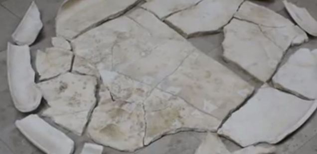
According to an Archaeology in Bulgaria report, more than 100 pieces of a household table dated to the fourth century A.D. have been found in one of the towers at the Petrich Kale Fortress, which is located on a plateau in northeastern Bulgaria near the coast of the Black Sea.
Even though the rare artefact, an ancient marble table signifying the presence of a high-ranking Roman official, has been found broken, almost all of its pieces are in place, allowing the restorers from the Varna Museum of Archaeology to put it back together.
Petrich Kale is a fortress which was in used for about 1,000 years by the medieval Eastern Roman Empire (Byzantine Empire) and the medieval Bulgarian Empire, up until the region’s conquest by the Ottoman Turks. The Petrich Kale Fortress is located in Avren Municipality, right outside of the Black Sea city of Varna (it should not be confused with the modern-day town of Petrich in Southwest Bulgaria).
The Petrich Kale Fortress was established in the Late Roman and Early Byzantine period, in the 5th century AD, and was destroyed by the end of the 6th century by barbarian invasions. It was rebuilt in the 11th century and became a major stronghold in the Second Bulgarian Empire (1185-1396). In 1154 AD, medieval Arab geographer Muhammad Al-Idrisi wrote that Petrich was a “thriving small town” to the west of Varna.
The Petrich Kale Fortress was ultimately destroyed for good by the Ottoman Turks in 1444 AD, three days before the Battle of Varna, in which they defeated the second and last Christian Crusade of the King of Poland and Hungary, Wladislaw III (also known as Varnenchik because he found his death in the Battle of Varna).
An archaeological team from the Varna Museum of Archaeology has found the white marble table from the 5th century AD inside the ruins of the southern tower of the Petrich Kale fortress during excavations in the fall of 2020, BTA reports.
The marvellous 4th-5th century white marble table has been found inside one of the towers of the Petrich Kale Fortress near Bulgaria’s Varna.
“It is one of the nicest finds from our latest excavations of the Petrich Kale fortress,” says Assist. Prof. Maria Manolova-Voykova from the Varna Museum of Archaeology.
“It is a round table made of white marble, and is known in scientific literature as a table from the “raven beak” type due to its typical profile, with its top slightly curled inwards,” she explains.
Manolova-Voykova notes that similar white marble tables from the Late Roman and Early Byzantine period are known from the Eastern Mediterranean, where samples have been found in Greece and Turkey. The 5th-century table from the Petrich Kale fortress near Varna is the first one of its type to have been discovered in Bulgaria.
“Interestingly, unlike most [late Antiquity and early medieval] marble tables, which are connected with some liturgy functions from the Christian period, this type of tables have more of a secular character and household usage, as a household item showing the well-being of the respective residence,” the archaeologists say.
“Because of that, it was very interesting for us to discover this table in one of the fortress towers, which showed that the tower probably was the residence of some high-ranking administrator, perhaps dealing with the defence of the fortress, or perhaps its very governor,” she elaborates.
“Of course, for the time being, those are just conjectures but it is a fact that we found the marble table in a layer connected with the 4th century AD (i.e. the Late Roman period),” Manolova-Voykova states.
The Late Roman/Early Byzantine white marble table has been discovered shattered in more than 100 pieces but is expected to be fully restored.
Her team has found the white marble table from the Late Roman / Early Byzantine period while clearing up construction debris inside the southern fortress tower of the Petrich Kale fortress. In addition to the shattered table, the archaeologists found inside numerous pottery fragments and Late Roman and Early Byzantine coins.
Artist and restorer Milen Marinov, who is in charge of the restoration of the 5th-century white marble table from the Petrich Kale Fortress, notes that it has been found in more than 100 pieces. Yet, it will probably be restored at almost 100% with patience and diligence as there are very few missing pieces. Marinov praised the archaeologists who recovered the precious Antiquity artefact for saving even pieces as tiny as 1 centimetre.
He adds he is using various types of glue in order to make sure that the restored table will be simultaneously solid and natural-looking once it is exhibited for the visitors of the Varna Museum of Archaeology. The museum itself boasts one of the richest archaeological collections in Bulgaria, not least the world-famous Varna Gold Treasure, the world’s oldest. The medieval Byzantine and Bulgarian fortress Petrich Kale are located 4 km north of the town of Avren, Avren Municipality near the Black Sea city of Varna, in Northeast Bulgaria (not to be confused with the modern-day town of Petrich in Southwest Bulgaria); it is also 1 km away from the Razdelna railway station.
An aerial view of the Petrich Kale fortress south of the Beloslav Lake and the Varna Lake, near Bulgaria’s Varna.
A map of the Petrich Kale fortress near the Black Sea city of Varna in Northeast Bulgaria.
A map of the Petrich Kale fortress near the Black Sea city of Varna in Northeast Bulgaria.
It is located on a high rock plateau towering at up to about 100 meters, on a territory of about 30 decares (app. 7.5 acres). It had an inner and outer fortress wall as well as stone stairs carved into the rock on the north side of the plateau. Archaeological exploration indicates that the Petrich Kale Fortress was first established during the Early Byzantine period, in the 5th-6th century AD, but was destroyed towards the end of the 6th century AD.
(“Кale” is a Turkish word meaning “fortress” leftover from the Ottoman period commonly used for the numerous ruins of ancient and medieval fortresses all over Bulgaria, whose proper names are sometimes unknown.)
It was rebuilt in the 11th-12th century, the period when Byzantium conquered the First Bulgarian Empire (632/680-1018 AD) and was a major fortress of the Second Bulgarian Empire (1185-1396 AD) during the 13th-14th century. The Petrich Kale Fortress was completely destroyed in 1444 AD by the Ottoman Turks who had conquered all of Bulgaria in 1396 AD, after the Second Crusade against the Ottoman Empire led by Wladislaw III, King of Poland, Hungary, and Croatia, who perished in the Battle of Varna (which is why he is also known as Varnenchik – Warnenczyk in Polish).
The Petrich Kale Fortress was destroyed by the Ottoman Turks on November 7, 1444, three days before the Battle of Varna on November 10, 1444, in which the Christian Crusaders were defeated. Thus, the Petrich Kale Fortress is connected with the history of the Central European states Poland, Hungary, and the Czech Republic.
The Petrich Kale Fortress was first mentioned in written sources in 1154 AD by medieval Arab geographer Muhammad Al-Idrisi who described it as a “small thriving town” west of Varna. Later it was mentioned by Byzantine poet Manuel Philes (ca. 1275-1345 AD) in connection with the military campaign of Byzantine general Michael Tarchaeneiotes in Northeast Bulgaria in 1278 AD.
It was also mentioned in documents of the Ecumenical Patriarchate in Constantinople in 1369 AD and in numerous accounts of the Second Crusade of King Wladislaw III against the Ottoman Turks. The Petrich Kale Fortress near Varna was excavated by Bulgarian archaeologists in the 1970s; in recent years, the archaeological excavations were resumed in 2010 by the Varna Museum of Archaeology (Varna Regional Museum of History).
Egyptian pyramids found by infra-red satellite images
When Egypt was conquered by Napoleon Bonaparte in 1798, he took along with his vast army more than 150 scientists and scholars. The scholars fanned out throughout Egypt, explaining the natural and cultural history of the land, mapping archaeological sites from Alexandria to Aswan, and bringing for the first time the scientific world to the attention of places such as the Valley of the Kings.
This week, an American research team announced that it has succeeded in a high-tech follow-on to Bonaparte’s grand survey. By analyzing high-resolution satellite imagery covering all of Egypt, researchers have reportedly discovered up to 17 lost pyramids, nearly 3000 ancient settlements, and 1000 tombs.
The effort was led by archaeologist Sarah Parcak of the University of Alabama, Birmingham. The team’s work will be highlighted in a BBC documentary in the United Kingdom and later on the Discovery Channel in the United States.
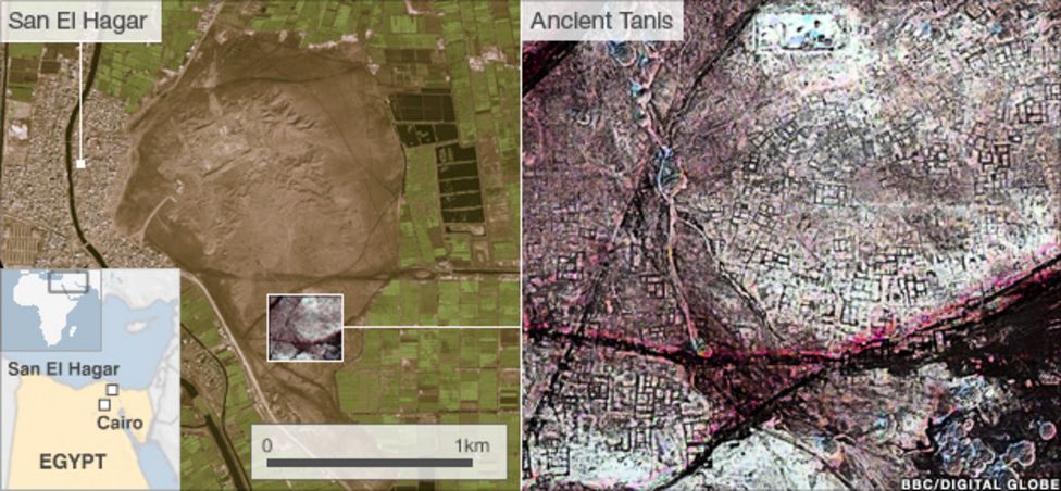
Satellite imagery reveals a maze of streets and buildings at the ancient Egyptian city of Tanis.
An infra-red satellite image shows a buried pyramid, located in the centre of the highlight box.
The findings are groundbreaking, says Egyptologist Willeke Wendrich of the University of California, Los Angeles, who has followed closely the team’s as-yet-unpublished work. “It gives us the opportunity to get at the settlement of ancient Egypt without digging even a centimetre,” she says.
In the wake of the finds, the Egyptian government reached an agreement this week to work with Parcak and other American researchers to develop a nationwide satellite imagery project to monitor archaeological sites from space and protect them from looting and illegal house construction and other encroachments.
A satellite image shows a field of what may be buried pyramid sites in Egypt.
“We are going to be teaching young Egyptians how to look at the satellite data and analyze it so they can keep an eye on these sites,” Parcak says. She and her colleagues plan to raise funds privately to support the effort.
Parcak began her study 11 years ago, searching for traces of ancient village walls buried under Egypt’s fields and desert sands.
Obtaining images from both NASA and QuickBird satellites, she combined and analyzed data from the visible imagery as well as the infrared and thermal parts of the light spectrum. Through trial and error, she discovered that the most informative images were taken during the relatively wet weeks of late winter.
During this period, buried mud-brick walls absorbed more moisture than usual, producing a subtle chemical signature in the overlying soil that showed up in high-resolution, infrared satellite images. These places became “our hot spots, the places that we could end up exploring on foot,” Parcak says.
Sarah Parcak examines satellite imagery of an Egyptian landscape.
The team found 17 buried pyramid-shaped structures, including one at Saqqara, famed for its numerous pyramids. That sighting was confirmed by a team of Egyptian archaeologists who excavated part of what is now thought to be a late Middle Kingdom pyramid at the site.
The other 16 structures look like pyramids from space but could be elite tombs, Parcak says. “Let’s be honest, we won’t know if those pyramids are pyramids until we excavate,” she says.
To further test some of the most recent satellite finds, Parcak enlisted the help of a French archaeological team already digging at a 3000-year-old site known as Tanis.
The satellite data revealed a warren of mud-brick walls, mazelike streets, and large residences that may have housed the wealthy. So the French team chose a structure from the images and excavated there. Beneath about 30 centimetres of sediments, they discovered mud-brick walls.
“They found an almost 100% correlation between what we see on the imagery and what we see on the ground,” Parcak says. “So this gives a significant amount of credence to what we see in the whole image.”
“It’s really incredible work, particularly the results for Tanis,” says Peter Lacovara, an Egyptologist at the Michael C. Carlos Museum in Atlanta, who is not a member of Parcak’s team. “You can see the entire city plan under the sands.”
The greatest payoff may become apparent in years to come, adds Lacovara, as the Egyptian government develops a space-based archaeological monitoring system founded on satellite data.
“Ancient sites are all over the place in Egypt,” Lacovara concludes. “And there’s just not enough time and money to monitor them on the ground.”
City Found 360 Feet Below Missouri City, Giant Human Skeleton Found
When coal miners at Moberly, Missouri were drilling a shaft 360 foot deep, broke into a cavern revealing “a wonderful buried city,” multiple sources reported in 1885.
City Found 360 Feet Below Missouri City, Giant Human Skeleton Found Coal miners in the city of Moberly, Missouri mining a shaft 360 feet deep, broke into a cavern revealing “a wonderful buried city,” multiple sources reported in 1885. Incredible rude style masonry and artefacts have been identified.
Masonry and artefacts in extraordinary rude design have been found. Like stone tables, bronze and flint knives, stone and granite hammers, metal statues, metallic saws and a stone fountain that flowed with “perfectly pure water”, which was found to be impregnated with lime.
“Lying beside the fountain where portions of a human being and from the measurement of the bones, it concluded that when alive the figure was three times the size of an ordinary man and possessed of wonderful muscular power and quickness. “, according to the St Paul Daily Globe.
The Semi-Weekly South Kentuckian published the measurements of the giant’s leg, “The bones of the leg were measured, the femur measuring 4 and 1/2 feet, the tibia four feet and three inches. The head bones had separated in two pieces, the sagittal and cornal suturis having been destroyed”
The city was arched in by a hard and thick stratum of lava. The civilization used a regularly laid out road system enclosed by walls to travel around. A hall was discovered wherein were stone benches, tools of all descriptions for mechanical service.
The searching party spent twelve hours in the depths and only gave up explorations because of the oil in their lamps being low. No end to the wonderful discovery was reached.
The statues were not accurately made as those made by the mechanics in the year 1885, however, they demonstrated much skill and evidence of an advanced civilization.
The facts above are vouched for by Mr David Coates, the recorder of the city of Moberly, and Mr George Kealing, City Marshall, who were of the exploring party.
I could find no record of the 2nd exploration. Perhaps in the historic papers on film, in the town of Moberly, information may still exist.
In order to find 8 newspaper stories, I needed to search “stratum of lava” 1884-1886.
In an odd coincidence the terms “cave + Missouri”, “Missouri + cave + coal mine”, “Missouri cave fountain”, “Missouri gaint” and countless other rational terms would not locate these articles on the library of congress website.
It seems you need to be clever in your search terms in order to locate historical articles that are relevant.
9,350-Year-Old Stonehenge-Style Monolith Found in the Mediterranean Sea
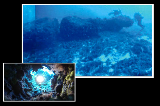
At least 9,300 years ago, Stone Age hunter-gatherers in a now-submerged area of the Mediterranean Sea accomplished a feat beyond what today’s experts thought possible for the time: they cut a 15-ton limestone pillar with precision, drilled holes in it and transported it nearly 984 feet (300 meters). The monolith is 39 feet (12 meters) long.
Underwater composite photographs taken from divers, showing the discovered monolith and some details. Top: full lateral view. Bottom: full view from above.
Oceanographers studying the Mediterranean seafloor in the Sicilian Channel between Tunisia and Sicily in 2012 found the monolith 131 feet (40 meters) deep.
In a new paper in the Journal of Archaeological Science, the researchers say this area became completely submerged about 9,300 years ago, give or take a couple of hundred years. Before that, the area was a shallow sea with an archipelago of several islands about halfway between the island of Sicily and the North African coast.
The area studied, the Pantelleria Vecchia Bank, is now undersea between Sicily and Tunisia.
So it is assumed the pillar was carved at least 9,300 years ago. Researchers were able to date the stone of the monolith by extracting shell fragments from it. They found it has the same composition and age as limestone about 330 yards away, suggesting it was transported this distance.
The researchers say the discovery of this submerged pillar may require scholars to rethink the idea of “technological primitivism” among hunter-gatherers.
Researchers say the discovery of this submerged pillar may require scholars to rethink the idea of “technological primitivism” among hunter-gatherers.
“This discovery provides evidence for a significant Mesolithic human activity in the Sicilian Channel region,” wrote Emanuele Lodolo and Zvi Ben-Abraham in their paper.
Lodolo and Ben-Abraham state that several factors lead them to believe the monolith or stone column was cut by humans and was not shaped by nature.
They write that the monolith has a regular shape and three regular holes of similar diameter. It is composed of limestone of a nature similar to rocks not far away from where it was transported, but it differs from the rocks in the immediate vicinity.
The submerged monolith
Underwater composite photographs taken from divers, showing the discovered monolith and some details. Top: monolith’s end. Middle: partial lateral view. Bottom: partial view from above.
“The presence of the monolith suggests extensive human activity in the [area],” they wrote. “It was cut and extracted as a single stone from the outer rectilinear ridge situated about 300 m [984 feet] to the south, and then transported and possibly erected. From the size of the monolith, we may presume that it weighs about 15 [tons].”
They did not speculate about the function of the monolith. But they assume it was in an important area, which is about halfway between Sicily and Tunisia. Sicily was inhabited possibly between 17,000 and 27,000 years ago, when there was a land bridge from the Italian mainland.
“The discovery of the submerged site in the Sicilian Channel may significantly expand our knowledge of the earliest civilizations in the Mediterranean basin and our views on technological innovation and development achieved by the Mesolithic inhabitants,” the authors wrote.
“The monolith … made of a single, large block, required cutting, extraction, transportation, and installation, which undoubtedly reveals important technical skills and great engineering.”
The researchers even went so far as to state that: “The belief that our ancestors lacked the knowledge, skill, and technology to exploit marine resources or make sea crossings, must be progressively abandoned.
The recent findings … have definitively removed the idea of ‘technological primitivism’ often attributed to hunter-gatherer coastal settlers.”
Discovery of massive island ritual site where people gathered 5,500 years ago
The discovery of a cursus monument site at Tormore on the Isle of Arran, which is more than a kilometer long, is helping to reshape Neolithic history in Scotland with such landmarks usually associated with the east coast.
The previously unknown large Neolithic ritual site has been found on the Isle of Arran.
Cursus monuments were often defined by long lines of timber posts, forming a long rectangle, and were amongst the most spectacular features in the Neolithic landscape.
The posts may have served as a procession route, perhaps to honour the dead. Some were burned to the ground in an almighty display which is believed to have been part of the ceremonies associated with these huge monuments.
Dave Cowley, Rapid Archaeological Mapping Programme Manager at Historic Environment Scotland, who discovered the site following a laser scan of Arran, described the cursus monument as a “cathedral of the day”.
He said: “I think if you asked the survey team what they thought they were most likely to find on Arran, I would bet you no one would say a Neolithic cursus monument
“There is no other on Arran, it’s unique on the island, there is one more in Kilmartin Glen and that is pretty much it for the western seaboard.
“What this example at Tormore tells is there are probably actually many more on them but because they were built from timber, you are not likely to see them in the unimproved peat landscape of the west coast.
The site of the cursus monument was discovered after these two parallel lines, marked here by red arrows, were picked up by a laser scan of Arran landscape.
“Arran has got some cracking Neolithic and Bronze Age archaeology but we are still surprised that this monument is here.
“It adds a whole additional dimension to what the archaeology of the Neolithic on Arran can tell us. It is like finding a whole new layer in a box of chocolates of new things.”
Mr. Cowley detected the site after picking up two lines of mounds, which lie roughly parallel and stand 30 to 40 centimeters high, and which run for around a kilometer.
He said: “When you look at the topography, it very slightly runs to the crest of a ridge. They have been very careful about how they have positioned this monument. There probably was a superstructure here but we won’t know for sure without excavation.
“It would have had an impact. There is an element of design to it, a form of landscape architecture.
“It does seem likely that there were timber elements built into it. Whether or not it was set on fire we just don’t know at the moment. “
Mr Cowley said the monuments probably brought together “quite dispersed populations together in a communal activity” and that different community built different parts of the monument.
The site was discovered following an aerial laser scan of the site using Light Detection and Ranging (Lidar) technology, which uses laser pulses to measure objects.
Images can then be reworked by filtering out vegetation or by changing the way it is lit which can then reveal previously unknown characteristics in the land. More than 1,000 unknown archaeological sites have been found on Arran using the technology.
Arne Anderson Stamnes, an archaeologist at the NTNU University Museum, was observed methodically making his way back and forth across the fields just east of the campsite in the municipality of Bodø in November 2019. He is towing a ground-penetrating radar device behind the four-wheeler he is driving.
The ground was frozen and the field was covered with a fine layer of snow – ideal conditions for this type of archaeological research.
GPR sends electromagnetic signals down into the subsurface, and some of these signals are reflected back when they encounter structures deeper down in the ground. This is how archaeologists obtain a kind of X-ray of objects two to three meters below the surface.
Stamnes quickly finds that the ground here is content-rich, to put it mildly. The results are astonishingly good and they whet your appetite for more, says Nordland county archaeologist Martinus A. Hauglid.
One of the region’s largest burial mounds
“Our findings included traces of 15 burial mounds, and one of them appears to contain a boat grave. Both the size and design of the burial mounds are typical of the period 650 to 950 CE—that is, what we call the Merovingian Period and Viking Age,” says Stamnes.
“A lot of the mounds are big. The largest burial mound has an inner dimension of 32 meters and must have been a towering presence in the landscape,” he says.
In fact, this giant mound is one of the largest burial mounds known in the region. But this isn’t what aroused the greatest enthusiasm among archaeologists. Previous studies indicated the presence of a plowed over burial ground right here, and this was an important reason why Bodø municipality and the Nordland County Council wanted to investigate the area with GPR.
What they didn’t know beforehand was that an ever-so-small mystery lurked underground. Or perhaps we should say many mysteries.
The study area was full of discoveries.
Intriguing mystery
As Stamnes trawls back and forth across the fields, more and more oval ditches appear on the screen, totaling 32 in all. You may not think oval ditches sound particularly mysterious or sexy—it’s not like you hear the Game of Thrones theme song in the background when someone whispers “oval ditches.” However, this is actually something that has not been seen before.
“I’ve asked a few of my colleagues, but so far haven’t found anything similar to this find in other excavations. So it’s difficult to conclude what it might be,” Stamnes says.
“The shape and the fact that most of the ditches have a clear orientation with the short end towards the sea—probably also the dominant wind direction—make it likely that this was a type of house foundation,” he said.
He adds that the GPR images do not show any traces of buried firepits inside the ditches, which indicates that they might have had a more temporary function.
“Maybe they served as a kind of market stall. It’s also possible to interpret such constructions as semi-permanent house foundations, also called “búðir”, which are known from assembly places in Iceland.
Still impossible to say what the ditches are
Archaeologist Jørn Erik Henriksen at the Norwegian Arctic University Museum says that it’s not possible to say anything more definitive about what the oval ditches are until excavations have been made. However, he thinks Stamne’s interpretation is interesting.
Our findings included traces of 15 burial mounds. The size and design of the burial mounds are typical of the period 650 to 950 CE.
“I’m fascinated by the idea that there might be stalls connected to larger crowds gathering on the site,” says Henriksen. The GPR surveys also revealed 1257 pits of various sizes. It’s even harder to say for sure what all these are. Most likely they’re a bit of everything—from cooking pits and post holes to nothing special.
“What we can say is that these pits are another sign that this area has been packed with human activity,” says Stamnes.
Seat for chiefdom?
According to some theories, the area around the earlier Bodin municipality—including the scanned areas—was once the seat of a chiefdom that had sovereignty in the Salten district.
So the question is: does the archaeological investigation confirm this hypothesis?
Henriksen says he’d like to see similar investigations done at other contemporaneous central sites in the area before uncritically proclaiming this as the power headquarters.
“However, the findings have in no way weakened the hypothesis that this place was the center of power in Salten, on the contrary!” he says.
The scanned area is seen from above. Previous studies indicated the presence of a ploughed burial ground right here.
A mighty family
In any case, there is little doubt that a powerful family lived here, based on the size and number of the tombs gathered in one burial ground. Eight of the burial mounds are circular in shape, while seven are oblong. Long mounds are often interpreted to be female graves, so judging by the numbers, the burial ground contains an even gender balance.
“Five of the round grave monuments have a diameter greater than 17.5 meters, where the largest measures about 32 meters. The long mounds are between 17.7 and 29 meters long,” Stamnes says.
“Building such large tombs is resource-intensive, so it’s plausible that the people buried here had great power and influence, both locally and regionally,” he says.
County archaeologist Hauglid agrees.
“Bodøgård was the seat of the sheriff—and later the county governor—in the Nordland region from the beginning of the 17th century, while Bodin church nearby is a stone church from the Middle Ages. The burial ground that has now been discovered testifies that a political-religious power center has existed here since the Late Iron Age.
“A new city quarter has given us the chance to explore an area we’ve long been curious about. We can even see from aerial photos that there’s something under the ground. The findings from the investigation have yielded a long-awaited and exciting mystery,” says Ingrid Nøren, the manager for the New City—New Airport project in Bodø municipality.
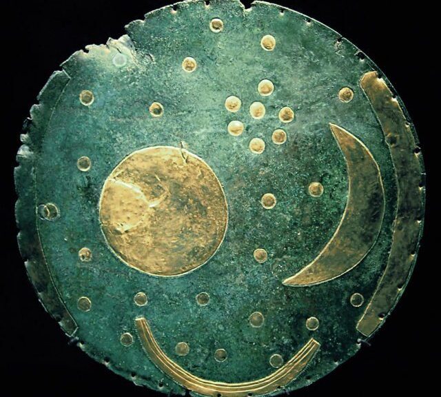
Dated to c. 1600 BC, the Nebra sky disk is one of the most important archaeological finds in the 20th century
In the eastern German town of Halle, the 3,600-year-old Sky Disk of Nebra, the world’s oldest image of the cosmos, is the centerpiece of Europe’s greatest Bronze Age exhibition. When it was brought to the German public’s notice in 2002, having been found in the state of Saxony-Anhalt two years earlier, it caused a worldwide sensation.
Now the Sky Disc of Nebra — a bronze disc with gold-leaf appliques representing the sun, moon, stars, and a ship — is back in the limelight, at the opening of a blockbuster show entitled “The Forged Sky: The Wide World in the Heart of Europe 3,600 Years Ago.”
For the first time the disc, which is around 32 centimeters (12 inches) in diameter and weighs about 2 kilos (1 pound), will be on public view in its fully restored state.
Archeologists have dated the disc to 1600 B.C.
1,600 artifacts
In addition to the oldest concrete representation of the cosmos known to date, the Forged Sky exhibit, at the State Museum of Prehistory in the town of Halle, will feature the Sun Chariot of Trundholm (Denmark) and 1,600 more of the most important archeological finds representing Europe in the Bronze Age.
When it was discovered, the Sky Disc was considered a key find not only for archaeology but also for astronomy and the history of religion. Deposited some 3,600 years ago, it was found on the summit of the Mittelberg hill, near the wooded area of Nebra in eastern Germany, together with valuable swords, jewelry, and tools.
The find initiated a new presentation of the Bronze Age world in Central Germany. The natural riches of this region — copper, salt, and fertile soils — formed the power basis for the resident Early Bronze Age princes, who exchanged goods from all regions of Europe. Mighty tombs, extensive bronze treasures, gold jewelry, and unique display weapons survive as their status symbols, and a representative sample of them is pulled together for the current blockbuster show.
Crowds expected
“Peoples’ interest in the disc since it was unearthed two years ago has not let up,” Saxony-Anhalt state archeologist Harald Meller told the DPA news agency. He explained: “We put the show together in record time, 18 months.”
Meller said he expects 100,000 people to visit the exhibit. If there is enough interest, he said, the show will be extended. The objects on view have been donated by 68 museums in 18 countries.
“Most of the objects, like burial offerings, cult objects, gold jewelry, and various decorated armaments, have never before been out on loan, and they will only be gathered together like this for the show in Halle,” Meller told DPA. Aside from European countries, Lebanon also loaned some pieces to the show.
Sun chariots and golden boats
For example, the organizers got special permission to borrow the 3,400-year-old Sun Chariot of Trundholm from its home at the National Museum in Copenhagen, for the duration of the Halle show.
Sun Chariot of Trundholm, Denmark
The National Museum had previously decided that, for security reasons, the 50 centimeters long, 30 centimeters high Sun Chariot should never again leave Denmark. Similarly, the 88 super thin golden ships from Nors, Denmark, are so brittle that they hardly ever leave the National Museum, according to museum director Flemming Kaul.
But having a group of artifacts from around Europe is important, because “We show that … there is a long process of developing knowledge about religion and astronomy in Europe, which is part of the history of mankind,” Meller said.
The disc itself was a cult object and describes the world view during the Bronze Age. People imagined the earth as a disc, with a dome-shaped sky covering it. A cluster of seven dots has been interpreted as the Pleiades constellation as it appeared 3,600 years ago.
A Nebra baker made this reproduction of the sun disc out of butter cream and marzipan.
At the same time, the piece is thought to be related to primitive observatories, one of which is the “German Stonehenge” in the nearby town of Goseck.
Archeologists believe the disc may have been used in the pre-calendar Bronze Age as an instrument for determining seasonal changes.
The popularity of the disc has led to a boom in reproductions. Demand for €800 ($990) copies of the disc is booming: “There are already 50 on order, and the fabricator can barely keep up with production,” Meller said.
On the other hand, the disc’s popularity can’t stanch the flood of lawsuits that followed its discovery. Although the copyright case was decided in favor of the state of Saxony-Anhalt, there is still a suit before the Halle appeals courts against two suspected fencers from North-Rhine Westphalia who claim the Sky Disc is a fake that was found outside of Germany.
The disc was found on July 4, 1999, by two convicted grave robbers. In February 2002 it was bought along with other Bronze objects from art fencers in a police operation in Switzerland.