Oldest North American Rock Art May Be 14,800 Years Old

Oldest North American Rock Art May Be 14,800 Years Old

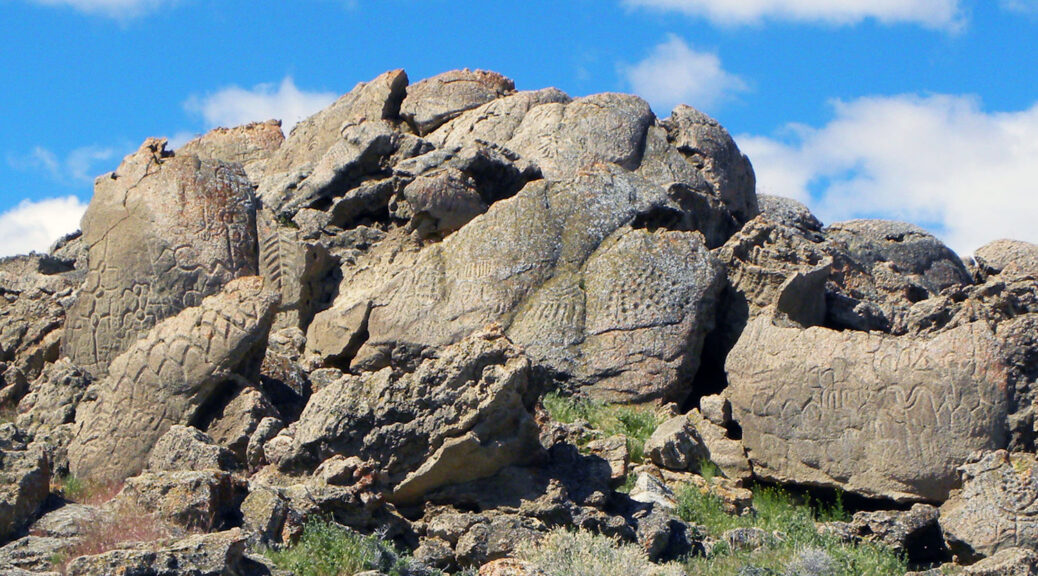
A rock engraved with ancient marks discovered on a dried-up lakebed in Nevada carries dated as of the oldest known petroglyphs in North America, at least 10,000 years old.

The petroglyphs found on limestone boulders near Pyramid Lake in northern Nevada’s high desert are similar in design to etchings found at a lake in Oregon that is believed to be at least 7,600 years old.

Unlike later drawings that sometimes depict a spear or antelope, the carvings are abstract with tightly clustered geometric designs – some are diamond patterns, others have short parallel lines on top of a long line.

This May 2012 photo provided by the U.S. Geological Survey shows ancient carvings on limestone boulders in northern Nevada’s high desert near Pyramid Lake. The carvings have been confirmed to be the oldest recorded petroglyphs in North America – at least 10,500 years old.

Scientists can’t tell for sure who carved them, but they were found on the Pyramid Lake Paiute Tribe’s reservation land.

“We initially thought people 12,000 or 10,000 years ago were primitive, but their artistic expressions and technological expertise associated with these paints a much different picture,” said Eugene Hattori, the curator of anthropology at the Nevada State Museum in Carson City who co-authored a paper on the findings earlier this month in the Journal of Archaeological Science.

The petroglyphs could be as much as 14,800 years old, said Larry Benson, a geochemist who used radiocarbon testing to date the etchings and co-wrote the paper.

Radiocarbon testing dated the carbonate layer underlying the petroglyphs to roughly 14,800 years ago. Geochemical data and sediment and rock samples from adjacent Pyramid Lake show they were exposed to air from 13,200 to 14,800 years ago, and again from 10,500 to 11,300 years ago.

“Whether they turn out to be as old as 14,800 years ago or as recent as 10,500 years ago, they are still the oldest petroglyphs that have been dated in North America,” said Benson, a national research scientist emeritus for the U.S. Geological Survey and curator of anthropology at the University of Colorado Natural History Museum in Boulder.

Dennis Jenkins, an archaeologist with the University of Oregon’s Museum of Natural and Cultural History, called it a significant discovery. He led recent excavations of obsidian spear points near Paisley, Ore., that he dated back 13,200 years, and noted that the bigger challenge is identifying who created the petroglyphs.

“When you get back into this time period, if you speak with Native Americans they will tell you they were made (created) there and that is obviously their people and their artwork,” Jenkins said. “But approaching it from a scientific point of view – what we can prove – at this point, it is impossible to connect these to any tribal group.”

William Cannon, a longtime archaeologist for the U.S. Bureau of Land Management who discovered the petroglyphs at Long Lake in Oregon, brought the Nevada site to Hattori’s attention years ago. He said they bore similarities to petroglyphs at nearby Winnemucca Lake, and Hattori began connecting the dots.

Winnemucca Lake

The etchings in Nevada and Oregon have relatively deep, carved lines dominated by linear, curved and circular geometrical designs. Some feature “tree-form designs” with a series of evenly spaced, vertically oriented V shapes bisected by a vertical line.

Researchers have suggested the etchings represent various meteorological symbols, such as clouds and lightning, perhaps the Milky Way.

“But we really have nothing to go on for these particular petroglyphs that go back 10,000 or more years,” Hattori said.

Benson has no idea what they mean.

“When I looked at it, I said, ‘These things are incredibly beautiful.’ We have so much beautiful, old Native American stuff in the United States, but this shows it didn’t necessarily get more interesting or more pretty with time,” he said.

Ben Aleck, a co-author of the study who is the collection manager at the Pyramid Lake Paiute Tribe’s Museum and Visitor Center in Nixon, said he could not comment without permission from tribal leaders.

Hilltop Buddhist Monastery Uncovered in Eastern India

Hilltop Buddhist Monastery Uncovered in Eastern India

The first hilltop Buddhist monastery of the Gangetic Valley has been found at Lal Pahari in Lakhisarai district of the state, said its excavation team director Anil Kumar. Excavated during a joint collaboration of the Bihar Heritage Development Society, a part of the department of art, culture and youth affairs and the Visva-Bharati University, Santiniketan, West Bengal, this finding is believed to be a great centre of Mahayana Buddhism.

The 11th-12th century common era (CE) monastery has some unique features rarely found elsewhere in the country and certainly not in Bihar. Besides wooden votive tablets found, it is the first Buddhist monastery which had a woman monk named Vijayashree Bhadra as its chief. She used to receive donations from Pala queen Mallika Devi.

A large number of metal bangles have been found and all its cells had doors, something unusual for the Buddhist monasteries excavated so far, suggesting that either it was exclusively for woman monks or a mixed one.

Excavated during a joint collaboration of the Bihar Heritage Development Society, a part of the department of art, culture and youth affairs and the Visva-Bharati University, Santiniketan, West Bengal, this finding is believed to be a great centre of Mahayana Buddhism.

The two burnt clay seals recovered from the site record the name Srīmaddharmahāvihārik āryabhikṣusaṅghasya (the council of monks of Śrīmaddhama vihāra). The language used is Sanskrit and the script is Siddhamātṛkā of about 8th-9th century CE.

The name is equally significant as it indicates how much prestige the Mahāyāna Buddhism enjoyed in early medieval Magadha.

The wooden votive tablets of 5.3×2.3cm each have the figure of a person, probably Buddha, sitting in Padmasana in Bhumisparsha mudra. The lintel at the entrance of the main sanctum sanctorum represents the two Bodhisattvas — Manjushri and Avalokiteshvara.

Anil, who is the head of the ancient history and archaeology department at Visva-Bharati in Santiniketan, said it’s the first ‘vihara’ in the state, which probably gave Bihar its name, like those found at Nalanda, Vikramshila and Telhara were ‘mahaviharas’.

Also, after Nalanda and Telhara in Bihar, any monastic sealing has mentioned the monastery name. While a number of mahāvihāras and in one instance a vihārikā is known from epigraphic and archaeological records of eastern India, no evidence of a ‘vihara’-level monastic architecture has been so far discovered from any part of Bihar.

The only parallel evidence is found in a monastery excavated at Jagjivanpur in northern Bengal, he said.

These findings will be significant in the understanding of the history of monastic Buddhism in early medieval Magadha in general and the history of the historically identified Kṛmilā region in Lakhisarai in particular. This evidence clearly proves that the monastery atop Lal Pahari at Jaynagar was a ‘vihāra’, he explained.

He said the interconnected cells, wooden door frames, three huge bastions on each side of the monastery, the discovery of dozens of wooden inscribed seals/sealings and the evidence of application of red, green, yellow, white and black colours on lime-plastered floors make the architecture of this monastery the first of its kind among the eastern Indian Buddhist establishments.

Anil said this was the first excavation project completed within 3 years in Bihar after getting a licence from the Archaeological Survey of India (ASI) and signing a memorandum of understanding (MoU) with the Bihar government in 2017. CM Nitish Kumar had inaugurated the Lal Pahari excavation site on November 25, 2017.

“We have documented 500 sculptures lying all around the site and brought 200 of them to Lakhisarai. The state government should urgently preserve these sculptures as Lal Pahari is one of the five protected monuments of Bihar government in Lakhisarai.

The other four are Satsanda, Bichhwe, Ghosi Kundi and Lai. The 6th site at Nongarh is also being considered for inclusion in the list,” Anil told TOI.

5,450 years old Egyptian knife known as Gebel el-Arak, made with an Ivory handle

5,450 years old Egyptian knife known as Gebel el-Arak, made with an Ivory handle

This unique dagger from the late predynastic period consists of a light silex blade, sculpted using a highly sophisticated technique, and an ivory handle featuring carved bas-relief scenes. It is one of the oldest known examples of bas-relief sculpture.

The themes come from Nilotic as well as Mesopotamian traditions: animals, the hunt, lions overwhelmed by a figure, boats, and human combats.

A luxury object

Everything in this weapon illustrates luxury and technical expertise. The blade, made of extremely high-quality, light ocher slate, reflects an accomplished mastery of stone-cutting techniques. Parallel strips were removed on one side to form a regular pattern.

The other side of the blade is simply polished. Small areas were reworked to form a sharp serrated edge. Egyptian craftsmen used this meticulous technique for a short period only, between 3500 and 3200 BC.

This is the most accomplished example of the silex tool-making technique. Analyses of the handle determined that it is made of a hippopotamus tooth.

Only a small number of ivory dagger handles of this type, decorated with relief carving, exist. These were exceptional works, reserved to an elite.

Detail of warfare depicted on the Gebel el-Arak knife.

Men and animals

Detail of the battle and animal scenes on the Gebel el-Arak Knife.
One side of the richly carved ivory handle displays apparent hunting scenes filled with animals.

The blade is set into a carved hippopotamus tooth and has a central knob with a hole for attaching a cord. On one side is a bearded figure wearing a cap, standing between and subduing two lions. Below are two domesticated dogs and wild animals; a hunter seems to be catching an antelope.

Ripple-flaked side and polished side of the Gebel el-Arak Knife.

The other side depicts combats arranged in several registers. At the top are quasi-nude men wearing penis sheaths, in hand-to-hand combat. At the bottom, dead bodies are strewn between two different types of boats, both in use in Egypt during the Naqada period.

A key work

Animal life, hunting, and boating on the Nile are ancient themes that had already appeared on ceramics and paintings during the Naqada Period.

The bas-relief carving that appeared at this time on large contemporaneous palettes depicted more dynamic and less static scenes than images on earlier traditional ceramic pieces.

Furthermore, the battle theme appeared toward the end of this period, which is why researchers have tried to find a narrative link to historical events.

Today they are interpreted more as referential images, a catalogue of themes that were important to the ruling class during a period when the Egyptian state was taking shape.

As is often the case, certain motifs are variations of those from the contemporaneous Mesopotamian culture, such as the bearded figure of the priest-king (AO5718, AO5719) and the “Master of Animals” figure subduing two beasts. Direct or indirect contacts certainly existed between the two civilizations.

The design of superimposed registers and the conventions used to represent the human figure were used throughout the entire pharaonic period. This object illustrates the shift from the late predynastic period to the birth of the pharaonic civilization.

1,500-Year-Old Tomb Discovered in Central China

1,500-Year-Old Tomb Discovered in Central China

China Daily reports that a tomb dated to the Sui Dynasty (A.D. 581–618) has been unearthed in central China’s Henan Province.

The tomb, which contains a coffin bed and screen made of white marble carved with patterns resembling those found in Zoroastrianism and Buddhism, belonged to a previously unknown couple named Qu Qing.

An epigraph unearthed from the tomb records the life experience of the tomb owners, a couple with the name Qu Qing, who never appeared in any historical files before.

This is a copy of an epigraph that was unearthed from a Sui Dynasty (581-618) tomb in Anyang, Central China’s Henan province.

The epigraph provides new evidence for character evolution and the art of calligraphy during the Sui Dynasty, according to the Anyang Institute of Cultural Relics and Archaeology, adding that it also has great value as complementing the institute’s history section.

Various patterns strongly in the style of Zoroastrianism were carved on the coffin bed and the screen, showing the daily life of the tomb owners and some religious allusions.

“The Qu family lived in the Longxi area, which occupied the main part of the Silk Road for a long time, so they were deeply influenced by European, West Asian and Central Asian cultures,” said Kong Deming, head of the institute.

The discovery of the coffin bed and dozens of relief patterns carved in Buddhist and Zoroastrian styles can be seen as a witness to the exchanges and mutual learning between Eastern and Western civilizations along the Silk Road, Kong said.

Furthermore, a large number of exquisite white Xiangzhou kiln porcelain was unearthed at the site.

Several porcelain tomb figures were unearthed from a Sui Dynasty (581-618) tomb in Anyang, Central China’s Henan province
These two tomb figures were unearthed from a Sui Dynasty (581-618) tomb in Anyang, Central China’s Henan province.

According to Kong, the porcelain shows the high production level of the Xiangzhou kiln in Anyang during the Sui Dynasty.

It can also fill in the blanks in the research on Xiangzhou kiln porcelains and provide valuable materials for the origin and development of Chinese white porcelain.

Prehistoric people developed a technique for making a play dough-like material from mammoth ivory

Prehistoric people developed a technique for making a play dough-like material from mammoth ivory

It is stated in The Siberian Times that Evgeny Artemyev of the Russian Academy of Sciences has studied 12,000-year-old archaeological objects that have been found some 20 years ago at the Afontova Gora-2 archaeological site, which is situated on the banks of the Yenisei River in south-central Siberia.

The items include objects made from the spongey parts of woolly mammoth bones.

The finds were made in early 2000 but were re-examined recently by Dr Evgeny Artemyev who said that the figurines can be either Ice Age toys made by people who populated this area of the modern-day Siberia, or a form of primaeval art. 

‘When you look at them at different angles, they resemble different types of animals. 

‘It is possible that this is the new form of Palaeolithic art, that the international scientific community is not aware of yet’, the archaeologist said. 

The two prehistoric figurines appear similar to a bear and a mammoth, says Dr Artemyev, who has worked at the site since the 1990s. 

Looked at from another angle, one of the figurines maybe a sleeping human.

The ivory bars, some of them phallic-shaped, discovered at the same site were created with a technique which made them almost ‘fluid-like’. 

‘The mammoth tusk was softened to the extent that it resembled modern-day playdough. We don’t know yet how ancient people achieved that’, Dr Artemyev said. 

‘On the items, we can see traces of stone implements and the flows of the substance before it stiffened. This means that the tusk was softened significantly, the consistency was viscous. 

‘Most likely it was not for the entire tusk, but its upper part which was processed’, explained Artemyev. 

Dr Evgeny Artemyev and Afontova Gora-2 archeological site in Krasnoyarsk.

The archaeologist said that he didn’t come across similar finds on other Palaeolithic sites.

‘Perhaps we don’t get to see reports about such finds because scientific teams rarely publish about items that can’t be properly explained. These elongated ivory bars could be blanks prepared to make making implements, or tools, or future toys – or anything else, we can only guess’, Dr Artemyev said. 

While scientists can’t yet fathom why these shapes were made, the ‘playdough’ crafting technique helps them realise that these ancient people had much greater skills than they have imagined.

‘We tend to think of them as more primitive than they were. Yet they had technologies we cannot properly understand and describe, such as this softening of the tusks’, the archaeologist said. 

Temple Dated to Fifth Century B.C. Found in Turkey

Temple Dated to Fifth Century B.C. Found in Turkey

According to a Hurriyet Daily News report, a team of researchers led by Elif Koparal of Mimar Sinan Fine Arts University identified the sites of hundreds of Neolithic settlements and a 2,500-year-old temple dedicated to the goddess Aphrodite during a survey of the Urla-Çeşme peninsula, which is located on Turkey’s western coastline.

A team of Turkish scientists and archaeologists have discovered the remains of a 2,500-year-old Aphrodite Temple in the Urla-Çeşme peninsula in Turkey’s west.

During the middle of the Neolithic Era, 35 villages, of which 16 belong to the Late Neolithic period, have been discovered during the studies of an area of around 1600 square kilometers, bearing traces of the Ionian civilization.

In the region, about 460 settlements and landscape elements have been uncovered, including sacred areas, tumuli, roads, terraces, villages, and farms used in ancient times. During the study, information was also gathered about the economic and social ties of the people living in the area, whose history dates back to 6,000 B.C.

Speaking to the state-run Anadolu Agency, Koparal said that the surveys in the area started in 2006. Stating that it is known that the peninsula is a Neolithic period settlement, Koparal said that thanks to this study, an important social and economic network emerged in the whole region.

Explaining that in the findings they obtained, they noticed that people settled at a certain distance from each other at that time, Koparal said, “During our surveys, we found the Temple of Aphrodite belonging to the fifth century B.C.”

Noting that the temple is an exciting find and that its ruins are very impressive, Koparal said: “It is a rural temple. Aphrodite was a very common cult at that time.

The finds that we have indicate that there is the Temple of Aphrodite in this region. It is not common to find a temple during a surface survey. The area was not within reach by car. It can be reached with a one-and-a-half-hour walk from the alley.”

“We found a statue piece of a woman on the floor, and then a terracotta female head figure. From the findings, we understood that there must have been a cult area in the region. As we scanned the epigraphic publications, we understood that it was most likely the Temple of Aphrodite.

There is also an inscription around the temple. It sets the border with the statement, ‘This is the sacred area,’” Koparal said, adding that they also revealed the temple plan by scanning through the soil.

Stating that they came across the first find about the temple in 2016, Koparal said that they announced this to the world with an article.

Stating that the figurine got damaged due to erosion and rain, Koparal said, “But what it tells us is very important.”

Pointing out that the surveys are quite arduous, Koparal said that it was very exciting to get findings and information from the past.

Koparal said they also obtained important information about tumuli where the graves of notable people of the society were located, and caves, which were almost entirely used as sacred areas.

He also emphasized that the biggest threats to historical sites were from treasure hunters and urbanization.

Efforts are being made with the local people to preserve the historical artifacts, Koparal said, adding that they also have guards to protect the artifacts against the treasure hunters in the region.

Roman road pre-dating Hadrian’s Wall discovered in Northumberland

Roman road pre-dating Hadrian’s Wall discovered in Northumberland

An ancient Roman road (formerly) linking north to south has been discovered off the coast of Northumberland. The discovery, which was almost two thousand years old, was made at one of the Settelingstone sites during construction on the water network.

They are thought to be from the road’s foundations and built by Agricola or his successors about AD80, although no evidence of its exact date was found. Archaeologists said given its location it was an “important part” of the early northern Roman frontier.

The ancient remains were discovered by Northumbrian Water when it began improvement works at the site of The Stanegate road, which linked Corbridge and Carlisle.  It is a £55,000 investment scheme at Stanegate Roman Road, near Settlingstones, Hexham.

Brian Hardy, Northumbrian Water project manager, said: “We are delighted to have uncovered this important piece of hidden heritage and play our part in helping to protect it.

“We have successfully delivered our investment work, through the use of alternative methods and techniques, to not only enhance and futureproof our customers’ water supplies but also protect this suspected integral part of surviving Roman archaeology.”

The utility company called in its own experts and notified relevant authorities to record and help preserve this important heritage finding.

The relic remnants of the road itself, monitored by Archaeological Research Services Ltd, pre-dates Hadrian’s Wall and had forts along its length – within one day’s march of each other.

This is why the well-known fort at Vindolanda is sited south of Hadrian’s Wall on the course of the Stanegate.”

Philippa Hunter, senior projects officer at Archaeological Research Services Ltd, said: “While monitoring the excavation pit, our archaeologist identified a deposit of compacted cobbles thought to be the remains of the Roman road’s foundations – it is believed to have been built by Agricola or his successors around 80 AD.

The remains are part of The Stanegate – a Roman road which ran east-west south of Hadrian’s Wall

“Here, the road was constructed using rounded cobbles set in a layer measuring around 15cm deep, with around 25cm of gravel surfacing laid on top.

“Unfortunately no dating evidence or finds have been recovered to confirm the precise date of the archaeological remains.

“However, given the location of the cobbles along the projected route of the Roman road and its depth below the modern road surface, we are confident the remains identified form an important part of the early northern Roman frontier.”

The remains are part of The Stanegate – a Roman road which ran east-west south of Hadrian’s Wall

Roman settlements, garrisons, and roads were established throughout the Northumberland region after Gnaeus Julius Agricola was appointed Roman governor of Britain in 78 AD.

Hadrian’s Wall was completed by about 130 AD, to define and defend the northern boundary of Roman Britain with Stanegate and Dere Street the major road links.

200,000-year-old tools from Stone Age unearthed in Saudi Arabia

200,000-year-old tools from Stone Age unearthed in Saudi Arabia

A team of Saudi scientists from the Heritage Authority recently discovered stone tools used by the inhabitants of Assyrian civilization in the Paleolithic time period that date back to 200,000 years.

While exploring the site near Shuaib Al-Adgham in the Al-Qassim area, the Heritage Authority found a range of Neolithic tools: iron knives, scrapers, axes, and stone pierce tools from the Middle Paleolithic period.

These are unique and rare stone axes that were characterized by the high precision in manufacturing that these human groups used in their daily life.

The abundance of stone tools discovered from this site indicated the numerical density of prehistoric communities that lived in this region.

It is also a clear indication that the climatic conditions in the Arabian Peninsula were very suitable for these human groups as they benefited from the natural resources available therein.

The satellite images showed that the Shuaib Al-Adgham and other sites were connected with passages of rivers to confirm that humans used rivers to reach deep into the interior regions of the Arabian Peninsula in ancient times.

According to the wide spatial distribution of the Assyrian sites, they were the largest concentrations of human inhabitance worldwide.

It also indicates that human groups in the Arabian Peninsula were able to cross through vast swathes of geographical distances, while the large number of sites centered around ancient valleys and rivers indicated that these groups were gradually spreading and discovering new sites when they needed them.

These sites were characterized by the spread of broken stone fragments and manufactured tools.

The authority stated that a huge amount of new environmental and cultural information has been collected, and the results showed that there were significant changes in the environments, ranging from very arid to humid.

The current evidence strongly supports the assertions of the existence of the “Green Arabian Peninsula” many times in the past.

During the wet phases of human civilizations, there were rivers and lakes throughout the Arabian Peninsula, which led to the spread and expansion of these human groups.

This confirms that the Arabian Peninsula was a major crossroads between Africa and the rest of Asia throughout prehistoric times and that it was one of the places of settlement in the period of the Stone Ages.

It is believed that the ancient migrations of these human groups were through two main passages — the Bab Al-Mandab Strait and the Sinai Peninsula Corridor.

All In One Magazine