Atlanta FBI agents started investigating the stolen art last year. The artifact turned up at an Emory University museum in 2006.
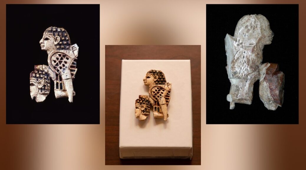
The FBI announced Thursday that the U.S. has returned a stolen Iraqi artifact that has been missing for 20 years, officials said.
The “Furniture Fitting with Sphinx Trampling a Youth” first disappeared in Baghdad in 2003.
It was recently being held at the Michael C. Carlos Museum at Emory University in Atlanta before it was returned. The Carlos Museum purchased the artifact from a third party in 2006.
The FBI said that the party used a fake record with the wrong date the artifact entered the country.
“While we realize there was no ill intent on behalf of Emory University, we are glad our agents could return a small part of history back to where it belongs in Iraq,” said Keri Farley, Special Agent in charge of FBI Atlanta.
Atlanta FBI Agents began investigating the theft last year in January. Officials with the Emory museum handed over the artifact to FBI Atlanta agents last December.
According to historians, the art dates back to the Iron Age, which happened in the 7th Century B.C. It is made of ivory, pigment and gold leaf.
FBI Agents in Washington returned a 2,700-year-old antiquity to the Iraqi Government. The artifact was displayed at the Carlos Museum at Emory University after officials were shown a fake provenance. FBI Atlanta believes the artifact was looted from Baghdad in 2003. @FBIBostonpic.twitter.com/Flun80qNj5
Officials held a ceremony Wednesday at the Iraqi Embassy in the nations capital where the special agent team presented the artifact to an Iraqi official.
The team signed documents at the ceremony where they made it the artifact’s return to Iraq official.
Agents believe the artifact was stolen during the looting of the Iraq Museum in 2003. Experts determined it was stolen from the Iraq Museum using photographs.
“The protection of the world’s cultural heritage is a priority for the U.S. Government,” said Special Agent Rafael Jimenez.
Officials said the piece was stolen with thousands of other priceless artifacts.
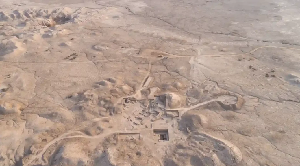
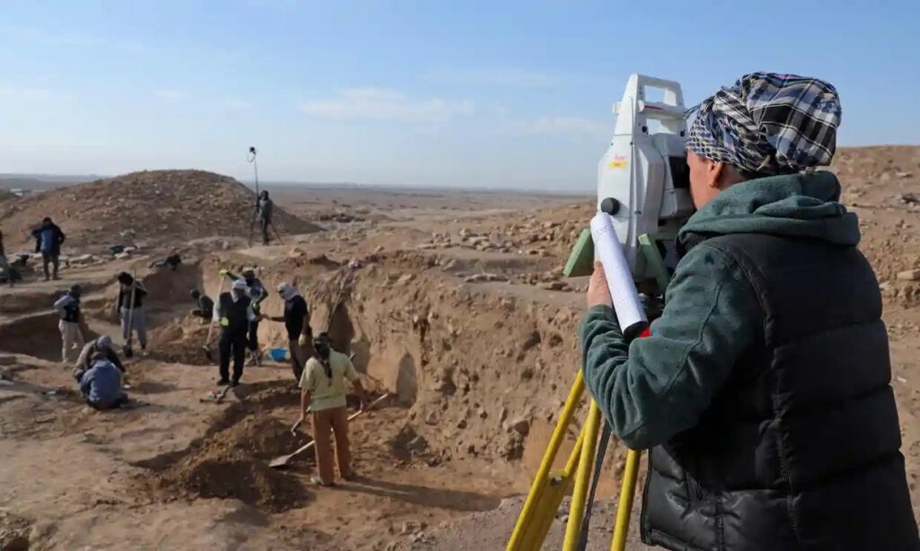
Discovery of 4,500-year-old palace in Iraq may hold key to ancient civilisation
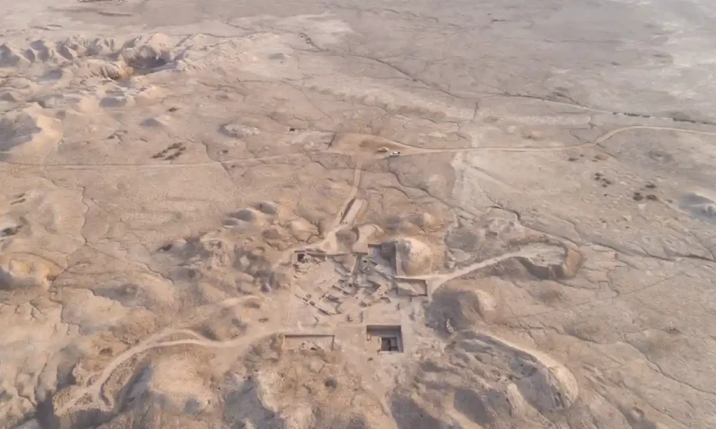
Archaeologists and workers excavate the ancient Sumerian city of Girsu, located in modern-day Tello, Iraq.
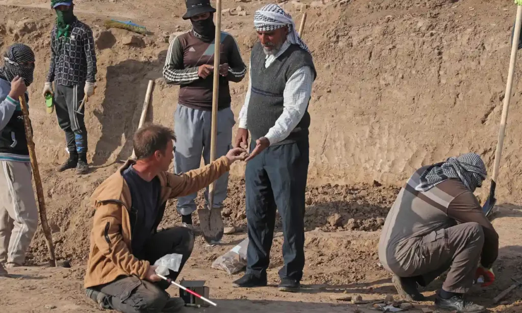
It has been described by the director of the British Museum as “one of the most fascinating sites” he has has ever visited, but the archaeologist who led the discovery of a lost Sumerian temple in the ancient city of Girsu has said he was accused of “making it up” and wasting funding.
Dr Sebastien Rey led the project that discovered the 4,500-year-old palace in modern-day Iraq – thought to hold the key to more information about one of the first known civilisations.
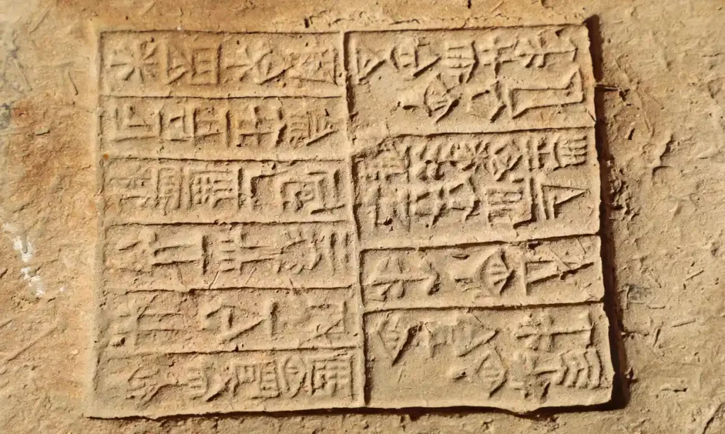
The Lord Palace of the Kings of the ancient Sumerian city Girsu – now located in Tello, southern Iraq – was discovered during fieldwork last year by British and Iraqi archaeologists. Alongside the ancient city, more than 200 cuneiform tablets were discovered, containing administrative records of the ancient city.
Archaeologists and workers excavate the ancient Sumerian city of Girsu, located in modern-day Tello, Iraq.
More than 200 cuneiform tablets were discovered at the site, containing administrative records of the ancient city.
Rey said that when he first brought up the project at international conferences no one believed him. “Everyone basically told me, ‘Oh no you’re making it up you’re wasting your time you’re wasting British Museum UK government funding’ – that’s what they were telling me,” he said.
Girsu, one of the earliest known cities in the history of humankind, was built by the ancient Sumerians, who between 3,500 and 2,000 BC invented writing, built the first cities and created the first codes of law. The ancient city was first discovered 140 years ago, but the site has been the target of looting and illegal excavations.
The discovery is the result of the Girsu Project, an archeological collaboration, established in 2015, led by the British Museum and funded by the LA-based Getty Museum.
Alongside the discovery of the palace and the tablets, the main temple dedicated to the Sumerian god, Ninĝirsu, was also identified. Before this pioneering fieldwork, its existence was known only from ancient inscriptions discovered alongside the first successful excavation of the ancient city.
The project follows the Iraqi scheme first funded by the British government in response to the destruction of important heritage sites in Iraq and Syria by Islamic State. Since its establishment, more than 70 Iraqis have been trained to conduct eight seasons of fieldwork at Girsu.
The first mud brick walls of the palace, which were discovered last year, have since been held in the Iraq Museum in Baghdad. The Sumerians inhabited the ancient eastern Mediterranean region of Mesopotamia, and were responsible for many technological advancements, including measurements of time as well as writing.
An aerial view of the excavation site in Tello, Iraq. The Sumerians inhabited the ancient eastern Mediterranean region of Mesopotamia.
The excavation site in Tello, Iraq
According to Hartwig Fischer, the director of the British Museum, the site of the ancient city in southern Iraq was “one of the most fascinating sites I’ve ever visited”.
He said: “The collaboration between the British Museum, state board of antiquities and heritage of Iraq, and the Getty represents a vital new way of building cooperative cultural heritage projects internationally. We are delighted that today’s visit could celebrate the recent discoveries that are the result of this collaboration, and continue the British Museum’s long-term commitment to the protection of the cultural heritage of Iraq, the support of innovative research, and the training of the next generation of Iraqi archaeologists at Girsu.
“While our knowledge of the Sumerian world remains limited today, the work at Girsu and the discovery of the lost palace and temple hold enormous potential for our understanding of this important civilisation, shedding light on the past and informing the future.”
The ancient Sumerians may not be as well known a civilisation as the ancient Egyptians or Greeks, but according to Dr Timothy Potts, the directory of the Getty Museum, Girsu is “probably one of the most important heritage sites in the world that very few people know about”.
The discovery is the result of the Girsu Project, an archeological collaboration established in 2015 and led by the British Museum and funded by the Getty Museum.
He added: “Through its collections, exhibitions, research and publications the Getty seeks to promote the understanding and preservation of the world’s artistic and cultural heritage.
“The ancient world has been a particular focus of the museum’s programmes at the Getty Villa, and we are therefore delighted to have partnered with the British Museum on the Girsu Project in Iraq.
“This innovative programme provides critical support for the uniquely important archaeological site of Girsu, through the training of Iraqi specialists entrusted with its development for sustainable archaeology and tourism.”
Iraq’s culture minister, Ahmed Fakak Al-Badrani, said: “The British archaeological excavations in Iraq will further unveil significant ancient eras of Mesopotamia, as it is a true testimony to the strong ties between the two countries to enhance the joint cooperation between the two countries.”
The Sumerians explainer Who were they?
The Sumerians were the inhabitants of Sumer, which is the earliest known civilisation in the historical region of Mesopotamia, located in modern-day southern Iraq. According to archaeological evidence, they built about a dozen city-states in the fourth millennium BC.
Girsu, which is located in Tello, Iraq, was first discovered 140 years ago, and was significant in that it first revealed to the world the existence of the Sumerian civilisation, as well as bringing to light some of the most vital monuments of Mesopotamian art and architecture.
What did they invent?
The Sumerians were ancient pioneers, having advanced the craft of writing, writing literature, hymns and prayers. They built the first known cities as well as creating the first known code of law. They also perfected several existing forms of technology, including the wheel, the plough and mathematics.
The epic of Gilgamesh, considered the world’s oldest surviving piece of literature, derives from five Sumerian poems.
They were also notably one of the first civilisations to brew beer, which was seen by the ancient people as a key to a healthy heart and liver.
5,000-year-old ‘tavern’ discovered on an archeological dig
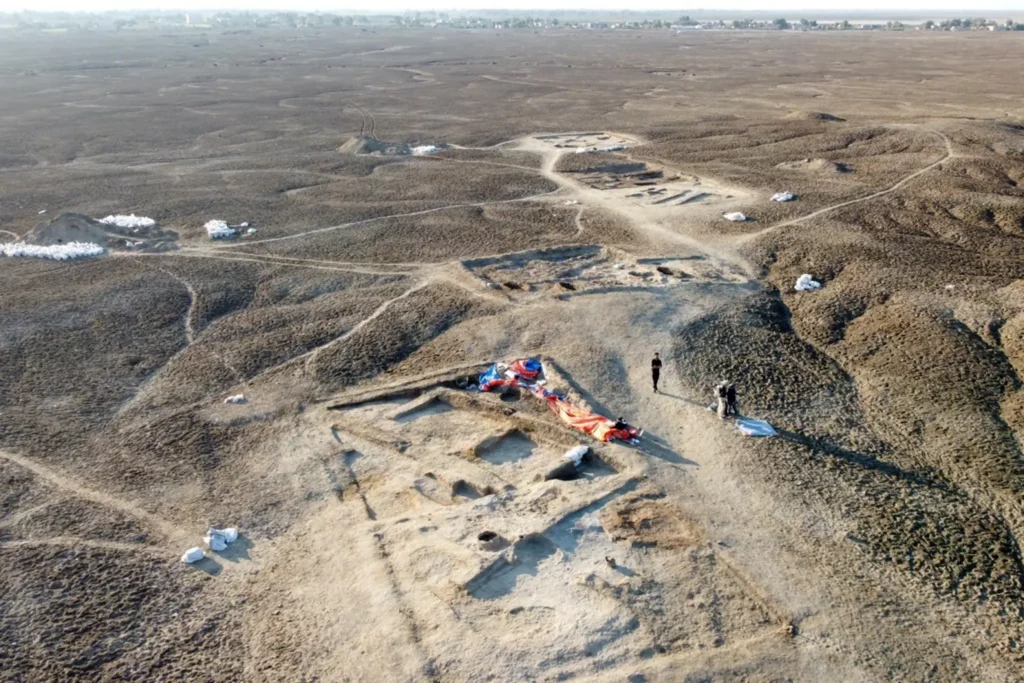
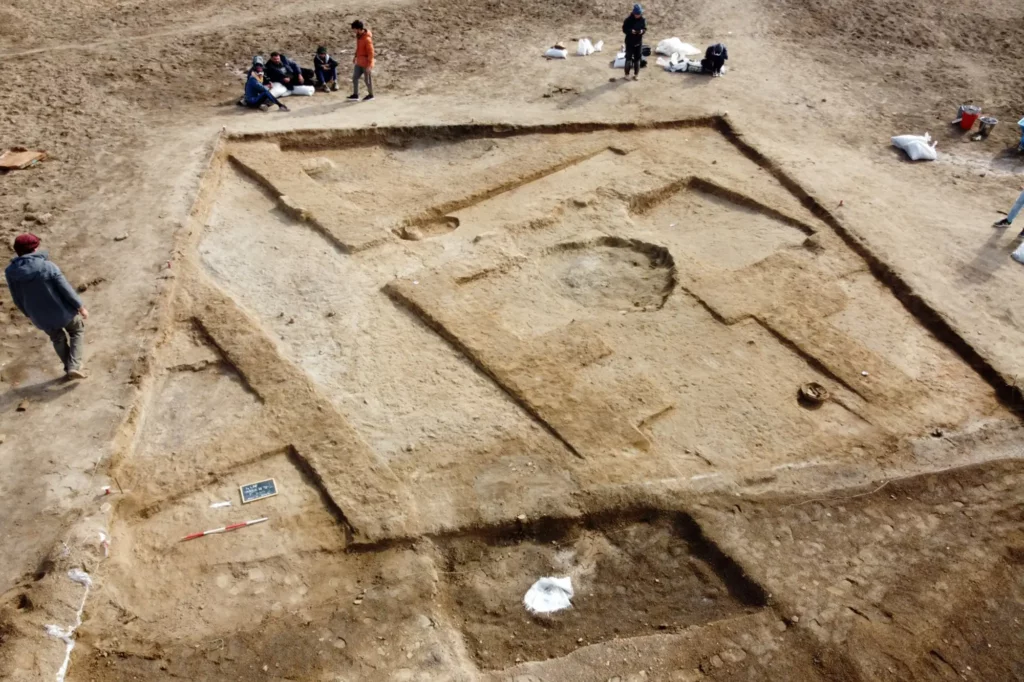
A team of researchers studying the archeological site of Lagash in southern Iraq uncovered a public eating space that dates back to 2700 B.C.
Archeologists unearthed a 5,000-year-old “tavern” in one of southwest Asia’s earliest cities.
A team of researchers studying the archeological site of Lagash in southern Iraq uncovered the public eating space, which dates back to 2700 B.C., according to the University of Pennsylvania.
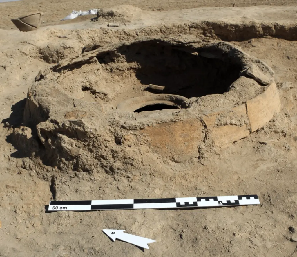
The area was replete with benches, a type of clay refrigerator referred to as a “zeer,” an oven, and storage containers, many of which still contained food.
The area was replete with benches, a type of clay refrigerator referred to as a “zeer,” an oven, and storage containers.
The area was replete with benches, a type of clay refrigerator referred to as a “zeer,” an oven, and storage containers.Lagash Archaeological Project
The tavern was discovered during an excavation in Lagash which sought items illustrating what life was like in the urban neighborhood.
“The site was of major political, economic, and religious importance,” Holly Pittman, a professor in Penn’s History of Art department, told the university. “However, we also think that Lagash was a significant population center that had ready access to fertile land and people dedicated to intensive craft production.”
“The site was of major political, economic, and religious importance,” UPenn professor Holly Pittman said.
Pittman likened the ancient metropolis to the city of Trenton, N.J., once known for being the East Coast’s center of manufacturing.
“In that way the city might have been something like Trenton,” she explained, “as in ‘Trenton makes, the world takes,’ a capital city but also an important industrial one.”
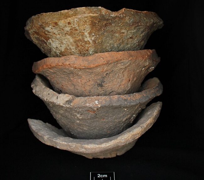
Residues in Mesopotamia’s Mass-Produced Pottery Analyzed
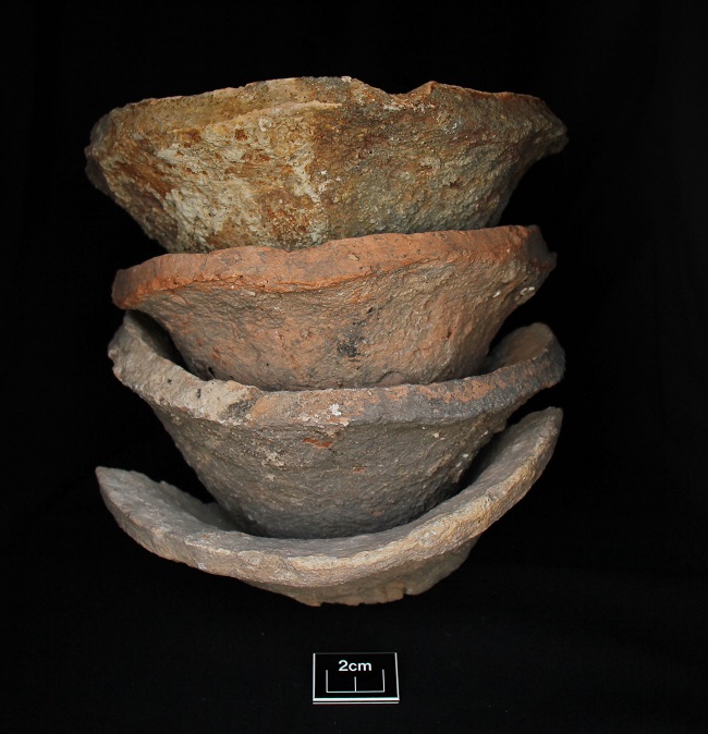
Bevelled Rim Bowls
The world’s first urban state societies developed in Mesopotamia, modern-day Iraq, some 5500 years ago. No other artefact type is more symbolic of this development than the so-called Beveled Rim Bowl (BRB), the first mass-produced ceramic bowl.
BRB function and what food(s) these bowls contained have been the subject of debate for over a century. A paper published today in The Journal of Archaeological Science: Reports shows that BRBs contained a variety of foods, but especially meat-based meals, most likely bone marrow-flavoured stews or broths.
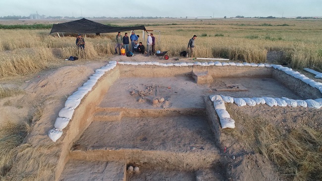
Chemical compounds and stable isotope signatures of animal fats were discovered in BRBs from the Late Chalcolithic site of Shakhi Kora located in the Upper Diyala/Sirwan River Valley of north-eastern Iraq.
An international team led by Professor Claudia Glatz of the University of Glasgow has been carrying out excavations at Shakhi Kora since 2019 as part of the Sirwan Regional Project.
Trench at Shakhi Kora where Beveled Rim Bowls were found.
BRBs are mass-produced, thick-walled, conical vessels that appear to spread from southern, lowland sites such as Uruk-Warka across northern Mesopotamia, into the Zagros foothills, and beyond. BRBs are found in their thousands at Late Chalcolithic sites, often associated with monumental structures.
Stylised BRBs appear on the earliest written documents, early cuneiform tablets, and are conventionally interpreted as ration containers used to distribute cereals or cereal-based foods to state-dependent labourers or personnel. Inherently taxable and storable, cereal grains such as wheat, emmer, and barley, have long been considered the economic backbone and main source of wealth and power for early state institutions and their elites.
However, the paper titled “Revealing invisible stews: New results of organic residue analyses of Beveled Rim Bowls from the Late Chalcolithic site of Shakhi Kora, Kurdistan Region of Iraq” states: “Our analytical results challenge traditional interpretations that see BRBs as containers of cereal-based rations and bread moulds. The presence of meat- and potentially also dairy-based foods in the Shakhi Kora vessels lends support to multi-purpose explanations and points to local processes of appropriation of vessel meaning and function.”
Dr Elsa Perruchini, Institut National du Patrimoine, Paris, and University of Glasgow, who carried out the chemical analysis, said: “The combined approach of chemical and isotopic analysis using GC-MS and GC-C-IRMS was employed to identify the source(s) of lipids extracted from ceramic sherds, with the aim of providing new insights into the function of BRBs.”
Professor Claudia Glatz, a Professor of Archaeology at the University of Glasgow and director of the Shakhi Kora excavations, said: “Our results present a significant advance in the study of early urbanism and the emergence of state intuitions.
“They demonstrate that there is significant local variation in the ways in which BRBs were used across Mesopotamia and what foods were served in them, challenging overly state-centric models of early social complexity.
“Our results point towards a great deal of local agency in the adoption and re-interpretation of the function and social symbolism of objects, that are elsewhere unambiguously associated with state institutions and specific practices.
As a result, they open up exciting new avenues of research on the role of food and foodways in the development, negotiation, and possible rejection of the early state at the regional and local level.”
Professor Jaime Toney, Professor of Environmental and Climate Science at the University’s School of Geographical and Earth Sciences, said: “We have been collaborating closely with Claudia and her team for several years to minimise contamination during the collection of vessels from archaeological sites and it is fascinating to see this pay off with the analysis of fossil residues and the stable isotope analysis clearly indicate that they once held animal fats.”
Archaeologists unearth ancient Sumerian riverboat in Iraq
All that’s left today of an ancient boat discovered in 2018 in what was formerly Uruk is the bitumen, black tar that once coated its framework of reeds, palm leaves, or wood. That fragile organic material is long gone, leaving behind only ghostly imprints in the bitumen.
But there’s enough left for archaeologists to tell that in its heyday, the boat would have been a relatively slender craft—7 meters long and about 1.5 meters wide—well-suited to navigating the rivers and canals of ancient Sumer.
Archaeologists found the boat in an area that, 4,000 years ago, would have been the bustling hinterlands of the largest city in the world: Uruk.
Founded in 5000 BCE from the merger of two smaller settlements on the bank of the Euphrates River, Uruk was one of the world’s first major cities and possibly even the birthplace of the world’s first writing (the oldest known writing samples in the world are tablets from Uruk).
The Sumerian King List claims the legendary hero-king, Gilgamesh, ruled from his seat at Uruk in the 2600s BCE, which is not long before the recently excavated boat was built, sailed, and sank.
At its height around 3000 BCE, Uruk boasted 40,000 residents in the city, with a total population of about 80,000 or 90,000 people in the surrounding hinterlands.
The area outside the city boasted smaller communities, farms, ancient manufacturing workshops, and networks of canals. Uruk was beginning its long, slow decline by 2000 BCE, around the time our boat was built.
The outline of the boat’s hull is just visible from the air in this photo.
Based on its resting place in layers of silty sediment, it seems that the boat sank in a river, which swiftly buried it and preserved it for the next 4,000 years. That ancient river has long since silted up, but a few years ago, it began to yield at least one long-held secret: erosion revealed the outline of the boat, which archaeologists documented with digital photos and measurements in 2018.
At the time, archaeologists from the Iraqi State Board of Antiquities and the German Archaeological Institute chose to leave the boat buried, where the ancient river’s silt could continue to protect it from decay and damage.
But over the last few years, it became clear that the boat was no longer safe in its resting place. Erosion in the area had picked up the pace, and parts of the boat’s structure were sticking out above the surface.
“Traffic passing close to the site of the discovery was an acute threat to the preservation of the boat,” explained the German Archaeological Institute in a press release.
That led to a rescue mission in which archaeologists had to balance urgency with delicacy as they carefully excavated the boat from its once-watery, now-silty grave.
They encased the boat and a block of the surrounding sediment in a shell made of clay and gypsum plaster to make it easier to safely unearth and move it.
Now, 4,000 years after setting out on its ill-fated final journey, the boat has a new homeport: the Iraq Museum in Baghdad, where archaeologists will study and conserve what’s left of the hull and eventually display it to the public.
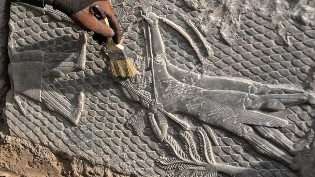
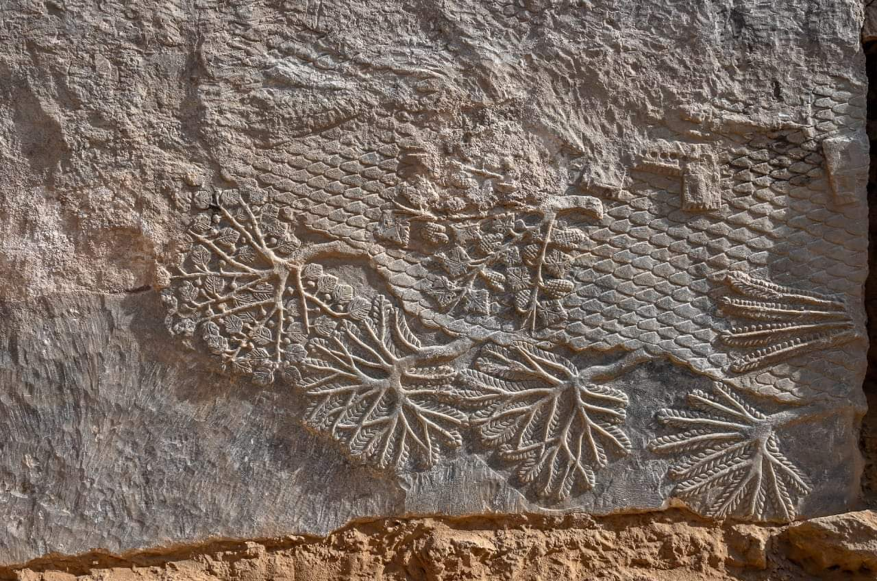
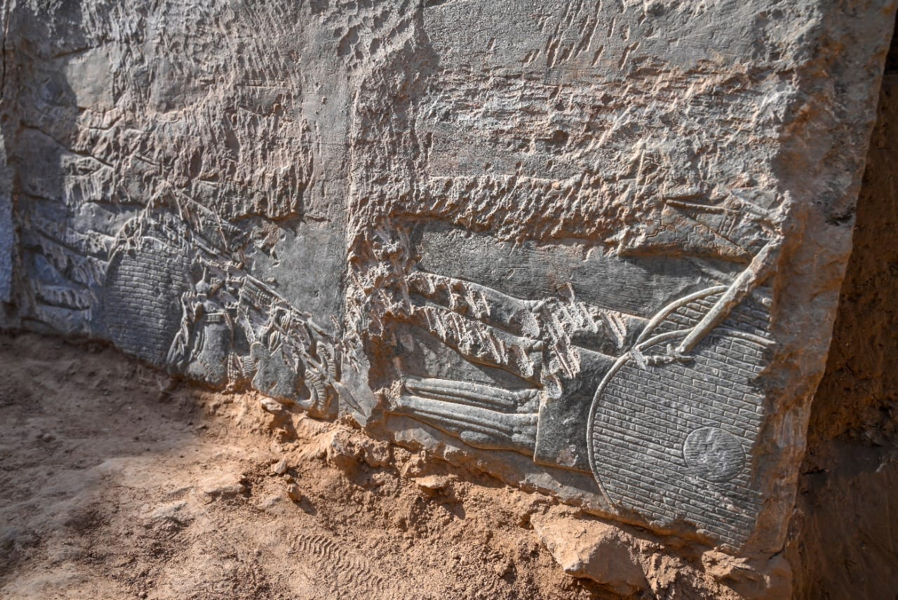
Rare 2,700-Year-Old Stone Carvings Discovered in Iraq
An Iraqi worker excavates a rock-carving relief recently found at the Mashki Gate, one of the monumental gates to the ancient Assyrian city of Nineveh, on the outskirts of what is today the northern Iraqi city of Mosul.
Archaeologists in Iraq have unearthed 2,700-year-old stone carvings that were chiselled into a previously undiscovered section of the Mashki Gate, an iconic structure in what was once the ancient Assyrian capital city of Nineveh.
The eight intricately carved marble bas-reliefs, which depict war scenes, grapevines, palm trees and other motifs, were found in what is now Mosul, during a project to restore the gate after Islamic State group militants destroyed it.
Experts believe that the decorative gate dates back to King Sennacherib, who ruled the Assyrian empire from 705 B.C. to 681 B.C., according to a statement from the Iraqi Council of Antiquities and Heritage.
During his reign, King Sennacherib moved the Assyrian capital to Nineveh where he became well known for his vast military campaigns, according to BBC News.
“We believe that these carvings were moved from the palace of Sennacherib and reused by the grandson of the king to renovate the gate of Mashki and to enlarge the guard room,” Fadel Mohammed Khodr, head of the Iraqi archaeological team, told Al Jazeera.
Because much of the gate was buried underground due to the way it was oriented during its original construction, the only portions that archaeologists could salvage were under the soil.
“Only the part buried underground has retained its carvings,” Khodr said.
In 2016, militants from IS (also called ISIS, ISIL or Daesh) destroyed the iconic gate with a bulldozer.
The Swiss-based International Alliance for the Protection of Heritage in Conflict Areas is working with Iraqi authorities as well as archaeologists from the University of Pennsylvania and Mosul University on the restoration of the gate.
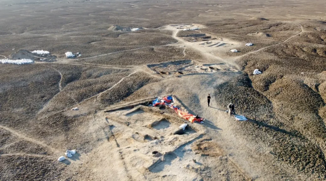
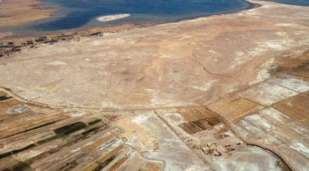
Drone photos reveal an early Mesopotamian city made of marsh islands
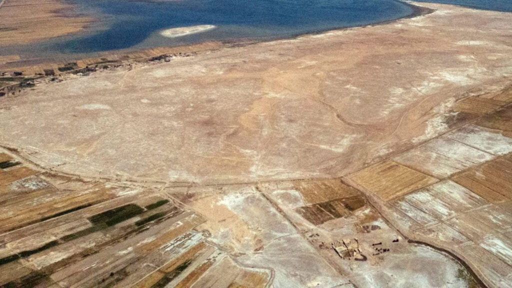
New remote-sensing studies at southern Iraq’s massive Tell al-Hiba site, shown here from the air, support an emerging view that an ancient city there largely consisted of four marsh islands.
A ground-penetrating eye in the sky has helped to rehydrate an ancient southern Mesopotamian city, tagging it as what amounted to a Venice of the Fertile Crescent. Identifying the watery nature of this early metropolis has important implications for how urban life flourished nearly 5,000 years ago between the Tigris and Euphrates rivers, where modern-day Iraq lies.
Remote-sensing data, mostly gathered by a specially equipped drone, indicate that a vast urban settlement called Lagash largely consisted of four marsh islands connected by waterways, says anthropological archaeologist Emily Hammer of the University of Pennsylvania. These findings add crucial details to an emerging view that southern Mesopotamian cities did not, as traditionally thought, expand outward from temple and administrative districts into irrigated farmlands that were encircled by a single city wall, Hammer reports in the December Journal of Anthropological Archaeology.
“There could have been multiple evolving ways for Lagash to be a city of marsh islands as human occupation and environmental change reshaped the landscape,” Hammer says.
Because Lagash had no geographical or ritual center, each city sector developed distinctive economic practices on an individual marsh island, much like the later Italian city of Venice, she suspects. For instance, waterways or canals crisscrossed one marsh island, where fishing and collection of reeds for construction may have predominated.
Two other Lagash marsh islands display evidence of having been bordered by gated walls that enclosed carefully laid out city streets and areas with large kilns, suggesting these sectors were built in stages and may have been the first to be settled. Crop growing and activities such as pottery making may have occurred there.
Drone photographs of what were probably harbors on each marsh island suggest that boat travel connected city sectors. Remains of what may have been footbridges appear in and adjacent to waterways between marsh islands, a possibility that further excavations can explore.
Lagash, which formed the core of one of the world’s earliest states, was founded between about 4,900 and 4,600 years ago. Residents abandoned the site, now known as Tell al-Hiba, around 3,600 years ago, past digs show. It was first excavated more than 40 years ago.
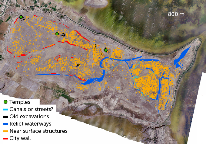
Hidden city
Drone photos taken across a massive site in southern Iraq revealed that buried structures, shown in yellow, from the ancient Mesopotamian city of Lagash clustered in four sectors that had probably been marsh islands. Walls, shown in red, surrounded two large sectors. Now-dry waterways, shown in dark blue, connected sectors and crisscrossed one sector, far right.
Composite map of Lagash based on remote-sensing data
E. HAMMER/J. ANTHROPOLOGICAL ARCHAEOLOGY 2022
Previous analyses of the timing of ancient wetlands expansions in southern Iraq conducted by anthropological archaeologist Jennifer Pournelle of the University of South Carolina in Columbia indicated that Lagash and other southern Mesopotamian cities were built on raised mounds in marshes. Based on satellite images, archaeologist Elizabeth Stone of Stony Brook University in New York has proposed that Lagash consisted of around 33 marsh islands, many of them quite small.
Drone photos provided a more detailed look at Lagash’s buried structures than possible with satellite images, Hammer says. Guided by initial remote-sensing data gathered from ground level, a drone spent six weeks in 2019 taking high-resolution photographs of much of the site’s surface. Soil moisture and salt absorption from recent heavy rains helped the drone’s technology detect remnants of buildings, walls, streets, waterways and other city features buried near ground level.
Drone data enabled Hammer to narrow down densely inhabited parts of the ancient city to three islands, she says. A possibility exists that those islands were part of delta channels extending toward the Persian Gulf. A smaller, fourth island was dominated by a large temple.
Hammer’s drone probe of Lagash “confirms the idea of settled islands interconnected by watercourses,” says University of Chicago archaeologist Augusta McMahon, one of three co–field directors of ongoing excavations at the site.
Drone evidence of contrasting neighborhoods on different marsh islands, some looking planned and others more haphazardly arranged, reflect waves of immigration into Lagash between around 4,600 and 4,350 years ago, McMahon suggests. Excavated material indicates that new arrivals included residents of nearby and distant villages, mobile herders looking to settle down and slave laborers captured from neighboring city-states.
Dense clusters of residences and other buildings across much of Lagash suggest that tens of thousands of people lived there during its heyday, Hammer says. At that time, the city covered an estimated 4 to 6 square kilometers, nearly the area of Chicago.
It’s unclear whether northern Mesopotamian cities from around 6,000 years ago, which were not located in marshes, contained separate city sectors (SN: 2/5/08). But Lagash and other southern Mesopotamian cities likely exploited water transport and trade among closely spaced settlements, enabling unprecedented growth, says archaeologist Guillermo Algaze of the University of California, San Diego.
Lagash stands out as an early southern Mesopotamian city frozen in time, Hammer says. Nearby cities continued to be inhabited for a thousand years or more after Lagash’s abandonment, when the region had become less watery and sectors of longer-lasting cities had expanded and merged. At Lagash, “we have a rare opportunity to see what other ancient cities in the region looked like earlier in time,” Hammer says.
The rediscovery of Noah a 6,500-year-old skeleton, who survived a great flood
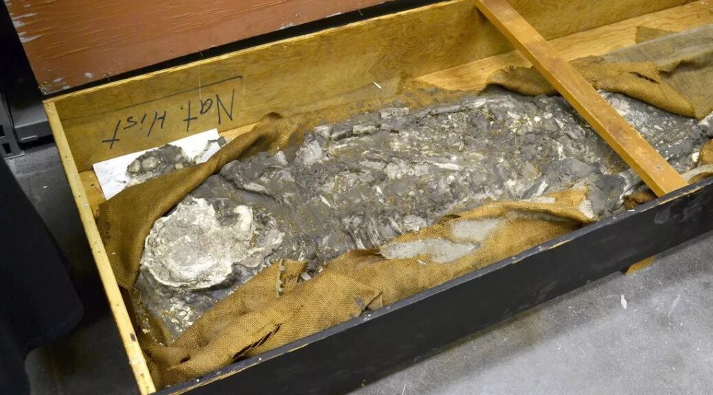
A 6,500-year-old skeleton was unearthed at the Ur site in Iraq. Here, the skeleton was coated in wax in the field and lifted whole along with surrounding dirt.
Scientists at the Penn Museum in Philadelphia are quite literally cleaning the skeletons out of their closets. Museum staff recently rediscovered a 6,500-year- old human skeleton that’s been boxed up in the basement for 85 years.
Tucked away in a storeroom, the wooden box had no identifying numbers or catalogue cards. But a recent effort to digitalize some of the museum’s old records brought forth new information about the mysterious box’s history and the skeleton, nicknamed “Noah,” inside.
The human remains inside the box were originally unearthed between 1929 and 1930 at the site of Ur in modern-day Iraq by Sir Leonard Woolley and his team of archaeologists from the Penn and British Museums, according to the records.
Woolley’s excavation is best known for uncovering the famous Mesopotamian “royal cemetery,” which included hundreds of graves and 16 tombsladen with cultural artefacts. But the archaeologist and his team also discovered graves that preceded Ur’s royal burial ground by about 2,000 years.
A lightweight plaster mixture is placed over the covered skeleton, the 6,500-year-old human remains discovered at the Ur site in Iraq, in order to protect it during shipping. The silt is already being cut away under the skeleton to make room for the carrying board.
In a flood plain, nearly 50 feet (15 meters) below the surface of the site of Ur, the team found 48 graves dating back to the Ubaid period, roughly 5500 B.C. to 4000 B.C.
Though remains from this period were extremely rare even in 1929, Woolley decided to recover only one skeleton from the site. He coated the bones and surrounding soil in wax, boxed them up and shipped them to London, then Philadelphia.
A set of lists outlined where the artefacts from the 1929 to 1930 dig were headed — while half of the artefacts remained in Iraq, the others were split between London and Philadelphia. One of the lists stated that the Penn Museum was to receive a tray of mud from the excavation, as well as two skeletons.
But when William Hafford, the project manager responsible for digitalizing the museum’s records, saw the list, he was puzzled. One of the two skeletons on the list was nowhere to be found.
Further research into the museum’s database revealed the unidentified skeleton had been recorded as “not accounted for” as of 1990. To get to the bottom of this mystery, Hafford began exploring the extensive records left by Woolley himself.
After locating additional information, including images of the missing skeleton, Hafford approached Janet Monge, the Penn Museum’s curator of physical anthropology. But Monge, like Hafford, had never seen the skeleton before.
That’s when Monge remembered the mysterious box in the basement.
When Monge opened the box later that day, she said it was clear the human remains inside were the same ones listed as being packed up and shipped by Woolley.
The skeleton, she said, likely belonged to a male, 50 years or older, who would have stood somewhere between 5 feet 8 inches (173 centimetres) to 5 feet 10 inches (178 cm) tall.
Penn Museum researchers have nicknamed the re-discovered skeleton “Noah,” because he is believed to have lived after what archaeological data suggests was a massive flood at the original site of Ur.
New scientific techniques that weren’t yet available in Woolley’s time could help scientists at the Penn Museum determine much more about the time period to which these ancient remains belonged, including diet, ancestral origins, trauma, stress and diseases.