Category Archives: SOUTH AMERICA

Unique tombs wrapped in high-quality fabrics and painted bodies were discovered at monumental temple in Peru

Unique tombs wrapped in high-quality fabrics and painted bodies were discovered at a monumental temple in Peru

Unique tombs wrapped in high-quality fabrics and painted bodies were discovered at the monumental temple in Peru.

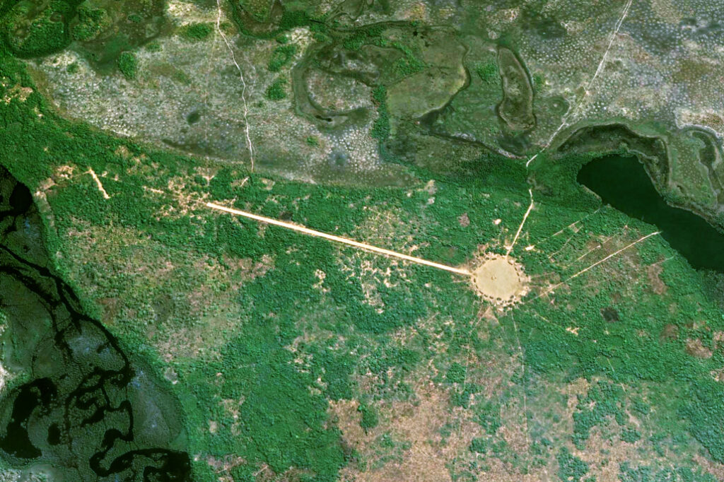
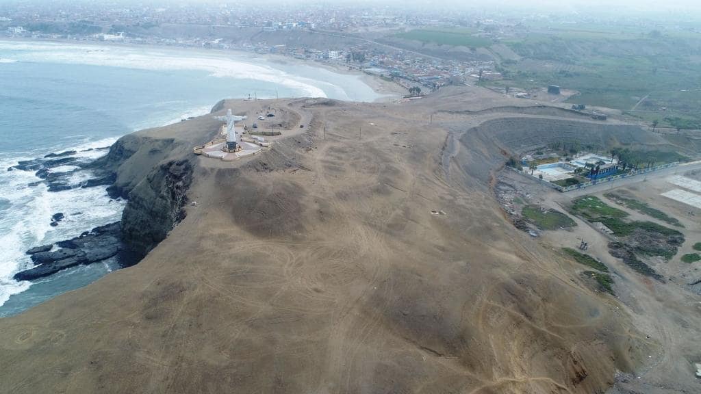
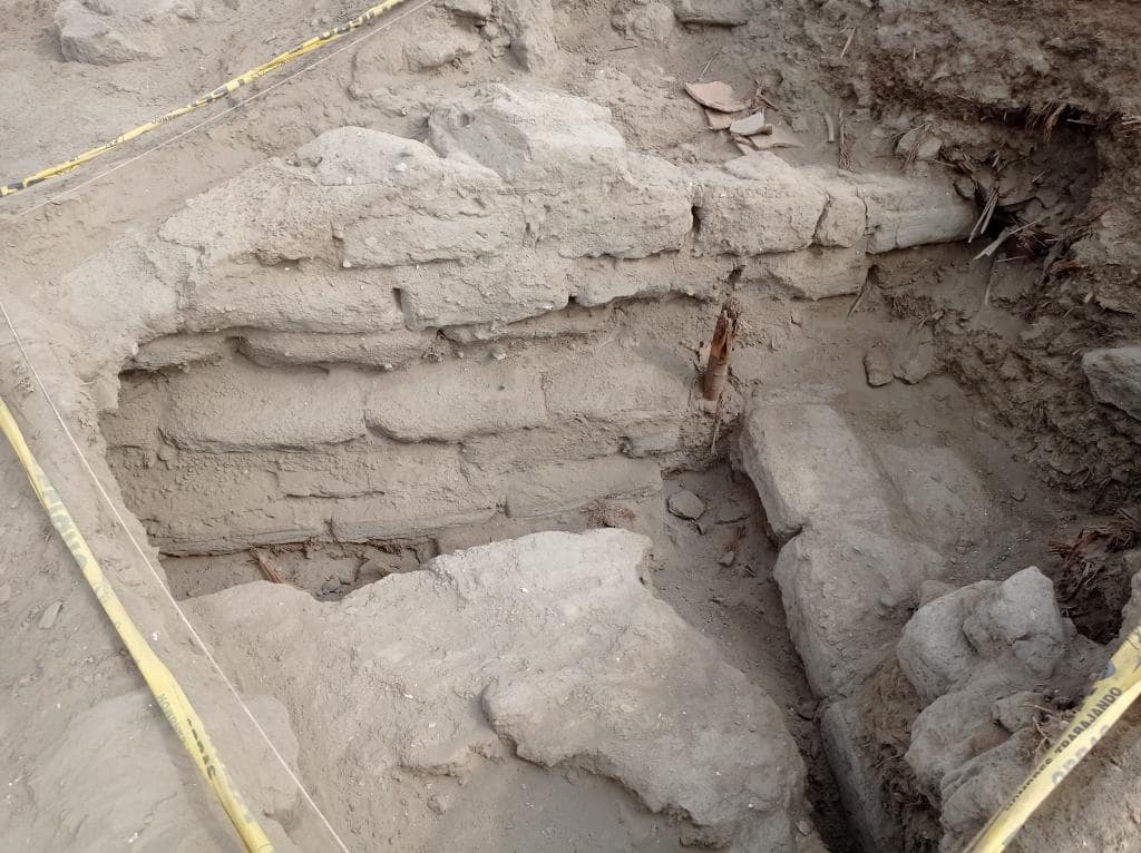
Located on the Cerro Colorado hill near the city of Barranca, Peru, four mysterious mounds were identified as spots with potential archaeological significance. The mounds were later revealed to contain human remains and the remnants of a temple structure.

Excavations are being carried out by archaeologists from the Jagiellonian University and St Mark’s University as part of the Programa de Investigacion “Los valles de Barranca” project.

The project to investigate the area began in 2022, and the results were announced in February of this year, according to Nauka W Polsce.

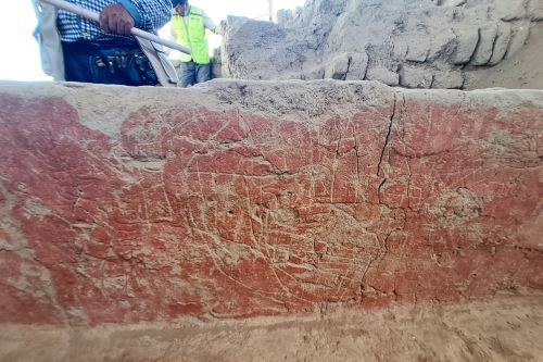
Human burials and monumental architecture made of dried bricks and stone blocks were discovered during research on two of the mounds. This has resulted in a large-scale excavation of the site, where the project has discovered destroyed burials in the form of burial bundles, which were placed within the ruins of a temple complex made of dried brick.

Dyed fabric found in a tomb at the top of the site, dated 772 -989 AD

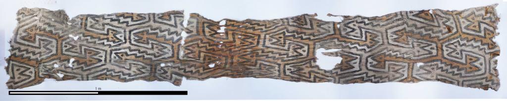
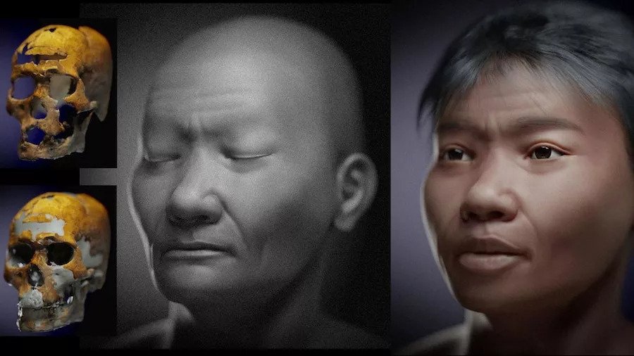
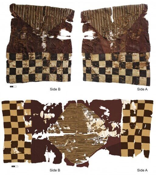
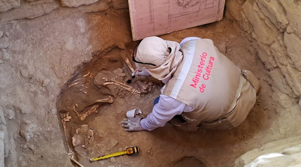
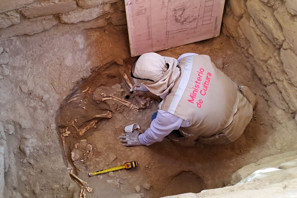
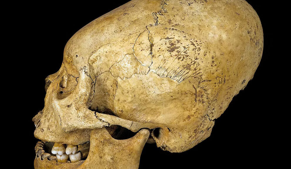
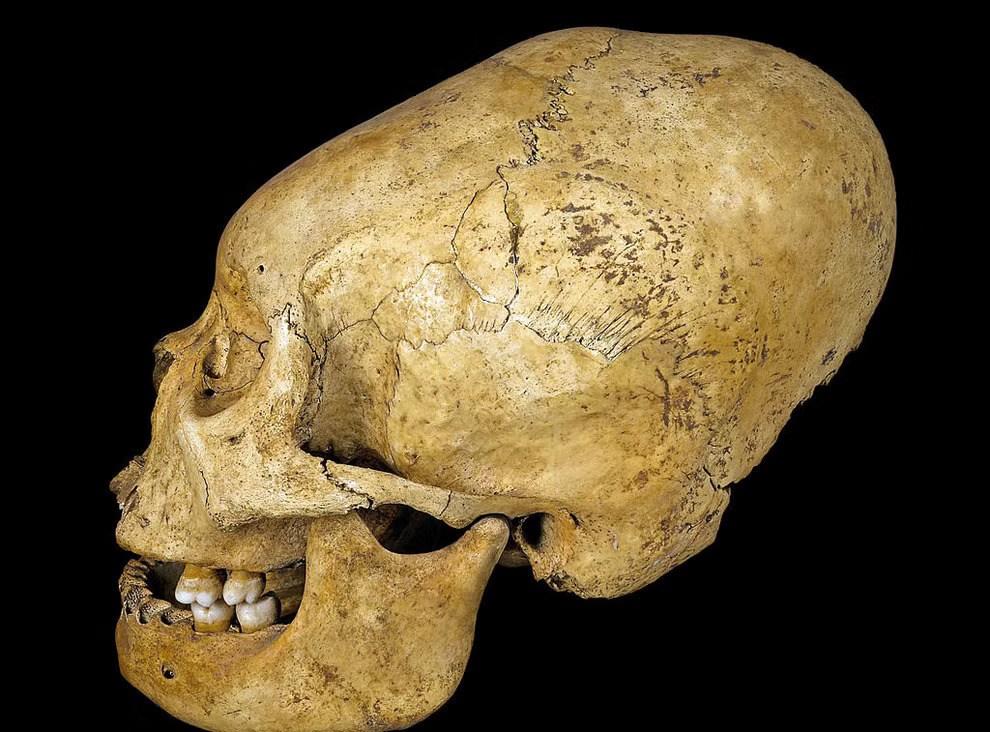
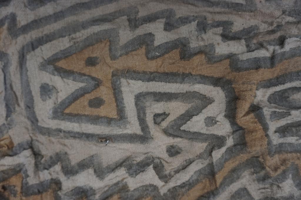
The remains of a young boy whose skull was intentionally deformed are found in one of the destroyed burials. He was originally buried with decorated textiles, indicating that he came from a high-status family. The fabric was three meters long and decorated with totally unique zoomorphic representations.

Bioarchaeologist, Łukasz Majchrzak, said “One of them (fabrics), 3 meters long, was decorated with zoomorphic representations and is unique – similar fabrics have not been found in the entire Andes so far,”

The construction of the temple complex was dated by physicochemical analysis and carbon dating of organic remains to between 2500 and 2200 BC, whereas the same method used to date the burials indicates that they were interred between AD 772 and 989.

Dyed fabric detail.

“Andeans used to set up necropolises in abandoned places of worship. This was also the case here because the graves were dug into structures that were several thousand years older,” added Majchrzak.

The grass and mortar mixture that was used to bind the blocks that made up the small pyramid was sampled for the structure’s dating. Settlements with imposing architecture were built in the Andes during the third millennium BC, and agriculture spread as a result of interactions with communities residing in the Amazon.

A wall made of bricks at the top of the site.

The examined graves date from the Wari Empire’s reign over the region. Castillo de Huarmey, one of the most important sites of this culture, is only 70 kilometers north of Barranca.

Reconstruction of 9,600-Year-Old Skull Completed in Brazil

Reconstruction of 9,600-Year-Old Skull Completed in Brazil

In 1997, archaeologists unearthed a skeleton buried in the fetal position at Toca dos Coqueiros, an archaeological site in Brazil’s Serra da Capivara National Park.

Reconstruction of 9,600-Year-Old Skull Completed in Brazil
Researchers created two facial approximations of Zuzu using photogrammetry of the skull.

Based on the size and shape of the skull, they identified the remains as female and named the skeleton Zuzu. But that classification has remained steeped in controversy, with many researchers claiming the deceased was actually male. 

Now, a new facial approximation of the 9,600-year-old skull may help put this debate to rest. 

Last year, researchers took dozens of photos from different angles of the skull, which is on display at the Museum of Nature in Piauí, Brazil. Using photogrammetry, they digitally stitched the 57 photographs together to create a virtual 3D model of the skull “in order to reveal the face of that figure so mysterious and so important to Brazilian history,” the researchers wrote in their study, published Jan. 25.

“Trying to recover the appearance that an individual had in life thousands of years ago is a way to bring them to the present day, bringing them closer to the public,” first author Moacir Elias Santos, an archaeologist with the Ciro Flamarion Cardoso Archaeology Museum in Brazil, told Live Science in an email. “The main interest was to be able to glimpse the face of Zuzu, whose skeleton is one of the most important finds in the Serra da Capivara National Park region.”

To inform their work, they used computerized tomography (CT scans) from living virtual donors and applied that information to “adjust the structure of the skull” by including tissue thickness markers, study co-author Cícero Moraes, a Brazilian graphics expert, told Live Science in an email.

“[We] adjust the structure of the skull to transform the donor’s skull into a volume almost equal to Zuzu’s skull,” Moraes said. “When we do this, the soft tissue follows this deformation/adaptation and results in a face that is expected, [and] compatible with Zuzu in life.”

The researchers created two results, both depicting a young man with a broad nose and lips. One of the approximations included hair and eyebrows based on information provided by the virtual donors, and the other featured Zuzu with closed eyes and without hair.

Because the digital face was “slightly emaciated,” the researchers retracted the lower jaw to match a gap that came from some missing teeth, according to the study.

“Although the skull has affinity with an Asian population, among individuals of such ancestry there are a large number of structural differences, which are circumvented by closing the eyelids,” the researchers wrote in the study.

“The image was also rendered in grayscale (black and white) as there is no accurate information about the skin color. Therefore, such an image would be the closest to what the real face could be.” 

“The most interesting thing when looking at Zuzu’s skull is having an idea of what he would have looked like in life,” Santos said. “It is a reunion with one of the oldest ancestors of our country.”

Rare Inca Tunic Unearthed in Chile

Rare Inca Tunic Unearthed in Chile

Unku found in Caleta Vitor Bay. Top: sides A and B from the wearer’s point of view (photographs by Paola Salgado); bottom: illustration of the tapestry tunic from the weaver’s position and viewpoint (illustration by Paola Salgado).

A new study co-authored by a George Washington University research professor examines the Inka Empire’s (also known as the Incan Empire and the Inca Empire) instruments of culture and control through a well-preserved article of clothing discovered in a centuries-old Chilean cemetery.

Researchers excavating the burial site along Caleta Vítor Bay in northern Chile found a tunic, or unku (see above), which would have been worn by a man who commanded respect and prestige in the Inka Empire.

Unkus were largely standardized attire meeting technical and stylistic specifications imposed by imperial authorities.

The Caleta Vítor unku, however, goes beyond the strict mandates handed down by Inka leaders.

While the artisans who fashioned this unku clearly adhered to imperial design standards, they also included subtle cultural tributes unique to their provincial homeland.

Whoever wove the Caleta Vítor unku lived hundreds of miles south of the Inka capital of Cusco in an area absorbed into the Inka Empire in the late 15th century.

The weaver employed the techniques and unique style and imagery of an indigenous culture that existed long before the Inka conquest, creating a tangible symbol of provincial life in pre-colonial South America.

“It represents a study of a rare example of an excavated Inka unku tunic, whose context and technical features are providing an unprecedented understanding of imperial Inka influence in the provinces,” Jeffrey Splitstoser, an assistant research professor of anthropology at GW and a co-author of the study, said.

The paper is published in the journal PLOS ONE.

This Circular Island in Argentina Not Only Floats, But Also Rotates Constantly

This Circular Island in Argentina Not Only Floats, But Also Rotates Constantly

This Circular Island in Argentina Not Only Floats, But Also Rotates Constantly

South America’s second longest river, the Paraná, which has a length of 4,880 kilometers, flows through three countries: Brazil, Paraguay and Argentina. 4,880 kilometers is no short distance – it gives plenty of opportunities for discovering amazing things.

In the case of the Paraná, one of the most exciting discoveries was made at its delta: an island 120 meters in diameter, almost completely circular in shape, and floating freely on its axis.

So-called floating islands are found in many parts of the world, including Finland, Turkey, Italy, Serbia, the Danube Delta in Romania and Ukraine, Lake Titicaca on the border between Bolivia and Peru, Lake Loktak in India, and many other places. However, this Argentinean island stands out from the rest because of its shape and its continuous rotation.

Floating islands are usually based on large roots that have ended up in the water and on which some other aquatic plant starts to grow. Plants found along the shoreline of wetlands often spread inwards from the shore, to where their roots no longer reach the deeper parts of the lake or river. When this happens, they use the oxygen in their root mass as buoyancy and the surrounding vegetation as support to survive in the water.

However, occasional violent storms can tear away these floating islands of vegetation, which can then be carried back and forth across the lake by the wind. Usually, they find calm somewhere again along the shoreline or break up completely due to stronger winds.

In some cases, however, the floating islands may persist for longer periods. In the aforementioned Lake Titicaca, for example, a group of 120 islands has been taken by an indigenous tribe, the Uru, but these islands require constant maintenance to survive.

The unusual piece of land known only as “El Ojo” (Eye Island) was formed by some very special currents that keep the circular island in constant motion. As it collides with its surroundings, it repeatedly detaches the muddy bits that might have given it a rest.

The island itself was just recently discovered by Argentine filmmaker Sergio Neuspiller, who was looking for a location for one of his films about paranormal phenomena when he came across the island in the delta. He didn’t know at the time that the piece of land was spinning around slowly – he only found out when he returned to the site shortly afterwards and was surprised to see that the island had moved elsewhere in the meantime.

The movement can also be seen in Google satellite images taken at different times.

The recordings also prove that the island has been in the Paraná delta for almost 20 years, since 2003.

Neuspiller got preoccupied with the question of the rotating island later, around 2016, when he, together with an engineer from New York, started raising funds to find out what’s behind the phenomenon.

They wanted to collect 50,000 dollars to solve the mystery, but since not even a fifth of the amount came together, their investigation, which would have also covered the supernatural, was not completed. What a shame.

Study Investigates Source of Amazon’s “Dark Earth”

Study Investigates Source of Amazon’s “Dark Earth”

Indigenous people in the Amazon may have been deliberately creating fertile soil for farming for thousands of years.

Study Investigates Source of Amazon’s “Dark Earth”
Growing crops in the Amazon’s nutrient-poor dirt is tough. In a tradition that may be thousands of years old, indigenous Kuikuro people in Brazil overcome this issue by making their own fertile soil from ash, food scraps and controlled burns.

At archaeological sites across the Amazon River basin, mysterious patches of unusually fertile soil dot the landscape. Scientists have long debated the origin of this “dark earth,” which is darker in color than surrounding soils and richer in carbon.

Now, researchers have shown that indigenous Kuikuro people in southeastern Brazil intentionally create similar soil around their villages. The finding, presented December 16 at the American Geophysical Union meeting, adds evidence to the idea that long-ago Amazonians deliberately manufactured such soil too.

The fact that Kuikuro people make dark earth today is a “pretty strong argument” that people were also making it in the past, says Paul Baker, a geochemist at Duke University who was not involved in the research.

In doing so, these early inhabitants may have inadvertently stored massive quantities of carbon in the soil, says study presenter Taylor Perron, an earth scientist at MIT. The technique, he says, could provide a blueprint for developing methods of sustainably locking atmospheric carbon in tropical soils, helping fight climate change.   

Indigenous people have altered the Amazon for thousands of years

The Western world has long viewed the Amazon as a vast wilderness that was relatively untouched before Europeans showed up. At the center of this argument is the idea that the Amazon’s soil, which is poor in nutrients like other tropical soils, precluded its inhabitants from developing agriculture at a scale required to support complex societies.     

But a slew of archeological finds in recent decades — including the discovery of ancient urban centers in Amazonian areas of modern-day Bolivia — has revealed that people were actively shaping the Amazon for thousands of years before the arrival of Europeans (SN: 5/25/22).

Most scientists today agree that the presence of dark earth near archaeological sites means that long-ago Amazonians used this soil to grow crops. But while some archaeologists argue that people purposely made the soil, others contend that dark earth was laid down through geologic processes.

Perron and colleagues reviewed interviews of Kuikuro people conducted by a Kuikuro filmmaker in 2018. Those conversations revealed that Kuikuro villagers actively make dark earth — eegepe in Kuikuro — using ash, food scraps and controlled burns.

“When you plant where there is no eegepe, the soil is weak,” explained elder Kanu Kuikuro in one of the interviews. “That is why we throw the ash, manioc peelings and manioc pulp.”

The researchers collected soil samples from around Kuikuro villages and archaeological sites in Brazil’s Xingu River basin. The team found “striking similarities” between dark earth samples from ancient and modern sites, Perron says. Both were far less acidic than surrounding soils — probably thanks to the neutralizing effect of ash — and contained higher levels of plant-friendly nutrients.

Soil that bears a striking resemblance to dark earth can be found in and around Kuikuro villages (one seen here from above) in southeastern Brazil.

Dark earth could store a lot of carbon in the Amazon

These analyses also revealed that dark earth holds twice the amount of carbon as surrounding soils on average. Infrared scans of the Xingu region suggest that the area is pockmarked with dark earth, and that as much as roughly 9 megatons of carbon — the annual carbon emissions of a small, industrialized country — may have gone unaccounted in the area, the researchers reported at the meeting.  

This number, while preliminary, could inflate to roughly the annual carbon emissions of the United States when all dark earth across the Amazon is taken into consideration, Perron says.

Figuring out how much carbon is actually stored in the Amazon could help improve climate simulations. But the researchers’ estimates are a “huge extrapolation from a very small dataset,” Baker cautions — a sentiment echoed by Perron.

Pinning down the true value of carbon stored in the Amazon’s dark earth will require more data, says Antoinette WinklerPrins, a geographer at Johns Hopkins University who was not involved in the study. Still, the research has “profound implications of the past and future” of the Amazon, she says.

For one thing, the technique highlights how ancient people were able to thrive in the Amazon by developing sustainable farming that doubled as a carbon-sequestration technique. With more and more greenhouse gases entering the atmosphere, making dark earth — or something like it — could be a method of mitigating climate change while supporting agriculture in the tropics.

“People in the ancient past figured out a way to store lots of carbon for hundreds or even thousands of years,” Perron says. “Maybe we can learn something from that.”

Possible Funerary Structures Uncovered at Peru’s Huaca Bandera

Possible Funerary Structures Uncovered at Peru’s Huaca Bandera

Possible Funerary Structures Uncovered at Peru’s Huaca Bandera

Culture Ministry’s researchers digging at Huaca Bandera —located in the district of Pacora in Lambayeque region— have found architectural structures of the Mochica elite, as well as human remains linked to important ancestral iconography.

The head of the Decentralized Culture Directorate (DDC) in Lambayeque, Julio Fernandez, reported that a new investment phase of the project ‘Recovery of Walled Complex 2 in the Central Sector of Archaeological Complex Huaca Bandera’ was successfully completed for S/624,921 (about US$163,335).

These resources created 95 jobs for professional and working-class people, mostly people from the aforementioned Lambayeque’s district.

According to Fernandez, the work at Huaca Bandera included archaeological research studies —both field and desktop— preventive conservation practices, archaeometry research, and dating using radiocarbon techniques.

Walled Complex

Archaeologist Manuel Curo, the project’s director, commented that at this stage the team continued to study Walled Complex 2 —one of the areas used by ruling elites in the lower valley of La Leche-Motupe in 850 B.C. during the transition from the Mochica to Lambayeque periods.

Moreover, the specialist explained that it has been possible to document the design of the pyramidal platform at Walled Complex 2 and its main architectural elements, particularly those found in its upper platform.

“Here, we have found a red and cream-colored ceremonial bench, a wall pierced with rows of niches —with the same colors— in reverse order, and a burial place located in the central part of these structures,” he noted.

These elements were also present in a Mochica vessel, whose iconography consists of a burial ceremony for an elite person, in a coffin that is placed into a grave by means of ropes, led by two mythological figures.

The scene takes place in settings similar to those of Huaca Bandera.

Thus, the researchers believe that this could confirm that said structures were a symbol of power, as they would be the environments where Huaca Bandera leaders operated, as well as the place where they met death.

2,000-Year-Old Maya Civilization Spotted in Guatemala

2,000-Year-Old Maya Civilization Spotted in Guatemala

A team of researchers affiliated with multiple institutions in the U.S., working with a colleague from France and another from Guatemala, has discovered a very large 2,000-year-old Mayan civilization in northern Guatemala.

Triadic structures in El Mirador: (a) LiDAR image showing triadic structures in the civic center of El Mirador (Tigre pyramid is the largest in this section of the city); (b) LiDAR 3D view showing the pyramidal complex of La Danta, located on the east side of the civic center at El Mirador.

In their paper published in the journal Ancient Mesoamerica, the group describes using LiDAR to conduct a survey of the area.

LiDAR is a detection system similar to radar but is based on laser light rather than radio waves. In recent years, it has been used to scan parts of dense tropical rain forests for signs of ancient civilizations.

Lasers used in such systems are able to penetrate vegetative canopies over rain forests, revealing what is on the ground beneath them.

In this new effort, the researchers flew over parts of Guatemala as part of a mapping effort, when they came across what they describe as a vast ancient Maya civilization.

In studying their maps, they were able to see that the ancient civilization was made up of more than 1,000 settlements covering approximately 650 square miles, most of which were linked by multiple causeways.

The researchers were also able to see that the people who once lived in the settlements had been densely packed—a finding that goes against theories suggesting early Mesoamerican settlements tended to be sparsely populated.

The causeways (cleared, raised beds used as roads) added up to 110 miles of traversable pathways, making it relatively easy for the people in the civilization to visit other settlements.

The researchers note that the road network would have allowed for collective labor efforts.

The researchers also found evidence of large platforms and pyramids in some settlements, which, they note, suggests some of them served as centralized hubs for work, recreation and politics. They note also that some of the settlements had ball courts that prior research has shown were used for playing a variety of sports native to the region.

The researchers also found that the people of the civilization had built canals for moving water and reservoirs for holding it to allow for use during dry periods.

Ancient Peruvians gave themselves elongated skulls as a mark of status

Ancient Peruvians gave themselves elongated skulls as a mark of status

Ancient Peruvians gave themselves elongated skulls as a mark of status
The Collagua people would bind pieces of wood to children’s heads to modify the shape of the developing skull (Creative Commons)

Members of the ruling elite in parts of South America would have been very easy to spot 700 years ago – due to their tall, elongated skulls. Their artificially extended heads were apparently status symbols, and could have helped foster a sense of community and collective identity, according to a study.

Over 300 years before the Inca empire swept the south western Americas, members of a small ethnic community known as the Collagua practised intentional head shaping which developed to focus on creating a tall thin skull shape.

According to bioarchaeologist Matthew Velasco of Cornell University the cranial modifications may have bound the powerful elite together, but it may also have polarised other groups, resulting in social inequality.

The Collagua people lived in the Colca Valley in south-eastern Peru, where they raised Alpacas and llamas for wool.

Early Spanish accounts also detail another ethnic group – the Cavanas, who also populated the region. Spanish records say that in contrast to the tall narrow heads of the Collagua, the Cavanas also modified their skulls, widening and flattening them.

The Collagua would use pieces of wood, which were tightly bound to the heads of infants to modify how their heads grew. The practice was banned by the invading Spanish in the 16th Century.

Mr Velasco’s research, published in the journal Current Anthropology is the first time skull shape has been studied as a class differentiator within the Collagua.

By looking at skull shapes from over 200 individuals from a 300-year period, the research team saw that tall thin skulls became increasingly linked to high social status.

Chemical analysis of the bones revealed that Collagua women with purposefully distended heads were more likely to eat a broader diet than those without cranial modifications. The team also observed that these women typically had fewer injuries from physical attacks than women with unaltered skulls, Science News reports.

The study suggests the changes to head shape among those with power may have helped pave the way for a peaceful incorporation for the Collagua into the Incan empire.

“Greater standardisation of head-shaping practices echoes broader patterns of identity formation across the south-central highlands and may have provided a symbolic basis for the cooperation of elite groups during an era of intensive conflict,” says Mr Velasco.

The intensive conflict was due to the encroaching Incas, who originated from the highlands of Peru and through armed takeovers and assimilation, ultimately controlled most of Peru, as well as large parts of what are now Ecuador, Bolivia, Argentina, and Chile, in addition to a small part of southwest Colombia.

The civilisation was one of the largest empires in the world when it reached its peak in the 16th century before the Spanish conquistadors arrived.