Category Archives: MEXICO

Four Of North America’s Oldest Human Skulls Don’t Look Much Alike

Four Of North America’s Oldest Human Skulls Don’t Look Much Alike

The earliest humans in North America were far more diverse than previously realized, according to a new study of human remains found within one of the world’s most extensive underwater cave systems.

Four Of North America's Oldest Human Skulls Don't Look Much Alike
The original position of the skeletal remains inside the submerged cave of Muknal. These remains date back to about 10,000 years ago and belonged to an adult male.

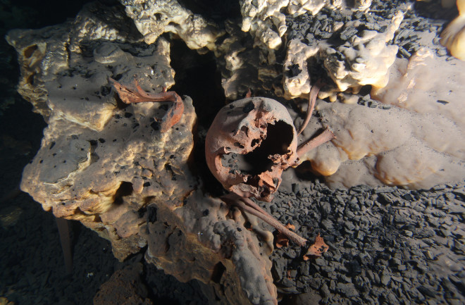
The remains, discovered in the caverns of the Mexican state of Quintana Roo, represent just four of the earliest North Americans, all of whom lived between 9,000 and 13,000 years ago. They’re important because North American remains from the first millennia of human habitation in the Americas are rare, said study leader Mark Hubbe, an anthropologist at The Ohio State University. Fewer than two dozen individuals have been discovered, he added.

What makes the four individuals from Mexico interesting is that none of them is quite alike. One resembles peoples from the Arctic, another has European features and one looks much like early South American skulls, while the last doesn’t share features with anyone population.

“The differences we see among these Mexican skulls are on the same magnitude as the most different populations nowadays,” Hubbe told Live Science.

The settlement of the Americas is a complicated topic, shrouded in mystery because of the dearth of archaeological findings from 15,000 to 20,000 years ago, which is probably when the first humans set foot on the continent. South America has more early human remains than North America, Hubbe said. The skulls found in South America are typically quite similar to one another, sharing features of skull measurements with indigenous Australians and Africans.

This doesn’t mean that the South Americans had ancestors who came directly from Australia or Africa, Hubbe cautions. Rather, the shared features reveal a shared common ancestry between ancient South Americans and the peoples of Australia and Africa. 

“The [skull] morphologies in Asia changed a lot in the last 10,000 years,” Hubbe said. “Everyone who came [to the Americas] before 10,000 years ago would look a lot like early modern humans out of Africa and Australia.”

Because the path to South America must have included pit stops in North America or along the Pacific coast, the assumption has long been that early people in South America looked a lot like early people in North America. But the new research suggests otherwise, Hubbe said. Instead, early North American populations look far more diverse than early South American populations.

“For whatever reason, when they went to South America, part of this diversity disappeared,” Hubbe said.

The extensive caves of Quintana Roo are now mostly underwater. But about 12,000 years ago, during the end of the Pleistocene epoch and the beginning of the Holocene, sea levels were lower and the caves were dry. Some of the early inhabitants of Mexico seemed to use the caves as burial places, deliberately placing bodies inside. Some other skeletons discovered in the caves appear to indicate that those people’s deaths may have been accidental.

Of the four skulls studied in the new research, published today in the journal PLOS ONE, one came from a young adult woman who lived around 13,000 years ago; one belonged to a young adult male from the same era; one was from a middle-aged woman who lived between about 9,000 and 12,000 years ago, and the fourth was that of a middle-aged man from around 10,000 years ago. Hubbe and his co-authors used computed tomography (CT) scanning to re-create digital, 3D images of the skulls. They then marked various landmarks on the skulls, such as the bottom of the nose or top of the eye orbits. Sizes and distances between landmarks were then used to compare the skulls to larger data sets of measurements from different populations of people around the world.

The four skulls, from cenotes (sinkholes) in the Mexican state of Quintana Roo, analyzed in the study.

There are limitations to working with the data of only four people, Hubbe said – after all, any given individual can be an outlier compared with the rest of his or her community. But, in an attempt to downplay any individual quirks of the skulls, the researchers focused only on the components of the measurements that explained the majority of the variations between skulls. By limiting the analysis to only major variations, they could avoid putting too much weight on smaller differences between skulls.

They found that the 13,000-year-old young woman had features that most closely matched Arctic North Americans from Greenland and Alaska. The young man from 13,000 years ago, on the other hand, looked most similar to people from European populations. The middle-aged female from between 9,000 and 12,000 years ago looked much like the earliest settlers of South America. Finally, the middle-aged man from around 10,000 years ago showed no clear pattern. He had features seen in several American and Asian populations.

The findings are important because they provide new information on the earliest Americans, said Richard Jantz, an anthropologist at the University of Tennessee who was not involved in the research. The skulls are diverse, he said, though he noted that all but the young man from 13,000 years ago had Asian or Native American affinities, so the differences shouldn’t be overexaggerated.

The new information complicates the fuzzy picture of who the first Americans were and how the earliest migrations worked.

North America could have been more diverse than South America if there were a consistent flow of people – and new genes – into North America, but only one or two big movements of populations through the funnel of Mexico into South America, Hubbe said.

“We cannot test this at this point,” he said.

That story also contradicts the genomic data researchers have collected. Genomics suggests that all Native Americans (with the exception of a few later migrants) descend from a single migration of people from Asia. But research-based on phenotype – the way people looked – suggests multiple migration events, creating a population that got regular injections of diversity. 

“I think if America consisted of a homogenous population 10,000 or 15,000 years ago, that drawing skulls at random from it would not produce as much variation as you see,” Jantz said. 

In today’s humans, Jantz said, genomics data and skull shape data generally mesh well — people with similar ancestry tend to show similarities in their skull measurements. So far, the same does not seem to be the case for the earliest Americans. But there are limitations in data on both the genetic and the archaeological sites, Jantz said. Genomics researchers have only three ancient DNA samples from North America, and modern Native Americans’ genetic profiles have been complicated by genocide and mixture with Europeans. Researchers who study skull morphology have only a handful of bones to work with, as well. 

“To me,” Jantz said, “the biggest challenge is reconciling conflicting lines of evidence.”

Maya Farmers May Have Planned for Population Growth

Maya Farmers May Have Planned for Population Growth

For years, experts in climate science and ecology have held up the agricultural practices of the ancient Maya as prime examples of what not to do. 

Maya Farmers May Have Planned for Population Growth
The research team surveyed a small area in the Western Maya Lowlands situated at today’s border between Mexico and Guatemala, shown in context here.

“There’s a narrative that depicts the Maya as people who engaged in unchecked agricultural development,” said Andrew Scherer, an associate professor of anthropology at Brown University. “The narrative goes: The population grew too large, the agriculture scaled up, and then everything fell apart.”

But a new study, authored by Scherer, students at Brown and scholars at other institutions, suggests that that narrative doesn’t tell the full story. Using drones and lidar, a remote sensing technology, a team led by Scherer and Charles Golden of Brandeis University surveyed a small area in the Western Maya Lowlands situated at today’s border between Mexico and Guatemala.

Scherer’s lidar survey — and, later, boots-on-the-ground surveying — revealed extensive systems of sophisticated irrigation and terracing in and outside the region’s towns, but no huge population booms to match.

The findings demonstrate that between 350 and 900 A.D., some Maya kingdoms were living comfortably, with sustainable agricultural systems and no demonstrated food insecurity. “It’s exciting to talk about the really large populations that the Maya maintained in some places; to survive for so long with such density was a testament to their technological accomplishments,” Scherer said.

“But it’s important to understand that that narrative doesn’t translate across the whole of the Maya region. People weren’t always living cheek to jowl. Some areas that had the potential for agricultural development were never even occupied.”

The research group’s findings were published in the journal Remote Sensing. When Scherer’s team embarked on the lidar survey, they weren’t necessarily attempting to debunk long-held assumptions about Maya agricultural practices. Rather, their primary motivation was to learn more about the infrastructure of a relatively understudied region.

While some parts of the western Maya area are well studied, such as the well-known site of Palenque, others are less understood, owing to the dense tropical canopy that has long hidden ancient communities from view.  It wasn’t until 2019, in fact, that Scherer and colleagues uncovered the kingdom of Sak T’zi’, which archaeologists had been trying to find for decades.

Lidar scans of the research area revealed the relative density of structures in Piedras Negras, La Mar and Lacanjá Tzeltal, providing hints at these cities’ respective populations and food needs.

The team chose to survey a rectangle of land connecting three Maya kingdoms: Piedras Negras, La Mar and Sak Tz’i’, whose political capital was centred on the archaeological site of  Lacanjá Tzeltal.  Despite being roughly 15 miles away from one another as the crow flies, these three urban centres had very different population sizes and governing power, Scherer said.

“Today, the world has hundreds of different nation-states, but they’re not really each other’s equals in terms of the leverage they have in the geopolitical landscape,” Scherer said. “This is what we see in the Maya empire as well.”

Scherer explained that all three kingdoms were governed by an ajaw, or a lord — positioning them as equals, in theory. But Piedras Negras, the largest kingdom, was led by a k’uhul ajaw, a “holy lord,” a special honorific not claimed by the lords of La Mar and Sak Tz’i’. La Mar and Sak Tz’i’ weren’t exactly equal peers, either: While La Mar was much more populous than the Sak T’zi’ capital Lacanjá Tzeltal, the latter was more independent, often switching alliances and never appearing to be subordinate to other kingdoms, suggesting it had greater political autonomy.

The lidar survey showed that, despite their differences, these three kingdoms boasted one major similarity: agriculture that yielded a food surplus.

“What we found in the lidar survey points to strategic thinking on the Maya’s part in this area,” Scherer said.

“We saw evidence of long-term agricultural infrastructure in an area with relatively low population density — suggesting that they didn’t create some crop fields late in the game as a last-ditch attempt to increase yields, but rather that they thought a few steps ahead.”

The lidar — along with boots-on-the-ground surveying (left) and aerial photography (right) — showed evidence of expansive irrigation channels across the region. The depression with dark soil at the left shows the remains of an ancient channel.

In all three kingdoms, the lidar revealed signs of what the researchers call “agricultural intensification” — the modification of land to increase the volume and predictability of crop yields. Agricultural intensification methods in these Maya kingdoms, where the primary crop was maize, included building terraces and creating water management systems with dams and channelled fields. Penetrating through the often-dense jungle, the lidar showed evidence of extensive terracing and expansive irrigation channels across the region, suggesting that these kingdoms were not only prepared for population growth but also likely saw food surpluses every year.

“It suggests that by the Late Classic Period, around 600 to 800 A.D., the area’s farmers were producing more food than they were consuming,” Scherer said. “It’s likely that much of the surplus food was sold at urban marketplaces, both as producer and as part of prepared foods like tamales and gruel, and used to pay tribute, a tax of sorts, to local lords.”

Scherer said he hopes the study provides scholars with a more nuanced view of the ancient Maya — and perhaps even offers inspiration for members of the modern-day agricultural sector who are looking for sustainable ways to grow food for an ever-growing global population. Today, he said, significant parts of the region are being cleared for cattle ranching and palm oil plantations. But in areas where people still raise corn and other crops, they report that they have three harvests a year — and it’s likely that those high yields may be due in part to the channelling and other modifications that the ancient Maya made to the landscape. 

“In conversations about contemporary climate or ecological crises, the Maya are often brought up as a cautionary tale: ‘They screwed up; we don’t want to repeat their mistakes,’” Scherer said. “But maybe the Maya were more forward-thinking than we give them credit for. Our survey shows there’s a good argument to be made that their agricultural practices were very much sustainable.”

Aside from Scherer and Golden, study authors include Brown PhD students Mark Agostini, Morgan Clark, Joshua Schnell and Bethany Whitlock; recent Brown PhD graduates Mallory Matsumoto, now an assistant professor at the University of Texas at Austin, and Alejandra Roche Recinos, now a visiting assistant professor at Reed College; and researchers from McMaster University and the University of Florida. The research was funded in part by the Alphawood Foundation, the National Science Foundation and the Social Sciences and Humanities Research Council of Canada.

Chaco Canyon Polydactyly: A Thousand-Year-Old Foot Fetish?

Chaco Canyon Polydactyly: A Thousand-Year-Old Foot Fetish?

If you’re a 12-toed guy struggling to make it in this ten-toed world, you may want to find a time machine and travel back about a thousand years to the Chaco Canyon in New Mexico.

According to new research, a group of people once lived there who respected, honoured and exalted those among them with an extra piggy on a foot.

We found that people with six toes, especially, were common and seemed to be associated with important ritual structures and high-status objects like turquoise.

Anthropologist Patricia Crown of the University of New Mexico co-authored a study, published this week in American Antiquity, about a high preponderance of six-toed people – the condition is known as polydactyly – among a prehistoric Pueblo culture in the Chaco Canyon.

Of the 96 skeletons of Chacoan people found at the canyon’s sacred Pueblo Bonito site, 3 of them had an extra toe on the right side of their right foot. That’s 15.5 times the average occurrence of polydactyly among modern Native Americans.

Chaco Canyon Polydactyly: A Thousand-Year-Old Foot Fetish?
Six-toed imprint on a Pueblo wall

What gave the Chacoans another toenail to trim with a flint? Previous research on polydactyly shows it’s a dominant, non-recessive, hereditary trait that is not caused by inbreeding nor a genetic disease.

Study co-author Kerriann Marden suspects prenatal exposure to something hazardous, either environmental or possibly a food the pregnant mother ate. With the way the extra-toed were treated, perhaps the mothers may have even tried to have polydactyly babies.

The Mayans were known to worship six-toed people (and others with body anomalies) as gods, but the Chacoans weren’t that extreme. Handprints and footprints with extra digits appear on walls in rooms used for rituals and ceremonies.

One skeleton was buried with jewellery on the six-toed foot but nothing on the other one. Special extra-wide sandals were found with space for the extra toe.

Another six-toed wall imprint

The sandals and artwork may be the key to why the extra toes got respect.

The Chacoans art seemed to be focused on hands and feet and they appear to have paid special attention to sandals and footwear in general. Perhaps that fixation made those with two pinkie toes special.

Perhaps it was just because they could step on more ants.

Rare 1,000-year-old canoe found in a cenote near Chichén Itzá

Rare 1,000-year-old canoe found in cenote near Chichén Itzá

A remarkably well-preserved Maya canoe — built for use some 1,100 years ago — has been found in a freshwater pool, or ‘cenote’, in Yucatán, southern Mexico. The wooden artefact — more than five feet in length — was found near the ruined city of Chichen Itza by Instituto Nacional de Antropologia e Historia experts.

The archaeologists believe that the canoe was likely used either to aid in extracting water from the cenote or to help deposit offerings there during rituals. 

Alongside the canoe, the pool and adjacent water bodies yielded other finds — including a human and ceramic skeleton, and a hand mural on a rock ceiling. This mural appears to be significantly older than the canoe, dating back to the Maya Late Postclassic Period, which ran from 1200–1500 CE.

Rare 1,000-year-old canoe found in cenote near Chichén Itzá
A remarkably well-preserved Maya canoe (pictured) — built for use some 1,000 years ago — has been found in a freshwater pool, or ‘cenote’, in the Yucatán, southern Mexico
Additionally, the researchers explained, the discoveries of a sculpted stone stela, ritual knife and 40 broken vessels (like that pictured) indicate that the cenote was long a site for rituals

Additionally, the researchers explained, the discoveries of a sculpted stone stela, ritual knife and 40 broken vessels indicate that the cenote was long a site for rituals.

‘It is evident that this is an area where ceremonies were held,’ said the Instituto Nacional de Antropologia e Historia archaeologist Helena Barba Meinecke.

This is discernible, she explained, ‘not only because of the intentionally fragmented pottery but also because of the remains of charcoal that indicate their exposure to fire and the way they placed stones on top of them to cover them.’

Furthermore, Ms Barba Meinecke noted, the fact that the pottery remains come in various different styles dating from different time periods indicates that the site was used for rituals over the course of many centuries.

‘The relevance lies in the fact that it is the first canoe of this type that is complete and so well preserved in the Mayan area,’ she continued.

‘There are also fragments of these boats and oars in Quintana Roo, Guatemala and Belize.’

The canoe dates back to the end of the classic period of Maya history which spanned from 830–950 CE when the civilisation was still at its peak.

The discoveries were made as part of Tren Maya — or ‘Maya Train’ — an initiative from Mexico’s President Andrés Manuel López Obrador to lay a high-speed intercity train line across the heart of the Yucatán peninsula.

The multi-billion-dollar construction effort has attracted a great deal of controversy, not only for its environmental impacts but also for how the line cuts through regions rich in indigenous Maya culture and archaeological sites.

Nevertheless, the program has offered Instituto Nacional de Antropologia e Historia researchers an opportunity to preserve some of the history being uncovered along the Tren Maya route — with hundreds of burials and ceramic vessels already found.

‘The construction of the Mayan Train constitutes an important research opportunity, through archaeological recovery,’ the experts said in a statement.

Such excavations, they said, will allow them to expand our ‘knowledge about the archaeological sites of the regions that the train will travel through.’

‘It is evident that this is an area where ceremonies were held,’ said the Instituto Nacional de Antropologia e Historia archaeologist Helena Barba Meinecke. Pictured: the researchers take measurements within the cenote site
The ritual nature of the cenote site is discernible, Ms Barba Meinecke explained, ‘not only because of the intentionally fragmented pottery but also because of the remains of charcoal that indicate their exposure to fire and the way they placed stones on top of them’
‘The relevance lies in the fact that it is the first canoe of this type that is complete and so well preserved in the Mayan area,’ Ms Barba Meinecke continued. ‘There are also fragments of these boats and oars in Quintana Roo, Guatemala and Belize.’ Pictured: an artefact at the site

With their initial study complete, the team will now be collaborating with experts from the Sorbonne University in Paris, France, to more precisely date and analyse the wood making up the canoe. 

READ ALSO: CAVE FULL OF UNTOUCHED MAYA ARTIFACTS FOUND AT CHICHÉN ITZÁ

Alongside this, the researchers have plans to produce a three-dimensional digital model of the vessel based on photographs — one which can be independently analysed and from which replicas might be made for display in museums.

Back at the cenote, the archaeologists are also hoping to drill a borehole in the sediments underneath the site, from which they will be able to determine the nature of the environment at the time the canoe was in use.

Marks of the stone wall of the cenote, the team explained, has indicated that the water level at the site used to be some 16 feet lower than it is today. It was at this depth that the cave containing the canoe was found.

Archaeologists Map Nearly 500 Mesoamerican Sites and See Distinct Design Patterns

Archaeologists Map Nearly 500 Mesoamerican Sites and See Distinct Design Patterns

Gizmodo reports that lidar technology was used to create 3-D maps of some 30,000 square miles of Mexico, revealing more than 475 archaeological sites dating from 1400 B.C. to A.D. 1000.

A lidar image of the sites of San Lorenzo (left) and Aguada Fénix (right) show striking similarities, with a long rectangular platform and 20 edge platforms.

The 478 sites included in the new research were inhabited from around 1400 BCE to 1000 CE, and the way they were constructed appears to be linked to cosmologies important to the communities that lived there.

Settlements that align with nearby mountain peaks or the Sun’s arc across the sky suggest there may have been symbolic importance to the orientation of the architecture.

The team categorized the sites into five distinct types of architectural arrangements, which they think might correspond to different time periods and indicate more egalitarian societies.

All the sites had rectangular or square features, which the archaeologists say may have been inspired by the famous Olmec site of San Lorenzo, which had a central rectangular space that was likely used as a public plaza. The team’s survey and analysis were published today in Nature Human Behavior.

“The main point of this study is the discovery of nearly 500 standardized complexes across a broad area, many of them having rectangular shapes,” wrote lead author Takeshi Inomata, an archaeologist at the University of Arizona, in an email to Gizmodo. “Until three years ago, we had no idea about the presence of such complexes. They really force us to rethink what was happening during this period.

The team used an aerial scanning technology called lidar to map hidden structures at these sites. With lidar, archaeologists can get precision measurements of ground elevation change, even through dense tree coverage, thanks to lasers that penetrate the surface and then bounce back to a detector.

Lidar is “revolutionary for archaeology,” Robert Rosensweig, an archaeologist at the University of Albany-SUNY who didn’t work on the recent paper, wrote in an accompanying News & Views article for Nature

“The study foreshadows the future for archaeology as lidar reveals ancient architecture at an unprecedented scale that will reach into remote and heavily vegetated regions the world over,” Rosensweig added.

In 2020, Inomata and his colleagues reported their discovery of the monumental site of Aguada Fénix using lidar imaging. Now, they’ve looked at 2,000 years of architecture in the region through aerial lidar surveys.

A lidar-based illustration of the site Buenavista, which appears to be aligned with the sunrise on certain days of the year.

The people who designed these settlements are broadly called the Olmec and Maya, though there are better, more specific names for communities that fall under those labels, such as the Chontal-speaking residents of eastern Tabasco and the Zoke-speaking people of western Tabasco and Veracruz.

The Olmec site maps are particularly handy; the centre of San Lorenzo is the oldest capital in the area (it’s the home of those colossal heads you might be familiar with), and as such, archaeologists believe it may have set the standard for how to layout a settlement.

But San Lorenzo was well known already; part of the value of this new research is highlighting the structures of smaller settlements. “Although this part of Mexico is fairly open and populated, most of those sites were not known before,” Inomata added. “They were literally hiding in plain sight.”

Together, the nearly 500 sites give archaeologists a sense of how communities in the area are organized. Inomata said the research impacts are two-fold: One, archaeologists now have a better idea as to the development of monumental building projects in the region over time. Two, based on the site layouts, it appears that communities didn’t have a highly stratified social hierarchy.

READ ALSO: LIDAR REVEALS NETWORK OF ANCIENT VILLAGES IN BRAZIL’S RAINFOREST

“Traditionally, archaeologists thought large constructions were done by hierarchical societies with elites and rulers,” Inomata said. “But we now see that those large and standardized spaces could be built by people without pronounced inequality.” That determination is in part based on the lack of large permanent residences at many of the sites.

The archaeological team’s next steps are to visit the sites in person, to verify that the patterns represented from the air are the reality on the ground. That’s an extremely important step, as evidenced by a situation in 2016 in which a teenager thought he found a lost city in satellite imagery, only for archaeologists to disagree, saying it was probably a fallow maize field.

So far, only about 20% of the sites the team surveyed have been studied on the ground. While those ground survey results are promising, more data needs to be collected for researchers to know the extent of architectural similarities and differences in the region.

El Pital: A Massive Ancient Port City Home to 150 Pyramids

El Pital: A Massive Ancient Port City Home to 150 Pyramids

The remains of a huge, ancient port city believed to have flourished for 500 years during the decline of the Roman Empire have been discovered on Mexico’s Gulf Coast, the National Geographic Society announced Thursday.

With more than 150 earthen pyramids and other buildings, the biggest 100 feet high, the port seems to have been North America’s largest coastal city 1,500 years ago. The site, in the state of Veracruz, has been named El Pital for a nearby town.

Although digging has not begun at the site, an examination of the surface has already yielded artefacts and information that establish the city’s importance as a multiethnic political, commercial and agricultural centre from AD 100 to 600.

150 pyramids

El Pital could provide important clues to gaps in ancient Mexican history in areas bordering the seats of the Mayan and Aztec empires, said American archaeologist S. Jeffrey K. Wilkerson of the Institute for Cultural Ecology of the Tropics in Tampa, Fla. He is directing the exploration, which is partly funded by National Geographic.

El Pital residents probably traded with their contemporaries at Teotihuacan, the site of the famous pyramids north of the capital that was built by a civilization that predated the Aztecs.

The city is likely to have been an early rival of El Tajin, a later city 40 miles away that until now was the biggest archaeological site in northern Veracruz. El Pital appears to have been larger than El Tajin, controlling an area that included more than 40 square miles of suburbs and farmland and probably influencing an area several times that large.

The discovery could also have significant ecological implications because the ancient civilization seems to have supported more than 20,000 people–similar to the population of the area today–using farming techniques less harmful to the environment than the intensive chemical agriculture now practised there.

“The (population) density we’re seeing far exceeds anything that preceded it in this area and even those that follow until the end of the 20th Century,” Wilkerson said. “Something special was going on technologically that allowed that to happen and that has not occurred in the intervening 1,500 years.”

The fields around El Pital were made highly productive by some of the largest earth-moving projects of their time. Canals were dug to drain wetlands or to channel fresh water into rich estuaries that brackish water would otherwise have left infertile.

Residents also appear to have constructed an artificial island to guard the two slow-moving rivers that provided access to their city from the Gulf of Mexico. One of those rivers is the Nautla, Mexico’s 26th-largest river, notable because it floods every year, like the ancient Nile, leaving farmers a layer of rich silt.

The city’s demise may have been connected to a megacycle of El Nino, a climatic phenomenon that resulted in six months a year of the cold, windy rains known as nortes , Wilkerson theorized.

Some cocoa farmers still lived in the region at the time of the Spanish conquest, but the disease had mainly wiped them out by the end of the 16th Century. The jungle reclaimed the area until plantation owners cleared it again in the 1930s and 1940s.

Today’s farmers rely on chemicals to fertilize plantations in what is now one of Mexico’s most important banana and citrus regions. Those chemicals have stained ancient ceramic fragments–whose varied patterns led scientists to believe that the area was multiethnic–and even obsidian, an extremely dense volcanic material seldom penetrated, Wilkerson said.

Besides everyday ceramics, archaeologists have found a mask that resembles the image of the ancient rain god Tlaloc and a four-inch clay head believed to depict a sacrificed ballgame player. Residents of El Pital seem to have been major fans of ballgames: Eight courts have already been identified in the area.

“This is an extensive site with huge monuments for that period,” said Enrique Nalda, technical secretary of Mexico’s National Institute of Archeology and History, which granted Wilkerson a permit to explore the El Pital area.

Some of the pyramids at El Pital.

Ironically, Wilkerson discovered El Pital because the institute nearly two years ago refused to allow him to continue working in an area farther upriver, where he has carried out investigations over the last three decades.

1,800-Year-Old Offering to the Gods Discovered Beneath Pyramid of Teotihuacan

1,800-Year-Old Offering to the Gods Discovered Beneath Pyramid of Teotihuacan

Several bouquets of offering flowers have been discovered 59 feet below the temple of the god Quetzalcóatl – a pyramid that still stands in the Mexican ruined city of Teotihuacan. 

Quetzalcóatl, or ‘Plumed Serpent’ was an important god during ancient Mesoamerica, a historical region that included central Mexico through Belize, Guatemala, El Salvador, Honduras, Nicaragua and northern Costa Rica.

This deity was said to have given maize to humanity and was responsible for the creation of mankind, which may be why offering flowers were uncovered under the god’s temple.

Sergio Gómez, an archaeologist at Mexico’s National Institute of Anthropology and History, said the stems are in good condition and still tied with the original cotton-made cords.

‘In total there are four bouquets of flowers in very good condition, they are still tied with ropes, probably cotton,’ Gómez told Mexican news outlet La Jornada.

‘This is a very important find because it speaks of the rituals that were carried out in this place.’

Gómez says it is too early to determine what kind they are – but he hopes to solve that mystery soon.

‘Although we do not know the exact date of when they were deposited, because we just took them out this week, they must be very old and correspond to the first phases of Teotihuacan, between 1,800 and 2,000 years ago,’ Gómez explained.

1,800-Year-Old Offering to the Gods Discovered Beneath Pyramid of Teotihuacan
The stems are in good condition and still tied with the original cotton-made cords
1,800-Year-Old Offering to the Gods Discovered Beneath Pyramid of Teotihuacan
Teotihuacan, with its huge pyramids of the sun and moon, is made up of a labyrinth of palaces, temples, homes, workshops, markets and avenues. The city is thought to have been built in 100BC and existed until the 8th century

‘We have found complete objects that were placed in this shot; the ceramics are also from the Zacuali and Miccaotli phases, from the beginning of our era, between years zero and 200 after Christ.’

Gómez has been working in the ruined city for nearly 12 years, sifting through ancient soil, rocks and pyramids looking for clues about those who once called the area home.

Some 30 miles (50km) north of Mexico City, Teotihuacan, with its huge pyramids of the sun and moon, is made up of a labyrinth of palaces, temples, homes, workshops, markets and avenues.

The city is thought to have been built in 100BC and existed until the 8th century. Archaeologists consider it one of the most influential in pre-Hispanic North America, with a population of 200,000 at its peak.

However, only 5 per cent of Teotihuacan has been excavated despite more than 100 years of exploration. During excavations, Gómez as recovered more than 100,000 artifacts within the ancient city and specifically under the three pyramids that are still standing.

However, the offering flowers are the first intact botanical materials every to be found at the site.

‘It is very relevant because it will give us indications of the flora that was used for ritual purposes,’ Gómez said.

In 2011, archaeologist uncovered other offerings at the base of the pyramid, including animal remains, three human figurines and a haunting, green mask that was used in rituals 2,000 years ago
The mask was carved from a single jade stone and is the only one of its kind to be discovered in thee ancient city

‘In this same context, while sifting the earth, several kilos of charcoal were found as a result of a ritual ceremony that included the burning of seeds and fruits.’

In 2011, archaeologists uncovered other offerings at the base of the pyramid, including animal remains three human figurines and a haunting, green mask that was used in rituals 2,000 years ago.

Perez Cortez, an investigator with the Zacatecas INAH Center, said in a statement when the mask was discovered: ‘We know [the offerings were] deposited as part of a dedication ceremony.’

The mask was carved from a single jade stone and is the only one of its kind to be discovered in the ancient city. 

Fossil footprints show humans in North America more than 21,000 years ago

Fossil footprints show humans in North America more than 21,000 years ago

The question of when humans first migrated to North America has long been a matter of hot debate among researchers who have continually uncovered evidence of ever-earlier dates. Now, analysis of ancient fossilized human footprints in New Mexico has pushed the date back once again — to at least 21,000 years ago.

Fossilized human footprints showed at the White Sands National Park in New Mexico. According to a report published in the journal Science, the impressions indicate that early humans were walking across North America around 23,000 years ago.

Writing in the journal Science, a team of researchers led by Matthew Bennett of Bournemouth University in England examined a set of human footprints preserved on an ancient lakeshore in New Mexico’s White Sands National Park, a location now known for its expansive — and dry — chalk-coloured dunes.

They concluded that the footprints were made between 21,000 and 23,000 years old. The date would place human habitation in the Americas during the Last Glacial Maximum and at least 5,000 years earlier than widely accepted evidence has yet suggested.

The team has studied the footprints at White Sands National Park for years, excavating trenches and following the tracks with ground-penetrating radar.

The footprints were mostly made by children and teenagers

Bennett and his colleagues, whose paper was published Thursday, determined that the tracks belonged to numerous people, mostly children and teenagers. What’s more, the footprints spanned a significant time period, suggesting that humans frequented the area for at least a few thousand years.

“One of the beautiful things about footprints is that, unlike stone tools or bones, they can’t be moved up or down the stratigraphy,” Bennett says, according to Science News, referring to the layers where artefacts and fossils are found. “They’re fixed, and they’re very precise.”

Normally, rock layers are “a nightmare” to date, says Bennett, a professor of environmental and geographical sciences. But he says that two years ago, archaeologist David Bustos, a study co-author, discovered a site where human footprints were co-mingled with a layer of sediment containing seeds from the spiral ditch grass, an aquatic plant that could be carbon-dated. The results gave an estimate for the footprints.

Tom Higham, an archaeological scientist and radiocarbon-dating expert at the University of Vienna, who was not part of the study, called the latest findings “extremely exciting.”

“I am convinced that these footprints genuinely are of the age claimed,” he said, according to Nature.

The evidence for older dates for migration to the Americas is less solid

Although previous studies have suggested an even earlier migration of modern humans into North America — including a controversial 2017 paper suggesting that people lived in the Southern California region as long as 130,000 years ago — those claims have been largely discounted because of the “equivocality of the evidence,” Nature says. For instance, rocks were mistaken for tools, and marks on animal bones thought to be made by humans turned out to have a natural origin, the journal says.

“For decades, archaeologists have debated when people first arrived in the Americas,” says Vance Holliday, a University of Arizona archaeologist and co-author of the latest paper.

“Few archaeologists see reliable evidence for sites older than about 16,000 years. Some think the arrival was later, no more than 13,000 years ago by makers of artefacts called Clovis points.”

Last year, Nature published a paper by archaeologists who claimed to have found human artefacts in Mexico’s Chiquihuite Cave dating to at least 26,000 years ago.

But many fellow archaeologists were sceptical, pointing to the possibility that what the researchers had identified as stone tools were in fact naturally fractured rocks.

Ciprian Ardelean, who led the 2020 study at Chiquihuite, readily acknowledges that the discovery by Bennett and his colleagues “is very close to finding the Holy Grail.”

“I feel a healthy but profound envy — a good kind of jealousy — towards the team for finding such a thing,” Ardelean told National Geographic.