5,500-Year-Old Circular Pyramid Discovered In Peru
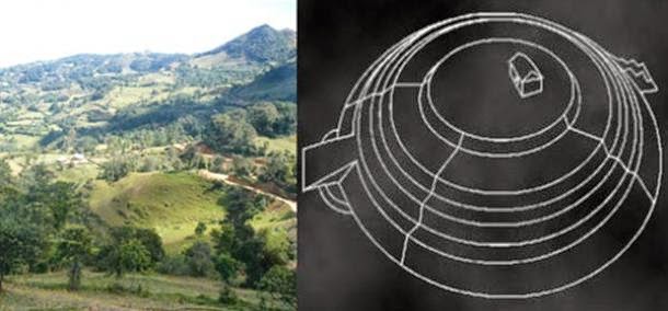
Archaeologists in Peru have discovered an ancient ceremonial centre and a circular-shaped pyramid in Miravalles, in the region of Cajamarca in northern Peru.
According to a news report in The Epoch Times, the site dates back an incredible 5,500 years. Until now, it was believed that the Norte Chico civilization of Supe, Peru was the earliest civilization in the Americas.
Their capital was the Sacred City of Caral – a 5,000-year-old metropolis complete with complex agricultural practices, rich culture, and monumental architecture, including six large pyramidal structures, stone and earthen platform mounds, temples, amphitheatre, sunken circular plazas, and residential areas.
However, the latest discovery suggests that the Norte Chico civilization may not be the oldest after all.
The discovery was announced by researcher Victor Colan at a Peruvian press conference on 21st October. Colan revealed that the research team found a ceremonial centre and a circular step-pyramid (known in Peru as Huacas), with three platforms 30 meters in diameter.
The ancient city of Caral
The pyramid resembles two other circular Huacas found in Jaen, also in the Cajamarca region.
The structure had large semi-circular walls built with a mixture of mud mortar and stones up to 200 kg in weight.
Foundations of a circular Huacas found in Jaen, Cajamarca
“The archaeological site of Miravalles in the province of San Miguel in Cajamarca with 5,500 years, is 500 years more ancient than the sacred city of Caral,” said Colan.
“Not only Caral is the original centre of the civilization of Peru but so is Cajamarca, in northern Peru.”
The researcher concluded that “Peru is the oldest civilization in the world along with Mesopotamia and Egypt,” and asked the Ministry of Culture to continue financing the excavations.
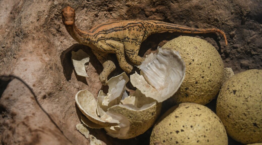
A 193-million-year-old nesting ground with more than 100 dinosaur eggs offers evidence they lived in herds
A 193-million-year-old nesting ground containing more than 100 dinosaurs’ eggs is upending palaeontologists’ understanding of an early dinosaur species.
An artist’s reconstruction of a Mussaurus patagonicus nest.
Research published Thursday describes a collection of eggs and juvenile and adult skeletons from a dinosaur called Mussaurus patagonicus, which were found in Patagonia, Argentina. The dino is an ancestor of long-necked herbivores called sauropods, such as Brachiosaurus.
Most of the chicken-sized eggs were discovered in clusters of eight to 30, suggesting they resided in nests as part of a common breeding ground. Scientists also found Mussaurus skeletons of similar sizes and ages buried together. Combined, these patterns offer evidence that the dinosaurs lived in herds.
“I went to this site aiming to find at least one nice dinosaur skeleton. We ended up with 80 skeletons and more than 100 eggs (some with embryos preserved inside!)” Diego Pol, a researcher with the Egidio Feruglio palaeontology museum in Patagonia and the lead author of the new study, told Insider via email.
He called the site “one of a kind.”
Before this discovery, researchers thought herding behaviour was restricted to dinosaurs that came much later, in the very late Jurassic and early Cretaceous periods. That’s because the earliest fossil evidence of sauropod herds only dates back 150 million years. This nesting ground, however, pushes that timeline back more than 40 million years. It’s the earliest known evidence of social groups among dinosaurs, the study authors said.
X-rays offer a peek into fossilized dinosaur eggs
A fossilized Mussaurus egg that’s more than 190 million years old, found in southern Patagonia, Argentina.
Argentine palaeontologists discovered the first Mussaurus skeletons at this Patagonian site in the late 1970s. The dinosaurs they found were no more than 6 inches long. Unaware that they’d uncovered newborns, the researchers named the creature “mouse lizard” because of the skeletons’ tiny size.
Pol decided to reexplore the area starting in 2002, and by 2013, he’d helped find the first adult Mussaurus fossils there. Those bones revealed that full-grown versions of these “mouse lizards” were closer in size to modern-day hippos. They grew to weigh about 1.5 tons, reaching lengths of 26 feet from nose to tail tip. But infants could fit in the palm of a human hand.
A screen shot from a video showing how scientists like Diego Pol used high-energy X-rays to peek inside a Mussaurus egg without destroying it.
Since then, Pol’s team has also uncovered and studied the contents of the nesting ground, which measures just under half a square mile. In 2017, he took 30 of the eggs to a lab in France, and his group then used X-ray technology to peek inside and confirm the species of the embryos without breaking the shells.
By analyzing the sizes and types of bones in the nesting ground, the researchers determined that the animals were buried near counterparts of a similar age. Some clusters had juveniles less than a year old, others consisted of individuals that were slightly older but not yet fully grown, and finally, there were smatterings of adults that had died solo or in pairs.
That type of age segregation, the researchers said, is a key sign of herds: Juveniles hung out with others their age while adults looked for food and protected the community.
“They were resting together and likely died during a drought,” Pol said. “This is compatible with a herd that stays together for many years and within which the animals get close to each other to rest, or to forage, or do other daily activities.”
Another strong indication of herd behaviour is the nesting ground itself: If Mussaurus lived as a community, it would make sense that they’d lay eggs in a common area.
Living in herds may have helped Mussaurus survive
Nest with Mussaurus eggs dated to more than 190 million years ago, found in Patagonia. Diego Pol
To figure out the fossils’ ages, researchers examined minerals in volcanic ash that was scattered around the eggs and skeletons and determined that the fossils were about 193 million years old.
Previously, scientists thought this type of dinosaur lived during the late Triassic period, about 221 million to 205 million years ago. But the new date suggests instead that Mussaurus thrived during the early Jurassic period. That, in turn, is evidence that Mussaurus’ ancestors survived a mass extinction event 200 million years ago.
The key to that survival, the study suggests, may have been their herding behaviour.
“These were social animals and we think this may be an important factor to explain their success,” Pol said.
An artist’s depiction of the nesting ground of a Mussaurus herd of in what is now Argentina. Jorge Gonzalez
Communal living likely helped Mussaurus find enough food, perhaps by making it easier for them to forage over larger areas. Mussaurus of the same size would likely “group together to coordinate their activities,” Pol said, given that larger adults and tinier juveniles moved at different speeds.
He added that given the size difference between newborns and adults, it probably took these dinosaurs many years to reach full size. So young Mussaurus might have been vulnerable to predation.
By staying in herds, adults could better protect their young.
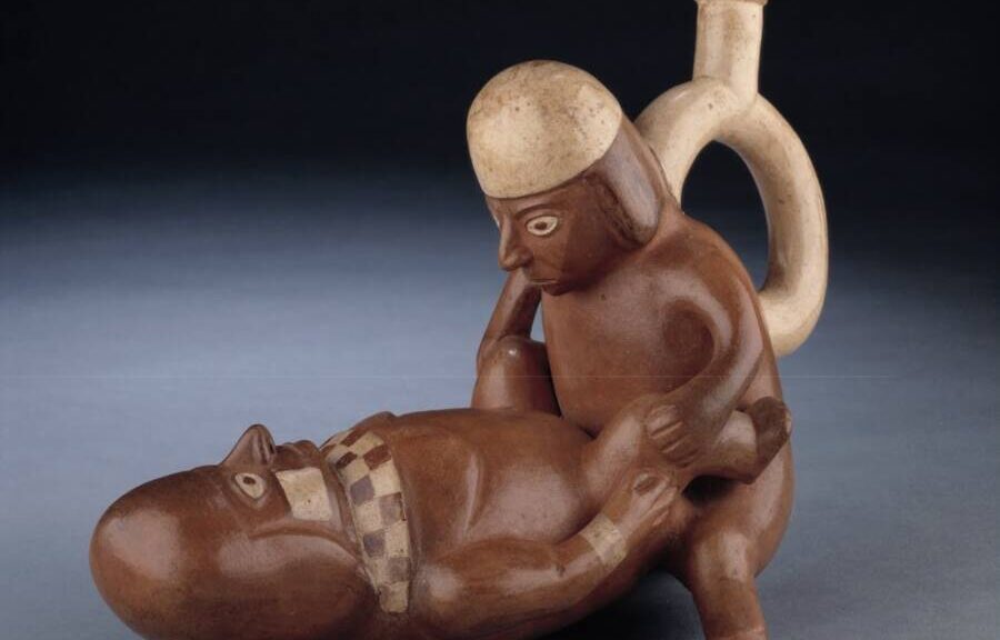
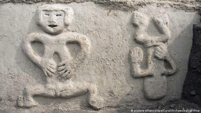
Ancient erotic pottery teaches Peruvians to prevent prostate cancer
The Larco Museum in Lima, Peru, showcases hundreds of “huacos,” a pre-Columbian term for handicrafts.
The Larco Museum in Peru boasts one of the finest collections of pre-Columbian Mochica sculptures in the world — and most of them are very sexually explicit. But rather than keep them encased in displays, the museum has recently begun to use the ancient artworks to promote self-screening for cancer.
According to Reuters, the exhibition, called “Touch the Genitals of the Mochica,” launched on Feb. 25, 2022, and allowed men to touch the sculptures, which are over 1,000 years old.
With hundreds of items on display, visitors perused a wide variety of sexualized sculptures. Depicting a range of erotic acts and sexual anatomy, these clay ceramics left some museumgoers visibly shy. Ultimately, the museum encouraged touching them to learn how to spot cancers.
“The aim is to bring closer the knowledge of our ancestors about the human body, expressed through these ceramic vessels that we call the ‘Erotic Huacos,’” said Larco Museum Director Ulla Holmquist.
The erotic huacos range from stand-alone figures with giant penises to multi-person sculptures engaged in a variety of sexual positions.
The exhibit came in the wake of devastating figures regarding access to healthcare during the global COVID-19 pandemic. When the annual average of 8,700 male cancer diagnoses in Peru surpassed 10,000 in 2021, health officials perked up.
The museum partnered with the League Against Cancer, a private company that reported that 45 per cent of those diagnosed cases were too advanced to be cured.
“Timely detection of cancer of the external genitalia in men, both the penis and testicles, is very low,” said Giselle Grillo from the League Against Cancer. “Many do not know how to explore their genitals, what palpation is. With this, we give an early diagnosis.”
The men were told to feel for bumps, smooth or rough spots, and other abnormalities in the ancient art in an effort to model how to undertake a proper self-examination.
The League Against Cancer explained that men should wear gloves before lubricating one finger and then inserting it into the rectum to check for soft or hard bumps around the prostate when performing a personal screening. While the organisation is using the artwork of the Moche culture to promote as much, they’ve also posted instructions online.
Most huacos from the Moche culture depict heterosexual anal sex, with vaginal penetration rather infrequent.
The Moche culture thrived in northern Peru from about 150 C.E. through the end of the eighth century and established its capital near present-day Moche in Trujillo. With agriculture as its foundation, the civilization constructed an impressive irrigation network to nurture its crops.
Perhaps most fascinating was their art, which was primarily erotic.
The Moche culture depicted all sorts of activities in their colourful murals and handcrafted ceramics. From fishing and hunting to war and human sacrifice, their iconographies reflected their interests. However, their “huacos,” a pre-Columbian term for handcrafted ceramics, were focused on sex.
As published in the American Anthropologist journal, a 2004 study noted at least 500 huacos were sexually themed. Curiously, most of these depicted heterosexual anal sex and rarely showed vaginal penetration. Scholars believe sex symbolized circulation and flow to the Moche and honored their successful irrigation techniques, the basis of their agricultural society. Historians also posited that the loss of fluids from the human body represented the disappearance of water from the land.
Visitors were encouraged to touch the sculptures and practice checking for lumps.
Mochica art has indeed shown dying warriors bleeding from the nose or people having their eyes torn out by predators — and would catch the attention of cancer-prevention officials 1300 years later.
José Medina, a urologist with League Against Cancer, also wanted to “call on the population to undergo annual medical examinations in order to have a timely diagnosis.”
He said that self-diagnosis is only a first step that will increase early detection, and he was hopeful that the new partnership would raise awareness through its novelty.
The Discovery Of A Maya Shrine Reveals Arrival Of “New World Order”
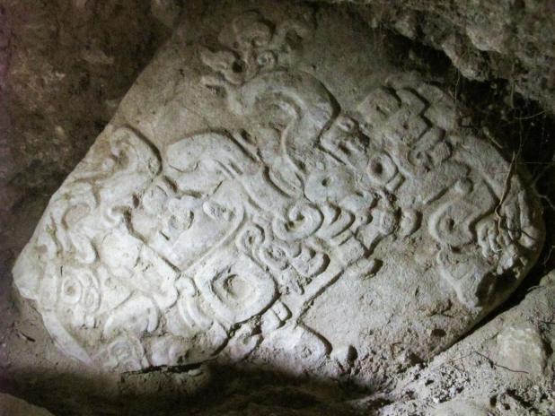
Researchers are surprised with a new discovery consisting of fragments of an ancient Maya shrine which reveals “previously unknown” details of a “Cold War” in the Maya Empire. The fragment of the carved stone monument was discovered at El Achiotal, an ancient Maya site located that depicts the face of an ajaw vassal lord.
This incredible new discovery at the Maya site in Guatemala has made it possible for researchers to understand new details regarding a fierce rivalry which ruled over two great Ancient Maya superpowers some 1500 years ago.
This discovery was announced in Guatemala City and was presented by The La Corona Regional Archaeological Project, co-directed by Marcello Canuto, director of Tulane’s Middle American Research Institute, and Tomás Barrientos, director of the Department of Archaeology at Universidad del Valle de Guatemala.
According to researchers and their preliminary study, forces belonging to Siyaj K’ahk’s arrived at the Maya lowlands somewhere around 378 D.C., overturning the rulers of the great Maya city-state of Tikal.
They established among other things, a new political order across the ancient Maya empire.
Siyaj K’ahk’, also referred to as “Fire is Born” was A prominent Ancient Maya political figure commonly mentioned in the Classical Period Glyphs. He is believed to have been the general of the Teotihuacan ruler Spearthrower Owl.
National Geographic Young Explorer and Tulane graduate student Luke Auld-Thomas said:
“We were looking for a stairway and digging test units.” He added, “when an excavator working on a unit backed out of the hole he had dug and told us he found what looked like a stela.”
“We gasped and looked in, and there’s the face of a king just staring straight out at us,” says Auld-Thomas. “It had been very carefully placed by the ancient Maya so that it was looking out a doorway, like a museum piece in a display case.”
“We never expected to find a stela at El Achiotal,” says Canuto, who began research there in 2009 with a National Geographic Society/Waitt grant and considered it primarily a Late Preclassic (400 B.C. – 250 A.D.) site.
As researchers continued with their excavation duties, they came upon two stelae fragments, a discovery that they did not expect.
According to archaeologists, the two stelae fragments were from the top and bottom of a monument, the stelae are believed to have been removed from their original location which is, according to archaeologists, most likely in front of a temple.
According to National Geographic; The top fragment of the stelae features the partial image of a man holding a serpent bar, a traditional symbol of a ruler.
After the discovery was made, Davit Stuart from the University of Texas at Austin, who is an expert Maya epigrapher flew to El Achiotal to study and try to decipher the hieroglyphs located on the back of the stelae.
According to Stuart, the hieroglyphs revealed that the stelae were in fact erected to celebrate the 40th anniversary of an “ajaw.”
Regrettably, the newly found stelae are incomplete so researchers could not figure out the name of the ajaw and the leader.
The Ajaw or Ahau has two meanings in the history of the Pre-Columbian Maya civilization.
It is believed to represent a political title attested from Mayan epigraphic inscriptions but it could also designate the concluding, the 20 named day of the tzolk’in or the divinatory calendar on which a king’s k’atun-ending rituals would fall.
According to Stuart, there was a date inscribed on the stelae, but Stuart states that reading it was one of the most difficult translation jobs that he has ever been part of.
Stuart also states:
“Scribes were very tricky and they wrote one of the date elements in a super-ambiguous way.”
Researchers believe that the anniversary date depicted on the stelae, could be connected with four potential dates, and Stuart believes the date everyone would be looking for is November 22, 418 A.D. Counting back 40 years from November 22, 418 A.D. marks an anniversary of an event in 378 A.D. the date when Siyaj K’ahk’ installed new rulership in Tikal setting off a series of changes both in the Maya political and cultural system.
“We know that when Siyaj K’ahk’ came on the scene in Tikal he was installing subject rulers all around that region,” Stuart explains. “We just had no idea that El Achiotal was sucked into this new world order.”
Archaeologists have discovered a wooden sculpture depicting a litter bearer of a ruler of the Chimú culture at the Chan Chan archaeological site on the outskirts of Trujillo, northwestern Peru.
The sculpture has not been absolutely dated yet, but the style indicates it is early Chimú, between 850 and 1,470 years old, making it one of the oldest sculptures found at the site. Despite its advanced age, it is in excellent condition, complete with its original bright paint.
The piece was unearthed during conservation work on the Huaca Takaynamo, a pyramidal structure in the north of the ancient complex. The sculpture is 18.5 inches long and just over six inches wide and depicts a male figure with bent arms and straight legs.
The face is oval in shape and flat with the exception of a veritable sundial of the nose that juts upwards. It is painted red. The eyes are almond-shaped and filled in with a black resin originally used as an adhesive for mother-of-pearl inlays that are now lost. The curved, scooped ears have a layer of the same black resin.
The right arm is bent upwards at the elbow, cleaving close to the body. The hand is at shoulder height, palm facing the torso.
The left arm bends 90 degrees at the elbow with the hand outstretched in front of the torso. The chest, arms and hands were also painted red.
He wears a trapezoidal cap and a triangular skirt. The cap is decorated with seven vertical bands in alternating light and dark colours, with a dark horizontal band across the forehead.
The skirt has a dark triangle in the middle and the edge is decorated with rectangular bands similar to the ones on the cap.
Next to the sculpture, archaeologists discovered nectandra seeds — known to have been used for ritual purposes in pre-Hispanic Peru — that were strung on a thread to wear as a necklace.
Underneath the figure was a small black bag stitched with decorative brown and white thread.
Archaeologist Arturo Paredes Núñez, head of the Pecach Research, Conservation and Enhancement Unit, pointed out the characteristics of this finding. “Chimú wood carvings or sculptures are fixed or mobile. The former are documented at the entrance to some walled complexes of Chan Chan, from an uncarved segment that when buried, fixes the carved portion of the element to the ground. The mobile sculpture lacks such an element and has frequently been documented in some huacas,” he said.
The Huaca Takaynamo is north of the main complex of Chan Chan. It is being excavated as part of a wider project of conservation and study to learn more about the peripheral buildings in the ancient city and how to preserve them for eventual display. The litter bearer sculpture is key evidence that the Huaca had a ceremonial function.
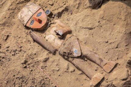
Archaeologists unearth 3,800-year-old wall relief in Peru
Wall carvings were found in what was once a fishing city of the Caral civilization, the oldest in the Americas. The relief is thought to symbolize a period of drought and famine brought on by climate change.
Archaeologists discovered an ancient wall relief in Peru, belonging to the oldest civilizations in the Americas, news agency Andina reported on Thursday. The wall is approximately 3,800 years old and portrays snakes and human heads.
One meter (3.2 feet) high and 2.8 meters long, the wall relief was discovered in the sea-side archaeological site of Vichama, 110 kilometres (68 miles) north of Peru’s capital, Lima.
The Vichama site is one of the excavation points of the recently discovered Caral civilization, also known as Norte Chico, and has been explored by archaeologists since 2007.
Aerial view of the Caral Archeological Area in the Supe valley
The Caral civilization is 5,000 years old, making it the oldest civilization in the Americas, and flourished at the same time as the thriving Mesopotamian, Egyptian and Chinese civilizations. The Caral people lived in the Supe Valley along the north-central coast of Peru.
Dating back to 1800 and 3500 B.C., Vichama is thought to have been a fishing community and one of the Caral peoples’ various cities. The wall was made of adobe, a clay-like material from which bricks are made and was located at the entry point of a ceremonial hall.
The snakes represent a water deity that lands on a humanoid seed
Documenting climate change
The wall relief shows four human heads, side by side, their eyes closed, with two snakes passing between and around them. The snakes point their heads to what appears to be a humanoid seed symbol that is digging into the soil.
Archaeologist Ruth Shady, who oversees the site and announced the discovery, hypothesized that the serpents represent a water deity that irrigates the earth and makes seeds grow.
Shady said the relief was likely done towards the end of a drought and famine that the Caral civilization experienced. Other reliefs discovered nearby showed emaciated humans.
Archaeologists believe that the relief discovery reinforces the notion that these early humans were attempting to depict the difficulties they faced due to climate change and water scarcity, which had a large impact on their agricultural production.
The Caral excavation site has so far unearthed the ruins of 22 buildings in a 25-hectare space, dating back to between 1800 and 1500 B.C.
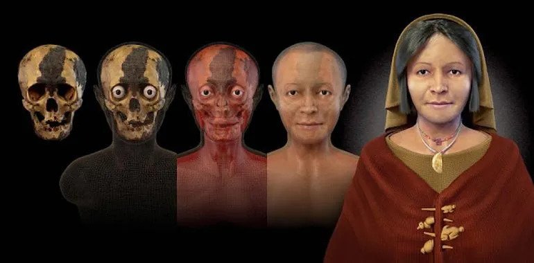
The face of a 4,500-year-old mummy found in Peru was digitally reconstructed
Last year, archaeologists came across a 4,500-year-old mummy of a woman at Aspero, in Peru – and she was given the moniker of the ‘Lady with the Four Brooches’. Now to put things into perspective, this ‘new world’ discovery is almost as old as the Great Pyramid of Giza, thus shedding light on the intricacy of the pre-Columbian civilizations of America.
And now, a collaborative effort from researchers (at Caral Archaeological Zone or ZAC and Inca Garcilaso de la Vega University or UIGV) has resulted in the reconstruction of the face of the ‘Lady with the Four Brooches’, with the incredible recreation being unveiled at the Ministry of Culture in Lima, on 11th October.
The reconstructed visage represents a middle-aged woman (40-50 years old and around 5 ft tall) with simple features and a benign, almost-affectionate bearing. However, there was more to this ancient lady than her gentle face suggests. According to Dr Ruth Shady, director of ZAC –
It’s exciting to see the computer-generated 3D image of a person who we believe was a noblewoman with important social standing and authority in the ancient Caral civilization. Her discovery refers to the four brooches or ‘cuatro tupus’ carved from animal bones and shaped like monkeys and birds, that were found pinned to the fabric covering her remains. We know that these ornamental fasteners were used by women of prestige in traditional societies as symbols of their affluent social status. By revealing this ancient female’s face, we can throw some light on an intricate culture that supported gender equality, allowing both men and women to hold, political, religious and leadership roles.
Now as for this reconstruction, the process was not without its fair share of hiccups. For starters, the researchers had to deal with a missing eye. Furthermore, the mummy’s cranium was also severely deformed, possibly due to intentional ritual cranial distortions followed by some ancient Andean civilizations (for reasons still unknown). In any case, the scientists could figure out other aberrations, like three fractures on her skull that might have been caused by a fall.
Brazilian 3D computer graphic artist, Cicero Moraes, who was a part of the digital reconstruction process said –
There was a dark mass obscuring the skull’s left eye socket which was partly caused by decaying body tissues and remnants of the funeral blanket covering the corpse. Photogrammetry can only take 3D photographic scans of the outside of the object, so I digitized the skull as it was and found an ingenious way to fill in the gap. I simply mirrored the right eye orbit and copied it to the left side. I was able to soften the jawline by giving it a more feminine pointed chin.
He also talked about how the artists recreated the various facial features complemented by the different density parameters –
Working with a disfigured skull is always a challenge as there is very little data to use as a reference. I compared the ‘Lady’s’ skull with a modern woman of compatible ancestry and age. By overlapping the structures, you could see how the jaw on the ancient skull was more robust and square compared to the recent skull. I reconstructed the face by working with the anatomical distortion while referencing the modern skull. I also used data tables which give the standard density of skin tissue, muscles and fat on various sections of the head.
Coming to the historical scope of the ‘Lady with the Four Brooches’, the find hailed as one of the most important archaeological discoveries of 2016, pertained to an entombed body discovered inside a burial chamber in the Huaca of the Idols.
This fascinating structure entails one of the many pyramid-shaped buildings in the region designed with overlapping platforms and a central staircase (pictured below).
The deceased woman was flanked by objects like broaches with animal-shaped etchings, a necklace made of sea shells, and a pendant of Spondylus (bivalve molluscs). These jewellery items allude to her affluent social status, while also hinting at how high-end commodities and items were possibly traded between the coastal and inland settlements in pre-Columbian Peru.
Interestingly enough, the site of coastal Aspero in itself is only 14 miles away from inland Caral (or Caral-Supe), possibly the oldest known city in the Americas. This obviously brings us to the question – who were these ancient inhabitants of Peru who built impressive monuments and pyramids that were contemporary to their Egyptian counterparts? Well, the answer points to the so-called Norte Chico civilization, a factional conglomeration of around 30 major population centres, which was established along the region of north-central coastal Peru.
The Norte Chico thrived from 3500-1800 BC, thus making them the oldest known civilization in the Americas. And of the major cities (or probably the biggest one) of this conglomeration was Caral, a massive urban sprawl that covered 60 hectares of area, and was home to numerous temple complexes, and earthen mounds (pyramids), circular plazas and even a geoglyph.
Various carved objects were found in the tomb.
The main temple compound among these impressive architectural feats relates to the Templo Mayor, a massive complex encompassing an area of 150 m (492 ft) in length and 110 m (360 ft) in width (with an average height of 28 m or 92 ft), which is more than equivalent of three American football fields! Oddly enough, the commercial and economic aptitude required for these ambitious constructional endeavours was (probably) not fueled by wars and conquests on the part of the political elite. In that regard, much like the ancient Jomon people of Japan, the Norte Chico culture was not predisposed toward violence, as evidenced by the lack of warfare-based weapons, trauma-bearing skeletons and even human sacrifices (which possibly occurred in very rare instances).
In any case, there is still much to know about the Norte Chico (Caral) civilization of ancient Peru and the inter-relation between the coastal towns (like Aspero) and the inland cities (like Caral). Furthermore, there is also the angle of how women could achieve higher statuses within the society – as evidenced by this mummy in question. And lastly, a baffling element accompanies the architectural feats of the advanced civilization, and it pertains to how the Norte Chico didn’t dabble in either visual art or ceramic-based pottery.
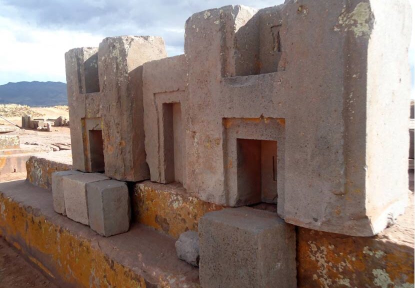
Enduring Mystery Surrounds the Ancient Site of Puma Punku
High up the Bolivian altiplano,’ south of Lake Titicaca and the ancient complex of Tiahuanaco, we find the ancient ruins of Puma Punku.
Believed to have been erected by the ancient Tiwanaku culture in the bronze age, between 1,000 and 2,000 years ago, the ancient site is home to some of the most fascinating ancient stone structures on the surface of the planet.
Shrouded in mystery, the archaeological site of Puma Punku is one of the biggest headaches for mainstream archaeologists who are unable to explain how ancient cultures cut and shaped granite stone to incredible precision, transported blocks of stones that weigh more than 50 tons, and placed them in a position like a puzzle so that not a single sheet of paper can fit between them.
But if that wasn’t enough of a mystery, there’s that LITTLE magnetic anomaly present at Puma Punku.
The question that arises here is… how on Earth did the ancients transport these massive blocks of stone, tens of tons in weight across 70 kilometres from their quarry to Puma Punku?
Puma Punku: reconstruction
The Magnetic Anomaly
This mysterious feature which makes Puma Punku even stranger was spotted by researcher and author Brien Foerster.
In a video uploaded onto his YouTube account, Brien Foerster takes us on a trip to the Bolivian Altiplano where he tours through Puma Punku and shows us how certain rocks at the site – Puma Punku’s Grey Stones – display magnetic anomalies.
These curious features have been completely ignored and left unattended by scholars who have studied Puma Punku in the past.
Here is another video where we can see the curious magnetic anomaly present on the grey stones of Puma Punku.
Still, think Puma Punku is just another ordinary ancient site? Think again.