Mummified remains of Incan ‘Princess’ who died 500 years ago finally returned to Bolivia
A 500-year-old mummy of an Incan girl has been returned to Bolivia some 129 years after it was donated to the Michigan State University Museum, marking what an official says is the first time human remains of archaeological importance have been repatriated to the Andean country.
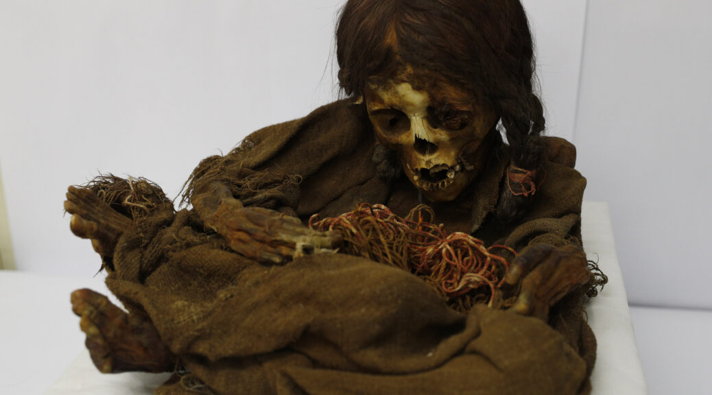
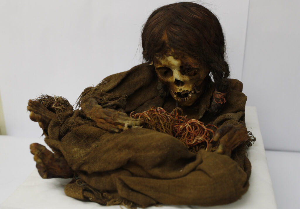
Known as Ñusta, a Quechua word for “Princess,” the mummy amazes many because of its excellent state of preservation: Its black braids seem recently combed and its hands still cling to small feathers.
Experts say the mummy originally came from a region in the Andean highlands near La Paz during the last years of the Inca civilization.
Radiocarbon tests also have revealed that it dates to the second half of the 15th century, confirming the likelihood that its tomb burial preceded the arrival of Christopher Columbus and the conquest of the Inca by the Spanish.
“Despite the fact that it was given the name Ñusta, or ‘Princess,’ we don’t know if she was really a princess. We will only be able to answer that with DNA studies,” said William A. Lovis, an MSU emeritus professor of anthropology who worked for years to help bring the remains home.
The mummy was returned more than two weeks ago with the assistance of the U.S. embassy in La Paz, and a new study is expected to be carried out by November by Bolivian academics and foreign experts. Until then, accompanying funerary objects will be exhibited to the public during a celebration that pays homage to the dead on Nov. 2.

Culture Minister Wilma Alanoca said that in recent years, the Bolivian government has achieved the repatriation of several archaeological goods that were taken illegally, but this is the first time that a body has been brought back.
“It’s the first time that a body has been recovered, a mummy from the Inca period,” she said.
Still, many mysteries remain unsolved.
The girl, who is thought to have been part of an ethnic Aymara group known as the Pacajes, had originally been placed in a stone tomb along with sandals, a small clay jar, pouches, feathers and several types of plants including maize and coca—perhaps because some Andean civilizations believed that offerings helped the dead transition into the next life.


“It’s possible that the girl was an important person and that the objects placed with her had as much sacred importance as they had a useful purpose,” said Lovis. “Another possibility is that her death was an Inca sacrifice to appease or an offer to Inca deities.”
Ñusta is believed to have been about 8 years old when she died and was buried in a dress made with threads from llama or alpaca, animals which were domesticated more than 4,000 years ago in the Andes and still roam the highlands of Bolivia, Peru, Argentina and Chile.
David Trigo, who heads the National Archaeology Museum in La Paz, said the well-kept objects open new doors into a society that has barely been studied.
“We can say that she was an important member of her ethnic group,” Trigo said, referring to Incan and Aymara traditions of building adobe or stone tombs known as chullpa for elite members of their communities.
For now, the remains are being preserved in a refrigerated chamber at the National Archaeology Museum in downtown La Paz.