The secret of the mummy in the Crystal coffin found in a garage in San Francisco
Mysterious mummies are a symbol of ancient lost times, which we often associate with Egypt and other ancient civilizations. Therefore, the discovery of a coffin made of crystal with the body of a girl come from under the floor of a garage in San Francisco is absolutely shocking.
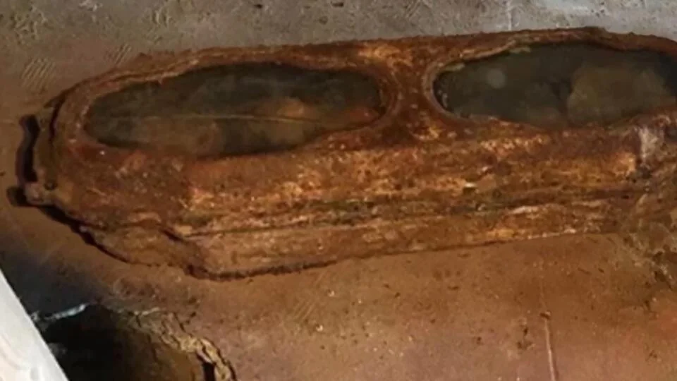
In 2016, while remodeling an old garage in San Francisco, California, workers found a strange object that, upon closer inspection, turned out to be a child’s coffin with an extraordinary design.
Rusted bolts held a metal object together that resembled a large shaped casket, and it was only by unscrewing the bolts that it was possible to identify what it was. Bolts fixed a sheet of metal that covered two windows made of thick glass. Looking inside the box, the workers were taken aback — inside lay the body of a small blonde girl, almost untouched by decay.
The discovery of an old coffin containing the body of a child terrified the people of San Francisco and perplexed scientists. It took them a long time to figure out the mystery of an unusual burial.

In the coffin inside lay the body of a blond girl dressed in a lace dress. Her hair was decorated with lavender petals, and on her chest lay a wreath in the form of a cross of blue bindweeds. In her hands, she held a large purple nightshade flower.
There were no details inside the coffin that would help identify the body. The body was examined, described, and photographed, after which the experts drew up a protocol, placed the metal coffin containing the child in a wooden box, and… handed it over to the garage owner. According to the law, if the corpse is not a criminal and the relatives are unknown, the burial duties are assigned to the owner of the land where the body was discovered.
During the paperwork, the police gave the deceased the name Eva. And the mistress of the garage, where they found the burial, named the child Miranda.

But how did the coffin with the little dead girl end up under the garage? This was not a surprising occurrence given that the structure stood on the grounds of Odd Fellows Cemetery, San Francisco’s largest cemetery. When the rapidly growing metropolis came close to the extreme graves, a large city churchyard was closed for burials in 1890.
When the cemetery started to negatively impact the neighborhood over time, it was decided to close it down in 1923. Most of the remains were exhumed and buried in common graves, while some of the bodies were taken by relatives for reburial. The coffin with the girl was obviously forgotten in the confusion and remained in the ground, which was handed over to developers.
Tissue and hair samples were taken from the deceased girl for DNA analysis. Erica Karner was busy burying Eva-Miranda while the examination was taking place. The girl’s body began to decompose after the airtight coffin was opened. It was impossible to delay the burial.

Tissue analysis revealed that the baby’s mother was born in the British Isles. Even more interesting were the results of the hair study.
“Hair DNA analysis showed that the child had a protein deficiency and severe malnutrition.
And experts said that most likely this arose due to some kind of illness or due to the amount of medication that the child used,” the lawyer said.
Volunteers explored the city archives. They found a record of the burial of a two-year-old girl who died due to severe exhaustion. Her name is Edith Howard Cook. The child died in October 1876.
The parents’ names were Horatio Nelson and Edith Skaufi Cook. Scientists have even found living relatives of the “girl from the crystal coffin.”
Thus, volunteers and scientists were able to solve the mystery surrounding the mysterious burial and give the girl’s name back who passed away nearly 150 years ago.

Parents often embalmed their dead children’s bodies centuries ago. The famous mummy of a child is kept in Palermo’s Capuchin catacombs. Rosalia Lombardo, the daughter of a Sicilian official, died of pneumonia in 1920. The girl’s body was so well preserved that she was nicknamed “Sleeping Beauty”.