Category Archives: U.S.A

‘Exceptionally Rare’ Dinosaur Fossil Found in Maryland

‘Exceptionally Rare’ Dinosaur Fossil Found in Maryland

‘Exceptionally Rare’ Dinosaur Fossil Found in Maryland

A group of paleontologists and volunteers discovered several rare fossils, along with the largest theropod fossil ever found in Eastern North America.

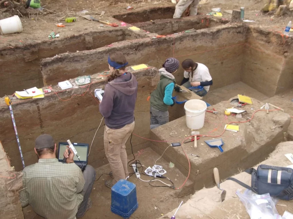
The find was made at Dinosaur Park, Maryland, in April 2023. The site has seen the discovery of amazing fossils since the 19th century, but this recent find was described by Matthew Carrano, a paleontologist at the Smithsonian, as “exceptionally rare.”

Dinosaur Park discovery

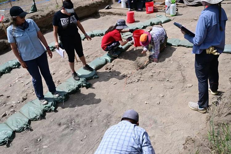
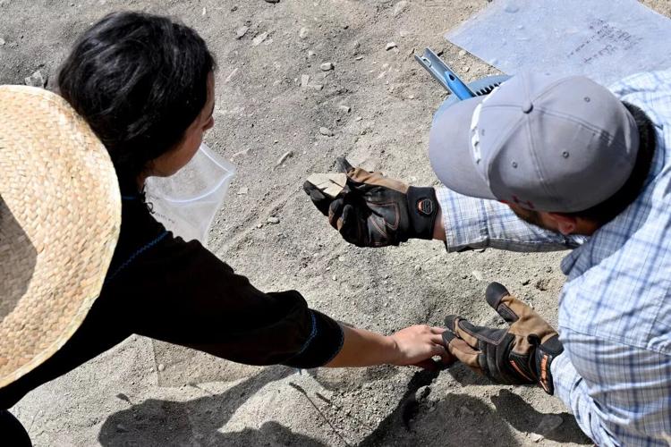
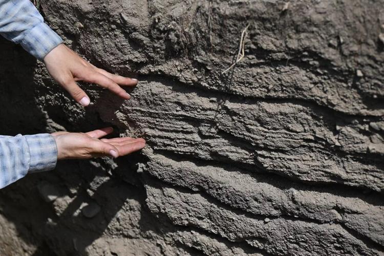
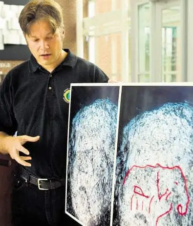
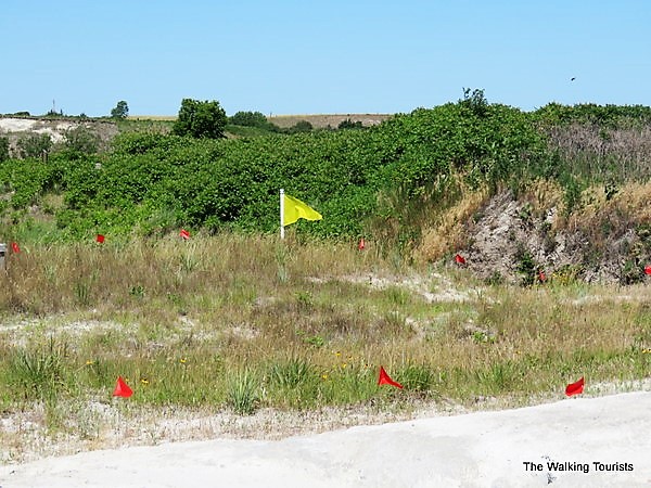
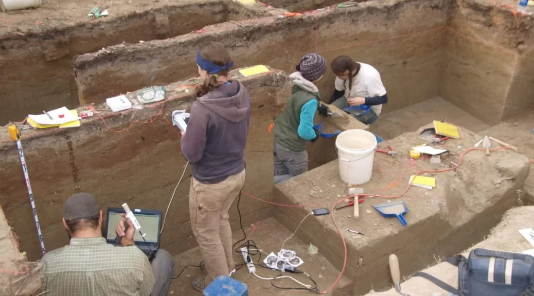
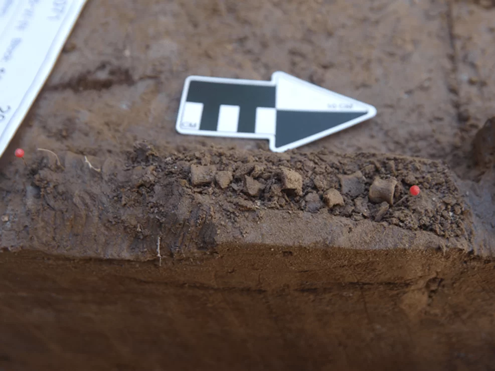
At Dinosaur Park in Prince George’s County, Maryland, paleontologists and volunteers discovered a three-foot-long fossil. This fossil was found at what had been classified as a “bonebed,” a term used by paleontologists to describe a layer with contents that date to the same geologic period. The bonebed discovered was the first found in Maryland since 1887.

JP Hodnett, program coordinator and paleontologist at Dinosaur Park, said, “Finding a bonebed like this is a dream for many paleontologists as they can offer a wealth of information on the ancient environments that preserved the fossils and provide more details on the extinct animals that previously may have only been known from a handful of specimens.”

Workers at the bonebed where the Acrocanthosaurus fossil was discovered.

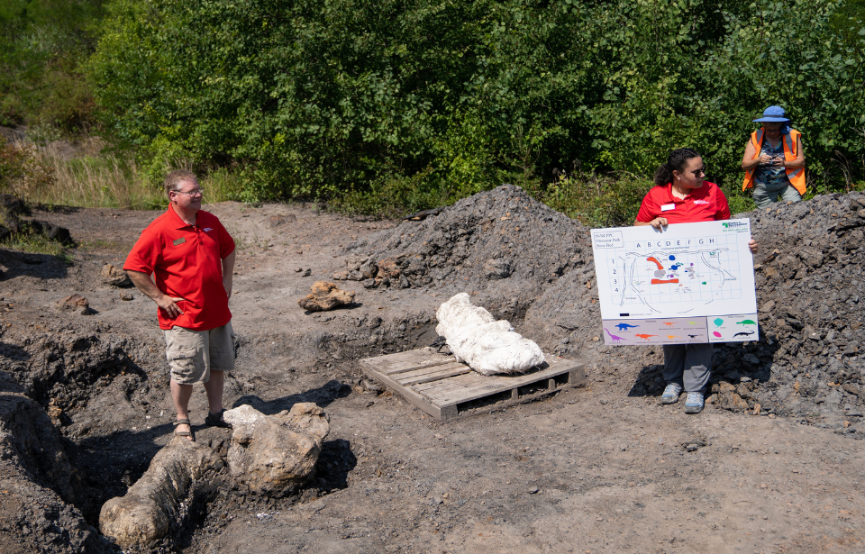
Hodnett concluded: “Most paleontologists have to travel across the country or go overseas to find something like this, so having this rare find so close to home is fantastic.”

What was discovered was a three-foot-long shin bone which is believed to have belonged to a theropod.

A theropod is a carnivorous, bipedal, saurischian dinosaur, which is characterized by hollow and thin-walled bones. These dinosaurs had shorter forelimbs with three clawed digits.

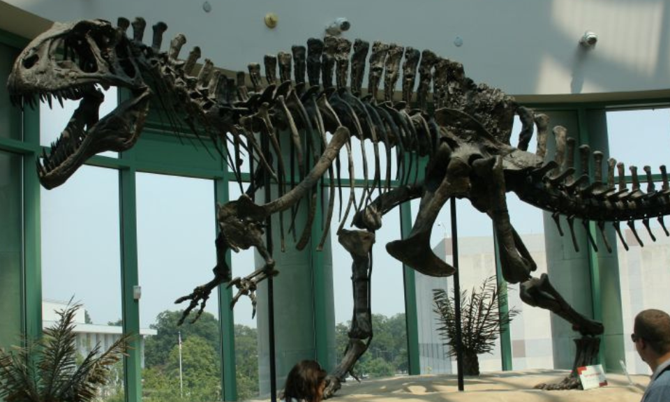
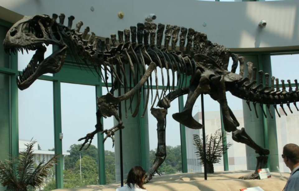
The fossil is believed to be from an Acrocanthosaurus, the largest theropod of the Early Cretaceous period. Thomas Holtz, a paleontologist at the University of Maryland, said, “The dinosaur site at Laurel is by far the most important dinosaur dig site in America east of the Mississippi… It gives us insights into the diversity of animals and plants at a critical period in Earth’s history.”

Acrocanthosaurus

Acrocanthosaurus is a genus of theropod dinosaur that lived during the Early Cretaceous period, approximately 113 to 110 million years ago. It was a large carnivorous dinosaur that belonged to the family Carcharodontosauridae, which includes other notable predators like Tyrannotitan and Giganotosaurus.

Acrocanthosaurus was named for the distinctive high spines running along its back, which gave it a unique appearance. These spines, coupled with its robust build and powerful jaws, indicate that it was a formidable predator. It measured around 36 to 38 feet in length and weighed an estimated 4.4 to 6.6 metric tons.

Acrocanthosaurus restoration.

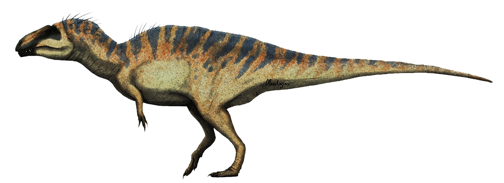
One of the most remarkable aspects of Acrocanthosaurus is its skull, which was long, narrow, and filled with sharp, serrated teeth. These teeth were well-suited for gripping and tearing flesh, indicating that it was an efficient hunter. Additionally, its forelimbs were relatively short compared to its hind limbs, suggesting that Acrocanthosaurus was likely a bipedal dinosaur.

Other fossils of Acrocanthosaurus have been discovered in what is now North America, primarily in the United States. The first remains of this dinosaur were found in 1940 in Oklahoma, and subsequent discoveries have helped paleontologists gain a better understanding of its anatomy and behavior.

Due to the incomplete nature of the fossil record, some aspects of Acrocanthosaurus’ life remain uncertain. However, based on its physical characteristics, scientists believe that it was an apex predator that likely preyed upon large herbivorous dinosaurs, such as sauropods and ornithopods.

Ryan McLachlan is a historian and content writer for Hive Media. He received his Bachelor of Arts in History and Classical Studies and his Master of Arts in History from the University of Western Ontario. Ryan’s research focused on military history, and he is particularly interested in the conflicts fought by the United Kingdom from the Napoleonic Wars to the Falklands War.

Ryan’s other historical interests include naval and maritime history, the history of aviation, the British Empire, and the British Monarchy. He is also interested in the lives of Sir Winston Churchill and Admiral Lord Nelson. Ryan enjoys teaching, reading, writing, and sharing history with anyone who will listen.

In his spare time, he enjoys watching period dramas such as Murdoch Mysteries and Ripper Street and also enjoys reading classical literature and Shakespeare. He also plays football and is an afternoon tea connoisseur.

An Underground City Full of Giant Skeletons Discovered in the Grand Canyon

An Underground City Full of Giant Skeletons Discovered in the Grand Canyon

In the early 20th century, chance led us to the gates of the underground city of giants best known in those days. It was an amazing discovery in the Grand Canyon and the press soon echoed.

An Underground City Full of Giant Skeletons Discovered in the Grand Canyon

The Grand Canyon was the birthplace of a culture in which people of Cyclopean proportions existed according to an article published in the Gazeta de Arizona on April 5, 1909.  A civilization that only left us some structures as a testimony of its existence. 

The article mentions the discovery of a huge subterranean citadel by an explorer named GE Kinkaid, who accidentally found it while rafting on the Colorado River. It is worth mentioning that Kinkaid was a recognized archaeologist and had the financial support of the Smithsonian Institution.

According to their descriptions, the entrance to this mysterious city was at the end of a tunnel that extended for something more than 1600 meters underground.

Kinkaid was impressed that the cavern was almost inaccessible. The entrance was about 450 meters under the wall of the steep canyon. The place was in a zone protected by the government and the access was penalized under fine.

“Above a shelf that could not be seen from the river was the entrance to the cave. When I saw the chisel marks on the wall inside the entrance, I got interested, I got my gun and I went in. “Kinkaid said.

The architecture found suggested that the builders of that subterranean city possessed advanced engineering skills.

The central axis of the underground city made it a gigantic camera from which radiated passages similar to the radii of a wheel.

The walls of the main chamber were adorned with copper weapons and tablets covered with symbols and hieroglyphic characters very similar to those we know in Egypt.

Another interesting finding was the discovery of mummified bodies inside the citadel. None of the mummies found were less than 2.74 meters and all were wrapped in dark linen. Kinkaid said he had taken photographs of one of them with a flashlight, however, none of those photos were found.

Further explorations revealed interesting data on the beliefs of these alleged giants of the city.

More than 30 meters from the entrance is a room with a cross-shaped plant several tens of meters long and where an idol was found that could have been the main god of his religious system.

He was sitting cross-legged and with a lotus or lily flower in each hand. His face had oriental features as well as the carving of the cave. This idol had a certain resemblance to Buddha, although the scientists of the time did not finish assuring that it represented that religious cult.

The article also talks about the discovery of ceramics and other artifacts with trademarks having been manufactured in other parts of the world. Perhaps a rare mixture of cultures scarcely occurs in archaeological finds, so this discovery would be of unprecedented importance.

The last camera they found on the exploration was what Kinkaid and his partner, Professor SA Jordan, a ceremonial crypt, believed to be at the end of the great hall where they found the mummies.

Unfortunately, the article does not give many more details about this discovery. Nor are there any official versions or references to this enigmatic subterranean city. 

The Smithsonian Institute denies having knowledge of the existence of this underground city.

The Nine Mile Canyon In Remote Utah Is The World’s Largest ‘Art Gallery

The Nine Mile Canyon In Remote Utah Is The World’s Largest ‘Art Gallery’

The Nine Mile Canyon In Remote Utah Is The World's Largest 'Art Gallery'
Nine Mile Canyon

The Nine Mile Canyon located in the desert of eastern Utah is the world’s longest art gallery in the world. This canyon boasts tens of thousands of petroglyphs and pictographs along a stretch of 40 miles.

The art in the canyon was created by the Fremont culture and the Ute people and depicts everything from local wildlife to cultural displays and beliefs. As you can imagine, this site of over 10,000 images is a treasure trove of information for archaeologists and an opportunity for tourists to step back in time a thousand years ago.

Nine Mile Canyon Petroglyphs

In the 1880s, this canyon was used to transport goods through the eastern Utah mountains. A road was constructed through the canyon in 1886 to connect Fort Duchesne to the railroad line located in Price, Utah. However, today the canyon is primarily visited by tourists interested in learning more about the Ute and Fremont people.

Nine Mile Canyon lies in eastern Utah

The area is currently being appraised for the natural gas that lies within the Tavaputs Plateau. Development of this natural gas resource could impact local art, causing ongoing debates on how best to proceed.

The canyon formed from the small Nine Mile Creek, a tributary of the larger Green River which emptied into Desolation Canyon. Although the creek is not a major body of water, it is one of the few year-round and reliable sources of water in an otherwise desert climate.

Nine Mile Canyon Petroglyphs

The Nine Mile Canyon consists of interbedded sandstone, mudstone and shallow water limestone. The changes in rock type record changes in the expansion and contraction of the ancient Lake Uinta.

The Green River Formation, which sits higher than the sandstone units used for petroglyphs is an Eocene sedimentary group. The formation is located in Colorado, Wyoming, and Utah in the location of Nine Mile Canyon.

The Green River Formation is the largest oil shale in the world with an estimated reserves of up to 3 trillion barrels of oil. This is larger than the entire oil resource in Saudi Arabia and holds a significant portion of the United States oil resources.

Nine Mile Canyon in Eastern Utah

Why, then, have you likely never heard of the Green River Formation and oil and gas development therein? The hydrocarbons in the Green River Formation are in a solid form (as opposed to liquid or gaseous for most hydrocarbon development), which poses significant issues with development. In order to unlock the oil one must heat the shale and essentially “cook” out the hydrocarbons, an incredibly expensive process.

In total, there are 10,000 individual images within Nine Mile Canyon located at over 1,000 archaeological sites. Many of the depictions were produced by the Fremont from 950 to 1250 AD.

The Fremont, advanced for their time, practiced established agriculture, growing crops of corn and squash in the canyon floor. The Fremont build irrigation ditches along the canyon edges as a way to divert water to crop areas.

Nine Mile Canyon Petroglyphs

As we step forward to the 16th century the Utes dominated the region and added to the rock art that was previously created by the Fremont.

Several hundred years later in the late 19th century, there is first mention of the Nine Mile Canyon in journals of American fur traders.

The petroglyphs and pictographs are carved and painted on an easily weathered sandstone, making the depictions vulnerable to destruction.

The walls of the canyon are adorned with hunting scenes and a wide array of animals including birds, sheep, bison and lizards.

In 2004 the Nine Mile Canyon included on the National Trust for Historic Preservation list of America’s Most Endangered Places. This was largely due to increased natural gas development in the area and tourist activity.

Nine Mile Canyon Petroglyphs

Newly unearthed 6,000-year-old archeological site

Newly unearthed 6,000-year-old archeological site

Newly unearthed 6,000-year-old archeological site
Dr. Shannon Tushingham, left, watches Monday as Washington State University students work at an archaeological excavation of prehistoric earth ovens near Newport, Wash.

The Kalispel Tribe has uncovered evidence of ancient earth ovens on the bank of the Pend Oreille River believed to be 6,000 years old. Archaeologists are excavating the earth ovens, a cluster of rocks that were used for cooking in fire pits.

Shannon Tushingham, an archaeology professor from Washington State University who has worked with the tribe for many years, is leading the excavation.

“This is some of the oldest technology used by humans to cook food anywhere in the world,” Tushingham said. “And here, we have some of the oldest ovens in North America.”

Linda McNulty Perez, a graduate student at Princeton and WSU student Chris Arriola work at an archeological excavation underway of 5,000-year-old earth ovens on Monday, June 5, 2023, near Newport, Wash.

The Kalispel Tribe recently purchased the land northwest of Newport to build additional housing for tribal members near the reservation. The fire-cracked rocks were discovered about 4 feet under the surface as part of a standard site exploration, testing soil quality and searching for possible artifacts such as these.

“It makes me feel proud,” said Curt Holmes, vice chairman of the tribal council. “We’ve been here for a long time.”

Geoarchaeologist Naomi Scher shows layers of sediment at the site of an archaeological excavation of prehistoric earth ovens on Monday near Newport, Wash.

Holmes said the housing is urgently needed.

The tribe is outgrowing its tiny reservation. Membership has more than doubled since Holmes became a council member in 1994, he said. Today there are 490 members, and 70 are on a waiting list for housing.

The research team is working quickly to make way for the seven houses that will soon be built on the site.

The project could reveal new insights into the foods the Kalispel people have been preparing and eating for millennia.

“As a tribe, we’ve never shared this kind of historical excavation experience with the public,” said Kalispel elder Shirley Blackbear. “But I think it is important for non-Natives to learn and understand more about our tribe. Our history and traditions are very rich and important to us. Cooking techniques have been passed down from generation to generation.”

Similar ovens have been found throughout the area along the Pend Oreille, Tushingham said.

Initial carbon dating results show the site was repeatedly used from 6,000 to as recently as 700 years ago.

“There is something special about this place that people kept coming back to,” Tushingham said. “That is something we are trying to figure out.”

A possible explanation is that sandy soils made it easy to dig pits for the ovens.

“That is a fairly continuous history of food processing on the same land that speaks to both ecological and cultural stability,” said Kevin Lyons, Kalispel tribal archaeologist.

The archaeologists don’t know yet exactly what people were eating here, but these types of ovens were often used to harvest camas, a tradition the tribe continues today.

Lyons described the oven technique as digging a soup bowl shape out of the earth, then lining it with fuel and capping it with rocks.

They might wrap camas or other food in a nonburnable layer, like skunk cabbage, and set it on the rocks. Then they would light the fuel and cover the oven with soil, leaving vent holes, to bake.

After about three days, the camas would change to a sweet caramel flavor that would go well with dried meat and berries.

The researchers will take samples back to the lab to look for proteins and microscopic food residues. Tushingham is using the dig to teach more than a dozen students from across the U.S. and Canada.

“We haven’t been able to have field schools for a long time because of COVID,” she said. “So people are really hungry to learn these techniques.”

It’s a great opportunity for students to learn how to work with tribal communities, Tushingham added.

“Archaeology is our history,” said Daulton Cochran, an undergraduate from the University of Arkansas and a member of the Cherokee Nation. “It’s something that doesn’t get looked at a lot, so I like being one of the people to uncover the past.”

A ‘Stonehenge-Like’ Structure Exists In Lake Michigan and is 9,000 Years Old

A ‘Stonehenge-Like’ Structure Exists In Lake Michigan and is 9,000 Years Old

While scanning underneath the waters of Lake Michigan for shipwrecks, archeologists found something a lot more interesting than they bargained for.

While scanning underneath the waters of Lake Michigan for shipwrecks, archeologists found something a lot more interesting than they bargained for: they discovered a boulder with a prehistoric carving of a mastodon,  as well as a series of stones arranged in a Stonehenge-like manner.

Gazing into the water

Using remote sensing techniques is common in modern archaeology – scientists routinely survey lakes and ground for hidden structures.

At a depth of about 40 feet into Lake Michigan’s Grand Traverse Bay, using sonar techniques to look for shipwrecks, archeologists discovered sunken boats and cars and even a Civil War-era pier, but among all these, they found this prehistoric surprise, which a trained eye can guess by looking at the sonar scans photos in this article.

“When you see it in the water, you’re tempted to say this is absolutely real,” said Mark Holley, a professor of underwater archaeology at Northwestern Michigan University College who made the discovery, during a news conference with photos of the boulder on display in 2007. “But that’s what we need the experts to come in and verify.

The boulder with the markings is 3.5 to 4 feet high and about 5 feet long. Photos show a surface with numerous fissures.

Some may be natural while others appear of human origin, but those forming what could be the petroglyph stood out, Holley said.

Viewed together, they suggest the outlines of a mastodon-like back, hump, head, trunk, tusk, triangular-shaped ear, and parts of legs, he said.

“We couldn’t believe what we were looking at,” said Greg MacMaster, president of the underwater preserve council.

Specialists shown pictures of the boulder holding the mastodon markings have asked for more evidence before confirming the markings are an ancient petroglyph, said Holley.

“They want to actually see it,” he said. Unfortunately, he added, “Experts in petroglyphs generally don’t dive, so we’re running into a little bit of a stumbling block there.”

If found to be true, the wannabe petroglyph could be as much as 10,000 years old – coincident with the post-Ice Age presence of both humans and mastodons in the upper midwest.

The formation, if authenticated, wouldn’t be completely out of place. 

Stone circles and other petroglyph sites are located in the area.

The discovery was made back a few years ago, and surprisingly enough the find hasn’t been popularized at all, with little to no information available online, but I’ll be sure to update this post as soon as I can get ahold of more info. So, who’s from Michigan?

Hundreds of Well Preserved Prehistoric Animals have been found in an Ancient Volcanic Ashbed in Nebraska

Hundreds of Well Preserved Prehistoric Animals have been found in an Ancient Volcanic Ashbed in Nebraska

An adult (3) rhino fossil lies next to a baby’s fossils. They are among hundreds of skeletons discovered at Ashfall Fossil Beds State Historical Park in Royal, Nebraska.

The watering holes attracted prehistoric animals among Nebraska’s tall grasslands. From horses to camels and rhinoceroses, with wild dogs looming nearby, animals roamed the savanna-like region.

Then, one day, it all changed. Hundreds of miles away, a volcano in southeast Idaho erupted. Within days, up to two feet of ash covered parts of present-day Nebraska.

Some of the animals died immediately, consumed with ash and other debris. Most of the animals lived for several more days, their lungs ingesting ash as they searched the ground for food. Within a few weeks, northeast Nebraska was barren of animals, except for a few survivors.

More than 12 million years later, a fossil was found in Antelope County, near the small town of Royal.

The skull of a baby rhino was discovered by a Nebraska paleontologist and his wife while exploring the area. The fossil was exposed to erosion. Soon after, exploration started in the area.

As more discoveries were made, the site grew into a tourist attraction. Today, people visit Ashfall Fossil Beds State Historical Park to check out hundreds of fossils from 12 species of animals, including five types of horses, three species of camels, as well as a saber-toothed deer. The infamous saber-toothed cat remains a dream discovery.

Visitors view fossils inside the Hubbard Rhino Barn, a 17,500-square-foot facility that protects the fossils while allowing visitors to roam on a boardwalk. Kiosks provide information on fossils located in specific areas.

One level of the fossil beds was discovered at Ashfall Fossil Beds Park.

As you tour the barn, if a summer intern or paleontologist is nearby, they are open to discussing their work, as well as answering questions. During our visit, we learned that an intern had discovered a fossilized dog paw print.

Outside the barn, visitors can read facts about the area, including that mammoths migrated to North America about 1.5 million years ago.

A yellow flag in an area a short distance from the main walk to the barn indicates the discovery site of the rhino skull. Red flags showcase spots where additional fossils were discovered.

A yellow flag marks the site of the first skull discovery in 1971. The red flags indicate spots of additional fossil finds.

Visitor activities and views at Ashfall Fossil Beds

In addition to the Hubbard Barn, Ashfall Fossil Beds features a discovery area where children can cipher through the sand searching for their own fossil discoveries. A small barn is used for special exhibits, as well as classes.

Children play in a sandbox “searching” for fossils.

The visitors center houses some animal remains, as well as paleontologists working on recent finds. About 60 million years before the area was home to the savanna, Nebraska was part of a tropical sea.

Fossils found in the area include a plesiosaur, a mammal from the Jurassic Period. The fossils displayed were found on the Santee reservation, about an hour away.

Fossils from a plesiosaur were found near Santee, about an hour from the park.

Sculptures representing animals from the region are located around the state historical park. Ashfall Fossil Beds State Historical Park kicks off its summer hours on Memorial Day weekend when it’s open daily through Labor Day. Otherwise, check the website here for hours.

A state park permit ($6 per vehicle for an in-state day permit or free with an annual pass) is required for visiting the park, in addition to the $7 entrance fee.

A new study shows Early Native Americans in Alaska were freshwater fishermen 13,000 years ago

A new study shows Early Native Americans in Alaska were freshwater fishermen 13,000 years ago

A new study shows Early Native Americans in Alaska were freshwater fishermen 13,000 years ago

A team led by the University of Alaska Fairbanks researchers has discovered the earliest known evidence that Native Americans living in present-day central Alaska may have begun freshwater fishing around 13,000 years ago during the last ice age.

Ancestors of Alaska Natives, many of whose livelihoods still depend on freshwater fish such as salmon, may have started subsistence fishing as a response to fewer food resources during long-term climate change, Ben Potter and colleagues say.

The research offers a glimpse at how early humans used a changing landscape and could offer insight for modern people facing similar changes.

“We are looking at humans as ecologists do, as biologists do,” said Ben Potter, a UAF anthropology professor and co-lead author of the paper. “Even very early on, they are able to adapt to changing conditions.”

The study, published recently in the journal Science Advances, shows that people living between 13,000 and 11,500 years ago in what is now Interior Alaska relied on freshwater fish like burbot, whitefish and pike for food. The study builds on earlier UAF findings that documented salmon fishing by the same population of ancient humans.

Native Americans have relied on freshwater fish for thousands of years, but the origins of fishing in North America have been uncertain. Beringia, a region comprising present-day Alaska and Russia, was largely ice-free during the last ice age and is considered a key gateway to the Americas.

Burbot vertebrae from the Mead site are lined up.

“That discovery was really surprising because it was far from the ocean, in an area near the edge of salmon habitat,” said Potter. “That started us thinking: This could be a whole other angle on human ecology beyond large mammal hunting.”

To investigate, Potter et al. used a combination of DNA and isotope analyses to identify 1,110 fish specimens recovered from six human settlement sites – including in the Tanana, Kuskokwim, Susitna, and Copper River basins – in what was once eastern Beringia (central Alaska). They identified four main fish taxa – salmon, burbot, whitefish, and northern pike – whose earliest appearances dated to around 13,000 and 11,800 years ago.

These findings, along with well-documented fishing records from local Native Alaskans, suggest that early Native Americans may have started fishing as a response to environmental change during the Pleistocene-Holocene transition. “Our data collectively suggest that changes in climate and ultimately key mammal resources during the Younger Dryas led to human responses of widening diet breadth to incorporate multiple species of freshwater and anadromous fish, setting a pattern that would be expanded upon later in the Holocene as fish, particularly salmon, became key resources to Alaska Native lifeways,” the authors write.

The bones were found inside homes and hearths and tended to be associated with base camps, rather than short-term hunting camps. They also were far from lakes and streams, so it’s unlikely that predators moved them.

The absence of fishhooks or spears at the sites suggests that the early Alaskans likely used nets and perhaps weirs to harvest the fish.

“This is a compelling, evidence-based case for freshwater fishing at the end of the last Ice Age,” Potter said.

Until the beginning of the Younger Dryas, people relied more on waterfowl to augment large game like bison and elk. When temperatures started dropping around 13,000 years ago, that changed.

“While we don’t know why the use of waterfowl diminished, we know that the climate was changing,” Potter said. “One of the ways the people were able to adapt is to incorporate these new species and new technologies. Burbot, in particular, can be caught in late winter and early spring, when food resources were most scarce.”

The solid tie to modern subsistence activities is also compelling, he said.

Archeologists find remains of an underwater hospital and cemetery

Archeologists find remains of an underwater hospital and cemetery

Archeologists find remains of an underwater hospital and cemetery
University of Miami graduate student Devon Fogarty examines the headstone of John Greer who died while working at Fort Jefferson on Nov. 5, 1861. The gravesite is now completely underwater.

Archeologists at Dry Tortugas National Park have found remains of a 19th-century quarantine hospital and cemetery on a submerged island. The National Park Service said in a news release that records indicate dozens of people, mostly U.S. soldiers stationed at Fort Jefferson, may have been buried there.

The small quarantine hospital was used to treat patients with yellow fever at the fort between 1890 and 1900, according to the NPS.

Major outbreaks of the disease killed dozens, but the quarantine hospital offered a place to isolate patients, likely saving hundreds of lives.

While most buried in the Fort Jefferson Post Cemetery were military members, several were also civilians.

During a survey of the area, researchers found John Greer’s grave, prominently marked with a large slab of greywacke carved into the shape of a headstone and inscribed with his name and date of death.

According to the NPS, Greer was employed as a laborer at the fort and died there on Nov. 5, 1861.

“This intriguing find highlights the potential for untold stories in Dry Tortugas National Park, both above and below the water,” project director Josh Marano said.

“Although much of the history of Fort Jefferson focuses on the fortification itself and some of its infamous prisoners, we are actively working to tell the stories of the enslaved people, women, children, and civilian laborers.”

Efforts to learn more about those buried in the cemetery are ongoing.