Here is the list of top 10 Archaeological Discoveries of 2021
Archaeology is the closest thing we have to a time machine. Instead of using flux capacitors, however, archaeologists rely on technology like ground-penetrating radar, scanning electron microscopes, DNA sequencing, and of course, the good-old-fashioned shovel.
Equipped with the right tools and techniques, the work of these scientists allows us to reconstruct the past and imagine things as they once were.
Years from now, when we look back on the year that was 2021, archaeology won’t be the first thing that comes to mind. But that’s not to say it wasn’t a good year for this important scientific discipline, here is the list of the 10 most prominent archaeological discoveries to hit the headlines in 2021.
10. Slave Tag

A tag worn by an enslaved person who was hired out by his or her enslaver has been discovered in the remnants of a mid-nineteenth-century kitchen on the campus of the College of Charleston. Such tags, which were issued from the late eighteenth century until 1865, bore registration numbers and identified enslaved people by their trades, such as carpenter, blacksmith, fisherman, or domestic servant. This example, badge number 731, dates to 1853 and is stamped with the word “servant.”
While other southern cities had similar hired labour arrangements, Charleston is the only one that produced such tags, says archaeologist R. Grant Gilmore III of the College of Charleston. “What is uncommon about this discovery is that this object was found in context, unlike many other examples now in the hands of private collectors that have no provenance,” he says. “An enslaved person living in the house may have discarded the tag in the hearth, or someone on loan from across town may have lost it one day.” Property records for the kitchen and those who worked in it may help connect the object with specific enslaved individuals. “These objects are emblematic of urban slavery and the way it worked in Charleston,” says Bernard Powers, a College of Charleston historian. “You have a designation of an occupation and a connection to an individual that breaks through an amorphous group of enslaved humanity and allows for an identity and a personhood to emerge.”
9. Crusader Mass Grave

A mass burial containing the remains of at least 25 soldiers who were killed defending Christian-held Sidon during the Crusades was uncovered during excavations close to the town’s Saint Louis Castle. Archaeologists uncovered a belt buckle of a style worn by French-speaking Crusaders, as well as a coin dating to between 1245 and 1250. These objects led them to conclude that the men were likely killed during a 1253 attack by an army of the Mamluk Sultanate, an Islamic empire that spanned Egypt, much of the Levant, and part of the Arabian Peninsula from 1250 to 1517. Bournemouth University archaeologist Richard Mikulski says the large number of wounds to the men’s necks suggests they were killed by assailants on horseback wielding heavy medieval weapons, such as swords, axes, and war clubs or maces, possibly while fleeing. This is one of only two archaeologically documented mass burials of Crusaders. “For a period that is meant to be so full of violence and conflict,” says Mikulski, “we actually have very little physical evidence of battle from the Crusades.”
8. When the Vikings Crossed the Atlantic

When a settlement at L’Anse aux Meadows, at the northern tip of Newfoundland, was first excavated in the 1960s, the style of its buildings made clear they were constructed by Vikings who had arrived from Greenland in the tenth or eleventh century. But exactly when they made their voyage, becoming the first Europeans to cross the Atlantic Ocean, was a matter of debate. Now, a team of researchers led by Margot Kuitems of the University of Groningen has used a new method of dating wood associated with the settlement to determine precisely when the Vikings were there. The researchers took advantage of a rare solar storm that occurred in A.D. 992, significantly increasing the amount of radioactive carbon-14 absorbed by trees the next year. By identifying the tree ring containing elevated levels of radiocarbon in each of three wood samples and then counting the number of rings to the bark edge of the wood, they found that the wood all came from trees that had been felled in A.D. 1021.
The Vikings do not appear to have intended to colonize L’Anse aux Meadows, says Birgitta Wallace, a retired Parks Canada archaeologist who has worked at the site for decades. “It was a base for further exploration, a gateway to other sites,” she says. “They were going to see what there was in this new territory that could benefit them.” Among the coveted resources they collected from farther south, most likely from present-day New Brunswick, were hardwood lumber, butternuts, and possibly even grapes. After a decade or so, the Vikings headed back across the seas. “They decided, ‘It is very good land, but there is danger here because of the Indigenous people,’” says Wallace, “‘so we’ll go home to Greenland and stay there.’”
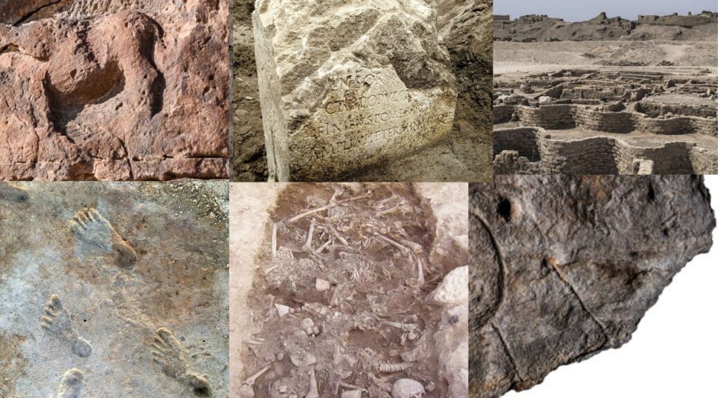
7. Rare Boundary Marker

A rare stone that once demarcated the boundary of ancient Rome’s sacred precinct was unearthed by workers renovating the city’s sewer system. The six-foot-tall limestone block was found embedded in the ground where it had been placed almost 2,000 years ago and is one of only 10 of its kind ever discovered. The marker, which is known as a cippus, was one of the dozens that were installed around the city to mark the pomerium, a hallowed zone where activities were dictated by a strict set of rules. For example, no one could be buried within its limits, and crossing the boundary bearing arms was forbidden. This symbolic barrier was the border between Rome proper—the urbs—and its outlying territory—the ager—and separated religious activities from civic and military life.
The pomerium was periodically expanded as Rome grew outward from its original core. Roman legend holds that Romulus, the city’s mythical founder, created the original pomerium in the eighth century B.C. around his fledgling settlement. An inscription on the newly discovered cippus indicates it was erected in A.D. 49 when the emperor Claudius (r. A.D. 41–54) significantly redrew the city’s limits.
6. Bronze Age Map

When a team of researchers led by Clément Nicolas, an archaeologist at Bournemouth University, first saw archival photographs of a broken schist slab held at France’s National Archaeology Museum, they were intrigued. Because the seven-by-five-foot slab was carved with repeated motifs linked by a network of lines, they suspected it might be some sort of map. The slab had been excavated in 1900 from a barrow in Brittany, where it formed one of the walls of a stone tomb dating to the end of the Early Bronze Age, from roughly 1900 to 1640 B.C. The artefact, which weighs more than a ton, had been in storage for over a century when Nicolas and his colleagues, including Yvan Pailler of the University of Western Brittany and France’s National Institute of Preventive Archaeological Research, retrieved it to take a closer look.
The archaeologists recognized that a triangular hollow at the slab’s left edge resembles the shape of the Odet River Valley near where it was discovered. A square motif in this hollow appears to represent a prominent granite mass in the landscape. Likewise, the lines on the slab closely match the area’s river network. Nicolas’ team concluded that the slab is a map of an area measuring some 19 miles by 13 miles and that it dates to approximately 2150 to 1600 B.C. “This is the oldest map of a territory that we can recognize in Europe,” says Nicolas. A motif in the centre of the slab may mark an enclosure, leading the researchers to suggest that the map depicts the realm of a small Bronze Age kingdom and that its purpose was to stake a claim to this territory.
5. Oldest Animal Art

Twelve panels depicting images of camels and wild donkeys are now known to be the oldest life-size animal reliefs in the world. By using techniques such as analyzing tool marks and erosion, as well as radiocarbon dating associated artefacts, researchers have dated the reliefs at what is known as the Camel Site to the middle of the sixth millennium B.C.—some 5,000 years earlier than they had originally thought. During the Neolithic period (ca. 8000–3000 B.C.), northern Arabia was much wetter than it is now, and nomads herded sheep, cattle, and goats and hunted abundant wildlife. Animals would have had a crucial role in the herders’ existence, which may help explain why they created the massive reliefs.
Archaeologist Maria Guagnin of the Max Planck Institute for the Science of Human History explains that the site was clearly used for centuries, and possibly even millennia and new reliefs were periodically added or old ones re-carved when details began to fade. “I wonder if the site was visited regularly, but reliefs were only added on special occasions,” she says. “Or was it only visited for special occasions, when new reliefs were added or existing ones repaired?” Guagnin has no question, however, regarding the mastery displayed by the Neolithic artists, who worked high atop cliffs where they would never have been able to see the entire animal while carving it. “The level of naturalism and detail is astonishing,” she says, “and the technical skill and community effort involved in the creation of these reliefs is evidence of the importance of rock art in the social and symbolic life of the Neolithic herders of northern Arabia.”
4. The First Americans

Over the past two decades, archaeologists have discovered a number of sites that show that people first arrived in the Americas as early as 16,000 years ago. Some scholars have explored sites that have yielded even earlier dates, but other researchers have questioned the legitimacy of these discoveries, arguing that artefacts recovered from them are not unambiguously the work of human hands. Now, radiocarbon dating of material associated with fossilized human footprints at White Sands National Park has shown that people were living in North America up to 23,000 years ago.
The prints are part of hundreds of fossilized human trackways archaeologists have found at the park that was left in what were once muddy surfaces surrounding an extinct lake. A team including Cornell University archaeologist Tommy Urban identified a series of such trackways, left mainly by teenagers and younger children, that were superimposed on top of each other over the course of millennia. Radiocarbon dating of aquatic plant seeds found below and above six of these trackways shows they were created between 23,000 and 21,000 years ago. “Scholars can question whether a stone or bone artefact was actually shaped by humans,” says Urban, “but there’s no mistaking who made a human footprint.”
3. Earliest Leatherworkers

While sorting through some 12,000 bone fragments excavated from Contrebandiers Cave near the Atlantic coast of Morocco, archaeologist Emily Hallett of the Max Planck Institute for the Science of Human History noticed that some were smooth and shiny, as if they had been intentionally shaped by human hands. Upon consultation with colleagues, she determined that 62 of the fragments are bone tools dating to between 120,000 and 90,000 years ago. These include a number of tools made from animal rib bones of a type well known for its use in fur and leatherworking. “Once you have an animal skin, there are a lot of steps that have to be taken to process it so it’s supple, smooth, and ready to wear,” says Hallett. “These tools remove the connective tissues and fats from the skin without piercing and damaging it.”
Amid the assemblage, Hallett also identified bones of carnivores such as sand foxes, golden jackals, and wildcats that had marks indicating they had been skinned for their hides or fur. Together, the carnivore bones and bone tools appear to provide the earliest known evidence of people making clothes. This fits well with previous genetic studies of clothing lice that suggested clothing was first worn by humans in Africa up to 170,000 years ago. Hallett says it’s also possible that people at Contrebandiers Cave produced leather to string small beads together to make symbolic personal ornaments. Pierced shells from the snail genus Nassarius dating to around the same time as the bones have also been found in the cave.
2. World’s First Artists

The world’s earliest rock art may have been made by two creative children who lived in Tibet between 226,000 and 169,000 years ago. The young artists, probably either Neanderthals or members of the related Denisovan species, left a series of closely grouped handprints and footprints on an outcrop of a type of limestone called travertine. Travertine, which builds up around mineral springs, is initially soft enough to hold impressions. These can eventually harden after the spring changes course. Other ancient prints have been found preserved in travertine near the hot spring where the children’s prints were discovered, says Guangzhou University geologist and environmental archaeologist David Zhang. “The local people associate them with the Buddha,” he says, “but they were puzzled by these prints because they are so small.”
Zhang and his colleagues used uranium-series dating, which examines trace amounts of uranium and thorium in calcium carbonate deposits such as travertine, to determine when the prints were left on the outcropping’s surface. Since uranium decays to thorium at a known rate, the researchers were able to calculate the age of the travertine from the ratio of the two elements. “I was shocked by the date,” says Zhang. “They are so early and there is no utilitarian explanation for how they are grouped together. They had to have been deliberately composed.” Zhang acknowledges that some might consider the prints childish doodles rather than true art. “What is play and what is art?” he asks. “We think these prints are both.”
1 Golden City

A settlement that was buried beneath the sand for thousands of years—and eluded archaeologists for centuries—is believed to be one of the largest ancient Egyptian cities ever unearthed. The site was discovered by a stroke of good luck when archaeologists began searching for the mortuary temple of the boy pharaoh Tutankhamun (r. ca. 1336–1327 B.C.) along the west bank of the Nile in Luxor. What they found instead was a well-preserved urban settlement filled with houses, streets, and walls, some of which still stand 10 feet tall. Hieroglyphic inscriptions indicate the city was called tehn Aten, or “dazzling” Aten, and that it was founded by Tutankhamun’s grandfather Amenhotep III (r. ca. 1390–1352 B.C.). “I call this the ‘Golden City’ because it dates to the reign of Amenhotep III, which was the golden age of ancient Egypt,” says project director Zahi Hawass.
Aten was Egypt’s main administrative and industrial center. The city’s remarkable state of preservation is providing researchers with an unprecedented view of life there more than 3,000 years ago. Although only about one-third of the site has been excavated thus far, archaeologists have uncovered houses containing everyday objects including ceramic vessels, children’s dolls, and limestone gaming pieces. They have also identified bakeries, kitchens, and other areas associated with food production, as well as a vessel containing more than 20 pounds of dried meat prepped by a butcher named Luwy. There are also workshops that produced mudbricks and decorative amulets, and a residential and administrative neighbourhood that was encircled by distinctive zigzag walls. Scholars do not yet understand why Aten fell into decline, but it may have been abandoned when Amenhotep III’s son, Akhenaten (r. ca. 1349–1336 B.C.), moved the Egyptian capital from Luxor to Amarna, 250 miles away.