A 6,000-year-old skull found in a cave in Taiwan possibly confirms the legend of an Indigenous tribe
A team of researchers with members from Australia, Japan, Taiwan and Vietnam found a 6,000-year-old skull and femur bones in a cave in a mountainous part of Taiwan that might prove the existence of an ancient Indigenous tribe.
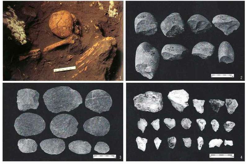
The preceramic human remains from No. 5 Cave (1) and representative stone tools from the preceramic layer, including the cobble chopping tools (2), flake tools (3), and fine-material lithic tools made of quartz (4) of Xiaoma (after Huang and Chen 1990).
In their paper published in the journal World Archaeology, the group describes the skull, where it was found and what it might represent.
In Taiwan, there have been stories passed down through the generations about a tribe of short, dark-skinned people that once lived in mountainous parts of the island. But until now, there has been no physical evidence of them.
In this new effort, the researchers found skull and leg bones in a cave that have been dated back to approximately 6,000 years ago—a time before the ancestors of people who are alive on the island arrived.
In studying DNA from the skull, the researchers found it close to African samples from around the same time period. But they also found that its size and shape resemble that of Negritos, who lived in parts of what is now South Africa and in the Philippines.
A study of bones left behind in those areas showed them to be quite short with small body size. Femur bones found near the skull were from the same person as the skull, a young woman.
The researchers estimate she stood approximately 1.3 meters tall.
The researchers suggest their findings confirm the existence of the ancient people in Taiwan but they do not explain what might have happened to them.
They were apparently gone by the time other early Austronesian groups of people began arriving.
The researchers also note that the mention of small, dark-skinned people was made in documents from the Quin Dynasty, and all but one of the 16 Austronesian groups living in Taiwan today have stories that describe small, dark-skinned people who once lived in the mountains.
Such tales differ, however, between groups, the researchers note, with some believing that the earlier people were ancestors of theirs. Others see them as former enemies.
One group claims to have killed off the last of the ancient people 1,000 years ago.
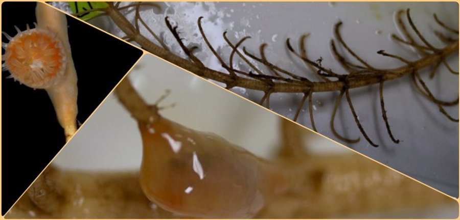
Species found to have existed since the Paleozoic era was found in the depths of the ocean near Japan. It has been understood that life forms that have lived on the ocean floor for millions of years existed much longer than human history, according to the fossil record, and that they managed to survive by living out of sight.
The discovery of 273-million-year-old ‘living fossils’ was made by the discovery of two sea creatures that were found to have symbiotic life between them, 100 meters below the sea surface, near Japan’s Honshu and Shikoku islands.
According to the fossil record, it was determined that the skeletons have not been changed at all.
The researchers completed their non-invasive research using a DNA barcode to identify the species.
The researchers, who discovered that these newly discovered specimens did not change the structure of the shellfish skeletons, said that this provides a possible clue as to why they have disappeared from the fossil record for so long.
They discovered that fossils of soft-structured organisms were so rare that they could be overlooked.
“These specimens represent the first detailed records and examinations of a recent in vivo relationship between a crinoid (host) and an epibiont,” the researchers said.
Crinoids and corals shared a long, symbiotic relationship millions of years ago; Here, corals used crinoids to climb higher than the seafloor, gaining access to more food found in ocean currents.
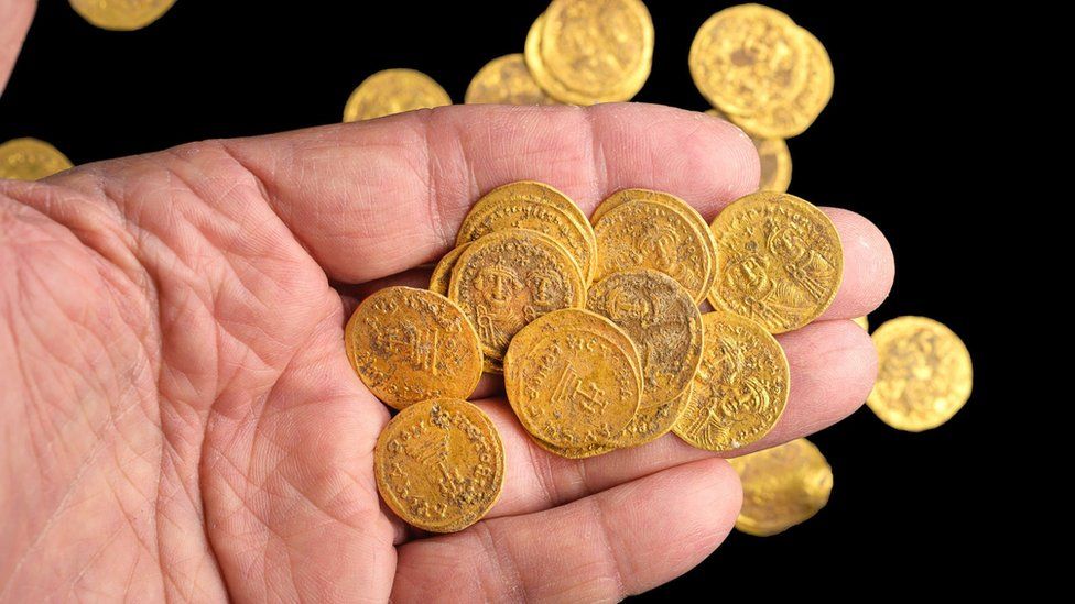
Byzantine gold coins hidden in a wall in the 7th century were uncovered by Israeli archaeologists
Archaeologists in Israel say 44 pure gold coins dating to the 7th Century have been found hidden in a wall at a nature reserve.
Weighing about 170g, the hoard found at the Hermon Stream (Banias) site was hidden during the Muslim conquest of the area in 635, experts estimated.
They said the coins shed light on the end of the Byzantine rule in the area.
The Byzantine Empire was the eastern half of the Roman Empire, which survived for more than 1,000 years.
“We can imagine the owner concealing his fortune in the threat of war, hoping to return one day to retrieve his property,” said Yoav Lerer, director of the excavation.
“In retrospect, we know that he was less fortunate.”
Dr Gabriela Bijovsky says the coins help document the life of Emperor Heraclius’s family
Apart from the gold coins, the excavation – in a residential quarter of the ancient city – also uncovered the remains of buildings, water channels and pipes, bronze coins and much more, Israeli authorities said.
Dr Gabriela Bijovsky, a numismatic (currency) expert at the Israel Antiquities Authority, said some of the coins were of Emperor Phocas (602-610), but most were of his successor Heraclius.
Banias has a particular place in Christian tradition, being the site where Jesus is said to have told the apostle Peter, “on this rock, I will build my church”.
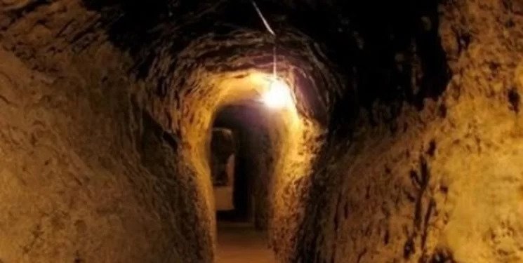
Medieval subterranean corridors were found by accident in northeast Iran
The workers working on a routine road construction project near Shahr-e Belqeys (City of Belqeys) in northeast Iran made an unexpected discovery.
Shahr-e Belqeys is a castle located in Esfarayen County in North Khorasan Province, Iran. The fortress dates back to the Sasanian Empire. It is the second largest adobe fort in Iran after the UNESCO-registered Bam Fortress. Belqeys archaeological site has an area of over 51,000 square.
“Remains of ancient underground corridors were discovered a few days ago during a road construction project in Bam village of Esfarayen county,” an expert with Belqeys archaeological site said on Monday.
“The total length of those corridors is 18 km, and there is a bathroom and a mill on the way, which has not been opened yet,” the expert said. “Last years, traces of this underground city had been discovered but to protect it, these remains were blocked by the local cultural heritage directorate.
Now we reached these ancient structures from another place, which confirms the statements of the local people,” the expert explained. “The ruins have yielded potteries estimated to belong to the Seljuk period, IlKhanid, and even earlier periods. However, an extensive archaeological excavation is needed to delve into its secrets.”
Belqeys Castle.
Shahr-e Belqeys was prosperous during a period from the late Sassanid era to early Islamic times. Historical evidence, including a book on the history of Nishabur (Middle Persian: Nev-Shapur), suggests that Shahr-e Belqeys won special attention from Sassanid monarchs of the time.
Archaeological excavations at nearby mounts and hilltops put the antiquity of Belqeys in some 6,000 years.
These Medieval subterranean corridors in Iran are not a first. Nooshabad, known as Ouyi to locals, is an underground city with many passages and chambers in Isfahan Province in central Iran.
Nushabad or Nooshabad Underground City.
Nooshabad, which was discovered by chance during a construction project, was initially built to protect city dwellers against invasion and plundering, particularly during the Mongol invasion of Iran.
The construction of this man-made subterranean city, called Ouee (or Ouyi), dates back to the Sasanian (or Neo-Persian) Empire that ruled from 224 to 651. Inhabitants would dig underground chambers as hideout spots for women, children, and the elderly in the event of an attack by foreign invaders.
The fact that these newly found underground tunnels were built in the same way reveals their intended use. In the future, it will be possible to have more information about the tunnels if the Iranian government allows the excavation works.
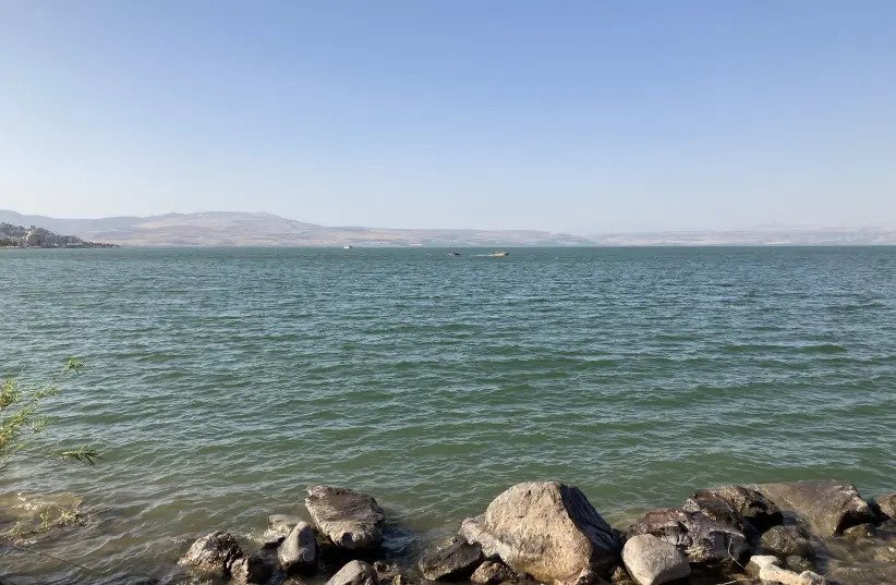
Ancient Islamic mosaics uncovered on the shores of Kinneret
Ancient mosaics belonging to an early Islamic settlement have been uncovered by archaeologists from a German university in the Kinneret.
A VIEW of the Kinneret with the Hermon in the background. The view that inspired Rachel the Poetess, among others.
The mosaics, found near Khirbat al-Minya, are believed to have acted as a contact point for Umar and local Arab tribes dating to the fifth century BCE.
Khirbat al-Minya may have also served as a caravanserai, known to some as a caravan inn. Travellers coming through the region at the time would be able to rest there and recharge before heading back on their long, often strenuous journey.
Archaeologists from Germany’s Johannes Gutenberg University Mainz (JGU) discovered these ancient mosaics along the Kinneret’s shoreline after geomagnetic surface surveys and subsequent excavations were done in the surrounding area.
According to JGU archaeologists, this discovery was made possible by the geomagnetic surface surveys themselves. Through this process, along with specifically-mapped “exploratory cuts,” archaeologists from the Mainz team were able to prove that the caliph, which was the title of the chief Muslim civil and religious ruler, strategically planned his palace. This residence was complete with a mosque and a high gate tower close to a nearby settlement.
At the time of construction of this palace, the shoreline was believed to have been almost completely deserted.
THE WONDERFULLY watery Kinneret, photo snapped while barefoot on the rocks.
Prof. Dr. Hans-Peter Kuhnen of JGU uncovered remarkable details from their discoveries. “Our most recent excavations show that Caliph Walid had his palace built on the shore of the Sea of Galilee in an already carefully structured landscape that had long been inhabited.”
“It was here that considerable money was subsequently made through the cultivation of sugar cane, sadly causing lasting damage to the ecosystem,” he said. What started generations ago as a money-maker would in turn have a cost that would never be repaid.
“Our research has brought this settlement adjacent to the caliph’s palace to light again, putting it in its rightful context among the history of human settlement of the Holy Land,” Kuhnen said. “Over the centuries, it experienced alternating periods of innovation and decline, but there was no real disruption to its existence during its lifetime.”
The Mainz archaeologists involved with the project found stone buildings from different periods made of basalt with plastered walls, a cistern and colored mosaic floors.
The tiles were found decorated with blossom designs, along with pictures of the animal and plant world of the Nile Valley.
The art found in the mosaics was believed to have symbolized “the life-giving power of the great river, which ensured Egypt’s fertility through the annual Nile flood.”
What can we learn from this discovery?
Archaeologists from JGU are confident this discovery shows that though life in Israel may have gone through major changes throughout the years, it never really made a full stop, which allows it to thrive today.
“With this research, we give the settlement in front of the threshold of the caliph’s palace a place on the stage of the settlement history of the Holy Land, which over the centuries has experienced a change of innovation and decline, but never real breaks,” a JGU representative said.
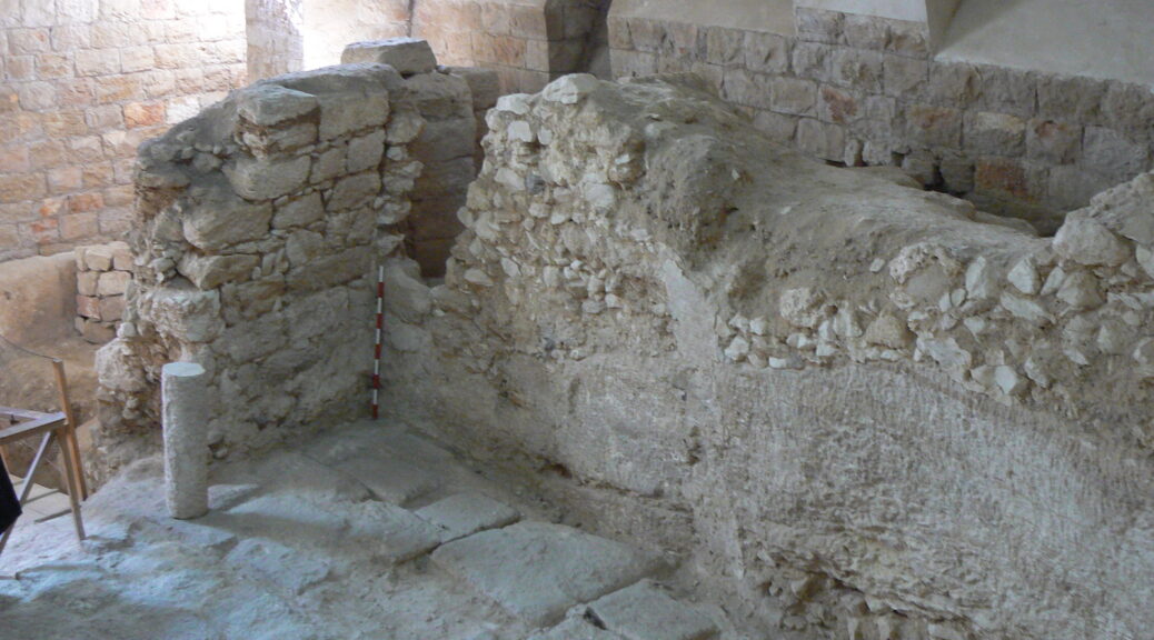
The story begins with a dig by non-archaeologists: nuns who, in 1881, happened upon an ancient cistern while building the Sisters of Nazareth convent, but didn’t know what they had stumbled upon. Dark describes it as “one of the first examples of an archaeological project directed by a woman.”
“In many ways, they were way ahead of their time,” Dark told Artnet News. “They conducted a perfectly reasonable rescue excavation or salvage excavation.”
Records from their exploration, as well as another, by a Jesuit priest in the mid-20th century, were key to Dark’s research. The site had otherwise long languished, ignored by scholars, he said.
The location was home to several structures and uses over two millennia, Dark said, all of which are essential for his conclusion.
First, there was a 1st-century building, partly cut out of rock, that may have been a dwelling. The site was then used as a quarry, and then for a tomb. Later, it was home to a cave church, possibly one mentioned by the pilgrim Egeria, who wrote an account of her travels to the Holy Land in about AD 380.
Later, a Byzantine church was built on the ground above. Dark suspects it may be the previously lost Church of the Nutrition, which was built to commemorate the place where Christ was raised and was mentioned by Irish abbott and historian Adomnán in his book De Locis Sanctis (Concerning Sacred Places) in the late 7th century.
The 1st-century house at the Sisters of Nazareth site.
The church burned down around the year 1200 and was not in religious use until the Sisters of Nazareth began to build their convent there in the 1880s.
“The Byzantine church Sisters of Nazareth seems as though it was almost certainly the building described by Adomnán,” Dark said. “It was very large, very elaborately decorated, and probably from the 5th century.
“It overlay a crypt, which is also described in his book. In the crypt, just as he says, there are two Roman-period tombs, and between them, there’s a house—and that house, Adomnán says, is the place where Jesus was brought up.
“So, we found the church, we found the crypt, we found the house.”
Is it a slam dunk? Dark is quick to say no. But, he said, people historically much closer to Jesus felt it was: “I can be confident that it’s the house that the Byzantines believed, and was probably believed in the 4th century, to be Jesus’s childhood home.”
Dark was hardly out to uncover what he may have found.
“Primarily, I was there to look at the emergence of the Byzantine pilgrimage centre of Nazareth,” he said. “To have found the Sisters of Nazareth in itself seemed to be an amazing discovery.”
He hardly expected to find a 1st-century house, and possibly such an interesting one, underneath.
Evidence of Opium Use by Canaanites in 14th Century BC Found
A new study by the Israel Antiquities Authority, Tel Aviv University, and The Weizmann Institute of Science has revealed the earliest known evidence of the use of the hallucinogenic drug opium, and psychoactive drugs in general, in the world.
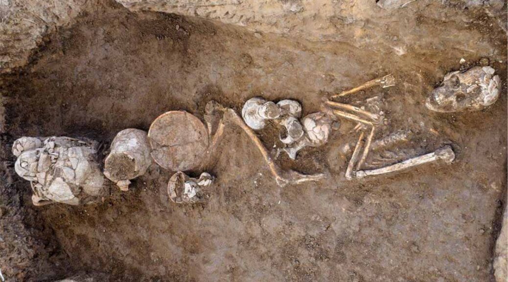
The opium residue was found in ceramic vessels discovered at Tel Yehud, in an excavation conducted by Eriola Jakoel on behalf of the Antiquities Authority.
The vessels that contained the opium date back to the 14th century BC, and they were found in Canaanite graves, apparently having been used in local burial rituals. This exciting discovery confirms historical writings and archaeological hypotheses according to which opium and its trade played a central role in the cultures of the Near East.
One of the 14th-century-BC Canaanite burials at Tel Yehud was associated with vessels containing traces of opium.
The research was conducted as part of Vanessa Linares’s doctoral thesis, under the guidance of Professor Oded Lipschits and Professor Yuval Gadot of Tel Aviv University’s Department of Archeology and Professor Ronny Neumann of the Weizmann Institute, in collaboration with Eriola Jakoel and Dr. Ron Be’eri of the Israel Antiquities Authority, and the study was published in the journal Archaeometry.
In 2012, the Antiquities Authority conducted a salvage excavation at the Tel Yehud site, prior to the construction of residences there.
A number of Canaanite graves from the Late Bronze Age were found in the excavation, and next to them were burial offerings—vessels intended to accompany the dead into the afterlife. Among the pottery, a large group of vessels made in Cyprus and referred to in the study as “Base-Ring juglets,” stood out.
Because the vessels are similar in shape to the poppy flower when it is closed and upside down, the hypothesis arose already in the 19th century that they were used as ritual vessels for the drug. Now, an organic residue analysis has revealed opium residue in eight vessels, some local and some made in Cyprus. This is the first time that opium has been found in pottery in general, and in Base-Ring vessels in particular. It is also the earliest known evidence of the use of hallucinogens in the world.
Be’eri of the Israel Antiquities Authority says, “In the excavations conducted at Tel Yehud to date, hundreds of Canaanite graves from the 18th to the 13th centuries BC have been unearthed. Most of the bodies buried were those of adults, of both sexes.
The pottery vessels had been placed within the graves were used for ceremonial meals, rites and rituals performed by the living for their deceased family members.
The dead were honoured with foods and drinks that were either placed in the vessels, or consumed during a feast that took place over the grave, at which the deceased was considered a participant. It may be that during these ceremonies, conducted by family members or by a priest on their behalf, participants attempted to raise the spirits of their dead relatives in order to express a request, and would enter an ecstatic state by using opium. Alternatively, it is possible that the opium, which was placed next to the body, was intended to help the person’s spirit rise from the grave in preparation for the meeting with their relatives in the next life.”
Linares of Tel Aviv University explains: “This is the only psychoactive drug that has been found in the Levant in the Late Bronze Age. In 2020, researchers discovered cannabis residue on an altar in Tel Arad, but this dated back the Iron Age, hundreds of years after the opium in Tel Yehud.
Because the opium was found at a burial site, it offers us a rare glimpse into the burial customs of the ancient world. Of course, we do not know what the opium’s role was in the ceremony—whether the Canaanites in Yehud believed that the dead would need opium in the afterlife, or whether it was the priests who consumed the drug for the purposes of the ceremony. Moreover, the discovery sheds light on the opium trade in general.
One must remember that opium is produced from poppies, which grew in Asia Minor—that is, in the territory of current-day Turkey—whereas the pottery in which we identified the opium were made in Cyprus. In other words, the opium was brought to Yehud from Turkey, through Cyprus; this of course indicates the importance that was attributed to the drug.”
Be’eri adds, “Until now, no written sources have been discovered that describe the exact use of narcotics in burial ceremonies, so we can only speculate what was done with opium. From documents that were discovered in the Ancient Near East, it appears that the Canaanites attached great importance to ‘satisfying the needs of the dead’ through ritual ceremonies performed for them by the living, and believed that in return, the spirits would ensure the health and safety of their living relatives.”
According to Eli Eskosido, director of the Israel Antiquities Authority, “New scientific capabilities have opened a window for us to fascinating information and have provided us with answers to questions that we never would have dreamed of finding in the past. One can only imagine what other information we will be able to extract from the underground discoveries that will emerge in the future.”
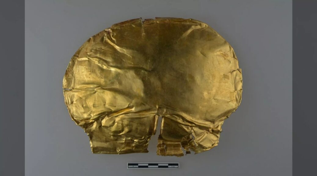
Gold Mask Found in Shang Dynasty Tomb in Central China
A gold funeral mask, thought to be more than 3,000 years old, has been discovered in the tomb of an ancient noble in the city of Zhengzhou in central China.
The gold funeral mask was found in the tomb of an ancient noble of the Shang Dynasty. It is thought to be more than 3,000 years old.
It’s one of the oldest gold objects ever found in central China, as contemporary treasures tend to be crafted from bronze and jade, raising questions about possible links to other early Chinese states where gold was more common.
The gold mask is 7.2 inches (18.3 centimetres) long and 5.7 inches (14.5 cm) wide — large enough to cover the entire face of an adult, Huang Fucheng, a researcher at the Zhengzhou Municipal Institute of Cultural Heritage and Archaeology, told the state-owned China News Service(opens in new tab). It weighs about 1.4 ounces (40 grams).
And the South China Morning Post(opens in new tab) (SCMP) reported that the institute’s director, Gu Wanfa, said the gold mask may have symbolized that the deceased had an “imperishable gold body” and was likely intended to keep the spirit of the dead person whole.
Government archaeologists made the announcement of the mask’s discovery during a news conference in Beijing on Sept. 16. Finds from three other ancient Chinese archaeological sites were also revealed at the news conference, but the gold mask is arguably the most striking.
The newfound noble’s tomb dates to the Shang Dynasty, which ruled in the Yellow River valley from about 1600 B.C. to 1046 B.C. — the earliest dynasty ever recorded in China, Live Science previously reported.
The tomb, which covers an area of more than 108,000 square feet (10,000 square meters), contains more than 200 other artefacts, China News Service reported(opens in new tab), including ornate objects of bronze and jade, such as daggers, axes, wine vessels, smoking pipes and goblets. Archaeologists also found plaques inlaid with turquoise and coins made from shells.
Ancient gold
The newfound Zhengzhou tomb is a significant find for research into the burial rituals of the Shang Dynasty, and it may even provide new insight into the origins of Chinese civilization, Chen Lüsheng, deputy director of the National Museum of China in Beijing, told the outlet.
The newly discovered funeral mask, from the tomb at Zhengzhou in Henan province, is older than the gold funeral mask found last year in the Sanxingdui Ruins, an archaeological site in China’s southwestern Sichuan province attributed to the Shu kingdom.
The Shu kingdom in the southwest is traditionally dated as later than the Shang Dynasty in central China. But the two states may have existed at the same time, and archaeologists hope to establish links between them.
The Sanxingdui mask had detailed facial features, but archaeologists said it was attached to a wooden post or mannequin, rather than to an actual dead body. Such masks and other gold artefacts are relatively common at the Sanxingdui Ruins site, but they are rare at Shang Dynasty sites.
However, it’s unclear whether the younger Sanxingdui mask and the newfound Shang mask have any connection. “Although this gold mask is older than those unearthed from the Sanxingdui Ruins, we still need more evidence and a larger [number] of archaeological discoveries to confirm a direct connection between the Shang city ruins and the Sanxingdui Ruins,” Chen said.
Early China
The discovery of the new gold mask is “exciting,” said archaeologist and metallurgist Ruiliang Liu, a curator of the Early China Collection at the British Museum in London who wasn’t involved in the Zhengzhou finds.
Liu told Live Science that the ritual system of Bronze Age China was dominated by ritual vessels of jade and bronze — a tradition that was established during the Shang Dynasty when an extensive industry existed to manufacture such objects.
Gold and silver, however, were associated with the pastoralist cultures of the steppes, such as those of Central Asia, northwestern China and Mongolia, he said.
“The discovery of the gold mask in such an early and important context at Zhengzhou raises many intriguing questions,” Liu said. “Where does the raw gold come from? … [and] why did the tomb occupant choose to be buried with gold, while other top elites chose only bronzes and jades?”
One possibility is that the gold had been found in relatively small amounts at Panlongcheng — an important Shang site near the modern city of Wuhan that supplied copper, and tin and probably lead to ancient Zhengzhou — and that it had been worked by local artisans with the techniques they used for other metals, he said.
But another possibility is that the gold was brought from farther afield as an exotic metal, which could indicate a trade network existed during the Shang period between the Yellow River valley and gold-producing regions, such as the Yangtze River valley farther south, he said.
Liu also noted that very few Shang Dynasty archaeological sites near Zhengzhou have been excavated because a large modern city sits above most of them.
“The major part of Zhengzhou archaeology is under the modern Zhengzhou city,” Liu said. “I am sure more will come to light in the future.”