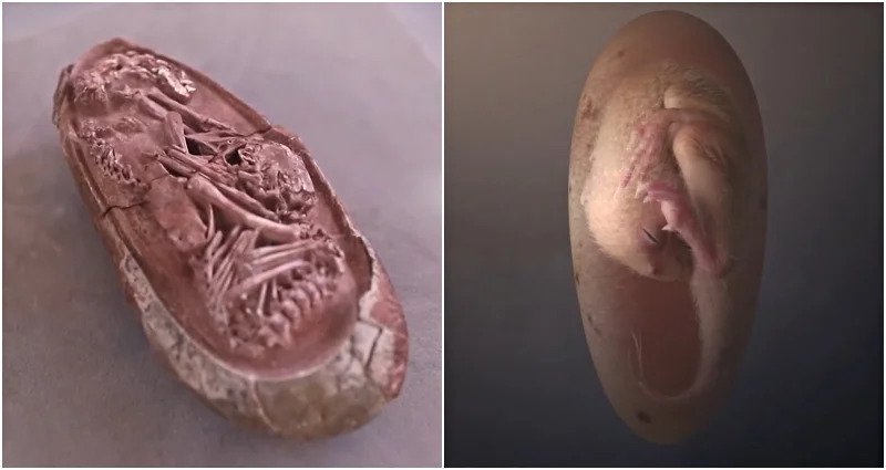
Category Archives: ASIA

The Mysterious 1,300-Year-Old Siberian Lake Fortress

The Mysterious 1,300-Year-Old Siberian Lake Fortress

It is one of the most mysterious archaeological sites in Russia – an ancient complex engulfing a small island in the centre of a remote lake in the mountains of southern Siberia. At first glance, it appears to be an ancient fortress, its perimeter of high walls constructed to keep out enemies.

However, others have proposed the 1,300-year-old structure may have been a summer palace, monastery, memorial complex, ritual centre, or astronomical observatory.

According to the Siberian Times, more than a century after its rediscovery, experts are no closer to understanding the secrets of these enigmatic ruins.

The Mysterious 1,300-Year-Old Siberian Lake Fortress

The archaeological site is known as Por Bajin (also spelt Por-Bazhyn), meaning ‘clay house’. It is located on an island in the middle of Tere-Khol Lake in Tuva, Siberia, just 20 miles (32 km) from the Mongolian border. 

First explored in 1891, the site was not excavated until 1957-1963. However, it was not until 2007-2008 that the first large-scale research was undertaken, carried out by the Por Bajin Cultural Foundation.

What they discovered presented a conundrum – the structure is located in a very remote place on the outskirts of what was the Uighur nomad empire, built with Chinese features, but with no sign of permanent habitation, and abandoned after only a short period of use.

Why was it built? How was it used? And why was it abandoned? These are the questions that have continued to both fascinate and frustrate experts ever since its discovery.

Inside the complex of Por Bajin.

The Construction of Por Bajin

Believed to have been constructed in 757 AD, the ancient complex has outer walls that still rise to 40 feet (12 meters) in height and inner walls of 3-5 feet (1 – 1.5 meters), some still covered with lime plaster painted with horizontal red stripes. The main gate was discovered, opening into two successive courtyards connected by another gate.

The walls enclose an area of about seven acres containing the remains of more than 30 buildings, but with a two-part central structure linked by a covered walkway, which once had a tiled roof and was supported by 36 wooden columns resting on stone bases.

Laser mapping of the site prior to the first major excavation in 2007 helped experts build a 3D model of what the complex might have looked like.

Por-Bajin reconstruction seen from the east.

Only a small number of artefacts were ever recovered from the site – if it had been permanently inhabited one would expect to find a much greater number of items.  There was also no evidence of any kind of heating system, which would have made it impossible to stay there, at 2,300 meters above sea level, in winter conditions.

The main finds include clay tablets of human feet, faded coloured drawings, fragments of burnt wood, roof tiles, an iron dagger, a stone chalice, one silver earring, and iron construction nails. None of the artefacts provides a definitive answer as to why the structure was built, and how it was used.

One of the tiles was found at Por Bajin.

Since the end of the 19th century, Por-Bajin has been linked to the Uighur Khaganate nomadic empire (744 – 840 AD), composed of nomadic Turkic-speaking people held together by forces of warriors on horseback. The empire spanned Mongolia and southern Siberia, however, the location of Por Bajin was still well away from settlements and trade routes.

Why would they build in such a remote location? Could it have been the site of a palace or a memorial for a ruler? The unique layout, more ornate than that of other Uighur fortresses of the period, has led some scholars to suggest that it might have had a ritual role.

Still, there are some other puzzling features. The architecture reflects a distinctive Chinese style, as evidenced by the use of Chinese building materials, such as certain types of roof tiles, and the use of Chinese construction methods.

The layout, with its axial planning, dominant central building, and residential quarters is consistent with styles seen in other Buddhist monasteries. But Por-Bajin shows no evidence of religious practice.

Small yards (left) running along Por-Bajin’s walls each had a building in the centre. A digital reconstruction (right) based on excavations shows that each building could have functioned as a dwelling, perhaps for monks if the site were a monastery.

Why was it abandoned?

Not only has Por Bajin presented a mystery regarding its purpose, but archaeological evidence suggests it was abandoned after only a short period of use.

No evidence has been found to suggest the complex came under attack from an opposing force. Political changes in the region may offer one possible explanation, although nothing concrete has been presented to support this theory. 

According to Dmitriy Subetto, from the Department of Physical Geography RGPU, the structure may have been abandoned prior to completion due to the builders’ lack of familiarity with the permafrost.

For now, Por Bajin remains one of Russia’s enduring mysteries.

The Mysterious Man-Made Caves Of Longyou: 10 Unanswered Questions

The Mysterious Man-Made Caves Of Longyou: 10 Unanswered Questions

Located near the village of Shiyan Beicun in Zhejiang province, China lies the Longyou caves – an extensive, magnificent and rare ancient underground world considered in China as ‘the ninth wonder of the ancient world’. 

The Longyou grottoes, which are thought to date back at least 2,000 years, represent one of the largest underground excavations of ancient times and are an enduring mystery that has perplexed experts from every discipline that has examined them.  Scientists from around the world in the fields of archaeology, architecture, engineering, and geology have absolutely no idea how they were built, by whom, and why. First discovered in 1992 by a local villager, 36 grottoes have now been discovered covering a massive 30,000 square metres. Carved into solid siltstone, each grotto descends around 30 metres underground and contains stone rooms, bridges, gutters and pools.

The Mysterious Man-Made Caves Of Longyou: 10 Unanswered Questions

There are pillars evenly distributed throughout the caves which are supporting the ceiling, and the walls, ceiling and stone columns are uniformly decorated with chisel marks in a series of parallel lines. Only one of the caves has been opened for tourism, chosen because of the stone carvings found inside which depict a horse, fish and bird.  The Longyou caves truly are an enigma and here we will explore ten mysteries that are still unexplained despite more than two decades of research.

1. How were they constructed?

A rough estimation of the workload involved in building these five caves is awe-inspiring. The quantity of rock that would have been removed in the overall excavation of the grottoes is estimated to be nearly 1,000,000 cubic meters. Taking into account the average digging rate per day per person, scientists have calculated that it would take 1,000 people working day and night for six years to complete. These calculations are based purely on hard labour, but what they haven’t taken into account is the incredible care and precision of the sculptors, meaning that the actual workload would far surpass the theoretical estimation.  As for how they were constructed and what tools were used, it is still unknown. No tools have been found in the area, and, as we will explore later, scientists still don’t know how they achieved such symmetry, precision, and similarity between the different caves.

2. No traces of construction

Despite their size and the effort involved in creating them, so far no trace of their construction or even their existence has been located in the historic record. Although the overall excavation involved almost a million cubic metres of stone, there is no archaeological evidence revealing where that quantity of stone went, and no evidence of the work. Moreover, there is not a single historic document that refers to them, which is highly unusual considering the sheer scale of the project.  Their origin is a complete and utter mystery. 

3. Why were the walls chiselled?

Every single one of the caves is covered, from floor to ceiling, in parallel lines that have been chiselled into virtually every surface.

The effect is a uniform pattern throughout the caves, which would have required immense manpower and endless hours to create. The question is why? Was such labour-intensive work purely for decoration? 

Are the lines or patterns symbolic in some way? All that is currently known is that the markings are similar to those found on pottery housed in a nearby museum, which is dated between 500 and 800 BC.

4. Lack of fish

When the caves were first discovered, they were filled with water, which presumably had been there for a long period of time.  They had to be pumped out in order to realise that these were not just like the other ‘bottomless ponds’ found within the area, but man-made structures.  Most villages in southern China contain very deep ponds, which have been called “bottomless ponds” by generations of villagers. These ponds teem with fish, which are easily caught. However, after the first cave was pumped dry, not a single fish was to be seen, or any other sign of life.

5. How did the caves remain so well preserved?

One of the most interesting and challenging questions is how the caves have been able to keep their structural integrity for more than 2000 years. There are no signs of collapse, no piles of rubble, and no damage despite the fact that in some areas the walls are only 50 centimetres thick.  Over the centuries, the area has gone through numerous floods, calamities and wars, the mountains have changed their appearance and exposed stones have been weathered, but inside the caves, the form, patterns and markings are still clear and precise – it is as though they were built yesterday.

6. How did the builders work in the dark?

Due to the great depths of the caves, some areas at the bottom, which are not exposed to the opening above, are pitch-black. Yet even those dark areas are decorated with thousands of parallel lines on the walls, columns, and ceiling.  So how did the ancient people work in the dark?  

According to Jia Gang, a Tongji University professor specializing in civil engineering:

“There should be lamps, because the cave’s mouth is very small, and the sunbeam could only shine in the cave at a certain angle during a certain period of time. As one goes deeper into the cave, the light becomes dimmer. At the cave’s bottom, which is usually dozen of meters from the mouth, one could hardly see anything.”

However, this was at least two millennia ago and nothing that could have been used for lighting has been found.

7. Were the caves meant to be connected?

All of the 36 grottoes are distributed across an area of only one square kilometre. Considering such a high density, one cannot help asking whether some grottoes were meant to be connected. What would be the purpose of making so many separate caves in such a tight area without connecting them?

In many areas, the walls between the caves are very thin, only 50 centimetres, but they were never linked so it appears they were intentionally kept apart.  What’s more, many of the caves are almost identical to each other.

8. Who built them?

Nobody has any idea who built the caves. Some scientists have claimed that it was not possible or logical for such as mammoth job to have been undertaken by regular village people.

Only the emperor and the leaders could have organised such a huge project, like the construction of the Great Wall, which was built to defend against invasion from the outside. But if it was commissioned by an Emperor, why are there no historical records of its construction?

9. How did they achieve such precision?

The scale of the Longyou Grottoes is magnificent and momentous, the design was delicate and scientific, the construction was sophisticated, and the precision is indicative of superior craftsmanship. The model, pattern and style of each cave are extremely similar.  Every grotto is like a grand hall. One side is steep and another side is 45% inclined. The four walls are straight; the edges and corners are clearly demarcated. The chiselling marks are uniform and precise. According to Yang Hongxun, an expert at the Archaeological Institute of the Chinese Academy of Social Sciences,

“At the bottom of each cave, the ancient [builders] wouldn’t be able to see what the others were doing in the next grotto. But the inside of each cave had to be parallel with that of the other, or else the wall would be holed through. Thus the measuring apparatus should have been very advanced. There must have been some layout about the sizes, locations, and the distances between the caves beforehand.”

With the help of modern equipment and methods, the investigators measured the sizes of the walls and surprisingly found that the overall construction is extremely accurate. The walls between the caves are of the same thickness in different sections. So how did they achieve this precision? What were their methods?

10. What were they used for?

Following extensive investigations and study, scientists and scholars have attempted to put forward explanations for the grottoes, but none so far provide a convincing explanation for why they were built and what they were used for. Some archaeologists have suggested that the grottoes were the tombs of old emperors, emperor halls, or places for storage. But this interpretation is far-fetched. No funeral objects or tombs have been found and no artefacts left behind. If it were used like an emperor’s palace, the grottoes would have been designed differently with separate rooms for different purposes like entertaining, meeting, and sleeping, but no evidence can be found of this and no traces of habitation have been found.

Another hypothesis is that it was used for mining and extracting some type of mineral resource. However, mining operations would have required equipment and apparatus to extract the rocks and transport them. Again, no traces of this have been found, nor any evidence of where the rocks were taken. And of course, if the caves were just for mining, why create such intricate decorations on the walls, columns and ceilings?

Finally, some have suggested that the grottoes were the places for troops to be stationed and that an emperor of the past wanted to keep his soldiers out of view in order to keep his war preparations secret.  However, these caves could not have been built in a short period of time. They would have taken many, many years to build so it is unlikely to have been done in preparation for war, which tends to come about much more quickly. Furthermore, there are no signs of people having stayed in the caves. Despite decades of research, very few answers have emerged to explain the enigma of the Longyou caves. Our ancient ancestors have achieved many wondrous things, but this truly is an unexplained mystery.

An ancient fortress found by archaeologists may be a lost royal city

An ancient fortress found by archaeologists may be a lost royal city

A 2,000-year-old fortress built on a mountainside in what’s now Iraqi Kurdistan could be part of a lost royal city called Natounia. With the help of drone photography, archaeologists excavated and catalogued the site during a series of digs between 2009 and 2022.

An ancient fortress found by archaeologists may be a lost royal city
Researchers excavate the perimeter wall at the entrance to Rabana Valley in Iraqi Kurdistan.

Situated in the Zagros Mountains, the stone fortress of Rabana-Merquly comprises fortifications nearly 2.5 miles (4 kilometres) long, two smaller settlements, carved rock reliefs and a religious complex.

The fortress was on the border of Adiabene, a minor kingdom governed by the kings of a local dynasty. These rulers would have paid tribute to the neighbouring Parthian Empire, which extended over parts of Iran and Mesopotamia approximately 2,000 years ago, according to research led by Michael Brown, a researcher at the Institute of Prehistory, Protohistory and Near-Eastern Archaeology of Heidelberg University in Germany, with the help of Iraqi colleagues.

Carvings at the entrance to the fortress depict a king of Adiabene, based on the dress of the figure, in particular his hat, Brown said.

The carving resembles other likenesses of Adiabene kings, particularly one found 143 miles (230 kilometres) away at the site of an ancient city called Hatra.

Upper fortifications at the 2,000-year-old site are shown.

While it’s a matter of speculation, Brown believes the fort was the royal city known as Natounia, or alternatively Natounissarokerta, that was part of the kingdom of Adiabene.

“Natounia is only really known from its rare coins, there are (not) any detailed historical references,” Brown said via email.

Details deduced from seven coins describe a city named after a king called Natounissar and a location on the Lower Zab River, known in ancient times as the Kapros River.

“The location near to (but admittedly not on) the Lower Zab/ancient Kapros river, short occupation, and royal imagery all link the archaeological site to the description we can deduce from coinage.

There are also some unusual high-status tombs nearby,” Brown said.
“It’s a circumstantial argument. … Rabana-Merquly is not the only possibility for Natounia, but arguably the best candidate by far (for) the ‘lost’ city, which has to be in the region somewhere.”

The king in the carving could be the founder of Natounia, either Natounissar or a direct descendant.

The carving depicts a figure with an unusual hat and is thought to depict a king of Adiabene, said lead researcher Michael Brown of the University of Heidelberg.

The place name Natounissarokerta is composed of the royal name Natounissar, the founder of the Adiabene royal dynasty, and the Parthian word for moat or fortification, the study also said.

“This description could apply to Rabana-Merquly,” Brown said. As a major settlement positioned at the intersection between highland and lowland zones, it’s likely that Rabana-Merquly may have been used, among other things, to trade with pastoral tribes, maintain diplomatic ties, or exert military pressure.

“The considerable effort that must have gone into planning, building and maintaining a fortress of this size points to governmental activities,” Brown said.

The study said the discovery adds to our knowledge of Parthian archaeology and history, which remains markedly incomplete, despite its evident significance as a significant power in the ancient Near East.

The journal Antiquity published the research on Tuesday.

A perfectly preserved 700-year-old mummy in brown liquid looked only a few months old

A perfectly preserved 700-year-old mummy in brown liquid looked only a few months old

The skin of a mummy discovered by accident had been perfectly preserved for over 700 years. Road workers stumbled upon a jaw-dropping corpse belonging to a high-ranking woman from China’s Ming Dynasty.

A perfectly preserved 700-year-old mummy in brown liquid looked only a few months old
An extremely well-preserved female corpse was found on March 1, 2011

News of the remarkable archaeological breakthrough on in the city of Taizhou, in eastern China on March 1 2011 was first broken to the world’s press a decade ago.

A team expanding a street in the Jiangsu Province dug up by chance two wooden tombs believed to date back to China’s ruling power between 1368 and 1644.

Just six-and-a-half feet below the road surface was the woman whose features shoes and ring all remained intact and showed hardly any signs of deterioration.

A ring survived 700 years on the woman’s finger

Chinese archaeologists were immediately called from the nearby Museum of Taizhou to inspect the body and were stunned by the condition of almost everything from the woman’s skin and hair right down to her eyelashes.

Experts claimed it was as though the diminutive 4’9 woman found swamped in a mysterious brown liquid, had only died recently.

Taizhou was reportedly buzzing off the discovery which included a ring still fixed on a finger belonging to the long-dead woman.

Researchers said what she was clothed in on her death married up with the traditional costume of the Ming dynasty, as did various ceramics, ancient writings and other relics inside her coffin.

The coffin contained a mysterious brown liquid

Oddly bones which did not belong to the corpse were also buried with her.

It was the first discovery of a mummy in the region in three years and the sixth since 1979.

Previous findings sparked an interest in learning how corpses remained so well preserved from the Ming Dynasty and what rituals were involved in the mummification process.

Director of the Museum of Taizhou, Wang Weiyin, explained mummy tended to be clad in silk and a little cotton but both are difficult to keep in a good condition.

Excavations found that achieving such brilliant corpse preservation required technology used exclusively at very high-profile funerals.

Archaeologists from the Museum of Taizhou responded to the accidental discovery

5,200-year-old stone carving chrysalis found in north China

5,200-year-old stone carving chrysalis found in north China

According to the provincial archaeological research institute, archaeologists discovered a stone-carved silkworm chrysalis dating back at least 5,200 years in north China’s Shanxi Province last month.

5,200-year-old stone carving chrysalis found in north China

The stone-carved chrysalis was discovered in a semi-crypt house at the Shangguo Site in Wenxi County, near the city of Yuncheng. It measures 2.8 cm long, with a maximum abdominal diameter of 1.2 cm.

Archaeologists surmised that this home dates to the early stage of the late Yangshao Culture era, some 5,200 years ago, based on pottery fragments that have been discovered.

The Yangshao culture was a Neolithic culture that existed extensively along the middle reaches of the Yellow River in China from around 5000 BC to 3000 BC.

This culture is famous for its red-painted pottery, one of the two main types produced in the neolithic period in China, and before 2000 BC Yangshao was making spiral red earthenware pots fired in ovens at 1000°C-1500°C.

A model of Jiangzhai, a Yangshao village.

Yangshao artisans created fine white, red, and black painted pottery with human facial, animal, and geometric designs, and they did not use pottery wheels in pottery-making.

China News Service, Taiyuan, July 16 (Yang Peipei and Hu Jian) ​​The Wenxi Shangguo site in Shanxi released the latest archaeological results on the 16th. The site unearthed the Yangshao period and pottery models in the early Spring and Autumn Period.

The excavation further confirmed that the Shangguo site has two main periods, namely the middle and late Yangshao period and the late Western Zhou period to the Spring and Autumn period.

The excavation site in 2022 is selected to be adjacent to the west and north of the exploration in 2021. The excavation covers an area of ​​500 square meters.

Various relics have been found, including 2 ash ditch, 56 ash pits (including 7 house sites in the Yangshao era), 2 stove sites, 1044 pottery models, 183 pottery ware, 14 jade ware, 157 stone tools, 123 bone tools, 4 small copperware, 7 copper slag, 46 shellfish, 2 ironware, 4 egg shells, and 1 fruit stone unearthed. 1585 pieces.

Large water vessel of the late Yangshao culture; from Shaanxi, Shanxi or Gansu province; 4th millennium BC; Rietberg Museum (Zürich, Switzerland)

Among them, H50 is bag-shaped. Judging from the pottery pieces such as the red pottery and sand pots with piled patterns on the outside of the unearthed mouth, the white-robed pottery bowls, and the basket-shaped pointed bottom bottle belly pieces, they belong to the early stage of the late Yangshao period, about 5,200 years ago.

The pit is divided into four layers, and a stone-carved silkworm chrysalis was unearthed in the first layer.

Over the past 100 years, relics related to the silkworm culture have been unearthed in many places in Yuncheng City, said Tian Jianwen, a researcher with the provincial archaeology research institute.

“At present, many silkworm cocoons and chrysalises discovered in Yuncheng City have been found in good condition, indicating that the ancestors of Yangshao Culture in southern Shanxi had raised silkworms,” said Tian. The discovery of stone carving chrysalises provided important clues for the study of the origin and spread of silk, according to Tian.

The Eighth Wonder of the World: Sigiriya “The Lion Rock”

The Eighth Wonder of the World: Sigiriya “The Lion Rock”

The Sigiriya Rock Fortress, or the palace in the sky, is a masterpiece of ancient Sri Lankan ingenuity. The monolithic rock of Sigiriya is one of the most valuable historical monuments of Sri Lanka and the locals refer to it as the Eighth Wonder of the World.

Sigiriya, Sri Lanka. Author: Bernard Gagnon CC BY 3.0

This ancient rock fortress is located in the central Matale District between the towns of Dambulla and Habarane in the Central Province of Sri Lanka. Sigiriya, also known as the “Lion Rock”, is 200 meters (660 ft) higher than the surrounding jungles and a popular tourist attraction of the spectacular beauty in Sri Lanka.

Sigiriya.

As one of the eight World Heritage Sites of Sri Lanka, it has also been declared by UNESCO as the Eighth Wonder of the World.

This ancient rock fortress and palace ruin is surrounded by the remains of an extensive network of gardens and reservoirs. The gardens of Sigiriya are among the oldest landscaped gardens in the world.

The gardens of Sigiriya, as seen from the summit of the Sigiriya rock.

The name “Lion Rock” comes from the enormous lion which greets visitors halfway up the rock on a small plateau. In 476 CE, King Dhatusena ruled over Sri Lanka and next in line was his son Moggallana, but Moggallana’s brother named Kashyapa, had other plans.

The Lion Gate and Climbing Stretch.

Kashyapa schemed with the commander of the army to overthrow King Dhatusena. He usurped the throne from his father by force and imprisoned him to die slowly and painfully. Kashyapa drove his brother Moggallana into exile in Southern India and he crowned himself king in 477 CE.

Close up of the Lion’s Paw.

King Kashyapa was afraid of losing the throne so he relocated the royal seat to Sigiriya from the capital of Anuradhapura. He chose Sigiriya because of its strategic position that offered fantastic 360-degree views.

King Kashyapa built his palace on the top of the rock and decorated its sides with colourful frescoes.

The entire complex featured five gates and was nearly two miles wide (3 km) and over a half-mile long (1 km).  Frescoes covered the western wall of Sigiriya but only eighteen frescoes have survived to this day. The frescoes are depicting nude females but their identity remains unknown.

The Mirror Wall and spiral stairs leading to the frescoes.

One theory says that the females are Kasyapa’s wives, while another one that they are women who participated in religious observances.

The mirror wall borders and protects the world-famous gallery. In the past, it was so thoroughly polished that the king could see his reflection in it.

The mirror wall is painted with inscriptions and poems written by the visitors of Sigiriya and some of those notes dates from the 8th century CE.

Sigiriya

Moggallana, the rightful heir to King Dhatusena’s throne, later defeated Kashyapa in 495 CE. After the battle, King Moggallana moved the capital back to its historic place in Anuradhapura.

After Kasyapa died, Sigiriya was as a Buddhist monastery until the 14th century.

An Unknown Ancient Civilization in India Carved This Rock Art

An Unknown Ancient Civilization in India Carved This Rock Art

A passion for hiking first brought two engineers into the hills and plateaus of India’s picturesque Konkan coast. But now they return for clues to the identification of a lost civilization.

An Unknown Ancient Civilization in India Carved This Rock Art
One of the human figures depicted in the newly documented petroglyphs

As BBC Marathi’s Mayureesh Konnur reports, the duo, Sudhir Risbood and Manoj Marathe, have helped catalogue hundreds of rock carvings etched into the stone of hilltops in the western part of India’s Maharashtra state.

The depictions include a crocodile, elephant, birds, fish and human figures. They may date back to 10,000 B.C., and they come from the hands of people who belonged to an as-yet-unknown civilization. Some of the petroglyphs were hidden beneath soil and mud deposited during the intervening millennia. Others were well-known by locals and considered holy.

Risbood and Marathe have been hiking for years, leading a small group of enthusiastic explorers to interview locals and rediscover this lost art. “We walked thousands of kilometres,” Risbood tells BBC Marathi.

“People started sending photographs to us and we even enlisted schools in our efforts to find them. We made students ask their grandparents and other village elders if they knew about any other engravings.”

The region had three documented petroglyph sites before the hikers started their search, reported Mayuri Phadnis for the Pune Mirror in 2015.

The duo initially identified 10 new sites home to 86 petroglyphs. “Judging by the crudity, they seem to have been made in the Neolithic era,” Sachin Joshi, a researcher with Pune’s Deccan College of Archeology said.

Just a few months later, in a follow-up story for the Pune Mirror, Phadnis reported that thanks to supporting from the district administration, the hiking group identified 17 more sites, and its petroglyph count had reached above 200.

“We have long feared that these sites would be destroyed before more research could be done on them,” Risbood told Phadnis of the Pune Mirror. “With the administration stepping in, we believe this heritage can be saved.”

The petroglyphs are featured on the Ratnagiri district’s tourism website, and researchers are working to decipher their meanings and figure out who may have carved them.

The director of the Maharashtra state archaeology department, Tejas Gage, tells BBC Marathi that since the petroglyphs primarily show animals and people, he suspects the original artists may have come from a hunter-gatherer society.

“We have not found any pictures of farming activities,” he says. “This man knew about animals and sea creatures. That indicates he was dependent on hunting for food.”

BBC Marathi notes that the state government has allocated 240 million rupees (about $3.3 million) for further study of 400 of the identified petroglyphs.

Quarry Discovered Under Ancient Church in Jerusalem

Quarry Discovered Under Ancient Church in Jerusalem

Remains of construction dating back to the period of Roman Emperor Constantine at the Church of the Holy Sepulcher are among the discoveries uncovered during on-going excavations at the Christian holy site since March 2022 as part of a complex two-year project to repair and restore pavement stones of the ancient church.

Quarry Discovered Under Ancient Church in Jerusalem
Remains dating back to the period of Roman Emperor Constantine at the Church of the Holy Sepulcher have been uncovered in excavations carried out in conjunction with a complex two-year project to repair and restore pavement stones of the ancient church.

The finds were presented to leaders of the Christian community of the church during a visit to the excavations on July 11 by Drs. Beatrice Brancazi and Stefano De Togni, members of the archaeological team from the Department of Antiquities of the Sapienza University of Rome who are carrying out the work under the direction of Professor Francesca Romana Stasolla, assisted by Professors Giorgia Maria Annoscia and Massimiliano David.

The researchers said the rock layers of the stone quarry used during the construction of the church during Constantine’s period had been uncovered.

“The rock layers of the quarry have been found,” Romana Stasolla said in a press release issued by the Franciscan Custody of the Holy Land following the visit of the Christian leaders.

According to tradition, up until the first century BCE the area on which the church stands was a stone quarry and traces of these activities are still clearly visible in the chapels below the current church.

Remains dating back to the period of Roman Emperor Constantine at the Church of the Holy Sepulcher have been uncovered in excavations carried out in conjunction with a complex two-year project to repair and restore pavement stones of the ancient church.

The excavations

The excavations take place according to where restoration work is being done on the pavement stones and in May the archaeologists began excavation in the north nave of the basilica, also known as the Arches of the Virgin, and part of the north-western rotunda. The work is carried out round the clock and in a way not to disturb the daily movement within the church. It is the first time such a systematic excavation of the church has been carried out.

The archaeologists said they also found evidence of trenches dug by Italian Franciscan Friar and Studium Biblicum Franciscanum professor of archaeology Virginio Corbo in the 1960s.

The press report noted that the quarry rock layers are of made up of different heights from “deep and uneven cuts.”

“The operations of the Constantinian construction site had as their primary requirement that of bridging such unevenness of elevation to create a unitary and homogeneous plan to build the structures of the church and its annexes,” Romana Stasolla said in the release.

Progressive layers of soil rich in ceramic material allowing for water drainage were used to level the area, she said.

They were also able to analyze the construction methods of the foundation of the north perimeter wall of the Constantinian complex, she said, and uncovered mosaic tiles believed to be from floor pavements.

Constantine began construction on a church at the site in 326 CE, building on top of Roman Emperor Hadrian’s temple of Capitoline Jupiter built between 135 and 136 CE as he repressed an anti-Roman revolt by founding the city of Aelia Capitolina.

“The operations of the Constantinian construction site had as their primary requirement that of bridging such unevenness of elevation to create a unitary and homogeneous plan to build the structures of the church and its annexes.”

Romana Stasolla

In the north-western area of the rotunda, the archaeologists continued with the excavation of a tunnel near the aedicule, traditionally held to be the tomb of Jesus by Christians, which had been uncovered during the first phase of restoration work at the church. The tunnel descends vertically 2.8 m. next to the aedicule and then continues horizontally to the north, said the report.

“Its discovery in relation to the excavation stratigraphy and its connection with the entire water outflow system is an important aspect in the study of the architectural elements and will be analyzed within the project,” said the report.

Processing of the materials uncovered at the dig is carried out in real-time between Jerusalem and Rome, noted in the report, and data processed during the excavation is entered into a database created for the project which is linked to different historical and archive sources with remote support from team members in Rome.

This second phase of restoration work at the Church of the Holy Sepulchre is being conducted under the direction of the Franciscan Custody of the Holy Land in cooperation with the Greek Orthodox Patriarchate and the Armenian Patriarchate, the three historical guardians of the Church according to the 1852 Status Quo agreement that solidified the territorial division among the Christian communities in the church and other holy Christian sites.

At the start of the recent restoration and excavation work in March, Prof. Giorgio Piras, director of the Department of Ancient Sciences at the Sapienza University of Rome, told The Jerusalem Post that most of the remains found would likely be covered up in accordance with the status quo.