Oldest Buddhist apsidal temple of country found in Swat
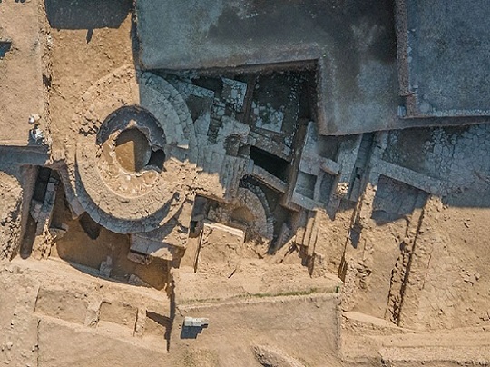
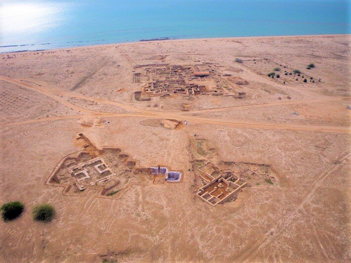
A team of Pakistani and Italian archaeologists have found a 2300-year-old Apsidal temple of the Buddhist period and a treasure in the Bazira city of Barikot tehsil, Swat district in Pakistan.
The location of these artefacts is in the Khyber Pakhtunkhwa province. Know more about the discovery below.
Take a look at the helicopter view of the site found
A senior official said, “The Pakistani and Italian archaeologists during joint excavations at a historic site have discovered over 2,300 years old Apsidal temple of the Buddhist period in north-west Pakistan besides recovering other precious artefacts.
The temple discovered in Swat is even older than the Temples discovered in Taxila remains of Pakistan.”
Professor Luca said, “This is an astonishingly important discovery as it attests to a new architectural shape of Buddhist structure in Gandhara.
We only have one other example of the apsidal temple in a city at Sirkap, Taxila. However, the apsidal temple of Bazira is so far the earliest example of this architecture in Pakistan.”
As per the archaeologists, the temple is almost 2300 years old and along with that 2700 other Buddhist period coins, rings, pots and other artefacts worth millions have been recovered.
An interesting discovery is of something written in the Kharosthi language of the King of Greece, Menander
What is the Inference derived from the discovery?
The head of the Italian archaeological mission in Pakistan Dr Luca Maria Oliver informed that this discovery of the Temple of the Buddhist period is approving of the fact that Swat is home to the oldest archaeological remains than Taxila.
There are many more recoveries expected from this zone of Brazira city. Dr Abdus Samad, the director of museum and archaeology, said, “Bazira city in Barikot Swat is older than Taxila remains too.”
The discovery also proves that Swat had been a sacred place for six to seven religions.
Dr Samad has informed the media that there were 14 archaeological sites under section 4 where the excavation process was carried out.
The Italian ambassador to Pakistan Andreas Ferrarese informed the media, “The Italian archaeological mission in collaboration with Khyber Pakhtunkhwa archaeological department has been protecting and excavating archaeological sites for the last seventy years in Pakistan.”
The site was discovered by archaeologists of Ca’ Foscari University and the Italian Archaeological Mission in collaboration with the provincial department of archaeology and museums.
As per Prof Luca M Olivieri who is the director of Italian Mission, “it is possible to date the foundation of the Buddhist sacred structure to the Mauryan period, certainly to the 3rd century BC.”
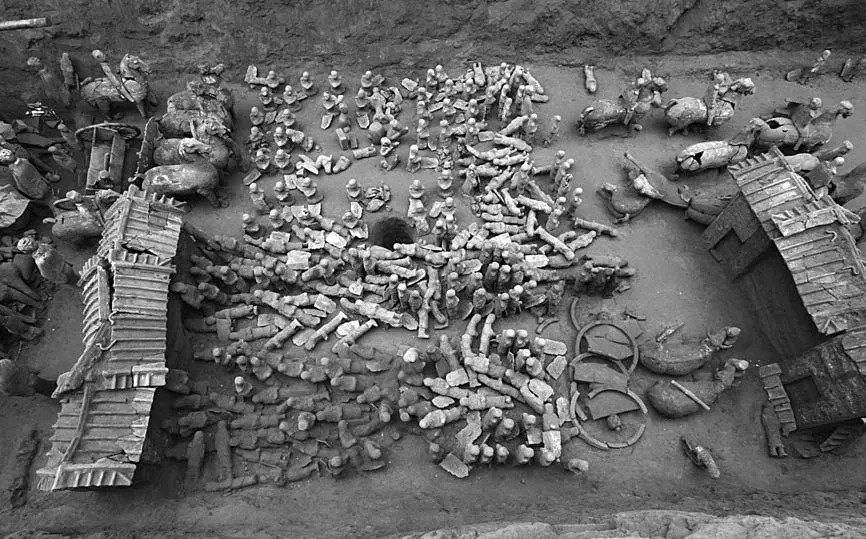
The MINI terracotta army: Hundreds of small warrior statues found in 2100-year-old pit in China
Inside a 2,100-year-old pit in China, archaeologists have discovered a miniature army of sorts: carefully arranged chariots and mini statues of cavalry, watchtowers, infantry and musicians.
They look like a miniaturized version of the Terracotta Army — a collection of chariots and life-size sculptures of soldiers, horses, entertainers and civil officials — that was constructed for Qin Shi Huang, the first emperor of China.
Based on the design of the newfound artefacts, archaeologists believe that the pit was created about 2,100 years ago, or about a century after the construction of the Terracotta Army.
The southern part of the pit is filled with formations of cavalry and chariots, along with models of watchtowers that stand 55 inches (140 centimetres) high. At the pit’s centre, about 300 infantrymen stand alert in a square formation, while the northern part of the pit has a model of a theatrical pavilion holding small sculptures of musicians.
“The form and scale of the pit suggest that it accompanies a large burial site,” wrote archaeologists in a paper published recently in the journal Chinese Cultural Relics.
A 2,100-year-old pit containing a mini “Terracotta Army” has been discovered in China.
The “vehicles, cavalry and infantry in square formation were reserved for burials of the monarchs or meritorious officials or princes,” the archaeologists wrote.
The soldiers and cavalry in the newly discovered army are much smaller than those in the Terracotta Army. Based on the date, size and location of the pit, archaeologists believe that this newly discovered army may have been built for Liu Hong, a prince of Qi (a part of China), who was the son of Emperor Wu (reign 141–87 B.C.).
Hong was based in Linzi, a Chinese city near the newly discovered pit; he died in 110 B.C. “Textual sources record that Liu Hong was installed as the prince of Qi when he was quite young, and he, unfortunately, died early, without an heir,” archaeologists wrote in the journal article. Shortly before Hong’s death, according to writings by ancient historian Ban Gu, a comet appeared in the sky over China.
Where is the tomb?
If the pit and its ceramic army were meant to protect Liu Hong, or another senior royal family member, in the afterlife, then a tomb should be located nearby, the archaeologists wrote.
“There are possibly architectural remains or a path leading from the pit, but there is no way to explore the main burial chamber,” the researchers wrote, noting that the tomb itself may have been destroyed.
Older residents in the area have reported descriptions of a prominent earthen mound, some 13 feet (4 meters) high, near the pit, the study authors wrote. “Sometime in the 1960s or 1970s, workers removed the earth and flattened the area in order to widen the Jiaonan-Jinan Railway.”
The reports are corroborated by an aerial photograph taken in 1938 by the Japanese Air Force (at that time, Japan was at war with China). This picture shows a possible burial mound near the railway, the archaeologists noted.
From life size to mini-warriors
The Terracotta Army pits found beside the tomb of the first emperor of China are the only known examples of an army of life-size ceramic soldiers in China.
Shortly after the first emperor’s 210 B.C. death, his dynasty, known as the Qin dynasty, collapsed and a new dynasty, known as the Han, took over China.
Some of the Han dynasty rulers continued to build pits with armies of ceramic soldiers for their burials, but the soldiers were considerably smaller. For instance, the infantry sculptures in the newly discovered pit are between 9 and 12 inches (22 and 31 cm) tall, nowhere near the heights of the life-size soldiers buried near the tomb of the first emperor.
The pit, along with several other archaeological sites, was discovered in the winter of 2007 during construction work. After its discovery, the pit was excavated by the Cultural Relics Agency of Linzi District of Zibo city.
After excavation was complete, archaeologists from this agency analyzed the artefacts, working with researchers from the Shandong Provincial Institute of Cultural Relics and Archaeology.
A report on the pit was first published, in Chinese, in 2016, in the journal Wenwu. This report was recently translated into English and published in the journal Chinese Cultural Relics.
Could cosmic rays unlock the secret tomb of China’s Qin Shi Huang guarded by terracotta warriors?
Cosmic rays may be used to scan the sealed tomb of China’s First Emperor — long rumoured to contain deadly traps and an ancient map with liquid mercury rivers. Buried under a 249-feet-high pyramidal mound, the tomb lies within a necropolis in Xi’an’s Lintong District and is famously guarded by the Terracotta Army.
Found in their thousands to the tomb’s east, as if to protect Qin Shi Huang in death from the eastern states he conquered in life, each statue was once brightly painted. However, exposure to the dry Xi’an air before appropriate conservation techniques had been devised meant that most of the soldiers’ colours faded after recovery.
For this reason, Chinese officials have long been reluctant to allow the tomb itself to be unearthed until they can guarantee the preservation of any artefacts within. However, new proposals would see subatomic particle detectors placed beneath the 2,229-year-old tomb to map out the structure’s layout in three dimensions.
Qin Shi Huang (259–210 BCE) succeeded in conquering and unifying the whole of China in 221 BCE, creating an empire that lasted for some two millennia.
His other achievements including starting construction on the Great Wall of China, establishing a nationwide road network and standardising writing and units.
His lavish burial site was unearthed in 1974 and has inspired both films and video games, including instalments in both The Mummy and Indiana Jones franchises.
Cosmic rays may be used to scan the sealed tomb of China’s First Emperor — long rumoured to contain deadly traps and an ancient map with liquid mercury rivers
Buried under a 249-feet-high pyramidal mound (pictured), the tomb lies at the heart of a necropolis in Xi’an’s Lintong District, one famously guarded by the Terracotta Army
Found in their thousands to the tomb’s east, as if to protect Qin Shi Huang in death from the eastern states he conquered in life, each statue was once brightly painted. However, exposure to the dry Xi’an air before appropriate conservation techniques had been devised meant that most of the soldiers’ colours faded after recovery — as seen in the examples pictured
For this reason, Chinese officials have been reluctant to allow the tomb itself to be unearthed until they can guarantee the preservation of any artefacts within. Pictured: a map of the necropolis complex, which was modelled after the Qin capital Xianyang. The tomb mound can be seen in the centre of the image, with the inner and outer walls. The Terracotta Army was buried in a ‘garrison’ to the east, between the Emperor and the states he conquered
When high-energy cosmic rays (white line) from space interact with Earth’s atmosphere, they create a shower of subatomic particles — including some called ‘muons’ (solid orange lines) which form from the rapid decay of pions (solid yellow lines)
When high-energy cosmic rays from space interact with Earth’s atmosphere, they create a shower of subatomic particles, including some called ‘muons’.
The scanning technique — ‘muon tomography’ — works as an X-ray, with detectors measuring the rate at which muons are absorbed by the material they pass through.
Just as bones absorb relatively more X-rays than flesh to create contrast in a radiograph, so does stone and metal block the passage of more muons.
The same approach has previously been used, in 2017, to reveal the presence of a previously hidden, 98-feet-long chamber within the Great Pyramid at Giza.
The muon-scanning technique has been proposed by physicist Yuanyuan Liu of the Beijing Normal University and her colleagues, who normally use cosmic rays to investigate the dark matter at the China Jinping Underground Laboratory, which is the world’s deepest cosmic ray facility which is buried some 3.7 miles under the Sichuan province.
‘As an ancient civilisation with a long history, China has a large number of cultural relics that are in need of archaeological research,’ the team told the Times.
‘For the non-intrusive detection of the internal structure of some large artefacts such as imperial tombs, the traditional geophysical methods used in archaeology have certain limitations.
‘The application of muon absorption imaging to the archaeological field can be an important supplement to traditional geophysical methods,’ they concluded.
To put their proposal to the test, the group used existing archaeological and historical data on the mausoleum to build models of the tomb complex.
They then buried these in the ground on top of two muon detectors to show that they could indeed images the chambers in their models.
‘Preliminary imaging results prove the feasibility of muon absorption imaging for the underground chamber of the mausoleum of the First Qin emperor,’ the team said.
The feasibility studies were funded by the central Chinese government.
Based on their tests, the team have concluded that — to scan the real-life tomb — at least two muon detectors, each of which is about the size of a washing machine, would need to be placed in different locations within 328 feet (100 metres) of the tomb’s surface.
This is not the first time that archaeologists and other scientists have tried to use non-invasive methods to map out the inside of Qin’s tomb. Unfortunately, most approaches have limitations that make them difficult to apply to the mausoleum’s particular circumstances.
Gravity anomaly detectors are good at detecting changes in density underground — but such are easily affected by environmental disturbances and their range is limited to a small area.
Pictured: Qin Shi Huang (259–210 BCE), who succeeded in conquering and unifying the whole of China in 221 BCE, creating an empire that lasted for some two millennia
Ground-penetrating radar, meanwhile — a favourite of archaeological geophysicists — suffers from a too limited depth to be of much use here.
These studies have succeeded in revealing, however, that an underground complex of some kind and state of preservation does extend some 98 feet beneath the pyramidal mound. Archaeologists believe that there is a good chance that the subterranean chambers may still be intact. Certainly, no evidence has been found that graverobbers have ever succeeded in tunnelling their way into the tomb.
Geophysicist Yang Dikun of the Southern University of Science and Technology in Shenzhen — who was not involved in the present study — told the South China Morning Post that the latest proposal to scan the Emperor’s tomb was feasible.
‘The muon detectors that we build and use for fieldwork nowadays have become so small they can be carried around by a child,’ he commented.
However, Dr Yang warned, the cosmic ray approach is not without potential challenges — the main one being that the detectors have to be physically emplaced underneath the mausoleum complex without damaging it or the artefacts within.
It also required considerable patience, he added. Unlike other imaging techniques, muon tomography is far from instantaneous, and the detectors will need to operate until they have racked up enough particle counts for meaningful analysis.
In fact, simulations by Dr Liu and her team have suggested that — to produce a clear image of the tomb’s structure — the detectors would need to be left in place for at least one year. The full findings of the study were published in the journal Acta Physica Sinica.
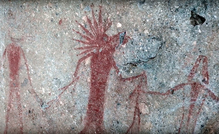
5,000-Year-Old Rock Art Depicting “Celestial Bodies” Revealed in Siberia
Some 5,000 years ago, artists in Siberia drew some of the most sophisticated artwork the region has ever seen. The ancient artists were depicting humanoid figurines with strange halos and horns and ensured their message was inscribed in history.
Analysis of the art has revealed the secrets of the prehistoric artists behind the stunning artwork known as the Karakol paintings, reports the Siberian Times.
Ancient Rock Art
Discovered in the remote Altai mountains, the ancient artists of the region drew a series of humanoid figurines with strange additions: some of them have round horns, halos, while others are depicted with feathers on their heads.
The artwork was discovered inside a burial in the Karakol village in the Altai Republic. And although the drawings were discovered back in 1985, it isn’t until now that they have revealed unexpecting secrets.
Different figurines were drawn by the ancients some 5,000 years ago.
The mysterious interpretations of humanoid figurines were paintings on stone slabs that were later used as walls of the burials.
Scientists were stunned after finding out that the ancient drawings were made in three distinct colours: white, red, and black, marking the first case of polychrome rock paintings ever found in Siberia.
Intricate Burials
Not only did experts find evidence of rock art in the burials, but they also discovered that the remains of people inside the burials were also painted with the same colours.
The analysis revealed traces of red ocher and a black and silvery mineral called Specularite, used by the ancient artists to decorate the burials. Researchers have revealed that the images on the stones were drawn at different times using elaborate techniques.
Among the earliest rock art, we find depictions of elks, mountain goats, and humanoid figurines which the ancients drew, running around with round horns and halos on their heads.
Mysterious rock art from Siberia.
To complete some of the drawings, the ancient humans did more than just mix engraving techniques and mineral paints. The research revealed that the ancient artists knew how to carry out chemical reactions more than 5,000 years ago, creating not just a colour but the precise tone they wanted to obtain.
“The results of the analysis of the composition of paints used in the funeral rite of Karakol people testify to the ability of the ancient inhabitants of Altai to distinguish pigments by colour and properties,” explained Alexander Pakhunov, one of the authors of the study.
Scientists from the Kurchatov Institute in Moscow, Russia’s leading research and development centre for nuclear energy, and experts from the Paleo-Art Centre of the Institute of Archeology discovered that the figurines were drawn in red colour are actually made of thermally modified ocher.
The ancient Artists knew how to produce exact colours and tones.
The Siberian Times noted that the white-coloured drawings were created by scraping, which revealed light-reflecting rock crystals.
While for the black colour, the ancient artists of Karakol made use of soot.
“We determined the phased composition of pigments, that is, the structure of the crystal lattice of individual grains of the dye. Some structures are not typical for natural samples but are the product of heat treatment,” revealed Roman Senin, the head of the Kurchatov Institute’s synchrotron research department.
“Simply put, the primitive artist heated the mineral to a certain temperature to get the colour he needed,” Senin added.
Just Under the Island’s sandy soil, archaeologists are discovering complex history extending back 4,000 years
A forgotten sliver of land in the far north of the Persian Gulf, Kuwait’s Failaka Island is home now mostly to camels. Its only town is a sprawling ruin pockmarked with bullet holes and debris from tank rounds, and the landscape beyond seems empty and bleak.
An aerial view of Kuwait’s Failaka Island shows four different sites representing thousands of years of civilization.
Even before Iraq’s 1990 invasion of Kuwait prompted its sudden evacuation, Failaka in the past century was little more than a quiet refuge for fishermen and the occasional Kuwaiti seeking relief from the mainland’s fierce heat. But just under the island’s sandy soil, archaeologists are discovering a complex history extending back 4,000 years, from the golden age of the first civilizations to the wars of the modern era.
The secret to Failaka’s rich past is its location, just 60 miles south of the spot where the Tigris and Euphrates Rivers empty into the Gulf. From the rise of Ur, the world’s largest metropolis in the late third millennium B.C., until Saddam Hussein’s attack during the First Gulf War, the island has been a strategic prize. For thousands of years, Failaka was a key base from which to cultivate and protect—or prey on—the lucrative trade that passed up and down the Persian Gulf. In addition, there were two protected harbours, potable water, and even some fertile soil. The island’s relative isolation provided a safe place for Christian mystics and farmers amid the rise of Islam in the seventh and eighth centuries A.D., as well as for pirates a millennium later.
Currently, archaeological teams from no less than half a dozen countries, including Poland, France, Denmark, and Italy, are at work on Failaka. Given the political volatility of neighbouring nations such as Iraq, Iran, and Syria, the island offers a welcome haven for researchers unable to conduct their work in many other parts of the region. “I started encouraging teams to come in 2004,” says Shehab Shehab, Kuwait’s antiquities director. “And I want to encourage more.”
The oldest settlement on Failaka was long thought to have been founded in about 1800 B.C. by the Dilmunites, a maritime people who likely hailed from what are today’s Bahraini and Saudi Arabian coasts, and who controlled the Persian Gulf trade. But on Failaka’s southwest corner, a team from Denmark’s Moesgård Museum has uncovered evidence that Mesopotamians arrived at least a century before the Dilmunites.
The finds are centred on a recently unearthed Mesopotamian-style building typical of those found on the nearby Iraqi mainland dating from around 2000 B.C. The structure was later partially covered by a Dilmunite temple.
In the mythology of ancient Sumeria (modern Iraq), Dilmun is described as an Eden-like place of milk and honey. But by 2000 B.C., Dilmunites were leaving their homeland to become seagoing merchants and establish a powerful trading network that eventually stretched from India to Syria. Mesopotamian clay tablets refer to ships from Dilmun bringing wood, copper, and other goods from distant lands. By the nineteenth century B.C., Failaka had become a linchpin in the Dilmunites’ operations. At this point, after the Dilmunites had either ousted the Mesopotamians or merely succeeded them, there are no further signs of a Mesopotamian presence.
The Dilmunites constructed a large temple and palace complex almost on top of the houses built by the earlier Mesopotamian residents. A French team that excavated the temple in the 1980s suggested that it was an oddity, possibly related to Syrian temple towers. But recent work by a team from the Moesgård Museum in Denmark points to a building remarkably similar to the Barbar sanctuary in Bahrain, considered the grandest Dilmun structure.
Failaka’s name is derived from the Greek word for the outpost. But Alexander the Great, according to later classical authors such as Strabo and Arrian, gave Failaka the name Ikaros, since it resembled the Aegean island of that name in size and shape. French archaeologists working on the island in recent years have found several stone inscriptions dating to the fourth and third centuries b.c. mentioning the name Ikaros, as well as architecture and artefacts that reveal a bustling community with international ties during that period.
The island’s accessible freshwater easily defended coastline and strategic location also attracted the attention of Alexander’s successors, who vied among themselves for control of regional trade routes. Antiochus I, who ruled the Seleucid Empire in the third century B.C., built a 60-foot-square fort around a well on Failaka. Inside the fortress compound, one small, elegant temple has Ionic columns and a plan that is quintessentially Greek, including an east-facing altar. This was no simple import, however, but a fascinating amalgamation of designs. The column bases, for example, are of the Persian Achaemenid style, similar to those in the capital, Persepolis, burned by Alexander’s troops in the fourth century B.C.
The centre of Failaka is a low-lying swampy area that is now the province of mosquitoes and wandering white camels that belong to the Kuwaiti emir. But a millennium ago, this was a three-square-mile pocket of fertile and well-watered plain cultivated by a small community of isolated Christians in a region populated by Muslims. Previous French excavations revealed several villages and two churches, including a possible monastic chapel.
A Polish team led by Warsaw-based archaeologist Magdalena Zurek is now busy excavating nearby sites to understand the extent of the settlements that flourished in the eighth and ninth centuries A.D., several hundred years after the faith inspired by Muhammad swept through the region. “We know nothing about Christians on Failaka,” says Zurek, who suspects that a third church lies near her current excavation of a modest farmstead.
The story of Failaka after the abandonment of the Christian villages remains shadowy. Currently, archaeologists are turning their attention to several sites that sit along the northern shore of the island to probe the medieval and early modern periods. The most interesting is located on a high spot overlooking the gulf, facing Iraq. Nearly 30 years ago, a team from the University of Venice surveyed the site, pinpointing a village, called Al-Quraniya, that dates to at least as early as the seventeenth century A.D., and possibly several centuries earlier. In 2010, an Italian team led by Gian Luca Grassigli of the University of Perugia began intensive fieldwork there.
The excavators have since uncovered an array of pottery, porcelain, glass bangles, and bronze objects, including nails and coins, dating to between the seventeenth and nineteenth centuries A.D. The mound seems to have two large concentrations of building materials, and the archaeologists hope to make a detailed plan of the settlement in future campaigns. Deeper trenches may reveal evidence of earlier settlement, filling in the long gap between the abandonment of Christian villages and more recent times.
What is clear is that Failaka was still a notable outpost two millennia after Alexander. Just to the southeast of the village is a small square rock fort dating to about the sixteenth or seventeenth century.
Some researchers believe that this structure was constructed by Portuguese soldier-merchants who did frequent business in the region. others suspect that Arab pirates built the base to attack the lucrative shipping lanes that led to wealthy Iraqi cities such as Basra or to ports along the Iranian coast to the east. In this era, European, Iranian, and Chinese elites had a growing appetite for the gulf pearls that dominated the region’s economy. Pirates were a constant threat until the nineteenth century; British guns and diplomacy put an end to their raids.
Pirate hideout.
The mainland of Kuwait is mostly a harsh desert, with only a handful of significant ancient sites. Even the old town of Kuwait City, dating back two centuries, was long ago demolished to make way for skyscrapers. Thus Failaka is of prime importance to the country’s heritage. Recently, much of the island’s history was threatened by a plan to transform the barren land with its rocky coast into a major tourist magnet, complete with marinas, canals, spas, chalets, and enormous high-rise hotels and condominiums. In the wake of the global economic recession, however, the $5 billion projects foundered and was recently shelved. Shehab has moved into the resulting vacuum, lobbying hard to turn all of Failaka into a protected site in order to enable archaeologists to uncover, study, and preserve this small nation’s past.
The government already sets aside more than $10 million annually to cover the costs of foreign projects in Kuwait, and hopes to promote science as well as encourage heritage tourism. “Shehab’s dream is to create in Kuwait a kind of research centre for Gulf basin archaeology,” says archaeologist Piotr Bielinski from the University of Warsaw, who is digging at a prehistoric site on the mainland just north of Kuwait City.
And excavators on Failaka are making the most of this unique opportunity, exposing evidence of Mesopotamian merchants, religious structures representing three cultures and spanning more than 2,500 years, a pirate’s lair, and the remains of Failaka’s last battle, ample testimony to the island’s millennia-long endurance.
This was once one of ancient Israel’s most powerful cities
Gezer used to be a major city. Some 3,000 years ago, this settlement – situated between Tel Aviv and Jerusalem – was considered one of the main regional cities, along with Jerusalem and Beit She’an.
Down the rabbit hole: Visitors to Gezer’s ancient water system.
Twenty-five layers of habitation have been found here during decades of archaeological excavations. Its earliest structures were built about 5,500 years ago.
The Bible recounts how the king of Egypt “had taken Gezer and burnt it with fire,” giving it as a loving wedding gift to his daughter who married King Solomon (1 Kings 9:16). Solomon subsequently rebuilt the city.
There is always a crucial question when it comes to ancient sites: what can we see there today? Are these just piles of “important” ruins, or can you actually enjoy the place and is it interesting?
Tel Gezer offers several wonderful observation points.
It can get a bit dark in the ancient water system at Gezer.
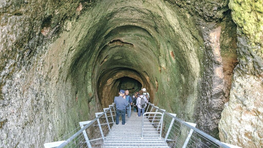
With Gezer, the answer is a resounding yes – especially now its ancient water system is open to the public.
The residents of Gezer dug out this water system 3,600 years ago in order to reach groundwater. It’s the largest Canaanite water system ever discovered, established around 600 years before the presumed reign of King Solomon.
On the eastern side is Solomon’s Gate and the Canaanite steles, an area used for worshipping that features a stone basin and 10 huge stone monuments.
The first person to find it was the Irish archaeologist Robert Macalister, in the early 20th century. That excavation also yielded the Gezer calendar – one of the earliest Hebrew inscriptions, which is now on show in an Istanbul museum.
The water system was blocked over the years and only recently excavated. A new stairwell has been installed, allowing us to look and be amazed.
The system is 90 meters long and 7 meters high (295 x 23 feet), and groundwater is used to accumulate at the bottom, at a depth of some 40 meters. This pool is currently dry (you should bring a flashlight when visiting).
The water system is not the only attraction. There is also a Canaanite gate that served as the entryway into the city, flanked by a high guard tower.
These are the largest such fortifications found in Israel to date.
On the eastern side is Solomon’s Gate and the Canaanite steles, an area used for worshipping that features a stone basin and 10 huge stone monuments. The western end of the site boasts large jujube (Ziziphus) tree, providing pleasant shade.
Tel Gezer offers several wonderful observation points, allowing you to gaze over the green fields and beautiful vineyards surrounding the moshav of Karmei Yosef.
Tel Gezer seen from the air.
The western side also features the tomb of Sheikh Mohammed al-Ghazali. Up until 1948, 1,000 residents of the Arab village of Abu Shusha lived next to the archaeological mound.
They grew cereals and fruit trees. The village’s houses were all destroyed when the village was conquered during the War of Independence.
Spring can be found southeast of the site with a memorial honouring Itay Steinberger from Karmei Yosef, who fell during the Second Lebanon War in 2006.
“China is the first country in the world to discover and cultivate tea,” said Professor Shuya Wei from the Institute of Cultural Heritage and History of Science & Technology at the University of Science and Technology Beijing and her colleagues.
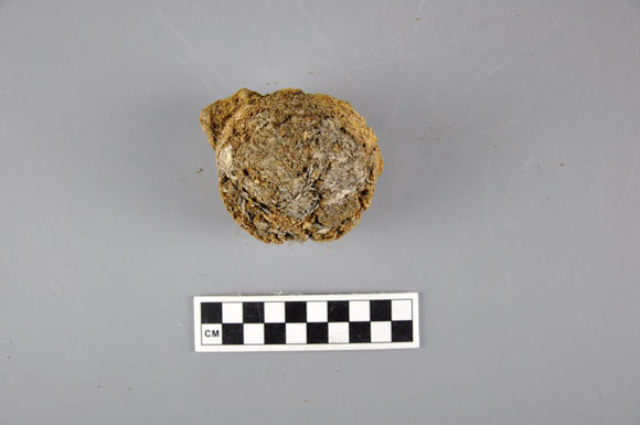
A small tea bowl was found in the ancient capital of the Zhu Kingdom in Zoucheng, Shandong province, China.
“In Chinese legend, tea was first discovered as an antidote by Emperor Shen Nung in 2737 BCE, according to the first monograph on Chinese herbal medicine Shennong’s Classic of Materia Medica.”
“The first mention of tea planting is believed to occur in the Xiaxiaozheng, a Chinese earliest almanac recording traditional agricultural affairs, probably written in the Warring States period (475-221 BCE).”
“According to the literature, in the Spring and Autumn period (770-476 BCE), tea had been used as a sacrifice and vegetable, in the Warring States period and the early Western Han dynasty, tea cultivation, tea making techniques and tea-drinking custom in Sichuan province began to spread to other places.”
The physical evidence of tea is very important to confirm the origin, development, function and culture of tea.
“As archaeological plant leaves remain have been buried for many years, most of them have rotted or charred, it is difficult to find archaeological plant leaves remains in archaeological excavation,” the researchers explained.
“Recently, 2,400-year-old charred tea remains were found in a bowl unearthed from tomb No. 1 at Xigang in the ancient capital city site of the Zhu Kingdom in Zoucheng City, Shandong province.”
“If the remains could be determined as tea, that would be the direct evidence for tea drinking in the ancient time.”
The 2,400-year-old tea residue from a bowl was found in the ancient capital of the Zhu Kingdom in Zoucheng, Shandong province, China.
In the study, Professor Wei and co-authors analyzed the sample from the Warring State tomb using Fourier transform infrared spectroscopy (FTIR) and several other methods. They used modern tea and modern tea residue as reference samples.
Their results show that the sample contains abundant calcium phytoliths identifiable as tea and that its FTIR spectra are similar to that of the modern tea residue.
They also detected caffeine, methoxybenzene compounds, organic acids, and several other compounds in both the ancient sample and the modern tea residue.
“Since ancient times, the Chinese people have always had the habit of drinking tea, but there is no physical evidence to prove when tea actually appeared, until the discovery of tea in the Han Yangling Mausoleum, which proved that Chinese tea has a history of at least 2,150 years, which has earned recognition from Guinness World Records as the oldest tea in 2016,” the scientists said.
“The identification of the tea remains in Zoucheng — the early stage of Warring States, approximately 2,400 years ago — has advanced the origin of tea by nearly 300 years.”
“Furthermore, the tea was found in a small bowl, providing additional evidence of the usage of tea.”
“Our results indicate that tea drinking culture may start as early as in Warring State period.”
The findings were published in the journal Scientific Reports.
Skeletons Found near-dead Sea Scrolls likely belonged to an Enigmatic Religious Group
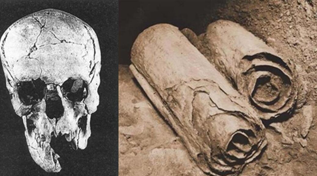
More than 30 newly discovered 2,200-year-old skeletons could finally help to reveal who wrote the ancient Dead Sea Scrolls. Remains found near the site where the scrolls were discovered suggest the bodies were linked to a celibate Jewish brotherhood known as the Essenes.
The Dead Sea Scrolls have fascinated scholars and historians since the ancient texts were found around 70 years ago scattered within a series of caves in the West Bank.
Thought to have been written between 200 BC and 100 AD, the scrolls inscribe some of the oldest known foundations of the Old Testament.
Despite experts citing the texts as among the biggest archaeological finds of the 20th Century, their origins and authorship have remained a mystery for decades.
More than 30 newly discovered 2,200-year-old skeletons could finally help to reveal who wrote the ancient Dead Sea Scrolls. Remains found near the site where the scrolls (file photo) were discovered suggest they were linked to an ancient Jewish group known as the Essenes
Ever since their discovery, a number of suggestions have been put forward as to who created or oversaw the texts, including soldiers, craftsmen, people from the Iron Age, or Bedouins.
Now an analysis of remains found in 33 newly uncovered graves could help experts to understand the mysterious texts’ history.
Analyses of the bones support a previous theory that the scrolls were written or guarded by members of a celibate, all-male Jewish sect called the Essenes. The mysterious group flourished in Palestine from the 2nd century BC to the end of the 1st century AD.
Like the scrolls themselves, the graves were found in Qumran, an archaeological region in the West Bank along the northwestern shore of the Dead Sea. Anthropologists from the Israel Antiquities Authority in Jerusalem radiocarbon-dated the bones, revealing they are about 2,200 years old, around the same age as the scrolls.
But it was not just the age of the bones that linked them to the ancient texts.
All but three of the 33 skeletons were identified as probably male, based on factors such as body size and pelvic shape.
The Dead Sea Scrolls have fascinated scholars and historians since the ancient texts were found around 70 years ago scattered within a series of caves in the West Bank
The remaining remains may have belonged to men too, but not enough skeletal evidence exists to be sure.
Of the 30 skeletons identified as male, each was aged between 20 and 50 – or possibly older – when they died.
These parallels suggest the skeletons were once members of the mysterious Essenes crypt, the researchers claimed.
‘I don’t know if these were the people who produced the Qumran region’s Dead Sea Scrolls,’ project scientist Dr Yossi Nagar told ScienceNews.
‘But the high concentration of adult males of various ages buried at Qumran is similar to what has been found at cemeteries connected to Byzantine monasteries.’
Given the lack of signs of injury on their bones, the men were unlikely to have been soldiers, the researchers said. Dr Nagar presented the findings last Thursday during the annual meeting of the American Schools of Oriental Research.
As there appear to be no women in the burial, the group was likely a ‘community of ideologically celibate men… child proportion and adult age at death distribution match the common desert monasteric societies of the subsequent periods’, the researchers, led by Dr Nagar, wrote in their paper.
Previous finds at sites around Qumran have suggested it was founded more than 2,700 years ago. The people of Qumran abandoned the area after the war tore the region apart, returning to reoccupy it for 200 years, up to around 68 AD. An early theory on the creation of the Dead sea Scrolls claimed that members of an ancient, celibate Jewish sect, the Essenes, lived in Qumran.
Thought to have been written between 200 BC and 100 AD, the scrolls inscribe some of the oldest known foundations of the Old Testament
The theory says the group either wrote the Dead Sea Scrolls or were caretakers of the legal, philosophical and religious documents. Over the past 30 years, many other theories have been put forward, including that the scrolls were written by Bedouin herders, craftsmen and Roman soldiers.