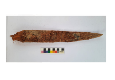
Iron dagger with wooden handle, skeletal remains found at Konthagai, India
The 40-cm-long weapon with a 6-cm-long wooden handle was found at a depth of 77 cm.
The sample will be sent to Beta Analytical Lab, Florida, USA, for exact dating.
An iron dagger with a wooden handle was found inside a burial urn unearthed at Konthagai village, which is part of the Keeladi cluster where the seventh phase of excavation is in full swing to establish the existence of urban civilisation in the Sangam era.
The second season of digging started in February at Konthagai where 25 burial urns have been unearthed so far and 11 of them have been opened, according to R. Kaviya, one of the four Site Archaeology Officers.
These urns measure 95 to 105 cm in height with a circumference of 80 cm. Some of the urns contained iron weapons, shaped like knives, and spears and small terracotta vessels.
The latest, a 40-cm-long iron dagger with a 6-cm-long wooden handle was found at a depth of 77 cm. The urn filled with soil sediment had the five-cm-thick dagger, associated with femur bones, a skull and an offering pot.
It is a type used by warriors belonging to the Sangam period, contemporary to Keeladi dating, according to R. Sivanandam, Director of Keeladi Excavations.
This was the first time that they had stumbled upon a weapon with a wooden handle, and it would be very useful for exact dating of the evidence found so far, he said.
Though extremely fragile, the wooden handle was preserved in rare natural phenomena and collected carefully in foil covers. The sample would be sent to Beta Analytical Lab, Florida, the USA, for an exact dating, added Mr. Sivanandam, who is also the Commissioner (FAC), Department of Archaeology.
25 burial urns have been unearthed so far in Keeladi
The skeleton samples were handed over to experts at Madurai Kamaraj University, where a DNA testing laboratory is coming up.
Ms. Kaviya said the urn was found with a disturbed lid. The broken portion of the lid was retrieved inside the urn at a depth of 80 cm.
There was a possibility that the broken portion of the urn lid fell on the iron dagger, as two urn lid pieces were found on either side of the dagger, which was also damaged.
The Keeladi excavations are being carried out by the Archaeological Survey of India under the supervision of Minister for Industries Thangam Thennarasu and B. Chandramohan, Principal Secretary, Tourism, Culture & Religious Endowments Department.
Stone Age tools, cave paintings discovered in India could be clues to ‘prehistoric factory’
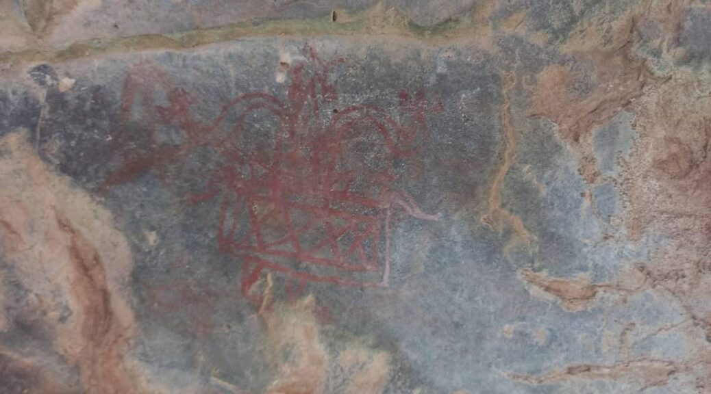
Mangar, Haryana: Prehistoric cave paintings belonging to the Paleolithic era, and rock shelters as well as tools and tool-making equipment, presumably dating back to the lower or early Paleolithic era have been found hiding in plain sight in the Aravallis.
A specimen of recently discovered palaeolithic cave paintings in the Aravalli Range in Haryana, India.
The palaeolithic era, or the Old Stone Age, dates back to 10,000 BC when humans still lived as hunters and gatherers. Tools belonging to the Stone Age have been found in rock shelters as well as in open-air sites, spread across nearly 5,000 hectares, Banani Bhattacharya, Deputy Director, Haryana Department of Archaeology and Museums, told ThePrint.
Located in the Aravalli hills near Mangar Bani forest along the Gurugram-Faridabad stretch in Delhi-NCR, the discovery is monumental as it changes the understanding of Haryana’s history, pushing it back further by several thousand years than we currently know.
“Haryana is known as the cradle of Indian civilisation. Earlier, 28 sites dating back to the Harappan and pre-Harappan era had been discovered in the state. However, cave paintings and rock art sprawling in such a large area have been discovered for the first time. This discovery suggests that the history here could be 1 lakh years old,” Bhattacharya said.
While the Aravalli range is known for housing pre-historic remains, the latest discovery is the first time rock paintings have been found here. While the rock art and tools are estimated to be about 1 lakh years old, the paintings might not be older than 20,000-40,000 years, according to Bhattacharya.
The estimates, though, are preliminary and need further research, documentation and carbon dating to accurately determine the exact time period this site belongs to.
Based on initial observations, Bhattacharya said, it appeared humans had settled in this area for quite some time as the archaeologists noticed that the pattern of drawing had evolved. This gives them a chance to trace how early humans developed their tool-making skills.
A specimen of the palaeolithic paintings found in the Aravallis
“Some are line drawings, which are the oldest when humans hadn’t really figured out how to draw complex patterns. Then we can see drawings of different geometric shapes, foliage, animals and human figures. We’ve found some symbols that look like cup marks, which had presumably been kept for some special purpose,” Bhattacharya said. “While most are ochre, some are white as well. Which means those particular drawings belong to the historic era.”
Bhattacharya also said this could be the biggest Paleolithic site found in the subcontinent. She said this could well be the ‘factory’ of our ancestors, where tools were made.
YouTube video leads to discovery
A YouTube video, posted in May by residents of the area, tipped the Haryana archaeological department to the site, which was discovered later in July.
“We were planning to carry out a survey in the Aravallis here. In May, a video surfaced on YouTube about these caves that villagers have been aware of. However, they never understood the value of these rock carvings and paintings, so we were never alerted earlier,” Bhattacharya said.
No elaborate archaeological survey of the Aravallis has been carried out in this area yet, which, Bhattacharya said, will be done soon. “We’re planning to map the entire Aravalli stretch.”
Another reason the paintings weren’t officially discovered so far was that it takes hiking on undefined trails to reach some of the sites. Over time, the paintings also eroded, thus escaping most untrained eyes. At some sites, dense vegetation covers up the palaeolithic art.
Bhattacharya and her team carried out a three-day survey in the last week of June, identifying several sites. With final documentation and more elaborate research pending, Bhattacharya is yet to have a final count of the number of sites discovered so far.
Wildlife researcher and conservationist Sunil Harsana, who claims he had first posted the video to YouTube, said he has been aware of the caves since his childhood but didn’t understand the significance of the paintings and didn’t know who to talk to about them.
“We had a keypad, basic phones with the bad camera till as late as 2016… so even if I had clicked a picture on them, nobody would’ve understood what I was talking about. And we didn’t know who to tell. Now, once they were put on the internet, they got the attention they deserved,” he said.
Protecting the history
Currently, the sites are exposed and vulnerable — along with what remains of the Stone Age. The trash from the current millennium — such as empty cans and bottles of beer and cola, cigarette butts, empty wrappers of snacks — can also be found here.
Harsana is wary that as more people find out about the discovery, more will come to visit these rock shelters, speeding up the deterioration.
“The site needs urgent protection. You never know who will visit the site and carve their name or ‘hearts’ alongside the prehistoric carvings, just for the fun of it,” he said. Instead, through heritage and eco-tourism, residents of the area could find employment opportunities and be able to earn some.
Both Bhattacharya and Harsana are also of the opinion that Mangar Bani and its surrounding forests on the Gurgaon-Faridabad Aravalli stretch should be declared a heritage-eco zone. This will guarantee the area is protected from illegal mining and encroachment.
“We don’t even know how many of these sites must have been destroyed because of mining and exploitation of the Aravallis. They need urgent protection. As the oldest mountain range in the world, they carry important clues to help us understand our origins and have a lot of stories to tell about the Indian subcontinent,” Bhattacharya said.
Ashok Khemka, Principal Secretary to Haryana government, told Hindustan Times earlier this month the department will be issuing orders to protect Mangar Bani under Section 4 of the Punjab Ancient and Historical Monuments and Archaeological Sites and Remains Act, 1964, and that experts in palaeolithic cave paintings will be carrying out an extensive survey of the area.
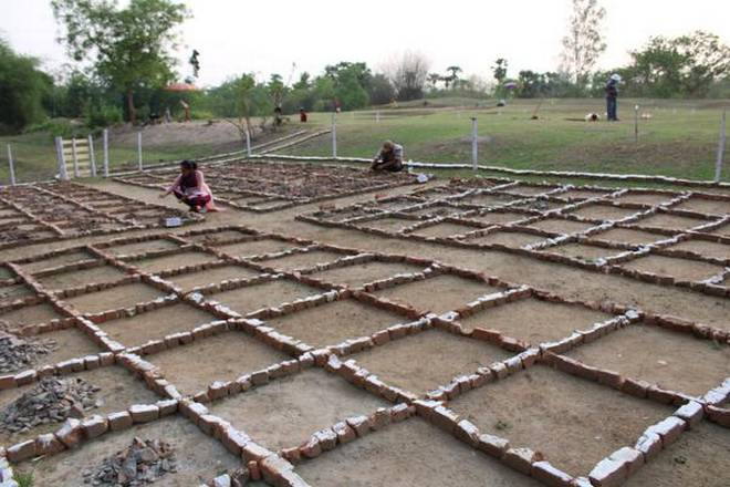
4,000-Year-Old Settlement Unearthed in Eastern India
In the Balasore district, the Odisha Institute of Maritime and South-East Asian Studies (OIMSEAS), an archaeological branch of the state government, found a 4,000-year-old settlement and ancient relics.
The OIMSEAS had requested permission from the Archaeological Survey of India (ASI) to record the site at Durgadevi village in Remuna tehsil after discovering indications of fortified early historic structures near Balasore town.
Durgadevi has located 20 km from Balasore town. According to the ASI, the site has a circular mud fortification of about 4.9 km between the Sona river to the south and the Burahabalang river on its northeastern margin.
Archaeologists have come across distinct traces of three cultural phases at the excavation site — Chalcolithic (2000 BCE to 1000 BCE), the Iron Age (1000 BCE to 400 BCE) and the Early Historic Period (400 BCE to 200 BCE).
“Two small nullas, Gangahara and Prassana, join the site on its north and south, forming a natural moat for the site, which was an ancient water management system developed at least 4,000 years back from the present,” the institute said.
The excavation was started with an aim to correlate the simultaneous growth and development of maritime activities, and urbanisation in the east coast of India, linking the Ganga valley in the north and the Mahanadi valley in central Odisha, more particularly to focus on early cultural development in northern Odisha, the institute informed.
According to the OIMSEAS, horizontal excavation was concentrated in an area of two acres of high land, where a cultural deposit of about 4 to 5 meters was seen.
Archaeologists have come across a human settlement, and artefacts belonging to the Chalcolithic period.
“The major discovery of the Chalcolithic period of Durgadevi is the base of a circular hut, black on red painted pottery, black slipped ware, red slipped ware and copper objects. The floor of the circular hut is rammed with red soil,” Sunil Kumar Pattnaik, archaeologist and Secretary, OIMSEAS.
“From the base of the circular hut and the utilitarian objects found, the lifestyle of the people has been derived. People were mostly leading a settled life and had started agriculture, and domestication of animals and fishing,” he said.
Similarly, the cultural material evidence and remains found from this phase include pottery, remains of black burnished ware, black and redware, iron objects like nails, arrowheads, and crucible and slag of various kinds belonging to the Iron Age.
“The use of iron is a landmark phase in the growth of civilisation in Odisha, particularly in north Odisha. There are several iron age sites discovered by various archaeologists in the upper and middle Mahanadi valley, but in north Odisha, this is the first site,” said Mr. Patnaik.
Cultural materials from the early historic period such as pottery specimens of redware, terracotta ear studs, bangles, beads, and some conical objects, were also discovered from the site.
“The lifestyle of the people, which is derived from the cultural materials, was very improved at that time, from an agricultural base to trade and construction of fortification around the site with a moat, which signify the emergence of urbanisation at Durgadevi around 400 BCE to 200 BCE,” said the OIMSEAS Secretary.
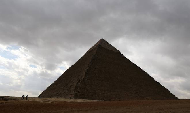
Egyptian Pyramids, Mayan Pyramid Temples, Babylonian Ziggurats (Shikara in Sanskrit) and Hindu temples—all look like a cone. The design and structure are same. Hindus were the originators. Hindus taught the world that God lives in a high place-sacred mountain MERU.
The Greeks changed the name to Mount Olympus. Hindus are the only race in the world continuing temple buildings in the same way and worshipping God in it. All others made them as museums.
We took this concept of ‘sacred mountain’ to Cambodia and built the largest temple complex in the world Angkor Wat and Borobudur in Indonesia. We used the temple for Gods, where as others used them for God like kings.
Scholars around the world knew the connection between India and Egypt from 1400 BC. That was the time Mittanni King Dasaratha wrote ten letters (it is available in all the encyclopaedias as Amarna letters) after marrying his daughter to Egyptian king Amhenotep (Sramana Dev). Tushratta/ Dasaratha was a king who ruled Syria (now a Muslim country), but his name and his forefather names are in Sanskrit.
To confirm they are Indian Hindus we have an inscription giving the Vedic Gods Mitra, Varuna, Indra and Nasatya (Asvini Devas) in an agreement with the Hittites and a horse manual with Sanskrit numbers.
(Though all these things were in encyclopaedias from 1930s, the ruling British were very careful not to teach this or about South East Asian Hindu Empire to Indian History students. All these excavations were done by non British scholars! British were very successful in sowing the poisonous seeds of divisive Aryan Dravidian Invasion theory which is not in Sangam Tamil or Sanskrit literature.
They carefully hid facts like Tamils worshipped Indra, Varuna, Vishnu, Skanda and Durga which was found in the oldest Tamil book Tolkappiam).
Bible which was put to writing around 945 BC (Hutchinson Encyclopaedia) also gave Sanskrit words for imports from India such as karpasa (cotton),Tuke (Siki for peacock or Suka for parrots), Kapi (monkey)etc.
But many of us do not know that the first king of Egypt was Manu, the law giver. But they were not Dasaratha of Valmiki Ramayana or Manu of Manu Dharma Sastra.
Many of us do not know that the Egyptian builders used the Sanskrit word Sutra for measurements during building Egyptian Pyramids.
Sulba Sutras are Vedic manuals giving measurements for Yaga Kundas (fire pits for sacrificial fire ceremonies). It contains Pythagorean Theorem and other Vedic mathematics. Sutra means thread/plumb line,also book of formulas.
He was the most revolutionary king who established ONE GOD for the Egyptians. His name in Sanskrit means Eka Aten (One Aten is God). He worshiped Surya (sun).
Egyptian kings’ sun worship looks exactly like Brahmins doing Sandhyavandhana. Brahmins do it thrice a day facing sun. Egyptian kings worship the sun in the same way.
Manu=Nara Meru
In my earlier posts I have established that the big conflict between Krishna/Arjuna pair and the Nagas under the leadership of Maya Dhanava just before 3100 BC resulted in a mass exodus of Nagas to South America and Central America.
After Krishna’s burning of Naga lands (Kandava vana) in the Gangetic plains, there were continuous clashes. It was followed by the mass execution of Nagas (Sarpa Yagna) to avenge the assassination of King Parikshit by the Nagas. A Naga hid himself in the fruit basket and killed King Parikshit.
Around 3100 BC another dynasty started their rule in Egypt. Since they were Hindus, they named the first king Manu (Manes). His other name was Narmer i.e. Nara Meru, a pure Sanskrit word meaning Mountain among the Kings. Meru was the holiest and highest mountain in Hindu Mythology. Any high point was named Meru.
We have different Merus around the world. Pameru (Pamir Plateau), KuMeru (Kumari in the South of India). Su Meru (Sumerians) of the Middle East. The word Khmer of Cambodia may be related to Kumari/Ku Meru. I will write about it separately. North and South Poles were also called Merus in Hindu Mythologies (Puranas).
Menes was given a legendary date 3100 BC by the Greeks because Indian Kaliyuga Calendar begins in 3102 BC. Mayans also followed this Kali Yuga Calendar. (Full details are in my posts)
Menes (Manu) was praised the first Law Giver of Egypt by the Greek Historian Diodorous Siculus. Egyptians were just like Indian Hindus. They believed kings were half God, half man. Indian words for kings and palaces are synonymous with Gods and Temples. Diodorous links Heracles (Hercules) with Egypt and India. Hercules was one of the 12 ancient Gods of Egypt and he cleared India of wild animals, says Diodorous.
Narmer palette shows his picture as a strict man punishing the wrong ones.
( In Tamil Khon means King and God, Koil means Palace and temple, In Sanskrit Deva is used for Lord and the King). Khon became Khan in other languages like Kesari/lion gave a new word Caesar. Tele in the Ancient Middle East means temple, which is the corrupted form of Sanskrit word STHALA. Tamils changed it to Thali=temple)
Egyptian kings called themselves children of Surya/sun. This corresponds with the Surya Vamsa of Hindu scriptures. Like Indian Hindu kings, Egyptian kings had two names : 1. Name given at birth 2. Coronation name or Abisheka Nama.
Nile River (Sanskrit word)
River Nile is known as Blue Nile because of its BLUE colour. It is a Sanskrit word NILA meaning blue. If I find only one Sanskrit word from among 1000 place names in Egypt, scholars will laugh at me. But almost all ancient Egyptian names are Sanskrit names. (Just a few examples: Heliopolis= Suryapura, Thebes=Devas, Zawyet el Aryan=Arya of ?, Saqqara= Chakra, Dashuf= Dasyu or Dasa, Asyut=Achyuta, Hierakonpolis=Swarnapura, Amra, Amarna= Amara, Dishashasa=Disa, El Badari= Badri (nath), Beni Hasan=Vani dasan, Naj el der=Naga….?). Please note that Greek words are also in many place names.
Ramses=Rama Seshan?
Ramses is a title for at least seventeen kings in Egypt. Kanchi Paramacharya Swamiji has mentioned this is the name of Rama, Hero of Ramayana, in his 1932 Chennai lectures.
Naga on their heads
Many of the kings have Naga ( Naga gave birth to English word Snake=S+Naka) on their heads. There is no Hindu God without snake on their bodies. But Egyptian Kings look exactly like Lord Shiva of Hindu mythology. Another word for snake is Uraga=Uraes of Egypt.
Belief in Rebirth
The reason for building Pyramids was their belief in after life and rebirth. All the oriental religions (Hinduism, Buddhism, Jainism and Sikhism) believe in after life and Rebirth. Semitic religions (Judaism, Christianity and Islam) don’t believe in it. This shows very clear connection with the Hindus of India. In Indian mythology we have Nimi (see the Puranas) saving his body like the Egyptians.
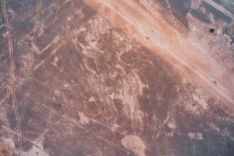
Huge spiral found in the Indian desert may be the largest drawing ever made
A huge spiral covering 100,000 square metres discovered in the Indian desert may be the largest drawing ever made, according to experts, who say it dwarfs the Nazca lines in South America.
The spiral artwork is made up of a series of small geoglyphs covering an area of about a million square feet in the Thar desert in India, first spotted on Google Earth by Carlo and Yohann Oetheimer, a father and son research team from France.
Nazca lines in Peru are a group of geoglyphs etched into a 380 sq mile area of desert sands dating back to at least 500 BCE, featuring figures of animals and plants.
While the South American geoglyphs are more plentiful, with up to 300 characters, and cover a larger area, a line in India is significantly larger than anyone Nazca line.
The lines make up four distinct symbols, created by scraping sand and silt near the village of Boha, with the largest single symbol 2,374ft long and 650ft wide, made of a single seven and a half mile line spiralling inwards.
Study authors, not affiliated with any institution, say the lines may be at least 150 years old, but can’t say anything more specific, adding their meaning is lost to history and they need to visit to study determine any dating.
Boha 3’s meandering lines.
Huge spirals discovered in the Indian desert may be the largest drawing ever made, according to experts, who say they dwarf the Nazca lines in South America
The duo searched through images on Google Earth showing the desert for unusual features. In the images they found eight possible sites, eventually discounting seven of them as being natural features.
The pair took a drone to the region in 2016 and flew it over the site.
During the drone flight, they found seven of eight predicted sites were actually just furrows dug for failed tree plantations. They found that the eighth site, near the village of Boha, had four distinct symbols, made up of 20 inch wide lines of varying length and complexity.
At the centre of the selection of geoglyphs is a symbol 2,374ft long and 650ft wide, made of a single seven and a half mile spiralling line.
South-west of this mega-spiral is a second line that repeatedly bends back on itself to form a grid of parallel lines, the team explained. There are also a pair of smaller geoglyphs to the north and south-west, but they are both heavily eroded.
Despite the work being carried out by independent, researchers, ‘the report is convincing,’ says Daniela Valenzuela from the University of Tarapaca in Chile.
The Nazca lines in Peru cover a wider area than the Thar lines, but the individual figures and lines are smaller, with the longest labyrinth line 2.7 miles long. The lines can’t be seen from the ground, according to the researchers, with Valenzuela saying ‘this may be significant.
Adding that it may imply that their significance came from the act of creation, not later viewing by future people.
The study authors wrote in their paper: ‘Three memorial stones positioned at key points, give evidence that planimetric knowledge has been used to create this elaborate design.’
Planimetric elements in geography are features independent of elevation – roads, rivers, lakes and buildings.
The lines make up four distinct symbols, created by scraping sand and silt near the village of Boha, with the largest single symbol 2,374ft long and 650ft wide, made of a single seven and a half mile line spiralling inwards
‘These artefacts allow us to envisage hypothetical modalities of edification,’ the authors wrote.
‘We collected indicators of antiquity suggesting that these lines may be at least 150 years old and possibly linked to the Hindu memorial stones surrounding them.
‘The lack of visibility from the ground raises the question of their function and meaning. So far, these geoglyphs, the largest discovered worldwide and for the first time in the Indian subcontinent, are also unique as regards their enigmatic signs.’
In the case of the Nazca line geoglyphs, they were likely created by people removing the black topsoil to reveal light-coloured sand hidden underneath. Geoglyphs span large land tracts located between the towns of Palpa and Nazca, and some depict animals, objects or compact shapes.
The spiral artwork is made up of a series of small geoglyphs covering an area of about a million square feet in the Thar desert in India, first spotted on Google Earth by Carlo and Yohann Oetheimer, a father and son research team from France
Aerial view of giant spiral (Boha 1) and Boha 2, including the serpent figure in lower-right corner.
Often, the composition of a geoglyph cannot be fully realised at ground level. Only when one is high enough in the air can they discern the shapes. For this reason, the intricacies of the designs were not fully realised until aeroplanes were invented and the artwork was seen from the sky.
‘We will need to go to India in the near future in order to complete our research and have a precise dating, in order to understand their function and meaning better. For now, the dating is hypothetical,’ Carlo Oetheimer told MailOnline.
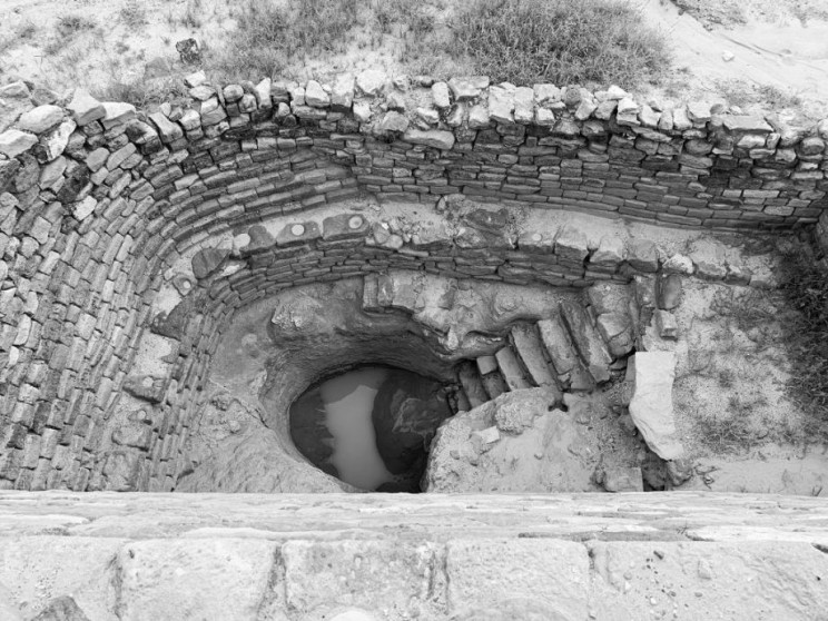
A 5,000-year-old stepwell has been found in one of the largest Harappan cities, Dholavira, in Kutch. It is part of a reservoir that is three times bigger than the Great Bath at Mohenjo Daro.
Located in the eastern reservoir of Dholavira by experts from the Archaeological Survey of India working with IIT-Gandhinagar, the site represents the largest, grandest, and the best furnished ancient reservoir discovered so far in the country.
It’s rectangular and approximately 241 ft. long, 96 ft. wide, and 31 ft. deep. Another site, the ornate Rani ki Vav in Patan, called the queen of step-wells, is already on Unesco list.
“We will conduct spot analysis in December as various surveys have indicated other reservoirs and step-wells may be buried in Dholavira,” V.N. Prabhakar told TOI.
“We also suspect a huge lake and an ancient shoreline are buried in the archaeological site that’s one of the five largest Harappan sites and the most prominent archaeological site in India belonging to the Indus Valley civilization,” he added.
Experts will investigate the advanced hydraulic engineering used by Harappans for building the stepwell through a 3D laser scanner, remote sensing technology and ground-penetrating radar system.
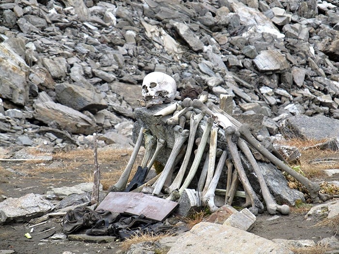
The view of an enormous pile of skulls and bones tangled under the water surface is quite enticing. You wonder who they are, and especially how they came here first because that lake is 16,000 feet above sea level and there is nothing more than ice tops and frozen glaciers around it.
The roopkund lake.
Every year, the ice melts and shows the human remains of more than 300 unfortunate people who rest at the bottom of the Roopkund, better known as the Skeleton Lake. This frozen, frozen, shallow lake is hidden deeper into the Indian Himalayas.
This “spectacular” view can be enjoyed in the core of the dark forest of Lohajung in Uttarakhand, India, by any enthusiastic trekking enthuse who wishes to walk down the steep path up to the glacier lake, which most of the moment is frozen, in a tiny valley elevated in the Garhwal section of the Himalayas.
Roopkund Lake contains hundreds of skeletons and is flanked by sheer cliffs.
The remains of an estimated 600-800 people have been found at the site
However, the ice begins to melt and the surface begins to see for a month when the temperature is sufficiently friendly. Then, the six-foot-deepest depth of the lake demonstrates what lies underneath the small and apparently typical natural wonders.
This is a death-ground filled with skeletons and not only that, but also the hair, nails, spears, knives, and gems, preserved by the frosts as if these souls had been decimated and found mysteriously their way into the bottom of this lake.
This stunning mystery has been tried by scientists, anthropologists, and historians to unravel. In 1942when the contents of the lake were first found by a British forest guard, Remains of unfortunate Japanese soldiers passing through the mountains were believed to be recent humans.
On the snow just outside the lake, the guard stumbled over a human skull, and on the basis of the preservation with a complete bunch of hair, it took on the most probable scenario. He submitted a report soon after finding more skeletons nearby and below the frozen lake surface.
And his hypotheses seemed logical at first. But there was no inquiry of the bones, and nobody knew who they were, what they were and what had occurred. So obviously, in moments of conflict, the authorities had the same initial conviction that these are the residues of a military battalion that passed through the hills in the direction of India.
But all these first impressions came down the drain after a more thorough inquiry when spears and all sorts of various old arms or bars were discovered lying next to the bones, and it was evident comprehensive research of the remains needed to be done.
The mystery had been unresolved for some moment and many theories were brought to life about what had occurred. People even accepted a local faith in an old goddess who would lay waste to a group of individuals who defied her.
The legend says that this goddess was so furious by the group of people who ostensibly passed by her unspoiled shrine in the mountains that she flung iron hailstones over these petty disrespectful people and killed them on the spot. The legend said she was so furious.
In recent studies, it has been found, in fact, that the skulls and their shoulders have clear signs of round-shape blows as if they had been struck from above. In 2004, the lake received samples and research from an expedition led by a team of Indian scientists with a few Europeans.
During the progress of DNA testing, the bones and some of the preserved human tissue could now be examined. The common belief was that the skeletons were the remains of people who over the years were killed by severe weather and sudden storms on the hills and slipped into the lake with snow, which prevented the natural process of decomposition.
Human skeletons at Roopkund Lake.
Although the bodies discovered that their height and body are distinguished, Almost all remains from the same time, at about 850 A.D., are found in the Radiocarbon Accelerator Unit of the University of Oxford, UK. In addition, two separate body types with similar DNA were found.
A group of smaller and thinner people and one completely the opposite. This resulted in them thinking it had to be a pilgrimage group or a kind of mountain excursion which hired local guides. Sadly, a baseball-style hail storm murdered them on their manner trapped in a valley and nowhere to find a shelter. That’s the recent scientific research at least.
One group of shorter individuals with smaller and thinner bones, and one completely the opposite. Which led them to believe that it must have been a group on pilgrimage or some kind of expedition in the mountains that hired some local guides. Unfortunately for them, trapped in a valley, and nowhere to be found with shelter, they were killed by a baseball-sized hail storm. This, at least, is based on recent scientific research.
According to the historical Himalayan legend of the ancient goddess, a king went on a pilgrimage in India to the Nanda Division Raj Jat Festival only once every 12 years, with his spouse, family, servants, musicians and others.
They hired locals to help them get there, but along the way, and despite locals telling them otherwise, the goddess Nanda Devi was angry and punished with their loudness. But most of all, a pregnant woman was in the group that presumably gave birth in the sacred land of the goddess. The newborn was the biggest sin of all and she had “hard-as-iron” sent out a storm of hailstones and murdered them.
This shrine in honor of Nanda Devi lies along the trail to Roopkund Lake.
Although it wasn’t the goddess ‘ wrath, it was certainly the fury of what killed hundreds of people. At least part of a legend clarified the mystery well before science. That means something completely distinct until more information and further research are revealed. This should be followed by a science or academic institution because sadly all trekking passers-by pick a bone or two as souvenirs, and very shortly there might be nothing left to be studied.
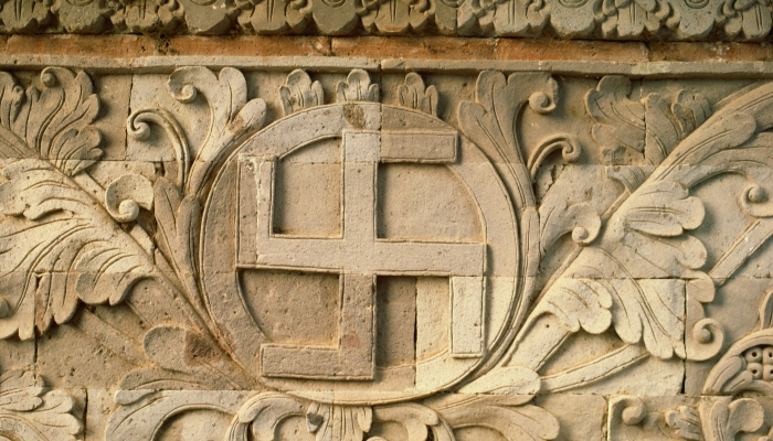
The Powerful Symbol of the Swastika and its 12,000 Year History
The swastika is a sign of the massacres of millions of people and the destructiveness of one of the most despised men on Earth. But it’s not Adolf Hitler who used the symbol first. It was actually utilized by many cultures and continents as a powerful symbol thousands of years before him.
The Swastika has been an important symbol for many thousands of years to the Hindus and Buddhists of India and other Asian countries, but the symbol is still visible in abundance – on temples, buses, taxis, and covers of books.
It was used in Ancient Greece as well and can be found in the ancient city of Troy that existed four thousand years ago.
A swastika is a symbol found in many cultures, with different meanings, drawn in different styles.
The ancient Druids and the Celts also used the symbol, reflected in many artefacts that have been discovered. It was used by Nordic tribes and even early Christians used the swastika as one of their symbols.
For example, the Teutonic Knights, a German medieval military order that became a purely religious Catholic order, used it. But why is this symbol so important and why did Adolf Hitler decide to use it?
The word “swastika” is a Sanskrit word (“svastika”) meaning “It is,” well being,” “good existence,” and “good luck.” However, it is also known by different names in different countries—like “wan” in China, “manji” in Japan, “fylfot” in England, “Hakenkreuz” in Germany and “tetraskelion” or “tetragammadion” in Greece.
Mosaic swastika in excavated Byzantine church in Shavei Tzion (Israel).
A Sanskrit scholar P.R. Sarkar in 1979 said that the deeper meaning of the word is “permanent victory.”
The earliest swastika ever found was uncovered in Mezine, Ukraine, carved on an ivory figurine, which dates an incredible 12,000 years, and one of the earliest cultures that are known to have used the swastika was a Neolithic culture in Southern Europe, in the area that is now Serbia, Croatia, Bosnia, and Herzegovina, known as the Vinca Culture, which dates back around 8,000 years.
In Buddhism, the swastika is a symbol of good fortune, prosperity, abundance, and eternity. It is directly related to Buddha and can be found carved on statues on the soles of his feet and on his heart. It is said that it contains Buddha’s mind.
Wooden Buddha statue with gamadian (swastika).
On the walls of the Christian catacombs in Rome, the symbol of the swastika appears next to the words “zotiko zotiko,” which means “life of life.” It can also be found on the window openings of the mysterious Lalibela Rock churches of Ethiopia, and in various other churches around the world.
In Nordic Myths, Odin is represented passing through space as a whirling disk or swastika looking down through all worlds. In North America, the swastika was used by the Navajos.
In Ancient Greece, Pythagoras used the swastika under the name “tetraktys,” and it was a symbol linking heaven and Earth, with the right arm pointing to heaven and the left arm pointing to Earth.
The swastika, the Phoenician sun symbol, on the Phoenician Craig-Narget stone in Scotland, and on the robe of a Phoenician high priestess.
It was used by the Phoenicians as a symbol of the sun and it was a sacred symbol used by the priestesses.
How and why did so many diverse countries and cultures, across many eras, use the same symbol and apparently with the same meaning? It is ironic, and unfortunate, that a symbol of life and eternity that was considered sacred for thousands of years has become a symbol of hatred.