Ancient Maya kingdom unearthed in a backyard in Mexico
A team of archeologists from the backyard of a rancher in Mexico have discovered the site of a long-lost ancient Mayan empire. The town was discovered with the help of a food vendor.
Since 1994, when references to it were discovered at inscriptions on other Mayan excavation sites, scientists have been searching for signs of the ancient Mayan kingdom of Sak Tz’i ‘. Apart from the reference, the kingdom is also mentioned in other sculptures.
It so happens that, in 2014, the University of Pennsylvania graduate student Whittaker Schroder was driving around Chiapas in southeastern Mexico when a man selling carnitas on the side of the highway informed him that a friend, a cattle rancher, had found an ancient stone tablet.
Upon confirming the authenticity of the tablet, Schroder and another graduate student from Harvard, Jeffrey Dobereiner, informed anthropology professor Charles Golden and Brown University bioarchaeologist Andrew Scherer of the find.
From that time, it took years before the team received permission to excavate on the property, with the team making sure that the government would not confiscate the rancher’s land.
This is because, in Mexico, cultural heritage such as Maya sites are considered the property of the state. So, the team worked with government officials to make sure that the rancher would get to keep his land.
The research team believes that the archaeological site unearthed in the rancher’s backyard, Lacanja Tzeltal, is actually the capital of the Sak Tz’i’ kingdom that was first settled in by 750 B.C.
At the site, the team found evidence of a marketplace where goods were sold, a 45-foot pyramid, as well as the ruins of several structures that likely served as the residence of the elites.
The team also found evidence of a ball court and a royal palace, as well as Maya monuments with important inscriptions. Dozens of sculptures were also recovered from the site, although most of them were already degraded. Ultimately, the best-preserved artifact from the site remains to be the tablet from the rancher.
Being a relatively modest kingdom compared to the others, Sak Tz’i’ was surrounded on all sides by more powerful states. This is evidenced by the walls that were possibly built to keep invaders out.
According to Golden, it is possible that mid-sized Sak Tz’i’ kingdom’s survival among the more powerful kingdoms depended not just on its military strength but also on making peace with its neighbors.
That said, little is still known about how the kingdom survived amid the hostilities they likely faced from other, more powerful kingdoms.
For now, the team is planning to go back to the site in June to stabilize the buildings that are in danger of collapsing well as to map the ancient city with modern tools and to look for more artifacts.
Left, drawing of a tablet found at the site. Right, a digital 3D model.
The study describing the find is published in the Journal of Field Archaeology.
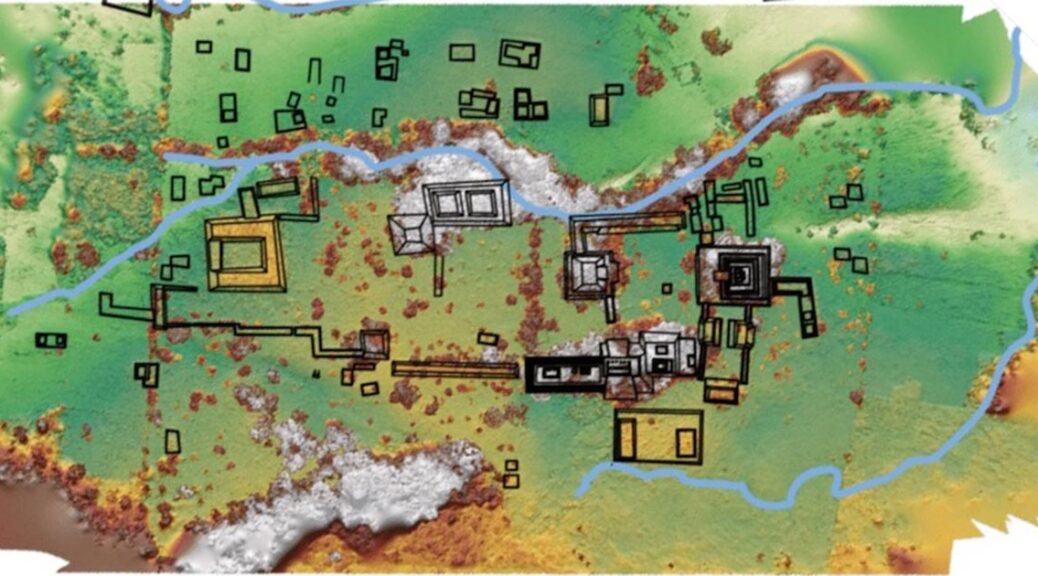
Mao of the Sak Tz’i’ kingdom excavation site in Mexico. The horseshoe-shaped building on the left is the palace area.
Mexican Government Returns Stolen Bronze Sculpture to Nigeria
Mexican customs officials thwarted an attempt to smuggle the ancient Yoruba sculpture into the country.
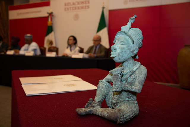
Mexico returns a smuggled bronze sculpture to Nigeria ?? after it was seized by customs officials at an airport. The Yoruba artefact is believed to date back to the 6th Century.
The Mexican government has recently returned a stolen bronze sculpture to Nigeria according to Vanguard.
The ancient sculpture was seized by customs officials at Mexico City Airport following an attempt to reportedly smuggle the artefact into the country.
The bronze sculpture itself is thought to be a 6th-century relic from the southwestern Yoruba City of Ife and depicts a man in woven pants sitting cross-legged and holding an instrument.
While it is still unclear how the artefact was obtained in the first place, Mexico’s Deputy Secretary of Foreign Affairs Julián Ventura Valero says, “We oppose the illegal commercialisation of archaeological pieces, an important cause of the impoverishment of the cultural heritage of the nations of origin, since it undermines the integrity of cultures and, therefore, of humanity.”
Several bronze artefacts ranging from a 19th-century cockerel from Benin City to an 18th-century Ethiopian crown have since been returned to their respective countries over the past few years.
Often the result of looting during the colonial era, the governments of these African countries are now rightly demanding that these stolen pieces of significant cultural history be permanently returned to them and not offered on “long-term loans” as has often been the case.
However, thousands more of these invaluable artefacts from many African countries remain housed in museums across Europe. Revisit our interview with anthropologist and curator Niama Safia Sandy about the politics around the repatriation of African art here.
Modern technology reveals old secrets about the great, white Maya road
Would one of the greatest cities of the ancient Mayan world, the mighty Queen of Cobá, create the longest Mayan road to invade a smaller, isolated neighbor and gain a foothold against the emerging Chichén Itzá empire?
Traci Ardren, a sociology professor at the University of Miami, has been fascinated by the problem for some time now. Now, she and fellow scholars may be a step closer to an answer, after conducting the first lidar study of the 100-kilometer stone highway that connected the ancient cities of Cobá and Yaxuná on the Yucatan Peninsula 13
Once used mainly by meteorologists to study clouds, lidar—short for “light detection and ranging”—technology is revolutionizing archaeology by enabling archaeologists to detect, measure, and map structures are hidden beneath dense vegetation that, in some cases, have grown for centuries, engulfing entire cities.
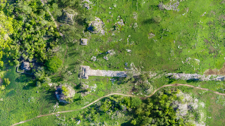
This lidar map of downtown Yaxuna reveals many ancient houses, platforms, palaces, and pyramids that are hidden by vegetation.
Often deployed from low-flying aircraft, lidar instruments fire rapid pulses of laser light at a surface and then measure the amount of time it takes for each pulse to bounce back. The differences in the times and wavelengths of the bounce are then used to create digital 3-D maps of hidden surface structures.
The lidar study, which Ardren and fellow researchers with the Proyecto de Interaccion del Centro de Yucatan (PIPCY) conducted in 2014 and 2017 of Sacbe 1—or White Road 1, as the white plaster-coated thoroughfare was called—may shed light on the intentions of Lady K’awiil Ajaw, the warrior queen who Ardren believes commissioned its construction at the turn of the 7th century.
In an analysis of the lidar study, recently published in the Journal of Archaeological Science, the researchers identified more than 8,000 tree-shrouded structures of varying sizes along the sacbe—with enough total volume to fill approximately 2,900 Olympic swimming pools.
The study also confirmed that the road, which measures about 26 feet across, is not a straight line, as has been assumed since Carnegie Institute of Washington archaeologists mapped its entire length in the 1930s, with little more than a measuring tape and a compass.
Rather, the elevated road veered to incorporate preexisting towns and cities between Cobá, which known for its carved monuments depicting bellicose rulers standing over bound captives, controlled the eastern Yucatan, and Yaxuná—a smaller, older, city in the middle of the peninsula. Yet, the isolated Yaxuná (pronounced Ya-shoo-na) still managed to build a pyramid nearly three times bigger and centuries before Chichén Itzá’s more famous Castillo, about 15 miles away.
A drawing of a carving found on a stone monument in Cobá depicts the warrior queen who may have built the great, white road to expand her domain.
“The lidar really allowed us to understand the road in much greater detail. It helped us identify many new towns and cities along the road—new to us, but preexisting the road,” Ardren said. “We also now know the road is not straight, which suggests that it was built to incorporate these preexisting settlements, and that has interesting geopolitical implications. This road was not just connecting Cobá and Yaxuná; it connected thousands of people who lived in the intermediary region.”
It was partly Yaxuná’s proximity to Chichén Itzá, Mexico’s most famous Maya ruin which flourished after Yaxuná and Cobá waned, that led Ardren and other PIPCY researchers to theorize that K’awiil Ajaw built the road to invade Yaxuná and gain a foothold in the middle of the peninsula. Coba’s ruler for several decades beginning in 640 A.D., she is depicted in stone carvings trampling over her bound captives.
“I personally think the rise of Chichén Itzá and its allies motivated the road,” Ardren said. “It was built just before 700, at the end of the Classic Period, when Cobá is making a big push to expand. It’s trying to hold on to its power, so with the rise of Chichén Itzá, it needed a stronghold in the center of the peninsula.
The road is one of the last-gasp efforts of Cobá to maintain its power. And we believe it may have been one of the accomplishments of K’awiil Ajaw, who is documented as having conducted wars of territorial expansion.”
To test their theory, Ardren, an expert on gender in ancient Maya society who edited the 2002 book “Ancient Maya Women,” and fellow PIPCY scholars received funding from the National Science Foundation to excavate ancient household clusters along the great white road.
Their goal is to determine the degree of similarities between the household goods in Cobá and Yaxuná before and after the road was built. The thinking, Ardren said, is that after the road linking the two cities, the goods found in Yaxuná would show increasing similarities to Cobá’s.
So far, the researchers have excavated household clusters on the edge of both Cobá and Yaxuná, and they plan to begin the third dig this summer, at a spot informed by the lidar study. It sits between the two ancient Maya cities, on the great, white road that Ardren says would have glowed brightly even in the dark of night.
As she noted, the road was as much an engineering marvel as the monumental pyramids the Maya erected across southern Mexico, Guatemala, northern Belize, and western Honduras.
Although built over undulating terrain, the road was flat, with the uneven ground filled in with huge limestone boulders, and the surface coated with bright, white plaster. Essentially the same formula the Romans used for concrete in the third century B.C., the plaster was made by burning limestone and adding lime and water to the mixture.
“It would have been a beacon through the dense green of cornfields and fruit trees,” Ardren said. “All the jungle we see today wasn’t there in the past because the Maya cleared these areas. They needed wood to build their homes. And now that we know the area was densely occupied, we know they needed a lot of wood. Because they also needed it to burn limestone”—and build the longest road in the Maya world 13 centuries ago.
Mexico earthquake reveals lost ancient temple inside the pyramid
The remains of the great pyramid of Teopanzolco have long offered visitors to the southern Mexican site unique insights into the structure’s inner workings while simultaneously conjuring visions of the intricate temples that once arose from its series of bases and platforms.
Today, remnants of twin temples—to the north, a blue one dedicated to the Aztec rain god Tláloc, and to the south, a red one dedicated to the Aztec sun god Huitzilopochtli—still top the pyramid’s central platform, joined by parallel staircases.
Although archaeologists have intermittently excavated the Teopanzolco site since 1921, it took a deadly 7.1 magnitude earthquake to unveil one of the pyramid’s oldest secrets: an ancient shrine buried about six-and-a-half feet below Tláloc’s main temple.
According to BBC News, scientists from Mexico’s National Institute of Anthropology and History (INAH) discovered the temple while scanning the pyramid for structural issues.
The earthquake, which struck central Mexico on September 19, 2017, caused “considerable rearrangement of the core of [the pyramid’s] structure,” INAH archaeologist Bárbara Konieczna said in a statement.
For local news outlet El Sol de Cuernavaca, Susana Paredes reports that some of the most serious damage occurred in the upper part of the pyramid, where the twin temples are located; the floors of both structures had sunk and bent, leaving them dangerously destabilized.
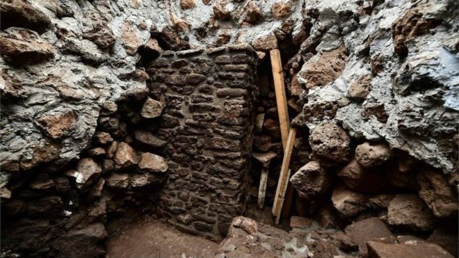
The discovery was made at the Teopanzolco pyramid in Cuernavaca
To begin recovery efforts, archaeologists created wells in the temple dedicated to Tláloc and a corridor separating the two temples.
During this work, the team unearthed a previously unknown structure, which featured a similar architectural style—double facade walls covered in elongated stones and stucco-encased slabs—to that of the existing Tláloc temple.
In the statement, Konieczna notes that the temple would have measured about 20 feet by 13 feet and was probably dedicated to Tláloc, just like the one located above it. It’s possible that a matching temple dedicated to Huitzilopochtli lies on the opposite side of the newly located one, buried by later civilizations’ architectural projects.
The humidity of the Morelos region had damaged the temple’s stucco walls, according to a press release, but archaeologists were able to save some of the remaining fragments.
Below the shrine’s stuccoed floors, they found a base of tezontle, a reddish volcanic rock widely used in Mexican construction, and a thin layer of charcoal. Within the structure, archaeologists also discovered shards of ceramic and an incense burner.
Paredes of El Sol de Cuernavaca notes that the temple likely dates to about 1150 to 1200 C.E. Comparatively, the main structure of the pyramid dates to between 1200 and 1521, indicating that later populations built over the older structures.
The Teopanzolco site originated with the Tlahuica civilization, which founded the city of Cuauhnahuac (today is known as Cuernavaca) around 1200, as G. William Hood chronicles for Viva Cuernavaca. During the 15th century, the Tlahuica people were conquered by the Aztecs, who, in turn, took over the construction of the Teopanzolco pyramids.
Following the 16th-century arrival of the Spanish conquistadors, the project was abandoned, leaving the site untouched until its 1910 rediscovery by Emiliano Zapata’s revolutionary forces.
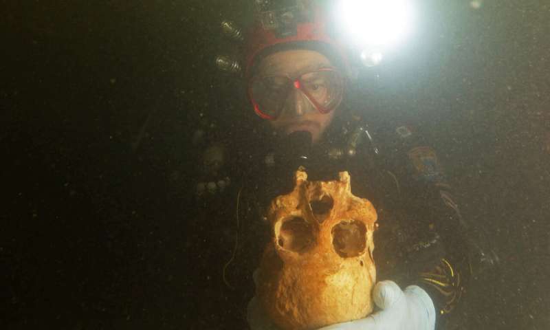
9,900-year-old Mexican female skeleton distinct from other early Native American settlers
According to a research published at PLOS ONE on the 5th February 2020 by Wolfgang Stinnesbeck of the University of Heidelberg, the new skeleton discovered in the submerged caves of Tulum sheds light on the earliest settlers in Mexico.
Underwater exploration of Chan Hol Cave, near Tulum, Mexico. Credit: Eugenio Acevez.
Humans have been living in Mexico’s Yucatán Peninsula since at least the Late Pleistocene (126,000-11,700 years ago).
We also discovered much of the earliest Mexican settlers from nine well-preserved human skeletons found in the submerged caves and sinkholes near Tulum in Quintana Roo, Mexico.
Here, Stinnesbeck and colleagues describe a new, 30 percent-complete skeleton, ‘Chan Hol 3’, found in the Chan Hol underwater cave within the Tulum cave system.
The authors used a non-damaging dating method and took craniometric measurements, then compared her skull to 452 skulls from across North, Central, and South America as well as other skulls found in the Tulum caves.
The analysis showed Chan Hol 3 was likely a woman, approximately 30 years old at her time of death, and lived at least 9,900 years ago.
Her skull falls into a mesocephalic pattern (neither especially broad or narrow, with broad cheekbones and a flat forehead), like the three other skulls from the Tulum caves used for comparison; all Tulum cave skulls also had tooth caries, potentially indicating a higher-sugar diet.
This contrasts with most of the other known American crania in a similar age range, which tend to be long and narrow, and show worn teeth (suggesting hard foods in their diet) without cavities.
Though limited by the relative lack of archeological evidence for early settlers across the Americas, the authors suggest that these cranial patterns suggest the presence of at least two morphologically different human groups living separately in Mexico during this shift from the Pleistocene to the Holocene (our current epoch).
The authors add: “The Tulúm skeletons indicate that either more than one group of people reached the American continent first, or that there was enough time for a small group of early settlers who lived isolated on the Yucatán peninsula to develop a different skull morphology.
The early settlement history of America thus seems to be more complex and, moreover, to have occurred at an earlier time than previously assumed.”
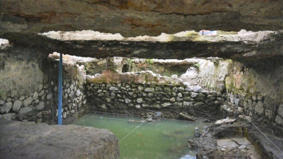
Native American 14th-century’ sweat lodge’ discovered in Mexico City
Archaeologists in Mexico City’s ancient La Merced district have unearthed a pre-Hispanic mesoamerican sauna from the 14th century.
The BBC reports that several primary sections of the ancient sweat lodge still exist remarkably intact.
The Mesoamericans of the period built these ancestral saunas, known as temazcals, for medicinal, spiritual, and fertility purposes and rituals. Mexico’s National Institute of Anthropology and History (NIAH) said the find clarified a slew of historical questions.
Unearthing the pre-Hispanic site helped experts locate Temazcaltitlán — one of the very first settled areas of the ancient city of Tenochtitlán. The site was primarily used for purification ceremonies for the ill, for warriors after a battle, and for ensuring successful childbirth.
A foundation house and a colonial tannery were found at the site, as well.
Alongside practical purification purposes, these saunas served as a place to recover after the battle, prepare for childbirth, and worship goddesses of lust, vice, land, water, and more.
Researchers believe Mexica nobles — the Mexica were the indigenous people of the Valley of Mexico who comprised the Aztec Empire between 1428 and 1521 — lived in the former between 1521 and 1620, while the tannery is currently dated to between 1720 and 1820.
For excavation lead Víctor Esperón Calleja, these discoveries have shed enormous light on the region’s history and culture.
“Tenochtitlán was divided into four parts and we are in the part called Teopan in a neighborhood called Temazcaltitlán where the sweat lodges were,” he said. “The [house and tannery] findings suggest that in the 16th century this area was more populated than we initially thought.”
The foundations of a house and a tannery were discovered at the site, as well. Experts believe a noble family lived in the home after Hernán Cortés conquered the city of Tenochtitlán from Moctezuma II in 1521.
The house, built after the Spanish conquistador Hernán Cortés took the Aztec city of Tenochtitlán and defeated Moctezuma II in 1521, was decorated with red motifs on the interior walls.
Researchers believe its owners were a noble and respected family. Tenochtitlán was, after all, a major metropolis home to a wide stratum of social and economic classes in Aztec society.
“The site is part of a protected area and that is why Archaeological Rescue Office of the INAH has intervened,” said Calleja in reference to the INAH taking the lead on this discovery.
Many of the sauna’s main components, such as the pits themselves, have remained intact for centuries.
In terms of the temazcal’s size, INAH confirmed the foundation is 16.4 feet long and 9.7 feet wide. A bathtub and a bench were built into its walls, the discovery of which lends credence to another known historical record.
An Aztec record says that a Mexica noblewoman named Quetzalmoyahuatzin regularly bathed in a temazcal before giving birth. Now that a sweat lodge like the one described in this record has actually been discovered, that written document is largely verified as fact.
Researchers believe the whole neighborhood was one centered on worship, and not just of Tlazolteotl — the Aztec deity dedicated to purification, steam baths, lust, and vice.
Lead excavator on the project Víctor Esperón Calleja explained that the Archaeological Rescue Office of the INAH took over because the site is located in a historically protected area.
Other deities such as Ixcuina, the goddess of labor, Ayopechtli, the goddess of birth itself, and goddesses who represented land or water — such as Coatlicue, Toci, Chalchiuhtlicue, and Mayahuel — were honored there, too.
As it stands, there may be further revelations stemming from this discovery that’ll contextualize this history even more.
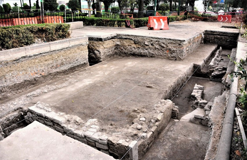
Archeologists in the Mexico City district of Azcapotzalco have discovered the base of the pre-Hispanic house and other building remnants of an ancient settlement.
In a declaration, the INAH confirmed that the finds in the historic center of the northern borough were part of the ancient altépetl, or city-state, of Mexicapan.
The city came into being when inhabitants of the Aztec or Mexica, capital of Tenochtitlán conquered the dominion of Azcapotzalco in 1428 and divided it into two autonomous settlements – Mexicapan and Tepanecapan.
The “domestic platform,” as INAH describes the foundations of the home, and the other structural remains are believed to have been part of a residential neighborhood within Mexicapan that was occupied by the city’s elite.
Measuring eight meters by six meters, the stone foundations of the pre-Hispanic house are among the largest ever found in Azcapotzalco, said INAH archaeologist Nancy Domínguez Rosas. The archaeological rescue team she heads also unearthed the remains of stone walls on the perimeter of the platform that measures between 50 and 70 centimeters.
The discovery is located in the historic center of Azcapotzalco.
The foundation is well preserved, Domínguez said, although the wall remains show signs of damage from more recent construction.
Archaeologists believe that the platform was built in two separate stages, the first of which corresponds to the late post-classic period between 1350 and 1519 AD. When the second phase of construction took place has not yet been determined.
Archaeologists found the platform while working alongside a municipal government team that was installing a tension fabric structure on Paseo de las Hormigas (Promenade of the Ants), which is part of the Azcapotzalco Park.
Domínguez said that 31 holes between one and two meters deep were dug for the slab foundations of the shade structure.
The structural remains of the Mexicapan neighborhood were discovered at a depth of 1.2 to two meters in front of the Azcapotzalco market, she said.
In addition to the domestic platform, archaeologists discovered the remains of other residential structures including one that measures 1.72 by 1.75 meters. All of the structures were made out of high-quality materials, leading archaeologists to conclude that they housed the elite and upper classes of Mexicapan society.
The archaeological rescue team has also discovered artifacts made out of both stone and bones.
Domínguez said the presence of the INAH team while the municipal employees are working in the area ensures that archaeological remains are not damaged, adding that archaeologists will continue to work to determine if there are any more pre-Hispanic structures in the area.
After they have been examined, the structures will be covered with geotextile, soil, and limestone to avoid their deterioration.
The discovery of such remains allows archaeologists “to recover information and contrast it with the information provided by historical sources,” Domínguez said, adding that the aim is to develop a greater understanding of “the way of life” of the residents of Mexicapan.
She also said that there is evidence that there were chinampas, or floating gardens, in the elite neighborhood and that human burials took place there.
The information . . . helps us to gradually reconstruct the puzzle of the urban configuration of Azcapotzalco in the pre-Hispanic era,” Domínguez said.
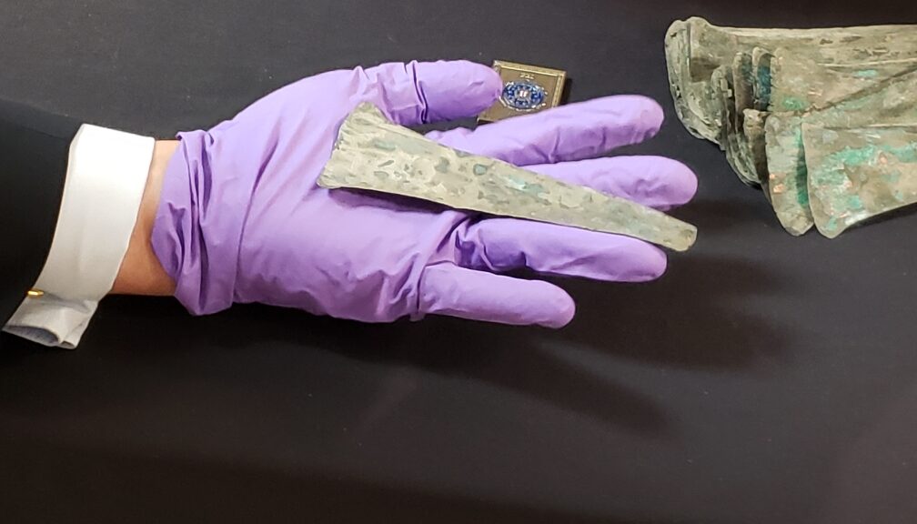
More Than 3,500 Copper Coins Repatriated to Mexico
3,500 tongue-like copper coins were handed over to Mexican authorities in the United States. Mexico daily news Reported.
One of the copper coins being returned to Mexico.
The Mexican Consulate Jessica Cascante in Miami said the coins are thought to have been used in what are now the southwestern Mexican states of Guerrero and Michoacán between A.D. 1200 and 1500.
The United States returned a collection of over 3,500 pre-Hispanic copper coins to Mexican authorities in a ceremony in Miami on Monday.
A U.S. collector acquired them in Texas at a numismatic fair in the 1960s, she said, but at that time neither Mexico nor the United States was part of a UNESCO convention that guarantees the return of such heritage artifacts to their countries of origin.
Cascante said the fragile, tongue-shaped coins, which are currently covered in verdigris, will be sent to Mexico in January.
Agents of the U.S. Federal Bureau of Investigations (FBI) who headed the operation to recover the coins attended the presentation ceremony along with the Consul General of Mexico in Miami, Jonathan Chait.
The collection consists of over 3,500 coins.
Mexican authorities notified the FBI of the existence of the coins in 2013 when they were taken to Spain for an auction.
Mexico’s National Institute of Anthropology and History (INAH) then began authenticating the coins in order to request their return.
As both countries were by then signatories to the UNESCO convention (Mexico in 1972 and the United States in 1983), the return process was completed six years later.
Cascante did not divulge the name of the collector who obtained the coins in the 1960s, but said that he did so before it constituted a crime and turned them involuntarily.
“Now we’re just waiting for the physical material to arrive [in Mexico],” she said, adding that they are currently being packaged with the support of specialists from history museums in Florida.