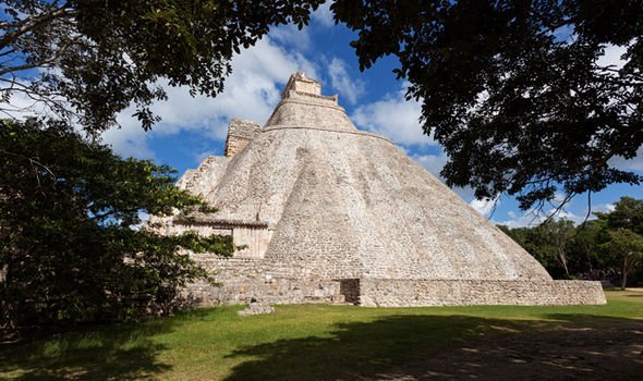
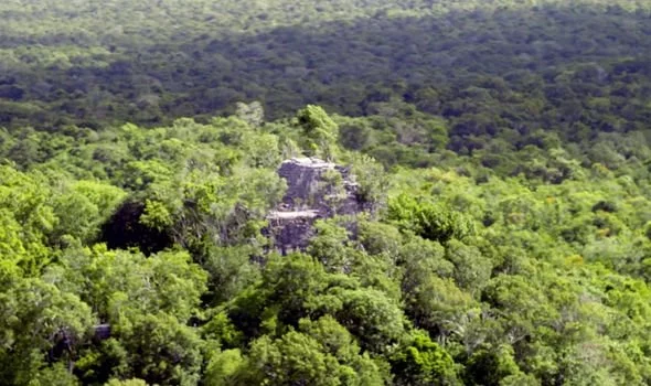
The Mayans were a civilisation known for their architecture, mathematics and astronomical beliefs, who date back to as far as 2000BC. Many of their impressive constructions can still be seen in the jungles of southeast Mexico, Guatemala, Belize and western parts of Honduras.
Even to this day, archaeologists are constantly battling against local looters to get their hands on some of the most exquisite finds to learn more about this advanced society.
However, there is one discovery that has topped them all over the years, it was revealed during Amazon Prime’s “Mayan treasure hunters” series.
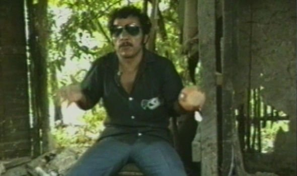
The 1990 documentary featured an interview with a Guatemalan criminal who told a tale of a “priceless find”.
The man, who did not reveal his name, detailed: “Picking sapodilla leaves [to make chewing gum] is the only job that pays money out here – at least eight or nine dollars a day.
“You compare that with finding a good piece, maybe worth $20,000 (£15,560) – that’s a fortune and you could live happily forever.
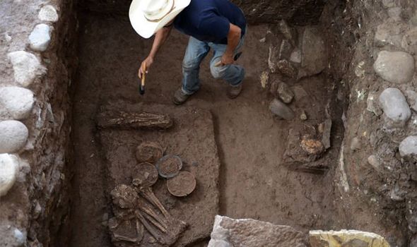
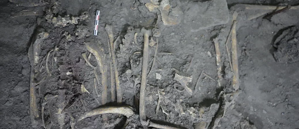
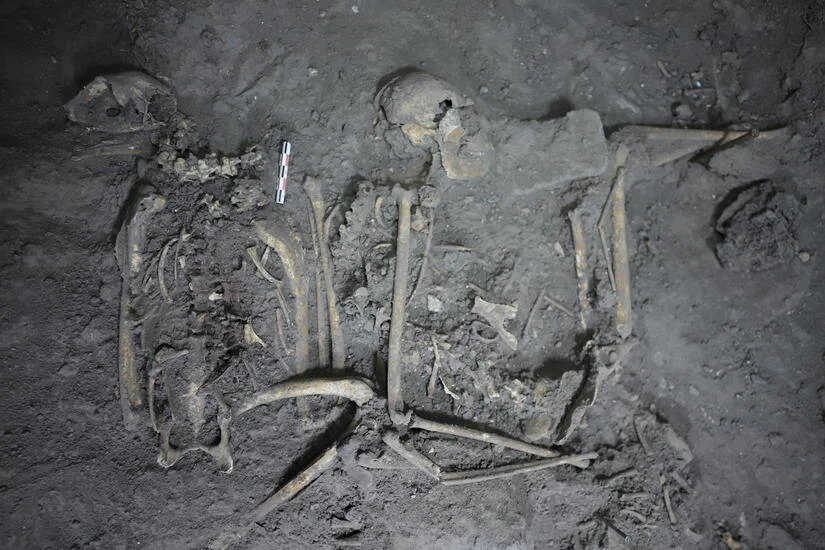
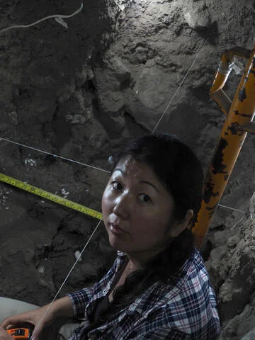
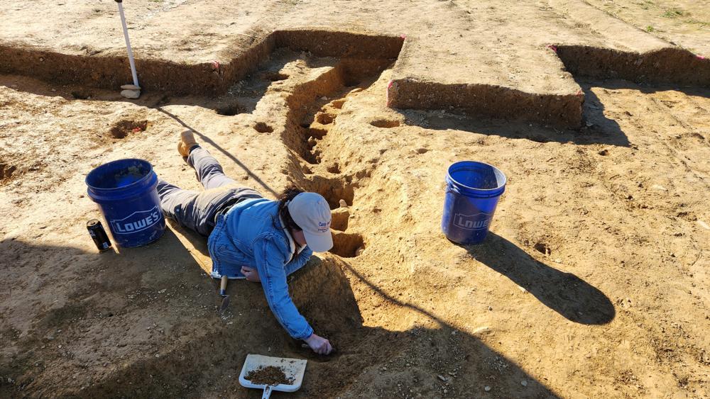
A skeleton discovered during a temple excavation
Mayan temples are still being discovered today
The price? You couldn’t say – priceless – it would be in the millions
Local looter
“Eight years ago a find was sold for $90,000 (£70,000).
“And before that, an archaeologist at the site of El Mirador took away a human skeleton made of jade – the whole skeleton was intact.
“The price? You couldn’t say – priceless – it would be in the millions”.
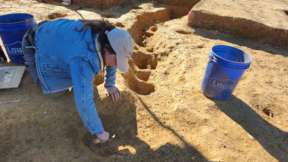
Archaeologists are constantly battling against local looters in a bid to salvage any remains left behind by this intriguing civilisation.
A 36-year-long Guatemalan Civil War, which ended in 1996, left more than 200,000 people dead and half a million driven from their homes in the jungle.
A local looter says one skeleton was discovered intact
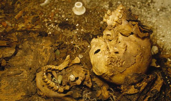
Skeleton remains were discovered previously.
The genocide against the Mayan people largely took place during the reign of Efraín Ríos Montt.
The Guatemalan President instituted a campaign of state terror intended to destroy the Mayans in the name of countering “communist subversion” and ridding the country of its culture.
Also known as Operation Sofia, the military followed through with “scorched earth policies” which allowed them to destroy whole villages, including killing livestock, destroying cultural symbols, destroying crops, and murdering civilians.
In some areas, government forces killed about 40% of the total population as the campaign destroyed at least 626 Mayan villages.
Now looters try to get their hands on ancient artefacts left behind that can be sold to American buyers.
Mayan DISCOVERY: How find in 2,000-year-old city ‘reveals story of creation’
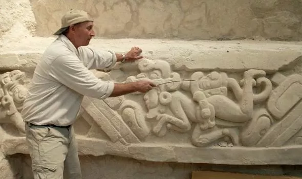
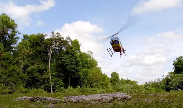
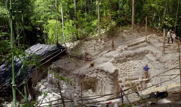
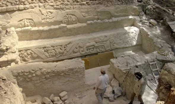
The Mayans were a civilisation known for their architecture, mathematics and astronomical beliefs, who date back as far as 2000BC. However, thanks to a discovery made at the El Mirador site in northern Guatemala, historians are able to know more about their theories over how human beings ended up on Earth. Archaeologist Richard Hansen took Morgan Freeman to see a spectacular discovery deep in the jungles during the filming of “The Story of God”.
He told Mr Freeman in 2017: “We like to think of Los Angeles and New York as being modern cities, but these guys had the same perspective of their own city.
“They had water delivery systems. they had freeways – the very first in the world.
“This is one of the most interesting excavations we have ever had.
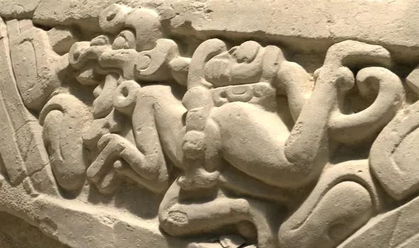
“This is art that was carved in stucco hundreds of years before Christ and it has an incredible scene showing the entire pantheon of the Mayan religion.
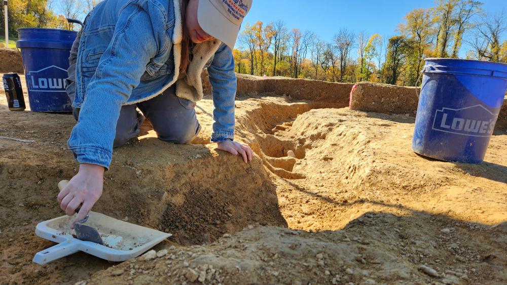
Richard Hansen pointed out the strange artwork
The team travelled deep into the jungles
This is one of the most interesting excavations we have ever had
Richard Hansen
“This is the Mayan Bible, the Mayan Genesis story with all the deities that are needed to tell the story.”
Mr Hansen went on to reveal what he believed the stonework represented.
He added: “This is the oldest version of the Mayan’s sacred story of creation that has ever been found.
“The focus is on two swimmers carrying a severed head.
“It’s this head right here that gave us the clue who this might be a the first place.
They visited El Mirador site in Northern Guatemala
The site is home to ancient Mayan structures
“We think this is Hunahpu – one of the hero twins that serves the whole process of creation.”
The Mayan Hero Twins are the central figures of the oldest Mayan myth to have been preserved in its entirety. Hunahpu and Xbalanque are portrayed as complementary forces – life and death, sky and Earth or day and night. The pair need each other to balance out the other and balance out the two sides of a single entity. It comes after another discovery was revealed when the truth was over when the Mayans thought the world would end.
The team uncovered inscriptions
In 2012, there was a brief frenzy after it was claimed that December 21 would mark the end of the world because it was the end-date of a 5,126-year cycle on the Mayan calendar. However, thanks to the discovery of a stone slate in Tikal, Guatemala, archaeologists are able to understand more about this key date. Stanley Guenter, a world-leading decoder of Mayan inscriptions, revealed during the same series: “This is stela 10, you can see we’ve got a king – there is his head and big headdress full of feathers, [his] shoulders, all of his jewellery and down to his feet.
“If you look down below, we can actually see we have a captive and we can see his hands and even legs – all tied up for sacrifice.
“[On the back] we have a date that gives us a specific point in time – 11 years and 360 days, then we have three katuns – which are 20 years each.
“So that is another 60, and then we have nine b’ak’tuns, because this is a date of about 525AD.
“So if you remember we had 13 b’ak’tuns ended in 2012, but the really interesting thing is the monument does not stop there.”
Mr Guenter then went on to reveal how the entirety of the discovery reveals the 2012 prediction was just a single cycle inside a number of bigger cycles.
Archaeologists believe it is one of the Mayan Heroes Twins
He continued: “It tells us there were 19 of the higher unit – the pictun – and even higher, 11 at the next unit.
“Each one of those units is 20 times larger than the previous, so what we see on this monument is that 13 b’ak’tuns was not the end of any calendar – just one cycle.
“It was just the start of a new cycle, a new beginning, that would go on for almost eternity.
Spider Monkey at Teotihuacan May Have Been a Maya Gift
The complete skeletal remains of a spider monkey — seen as an exotic curiosity in pre-Hispanic Mexico — grants researchers new evidence regarding social-political ties between two ancient powerhouses: Teotihuacán and Maya Indigenous rulers.
The discovery was made by Nawa Sugiyama, a UC Riverside anthropological archaeologist, and a team of archaeologists and anthropologists who since 2015 have been excavating at Plaza of Columns Complex, in Teotihuacán, Mexico.
The remains of other animals were also discovered, as well as thousands of Maya-style mural fragments and over 14,000 ceramic sherds from a grand feast. These pieces are more than 1,700 years old.
The spider monkey is the earliest evidence of primate captivity, translocation, and gift diplomacy between Teotihuacán and the Maya.
Details of the discovery will be published in the journal PNAS. This finding allows researchers to piece evidence of high diplomacy interactions and debunks previous beliefs that Maya presence in Teotihuacán was restricted to migrant communities, said Sugiyama, who led the research.
The complete 1,700-year-old skeletal remains of a female spider monkey were found in Teotihuacán, Mexico.
“Teotihuacán attracted people from all over, it was a place where people came to exchange goods, property, and ideas. It was a place of innovation,” said Sugiyama, who is collaborating with other researchers, including Professor Saburo Sugiyama, co-director of the project and a professor at Arizona State University, and Courtney A.
Hofman, a molecular anthropologist with the University of Oklahoma. “Finding the spider monkey has allowed us to discover reassigned connections between Teotihuacán and Maya leaders.
The spider monkey brought to life this dynamic space, depicted in the mural art. It’s exciting to reconstruct this live history.”
Researchers applied a multimethod archaeometric (zooarchaeology, isotopes, ancient DNA, palaeobotany, and radiocarbon dating) approach to detail the life of this female spider monkey. The animal was likely between 5 and 8 years old at the time of death.
Its skeletal remains were found alongside a golden eagle and several rattlesnakes, surrounded by unique artefacts, such as fine greenstone figurines made of jade from the Motagua Valley in Guatemala, copious shell/snail artefacts, and lavish obsidian goods such as blades and projectiles points.
This is consistent with the evidence of the live sacrifice of symbolically potent animals participating in state rituals observed in Moon and Sun Pyramid dedicatory caches, researchers stated in the paper.
Nawa Sugiyama, a UC Riverside anthropological archaeologist, at work in Teotihuacán, Mexico.
Results from the examination of two teeth, the upper and lower canines, indicate the spider monkey in Teotihuacán ate maize and chilli peppers, among other food items. The bone chemistry, which offers insight into the diet and environmental information, indicates at least two years of captivity. Prior to arriving in Teotihuacán, it lived in a humid environment, eating primarily plants and roots.
The research is primarily funded by grants awarded to Sugiyama from the National Science Foundation and National Endowment for the Humanities. Teotihuacán is a pre-Hispanic city recognized as a UNESCO World Heritage site and receives more than three million visitors annually.
In addition to studying ancient rituals and uncovering pieces of history, the finding allows for a reconstruction of greater narratives, of understanding how these powerful, advanced societies dealt with social and political stressors that very much reflect today’s world, Sugiyama said.
“This helps us understand principles of diplomacy, to understand how urbanism developed … and how it failed,” Sugiyama said. “Teotihuacán was a successful system for over 500 years, understanding past resilience, its strengths and weaknesses are relevant in today’s society. There are many similarities between then and now. Lessons can be seen and modelled from past societies; they provide us with cues as we go forward.”
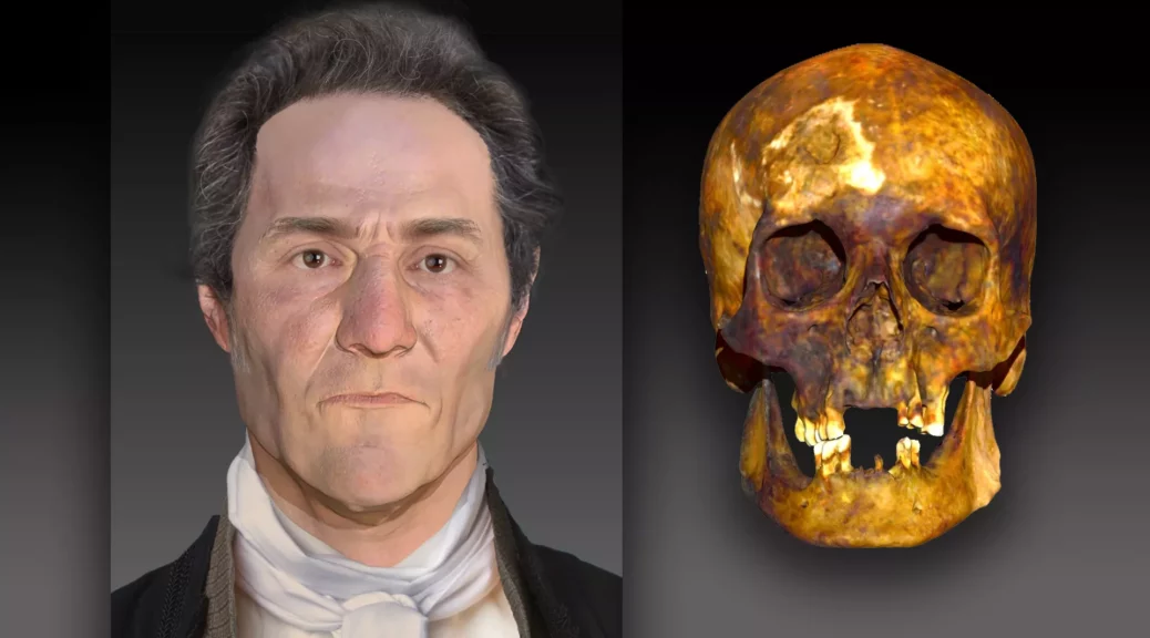
See the face of an 18th century ‘vampire’ buried in Connecticut
Using DNA extracted from a skull, a forensic artist created a facial reconstruction of a man believed to be a vampire from the 18th century.
In the late 18th century, a man was buried in Griswold, Connecticut, with his femur bones arranged in a criss-cross manner — a placement indicating that locals thought he was a vampire. However, little else was known about him.
More than 200 years later, DNA evidence is revealing what he may have looked like. (And yes, he was genetically human.)
After performing DNA analyses, forensic scientists from a Virginia-based DNA technology company named Parabon NanoLabs, and the Armed Forces DNA Identification Laboratory (AFDIL), a branch of the U.S. Armed Forces Medical Examiner System based in Delaware, concluded that at the time of death, the deceased male (known as JB55) was about 55 years old and suffered from tuberculosis.
Using 3D facial reconstruction software, a forensic artist determined that JB55 likely had fair skin, brown or hazel eyes, brown or black hair and some freckles, according to a statement.
Based on the positioning of the legs and skull in the grave, researchers suspect that at some point the body was disinterred and reburied, a practice often associated with the belief that someone was a vampire. Historically, some people once thought that those who died of tuberculosis were actually vampires, according to the statement.
“The remains were found with the femur bones removed and crossed over the chest,” Ellen Greytak, director of bioinformatics at Parabon NanoLabs and the technical lead for the organization’s Snapshot Advanced DNA Analysis division, told Live Science. “This way they wouldn’t be able to walk around and attack the living.”
To perform the analyses, forensic scientists began by extracting DNA from the man’s skeletal remains. However, working with bones that were more than two centuries old proved challenging.
“The technology doesn’t work well with bones, especially if those bones are historical,” Greytak said. “When bones become old, they break down and fragment over time. Also, when remains have been sitting in the environment for hundreds of years, the DNA from the environment from things like bacteria and fungi also end up in the sample. We wanted to show that we could still extract DNA from difficult historical samples.”
A common practice was to bury suspected vampires with their legs crossed so that way they couldn’t rise from the dead.
In traditional genome sequencing, researchers strive to sequence each piece of the human genome 30 times, which is known as “30X coverage.” In the case of the decomposed remains of JB55, the sequencing only yielded about 2.5X coverage.
To supplement this, researchers extracted DNA from an individual buried nearby who was believed to be a relative of JB55. Those samples yielded even poorer coverage: approximately 0.68X.
“We did determine that they were third-degree relatives or first cousins,” Greytak said.
Archaeologists originally unearthed the supposed vampire’s remains in 1990.
In 2019, forensic scientists extracted his DNA and ran it through an online genealogical database, determining that JB55 was actually a man named John Barber, a poor farmer who likely died of tuberculosis.
The nickname JB55 was based on the epitaph spelled out on his coffin in brass tacks, denoting his initials and age at death.
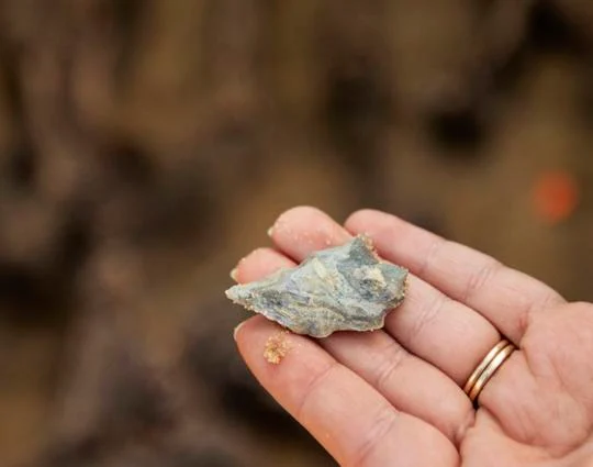
Revolutionary War–Era Graves Unearthed in South Carolina
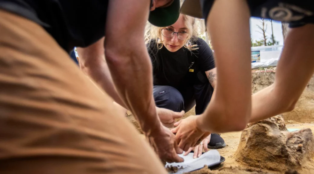
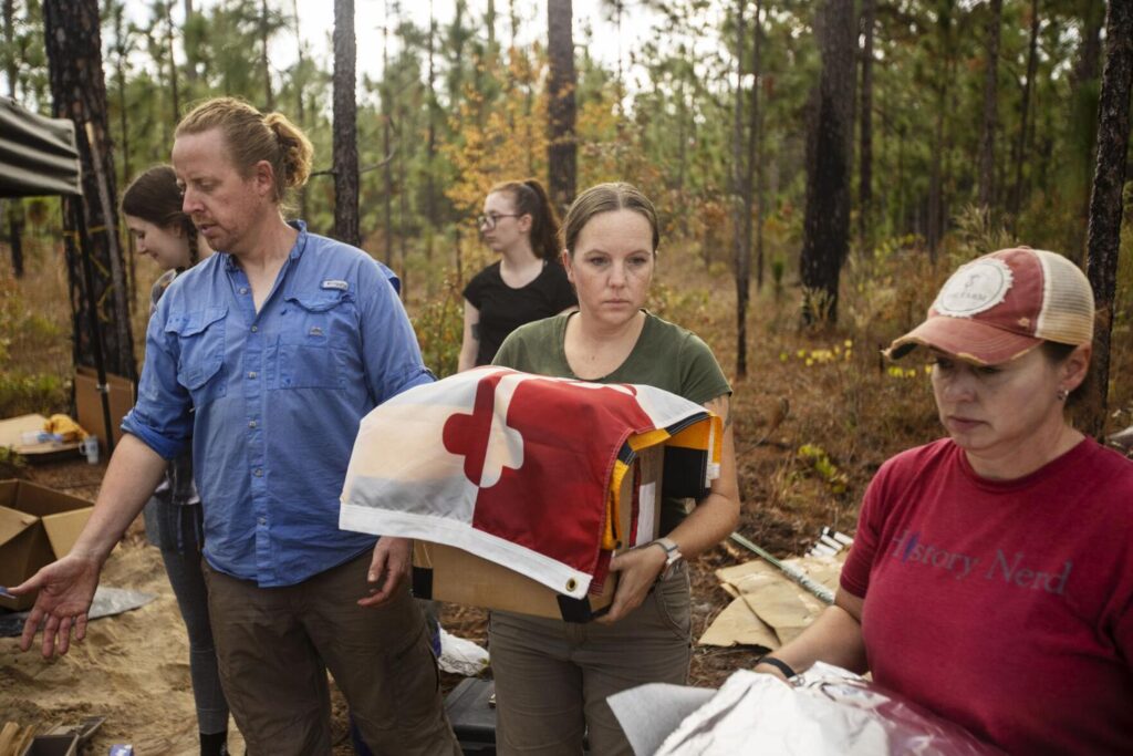
Bill Stevens (from left), Rachel Baker and Madeline Atwell, all forensic anthropologists with the Richland County Coroner’s Office, carefully remove skeletal remains on Nov. 4, 2022, from a gravesite located where the Battle of Camden was fought between American Patriots and the British. Gavin McIntyre/Staff
The bones came out, one by one, lifted from the earth by experienced hands, wrapped in foil and labelled, until the entire skeleton was liberated from this shallow gravesite. The coroners laid each package in a box. Someone unfurled a Maryland flag. Doug Bostick, executive director of the South Carolina Battleground Preservation Trust, offered words of thanks to the team.
“It’s so surreal,” he said of the find, “and real.”
Then his colleague David Reuwer voiced a loud cheer.
“Hip-hip …” he called.
“Hoozah!” came the collective response.
“Hip-hip …”
“Hoozah!”
“And for them, hip-hip …”
“HOOZAH!”
The box containing the remains of this Continental Army fighter from Maryland was carried slowly, in procession, to a nearby car as everyone gathered on this old battlefield stood respectfully, hand upon their chest.
Sara Rogers, with the South Carolina Institute of Archaeology and Anthropology, holds a box with the remains of a Revolutionary War soldier found at the site of the Battle of Camden. A Maryland state flag is draped over the box in honor of the fighter’s origins. Gavin McIntyre/Staff
The soldier, one of 14 discovered here in recent months, surely died a miserable death. His bones, and the skeletal remains of four others hastily buried next to him, were reminders of war’s terrible violence and time’s indifference.
These young men had been lost to the sandy soil, their determination in the face of an overpowering enemy largely forgotten. The battle is known, but not the individual fighters — men of the 1st and 2nd Maryland Brigades, the Delaware Continental Army, Armand’s Legion, and Virginia and North Carolina militias. This archaeological and forensic work changes that. The human remains, tattered though they are, will go to the lab of University of South Carolina anthropology professor Carlina Maria de la Cova for extensive analysis that surely will reveal new information about the Battle of Camden, a disaster for Continental Army Maj. Gen. Horatio Gates and the men under his command on that hot summer day of Aug. 16, 1780.
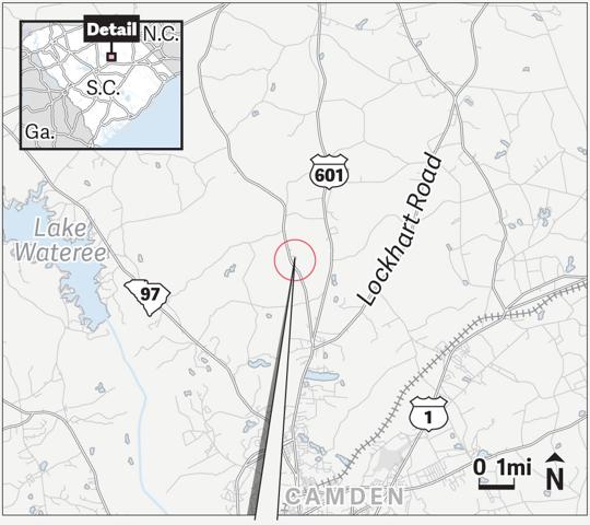
CAMDEN BATTLEFIELD: The Battle of Camden, fought on a hot summer day in 1780, was a major defeat for the Continental Army. An archaeological project has turned up artifacts and human remains. (SOURCE: ESRI)
A project that began as an effort to remove artefacts and prepare a historic battlefield for public access became something else when the bones were discovered. Thirteen of the dead appear to have been artlessly buried before the wild hogs could get to them. The corpse of a British fighter was set deeper in the soil and formally laid out, perhaps by friends who took extra care. One of the 14 dead found here appears to have been a Native American who possibly was part of the North Carolina Royal Volunteers, a Loyalist militia unit.
Embedded in the broken bones were musket balls. In one set of remains found across Flat Rock Road, the lead ball lodged in the spine of a teenager, perhaps 14 or 15 years old. Archaeologists know this because of the growth plates visible at the ends of long bones. The boy with the shattered spine was one of at least two teenagers found during this dig. It’s highly unusual to exhume human remains from a historic battlefield, and even more unusual to find this many in one place, Bostick said. Generally, if bones are encountered, an effort is made to minimize activities that disturb them.
But this time, thanks to the expertise of forensic anthropologists from the Richland County Coroner’s Office and support from the Department of Natural Resources, the team determined to scrutinize their find in order to glean new information about the Camden killing field in which 3,700 Patriots and 2,230 British fighters and American Loyalists faced off. Plans already are afoot for a grand reinterment ceremony April 20-23. The bones will be returned to their original resting places, enclosed by pine caskets made in an 18th-century style and protected by vaulted graves.
The battle
By the time the dust cleared, some 1,900 men — more than half of the American forces — were dead or wounded. Perhaps 290 injured Patriots were taken, prisoner. Many of the rest, the inexperienced militiamen, had abandoned the battlefield so quickly, just a few suffered injuries. On the British side, about 70 men perished and 245 were wounded, representing about 15 per cent of Gen. Charles Cornwallis’ total forces.
The British had the advantage from the beginning. In May, they had finally captured Charleston, and to support the occupation of the city, Cornwallis established satellite garrisons, staging grounds and supply depots in the South Carolina backcountry, including a significant installation in Camden. Many of his fighters, therefore, were local, rested and ready for action.
Gates, determined to push the British out, marched his troops from Greensboro, N.C., starting that July. When Cornwallis heard about the approach of the Continental Army, he hastened from Charleston to Camden and organized his men.
The face-off was a mismatch, with experienced British regulars confronting a motley assortment of novice militiamen on one side of the battlefield. Gates’ men were hungry and tired; some were sick with dysentery. In the absence of proper rations and rum, they had been fed green peaches and molasses. When the militiamen threw down their arms, turned and fled, the Patriot side collapsed, though the Maryland and Delaware divisions attempted to hold their ground against the dominant British side.
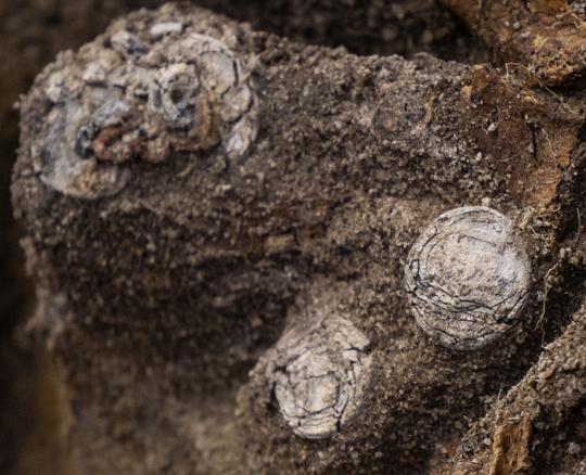
Buttons dating to the late 1700s, embossed with “USA,” were among artifacts found by archaeologists at the Revolutionary War battlefield near Camden on Friday Nov. 4, 2022. Gavin McIntyre/Staff
Steven Smith, research professor at the University of South Carolina’s Institute of Archaeology and Anthropology, said he and colleague James Legg first started exploring the Camden battlefield with metal detectors in 1998. Over the years, they have found and plotted around 4,000 artefacts. During the COVID pandemic, they opted to spend much of the time in the open air with their equipment; it was an easy way to stay safe from the virus.
The site, several miles north of the city, was designated a National Historic Landmark in 1961 and placed on the National Register of Historic Places in 1966. The S.C. Battleground Preservation Trust secured nearly 300 acres and transferred ownership of the property to the Katawba Valley Land Trust in 2019. In September, the archaeologists started excavating for human remains. Collectors had told them about eight known burials. Legg found three sites; Smith found one. Then they encountered another, and another, until they had identified one double grave, one triple grave, one quintuple grave and four graves that each contained the bones of a single person.
“It was a disposal process,” Legg said. “The Continentals fought like Vikings in this battle, but they were overrun.”
It’s said that every battlefield is a burial ground. And there is little time for reverence.
The excavation
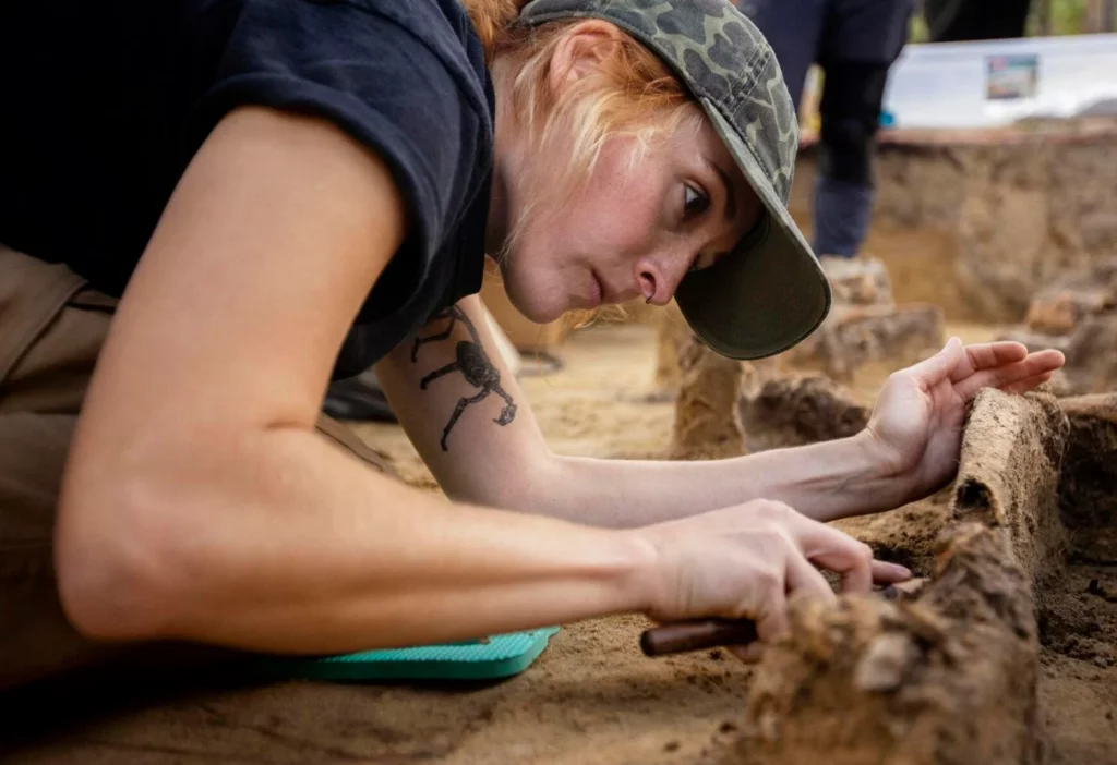
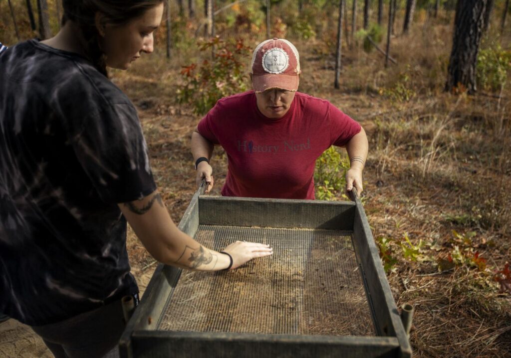
Bill Stevens, Richland County deputy coroner and a forensic anthropologist, is kneeling in the shallow gravesite with his two colleagues, Madeline Atwell and Rachel Baker. Loblolly pines tower overhead, but their spacing allows plenty of sunlight to reach the ground. A few flying bugs run accidentally into human obstacles.
The trio have exposed a cluster of five skeletons, digging delicately through the compact sand several inches beyond the bones that now are elevated atop earthen pedestals. Some of the appendages are intertwined and it’s difficult to determine which arm bone belongs to which individual. The dig looks like a miniature Bryce Canyon, except it wasn’t erosion that caused these formations, but an odd combination of human conflict and a researcher’s tiny spade.
Madeline Atwell, a forensic anthropologist with the Richland County Coroner’s Office, carves out a bone from the remains of a Revolutionary War soldier found at the site of the Battle of Camden on Friday Nov. 4, 2022. Gavin McIntyre/Staff
The coroners already have removed nine sets of remains; this is the last gravesite to receive their meticulous attention. Gently, they insert the small blade between the sand pedestal and the skeleton, dislodging enough material to free the bone. These shallow burial sites have been disturbed over the decades by wild creatures, loggers, wagons, road workers and farmers. It’s remarkable that the skeletal remains are intact.
Inside this grave, archaeologists find more than bones. A beautifully made arrowhead, thousands of years old, is lodged in the sand. Several musket balls, the cause of injury and death, are clearly visible. Pewter buttons embossed with “USA” lay among the other objects.
The number of interested spectators is growing. Charles Baxley, chairman of S.C. American Revolution 250th commission has arrived, along with Bonnie Moffat, state regent of the Daughters of the American Revolution. Baxter is overseeing an ambitious project to educate residents and visitors about the war and the founding of the nation. The work here will become an important part of the commission’s narrative, he said.
“These are America’s first veterans, and these veterans were unceremoniously dumped into a hole,” he said.
A Native American arrowhead was among the artifacts found during an archaeological dig at the site of the Battle of Camden on Friday Nov. 4, 2022. The arrowhead likely is thousands of years old. Gavin McIntyre/Staff
Moffat said her organization is arranging to install perhaps 10 historic markers at battlefields across the state in conjunction with the 250th-anniversary celebration. Each marker costs about $4,800, she said. One is planned for Camden.
The S.C. Battleground Preservation Trust has been busy in recent years securing several properties and arranging for public access. It has been partnering with the nonprofit American Battlefield Trust, based in Washington, D.C., to develop the Liberty Trail, a network of Revolutionary War sites in South Carolina. A website, https://www.battlefields.org/learn/maps/liberty-trail, features details about the various historic confrontations and provides maps for those interested in visiting these sites. Now the trust is raising money, as much as $250,000, to help pay for the Camden project and reinterment events, Bostick said.
The reinterment
Battlefield archaeology is a relatively new field of study, Legg said. The first big project took place in 1984-85 at the site of Gen. George Armstrong Custer’s last stand at the Battle of Little Bighorn in Montana. A grass fire ignited by a tossed cigarette had exposed artifacts and inspired scholars to investigate the area, Legg said. They found a lot: spent cartridges, fired bullets, personal items and human remains.
In 1988, Legg and Smith performed excavation work at a Civil War battle site on Folly Island where they discovered, and removed, 19 sets of human remains, including what was left of the Black soldiers of the 55th Massachusetts Regiment who died there. This was one of the first formally organized Black units to fight on behalf of the United States. Legg and Smith arranged for a reburial at the Beaufort National Cemetery. The Camden battlefield now is well-marked with stakes indicating the top of the head and the bottom of the feet of each skeleton exhumed so archaeologists know precisely where the custom pine caskets sealed with hand-wrought nails are to lay, Smith said.
This will be no ordinary reinterment.
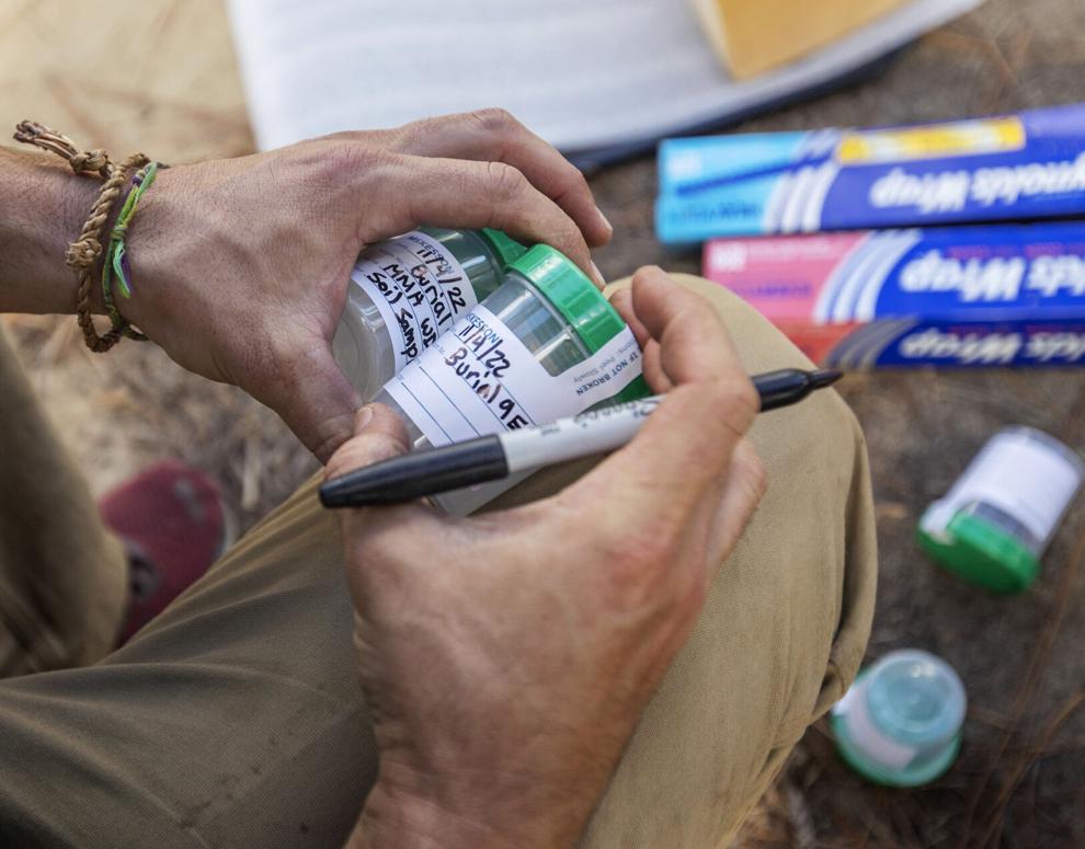
Robert Gibbes, with the South Carolina Department of Natural Resources, marks containers for soil samples during the removal of human remains from a gravesite on the Camden battlefield on Friday Nov. 4, 2022. Gavin McIntyre/Staff
After about five months of study in the lab, the skeletal remains unearthed at the old battlefield will lie in state at the Kershaw-Cornwallis House from April 20 until the morning of April 22, Bostick said. On April 21, reenactors will set up an encampment by the house. An outdoor concert is planned for that evening.
The next morning, participants will process a mile north to Bethesda Presbyterian Church for a joint Anglican-Presbyterian religious service honouring the fallen soldiers. That afternoon, people will gather at the battlefield for a secular ceremony and reburial. Organizers have informed Gov. Henry McMaster of the events, and they have reached out to the state’s congressional delegation and to British officials. Horse-drawn caissons already are reserved.
Bostick said he expects some or all of the events to be live-streamed.
The X-rays and strontium isotope analysis likely will shed light on exactly how these men died, their age at the time of death, and the precise circumstances of their death. The DNA analysis will take a bit longer to complete, perhaps returning results during the summer.
Linsay Mitchell, an intern with the Richland County Coroner’s Office, helps Stacey Ferguson, of the Historic Camden Foundation, on Nov. 4, 2022, sift through dirt from a gravesite where five soldiers killed in the 1780 Battle of Camden were buried. Gavin McIntyre/Staff
The Battle of Camden “is the outstanding symbol of a series of disastrous setbacks suffered by the American side in the South during The War for Independence,” the National Park Service noted on its National Registry of Historic Places nomination form. “These losses, the surrender of Charleston, the wipe-out at Waxhaws, and then Camden, represent the lowest point to which American fortunes sank in that struggle.”
It was a rout that prompted Gates, the commanding officer, to flee along with many of his men, abandoning the now outnumbered Continental regulars to their fate. Their commander, Maj. Gen. Johann de Kalb, was mortally wounded. Congress wanted an inquiry into Gates’ actions, but it never came to pass. Gates was reassigned and Gen. Nathanael Greene assumed command of the Southern forces. It was a consequential change of leadership, a turning point in the war. Over the next two years, Greene and the fighters he commanded succeeded in driving the enemy from the Carolinas and Georgia. On Dec. 14, 1782, the British completed their evacuation of Charleston, boarding ships at Gadsden’s Wharf and sailing off. The war was coming to an end.
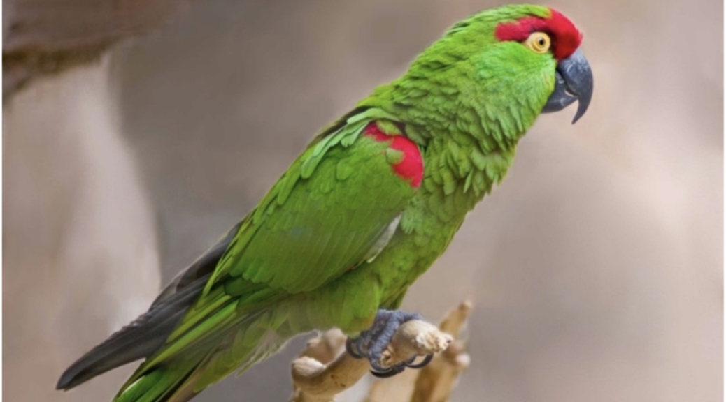
Old bone links lost American parrot to ancient Indigenous bird trade
For centuries, Indigenous communities in the American Southwest imported colourful parrots from Mexico. But according to a study led by The University of Texas at Austin, some parrots may have been captured locally and not brought from afar.
The research challenges the assumption that all parrot remains found in American Southwest archaeological sites to have their origins in Mexico. It also presents an important reminder: The ecology of the past can be very different from what we see today.
“When we deal with natural history, we can constrain ourselves by relying on the present too much,” said the study’s author, John Moretti, a doctoral candidate at the UT Jackson School of Geosciences. “These bones can give us kind of a baseline view of the animal life of the ecosystems that surrounded us before huge fundamental changes that continue today began.”
Parrots are not an uncommon find in southwestern archaeological sites dating as far back as the 7th or 8th centuries. Their remains have been found in elaborate graves and buried in trash heaps. But no matter the condition, when archaeologists have discovered parrot bones, they usually assumed the animals were imports, said Moretti.
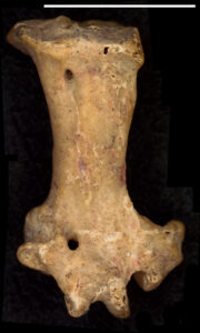
The tarsometatarsus, or ankle bone, of a thick-billed parrot. The bone was collected at an archaeological dig in New Mexico during the 1950s. UT doctoral student John Moretti identified the bone as belonging to a parrot.
There’s a good reason for that. Scarlet macaws — the parrot most commonly found in the archaeological sites — live in rainforests and savannahs, which are not part of the local landscape. And researchers have discovered the remains of ancient parrot breeding facilities in Mexico that point to a thriving parrot trade.
But there is more to parrots than macaws. In 2018, Moretti found a lone ankle bone belonging to a species known as the thick-billed parrot. It was part of an unsorted bone collection recovered during an archaeological dig in the 1950s in New Mexico.
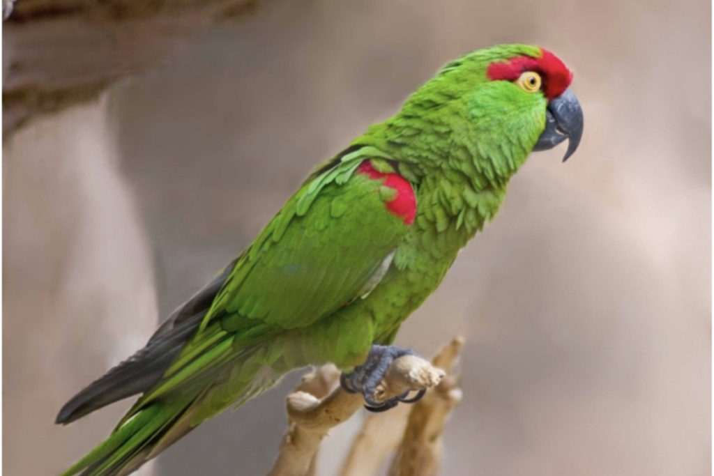
A thick-billed parrot.
“There was a lot of deer and rabbit, and then this kind of anomalous parrot bone,” said Moretti, a student in the Jackson School’s Department of Geological Sciences. “Once I realized that nobody had already described this, I really thought there was a story there.”
Thick-billed parrots are an endangered species and do not live in the United States today due to habitat loss and hunting. But that was not the case even a relatively short time ago. As recently as the 1930s, their range stretched from Arizona and New Mexico to northern Mexico, where they live today. The boisterous, lime-green birds are also very particular about their habitat. They dwell only in mountainous old-growth pine forests, where they nest in tree hollows and dine almost exclusively on pine cones.
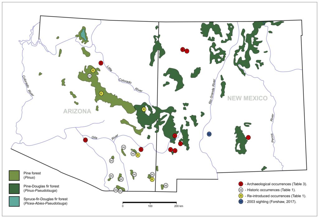
With that in mind, Moretti decided to investigate the connection between pine forests in New Mexico and Arizona and the remains of thick-billed parrots found at archaeological sites. He found that of the 10 total archaeological sites with positively identified thick-billed parrot remains, all contained buildings made of pine timber, with one settlement requiring an estimated 50,000 trees. And for half the sites, suitable pine forests were within 7 miles of the settlement.
Moretti said that with people entering parrot habitat, it’s plausible to think they captured parrots when gathering timber and brought them home.
A map showing the distribution of mountainous pine forests and thick-billed parrot occurrences. This includes parrot remains recovered from archaeological sites and recent sightings.
“This paper makes the hypothesis that these [parrots] were not trade items,” Moretti said. “They were animals living in this region that were caught and captured and brought home just like squirrels and other animals that lived in these mountains.”
Moretti relied on thick-billed parrot bones from the United States and Mexico permanently archived in collections at The University of Kansas Biodiversity Institute and the Smithsonian Institution to conclusively identify the lone bone that sparked the research.
Mark Robbins, an evolutionary biologist and the collection manager of the ornithological collections at The University of Kansas, said this study shows the value of natural history collections and the innumerable ways they assist with research.
“The scientists who originally collected those specimens, they had no idea they would be used in this fashion,” Robbins said. “You can revisit old questions or formulate new questions based on these specimens.”
The research was funded by the Museum of Texas Tech University, where Moretti earned a master’s degree.
Revolutionary War Prison Camp Found in Pennsylvania
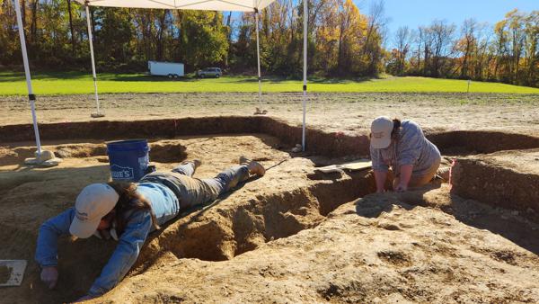
In this photo provided by John Crawmer, Jane C. Skinner and Samantha Muscella excavate post holes at the bottom of a stockade trench, Thursday, Oct. 27, 2022, in York, Pa. Researchers say they have solved a decades-old riddle by finding remnants of the stockade and therefore the site of a prison camp in York, that housed British soldiers for nearly two years during the American Revolutionary War.
Researchers say they solved a decades-old riddle this week by finding remnants of the stockade and therefore the site of a prison camp in York, Pennsylvania, that housed British soldiers for nearly two years during the American Revolutionary War.
The location of Camp Security was thought to have been on land acquired by the local government nearly a decade ago. On Monday, an archaeological team working there located what they believe to be the prison camp’s exterior security fence.
The camp housed more than 1,000 English, Scottish and Canadian privates and noncommissioned officers for 22 months during the war, starting with a group of prisoners who arrived in 1781, four years after their surrender at Saratoga, New York. By the next year, there were some 1,200 men at the camp, along with hundreds of women and children.
In this photo provided by John Crawmer, Jane C. Skinner excavates post holes at the bottom of a stockade trench, Thursday, Oct. 27, 2022, in York, Pa. Researchers say they have solved a decades-old riddle by finding remnants of the stockade and therefore the site of a prison camp in York, that housed British soldiers for nearly two years during the American Revolutionary War.
Fieldwork at the site, which also includes the lower-security Camp Indulgence, has gone on for decades, but the exact spot of Camp Security — where prisoners from the 1781 Battle of Yorktown, Virginia, were kept — had been unknown until a telltale pattern of post holes in a foot-deep trench was uncovered.
“This has been a long project, and to finally see it come to fruition, or at least know you’re not nuts, that’s wonderful,” said Carol Tanzola, who as president of Friends of Camp Security led fundraising for the project.
Lead archaeologist John Crawmer said the location site had been narrowed down after about 28 acres (11 hectares) were ploughed for metal detection and surface collection of artefacts in 2020. That further reduced the search area to about 8 acres (3 hectares), where long exploratory trenches were dug last year.
Those trenches helped the team identify post holes that in turn led to the pattern of holes and a stockade trench that matched stockades at other 18th-century military sites, Crawmer said.
Next spring, Crawmer and other researchers hope to determine the full size of the stockade and perform a focused search for artefacts within and around it.
“Was it circular or square, what’s inside, what’s outside?” Crawmer said. “As we do that, we’re going to start finding those 18th-century artefacts, the trash pits. We’ll be able to start answering questions about where people were sleeping, where they were living, where they were throwing things away, where the privies are.”
Crawmer said there is evidence the vertical posts that formed the security stockade were not in the ground for very long and that they may have been dug up and reused after the camp was closed in 1783.
A contemporaneous account of camp life by a British surgeon’s mate said there was a “camp fever” that might have killed some of the prisoners, and a list of Camp Security inmates was located in the British National Archives. No human remains have been found at the site.
Historians confirmed local lore about the general location of Camp Security and Camp Indulgence after a 1979 archaeological study of a small portion of the property produced buckles, buttons and other items associated with British soldiers of the period. That survey also found 20 coins and 605 straight pins that may have been used by prisoners to make lace.
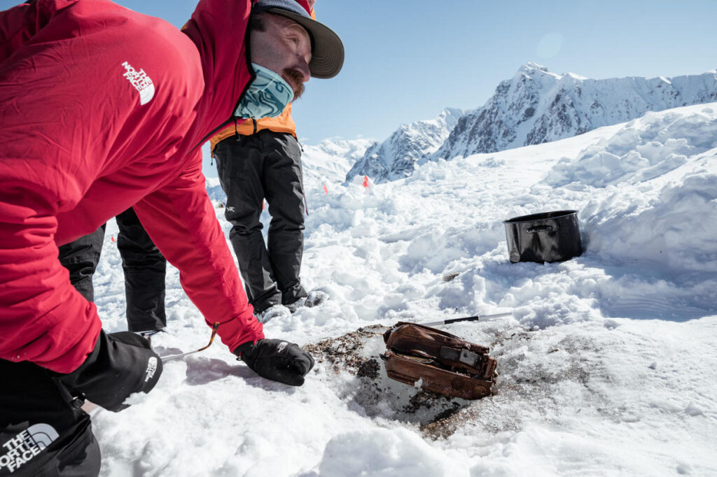
A camera left in the Yukon by a legendary explorer in 1937 is found 85 years later
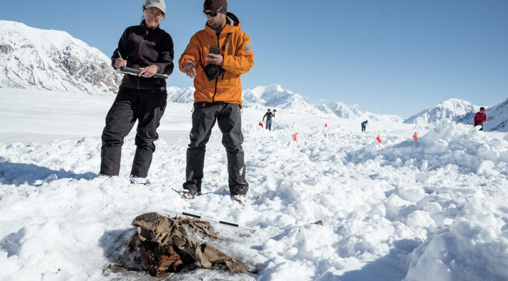
In 1937, legendary mountaineers Bradford Washburn and Robert Bates were exploring Canada’s frigid Yukon region when they had to abandon their gear in order to quickly escape. Nearly 85 years later, the cache of gear they left behind has been found – including Washburn’s camera.
Professional mountain explorer Griffin Post told CBS News he first heard about the abandoned cache in the book “Escape from Lucania.” Author David Roberts writes about where Washburn and Bates may have left the cache of gear in the Kluane National Park and Reserve.
“But nobody really knew for sure, and that doubt and that possibility that it was still there is what I went on,” Post said.
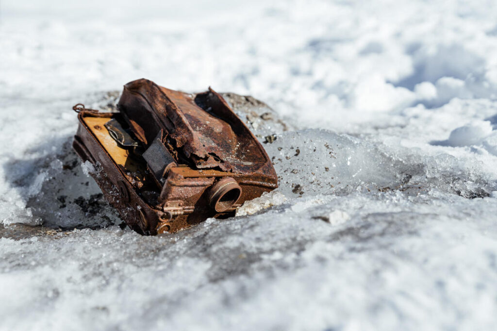
Griff Post and the Washburn’s camera, which was embedded in the ice of Walsh Glacier.
Washburn is a mountaineer, explorer, surveyor, mapmaker and author who is also known for the photos he took of the dramatic landscapes he explored. He’s visited many of the world’s wild regions, including remote Alaska and Mount Everest.
Post said Washburn and Bates abandoned their gear because their pilot couldn’t come back to pick them up, so they decided to summit the peak and hike out into Canada. They planned to come back the following winter but never did.
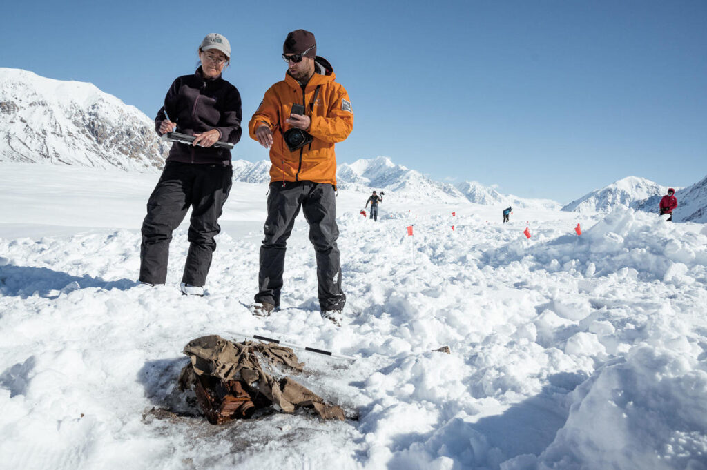
On a quest to find the cache, Post led a team to the remote Walsh Glacier. Post and Teton Gravity Research — which produces skiing, snowboarding and surfing films — partnered with University of Ottawa Glaciologist Dora Medrzycka, who travelled with them, and mapped out the glacier to determine where the gear could have moved over time. Dr. Luke Copland and a team at the University of Ottawa helped them remotely.
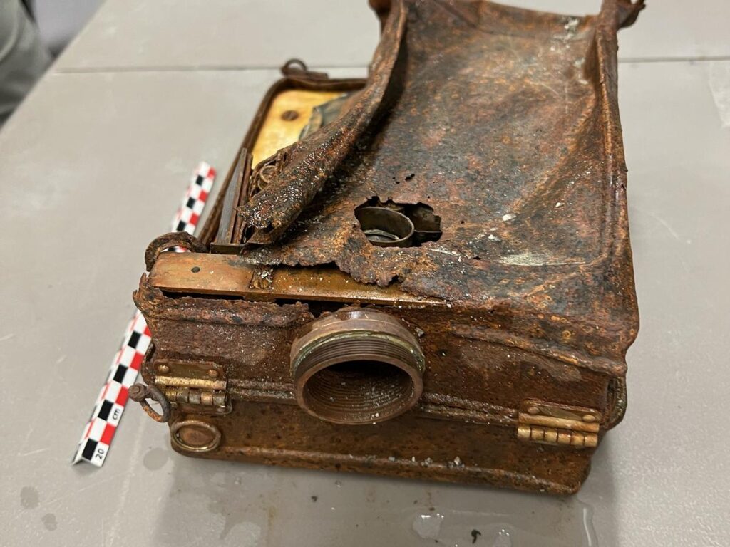
The team found a portion of Washburn’s aerial camera, which is believed to be his first-ever aerial photography camera, according to a press release from Teton Gravity Research. They were also able to retrieve two other cameras with film still loaded inside.
“It was such an emotional rollercoaster because you go in, you’ve done all this research, you’re so excited, and then the first time you fly in you see how vast the terrain is and how much area you’re supposed to cover and how many crevasses the cache could’ve fallen into years ago,” Post said. “It’s like ‘I don’t think there’s any way we can find this.’ It’s so overwhelming.”
However, Post said, searching for the cache ended up feeling fun.
“At times I felt like a little kid. You’re jumping over a crevasse, like looking for treasure essentially. Like this is wild I get to do this,” he said. “And if we don’t find anything, well as far as adventure goes, we checked that box.”
During a seven-day trip, the crew of seven people searched on foot, ski and snowboard, travelling about 60 miles each, Post said.
“We found it on the morning of the seventh day,” he added. “It took every minute basically, and in the end, the helicopter was about to take off to come pick us back up, and that was when we found the cache.”
The team of seven searched for seven days, travelling about 60 miles before finding the cache on the final day of their trip.
The team found a portion of Washburn’s aerial camera, which is believed to be his first-ever aerial photography camera, according to a press release from Teton Gravity Research. They were also able to retrieve two other cameras with film still loaded inside.
Archaeologists from Parks Canada, which oversees national parks in the country, returned to the glacier with the team a few weeks later and helped them carefully retrieve what they could, successfully extracting the camera from the ice, according to the press release.
Post said they will be “examined in the coming weeks and we’re cautiously optimistic something will be salvageable.”
Post said they will be “examined in the coming weeks and we’re cautiously optimistic something will be salvageable.”
The team estimated the camera had moved about 12 miles from where it started, Post said. Until this point, scientists only had data about glacier movement dating back to the 1960s, and analyzing the movement of the cache since 1937 can help them better understand how the velocity and thickness of a glacier may have changed.
Post said not only was it historically significant to find the cache but “the science was almost cooler.”
“Because we essentially backfilled three decades of data the science community didn’t have as far as how glaciers moved,” he added.