Defiant message discovered in Cuban Missile Crisis bunker
Sixty years ago during the Cuban Missile Crisis, a defiant individual — likely a Cuban soldier — wrote a message in a system of bunkers and trenches on the Cuban coast declaring that surrender was not in the cards, new research finds.
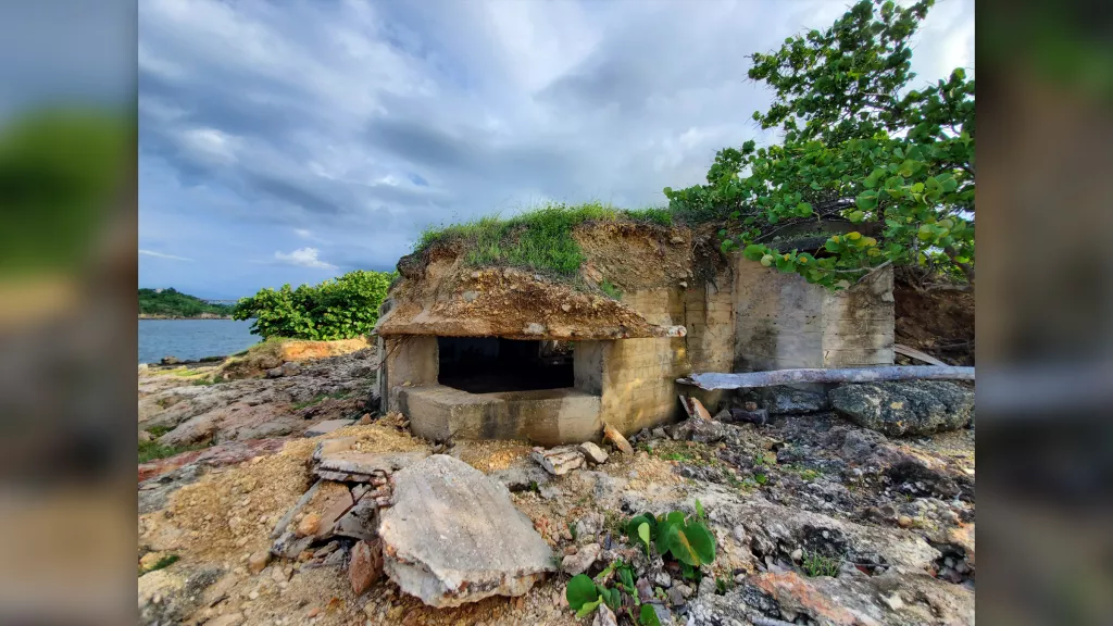
This photo shows a bunker that was built to defend the island in case the Americans invaded during the Cuban Missile Crisis.
Archaeologists discovered the graffiti while documenting the remains of these bunkers and trenches, which Cuba prepared in case the United States invaded the island during the 1962 Cuban Missile Crisis — a 13-day standoff that brought the world to the brink of nuclear war.
The individual’s message, written in Spanish, indicates that they were determined to fight in the event of war breaking out.
Another photo of a bunker. The Cuban Missile Crisis brought the world to the brink of nuclear war.
The bunkers and trenches combined with storage areas formed an interconnected system of fortifications.
The crisis, which occurred in October 1962 during the Cold War, flared up when the Soviet Union placed nuclear missiles on communist-controlled Cuba — about 124 miles (200 kilometers) from the U.S. coast.
The United States responded by blockading the Caribbean island and threatening to invade it if the nuclear weapons were not removed — bringing the two nuclear superpowers close to World War III.
An agreement was eventually reached in which the Soviet Union withdrew nuclear missiles from Cuba in exchange for the United States removing nuclear missiles from Turkey.
While the United States did not launch a full-scale invasion of Cuba, the system of bunkers and trenches that were built to defend the island still remains.
Some of the people stationed in these fortifications left defiant messages on the walls. “Some inscriptions relating to the time of the Missile Crisis are very interesting, including one that reads: ‘aquí no se rinde nadie’ (no one is giving up here),” Odlanyer Hernández de Lara, a doctoral candidate in archaeology at the Maxwell School of Citizenship and Public Affairs of Syracuse University in New York, told Live Science in an email.
Archaeologists are documenting these Cold War defenses using 3D photogrammetry — a technique in which a multitude of digital photos are taken of an object and then processed by software to create a digital 3D model.
The system of bunkers and trenches formed an interconnected system of fortifications designed to stop American troops from landing in Cuba.
“These bunkers are concrete structures with a main and an elevated/secondary embrasure [opening] facing the sea, and a main rear entrance with two alternative exits to the sides,” de Lara said. “The trenches are excavated into bedrock, connecting the bunkers with [a] storage area.”
Some of the bunkers and trenches are in good shape, but others have been damaged by coastal erosion or other effects due to the passage of time, de Lara said.
The Cuban military stopped using them sometime after the missile crisis and they are now abandoned.
The research, which is not yet published in a peer-reviewed journal, was presented at the annual meeting of the Society for American Archaeology (SAA) that was held in Chicago from March 30 to April 3.
The SAA paper was co-authored by Esteban Grau González-Quevedo, a researcher at the Antonio Núñez Jiménez Foundation for Nature and Humanity (FANJ), a scientific institution in Cuba.
Rare 1000-Year-Old Maya Canoe Found in Yucatan Cenote
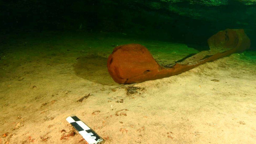
Archaeologists have discovered a wooden Maya canoe in southern Mexico, believed to be over 1,000 years old. Measuring over 5ft (1.6m), it was found almost completely intact, submerged in a freshwater pool near the ruined Maya city of Chichen Itza.
Archaeologists also found fragments of ceramics and a ritual knife during the excavation in southern Mexico
Mexico’s antiquities institute (Inah) says it may have been used to extract water or deposit ritual offers.
The rare find came during construction work on a new tourist railway known as the Maya Train.
Experts from Paris’s Sorbonne University have been helping with pin-pointing the canoe’s exact age and type, the statement said. A 3D model of it would also be made to allow replicas to be made, and to facilitate further study, it added.
It’s believed the canoe may have been used to extract water from the pool or to make ritual offerings
The Maya civilisation flourished before Spain conquered the region. In their time, the Mayas ruled large stretches of territory in what is now southern Mexico, Guatemala, Belize and Honduras.
The boat has been tentatively dated between 830-950 AD, towards the end of the Maya civilisation’s golden age.
Around this period, the Mayas suffered a major political collapse, marked by the abandonment of cities dotted around modern-day Central America – leaving ruins of towering pyramids and other stone buildings.
No single theory for this collapse has been widely accepted, but it is believed a combination of internal warfare, drought and overpopulation may have been contributing factors.
The Maya Train is a multi-billion-dollar project, led by President Andrés Manuel López Obrador’s government, which will run through five southern Mexican states.
Advocates have said the rail network will help to alleviate poverty in the region. But critics argue that it risks damaging local ecosystems and undiscovered sites of historic importance.
Lost Maya City Inside Volcano Crater Explored by Archaeologists
A lost Mayan city that collapsed inside a volcano crater has been explored by a team of archaeologists. In the Late Preclassic period—400 BC to AD 250—there was a thriving Mayan city consisting of temples, houses and squares, in the middle of the volcanic Lake Atitlán.
The Atitlán, situated in the highlands of Guatemala, lies within a volcano carter more than 5,000 feet above sea level.
A catastrophic event—which experts believe was caused by some sort of volcanic activity—caused the city to collapse from its bottom, forcing the Mayans to flee.
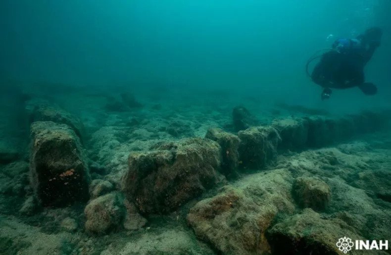
Archaeologists dove into the Lake’s depths to explore the lost city
The city sunk into the Atitlán’s depths and now lies 39 and 65 feet below its surface, according to Mexico’s National Institute of Anthropology.
The lost city has now been explored by a team of archaeologists, lead by the head of the Yucatan Peninsula Office at the National Institute of Anthropology, Helena Barba Meinecke. Their aim was to raise awareness of the city’s significance to the Indigenous communities in the region and promote its conservation.
To reach the sunken city, archaeologists carried out dives in the area.
During the dives, archaeologists uncovered the remains of buildings, columns, ceremonial stones, and other structures. From these findings, they were able to generate a planimetric map of the city.
“With this planimetry, we can speak of a site that measures at least 200 by 300 meters,” Barba Meinecke said in a statement.
Archaeologists also gathered silt samples from the lake in order to assess the dynamics of the site and measure its decay over time. The exploration also laid “groundwork” for a cultural centre, which will allow people to explore the site virtually.
It is not the only archaeological site within Lake Atitlán. There are two other lost cities lying below the surface of the lake called Samabaj and Chiutinamit.
Samabaj was the first underwater Mayan ruin excavated in Guatemala in Lake Atitlán. It was discovered in the late 1990s by a scuba diver who had been exploring the lake’s depths, according to a Reuters report from 2009.
The Maya civilization was an Indigenous society stretching across what is now Mexico and Central America. The earliest settlements in the Maya civilization were formed during the Preclassic period. The civilization thrived for over 3,000 years until it mysteriously disappeared. Towards the end of the ninth century, cities were gradually abandoned one by one.
To this day, experts are still unsure what happened but there are several theories. One is that ongoing warfare among cities caused a breakdown, while others believe that the civilization could no longer thrive in the surrounding environment.
Archaeologists found ceremonial stones and the remains of buildings during their exploration
Tanis: Fossil found of dinosaur killed in an asteroid strike, scientists claim
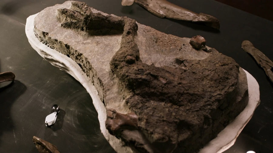
Scientists have presented a stunningly preserved leg of a dinosaur. The limb, complete with skin, is just one of a series of remarkable finds emerging from the Tanis fossil site in the US State of North Dakota. But it’s not just their exquisite condition that’s turning heads – it’s what these ancient specimens are purported to represent.
Tanis: Fossil found of dinosaur killed in an asteroid strike, scientists claim
The claim is the Tanis creatures were killed and entombed on the actual day a giant asteroid struck Earth. The day 66 million years ago when the reign of the dinosaurs ended and the rise of mammals began. Very few dinosaur remains have been found in the rocks that record even the final few thousand years before the impact. To have a specimen from the cataclysm itself would be extraordinary.
The BBC has spent three years filming at Tanis for a show to be broadcast on 15 April, narrated by Sir David Attenborough. Sir David will review the discoveries, many of that will be getting their first public viewing. Along with that leg, there are fish that breathed in impact debris as it rained down from the sky.
We see a fossil turtle that was skewered by a wooden stake; the remains of small mammals and the burrows they made; skin from a horned triceratops; the embryo of a flying pterosaur inside its egg; and what appears to be a fragment from the asteroid impactor itself.
“We’ve got so many details with this site that tells us what happened moment by moment, it’s almost like watching it play out in the movies. You look at the rock column, you look at the fossils there, and it brings you back to that day,” says Robert DePalma, the University of Manchester, UK, a graduate student who leads the Tanis dig.
Robert DePalma: “Dinosaurs and the impact are two things that are absolutely linked in our minds”
It’s now widely accepted that a roughly 12km-wide space rock hit our planet to cause the last mass extinction. The impact site has been identified in the Gulf of Mexico, off the Yucatan Peninsula. That’s some 3,000km away from Tanis, but such was the energy imparted in the event, its devastation was felt far and wide.
The North Dakota fossil site is a chaotic jumble.
The remains of animals and plants seem to have been rolled together into a sediment dump by waves of river water set in train by unimaginable earth tremors. Aquatic organisms are mixed in with land-based creatures.
The sturgeon and paddlefish in this fossil tangle are key. They have small particles stuck in their gills. These are the spherules of molten rock kicked out from the impact that then fell back across the planet. The fish would have breathed in the particles as they entered the river.
The spherules have been linked chemically and by radiometric dating to the Mexican impact location, and in two of the particles recovered from preserved tree resin, there are also tiny inclusions that imply an extraterrestrial origin.
“When we noticed there were inclusions within these little glass spherules, we chemically analysed them at the Diamond X-ray synchrotron near Oxford,” explains Prof Phil Manning, who is Mr DePalma’s PhD supervisor at Manchester.
“We were able to pull apart the chemistry and identify the composition of that material. All the evidence, all of the chemical data, from that study suggests strongly that we’re looking at a piece of the impactor; of the asteroid that ended it for the dinosaurs.”
Sir David examines the remains of a triceratops dinosaur
The existence of Tanis, and the claims made for it, first emerged in the public sphere in the New Yorker Magazine in 2019. This caused a furore at the time.
Science usually demands the initial presentation of new discoveries is made in the pages of a scholarly journal. A few peer-reviewed papers have now been published, and the dig team promises many more as it works through the meticulous process of extracting, preparing and describing the fossils.
To make its TV programme, the BBC called in outside consultants to examine a number of the finds. Prof Paul Barrett from London’s Natural History Museum looked at the leg. He’s an expert in ornithischian (mostly plant-eating) dinosaurs.
“It’s a Thescelosaurus. It’s from a group that we didn’t have any previous record of what its skin looked like, and it shows very conclusively that these animals were very scaly like lizards. They weren’t feathered like their meat-eating contemporaries.
“This looks like an animal whose leg has simply been ripped off really quickly. There’s no evidence on the leg of disease, there are no obvious pathologies, there’s no trace of the leg being scavenged, such as bite marks or bits of it that are missing,” he tells me.
“So, the best idea that we have is that this is an animal that died more or less instantaneously.”
Artwork: The thinking is that a water surge buried all the creatures at Tanis
The big question is whether this dinosaur did actually die on the day the asteroid struck, as a direct result of the ensuing cataclysm. The Tanis team thinks it very likely did, given the limb’s position in the dig sediments.
If that is the case, it would be quite the discovery.
But Prof Steve Brusatte from the University of Edinburgh says he’s sceptical – for the time being.
He’s acted as another of the BBC’s outside consultants. He wants to see the arguments presented in more peer-reviewed articles, and for some palaeo-scientists with very specific specialisms to go into the site to give their independent assessment. Prof Brusatte says it’s possible, for example, that animals that had died before the impact was exhumed by the violence on the day and then re-interred in a way that made their deaths appear concurrent.
“Those fish with the spherules in their gills, they’re an absolute calling card for the asteroid. But for some of the other claims – I’d say they have a lot of circumstantial evidence that hasn’t yet been presented to the jury,” he says.
“For some of these discoveries, though, does it even matter if they died on the day or years before? The pterosaur egg with a pterosaur baby inside is super-rare; there’s nothing else like it from North America. It doesn’t all have to be about the asteroid.”
A pterosaur embryo inside an egg was found at the Tanis site…
…here digitally extracted and constructed into a model
There’s no doubting the pterosaur egg is special.
With modern X-ray technology, it’s possible to determine the chemistry and properties of the eggshell. It was likely leathery rather than hard, which may indicate the pterosaur mother buried the egg in sand or sediment like a turtle.
It’s also possible with X-ray tomography to extract virtually the bones of the pterosaur chick inside, print them and reconstruct what the animal would have looked like. Mr DePalma has done this. The baby pterosaur was probably a type of azhdarchid, a group of flying reptiles whose adult wings could reach more than 10m from tip to tip.
Mr DePalma gave a special lecture on the Tanis discoveries to an audience at the US space agency Nasa’s Goddard Space Flight Center on Wednesday. He and Prof Manning will also present their latest data to the European Geosciences Union General Assembly in May.
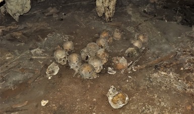
Collection of Ancient Toothless Skulls Analyzed in Mexico
They all have the peculiarity of not having dental pieces, a trait registered in other mortuary caves of that entity.
The analysis of approximately 150 skulls indicates that these correspond to individuals decapitated between 900 and 1200 AD. C.
A decade ago, a complaint alerted the Chiapas authorities about the presence of human remains in a cave in the town of Carrizal, in the municipality of Frontera Comalapa. Believing to be at the scene of a crime, the researchers collected the bone elements and began their analysis in Tuxtla Gutiérrez, and with the collaboration of the National Institute of Anthropology and History (INAH), it was possible to determine that the bones were pre-Hispanic.
Since then, analyzes have been carried out that allow INAH physical anthropologists to delve into a funerary context that is approximately a thousand years old and even theorize that there was an altar of skulls, or tzompantli, in the Comalapa Cave.
Physical anthropologist Javier Montes de Paz, a researcher at the INAH Chiapas Center, disseminated the preliminary results of said research in a virtual conference, as part of the “With you in the distance” campaign, of the Ministry of Culture of the Government of Mexico, in the which pointed out the factors that support such a hypothesis.
One of them, he said, is that, although long bones of femurs, tibias or radii have been identified, until now not a single complete burial has been recognized but mostly skulls or fragments of these, which is why it is a context of numerous individuals who were beheaded.
“We still do not have the exact calculation of how many there are, since some are very fragmented, but so far we can talk about approximately 150 skulls,” said the specialist, providing a summary of the preventive conservation, cleaning and cataloguing work applied in each one of them.
The second factor by which Montes de Paz posits the existence of a tzompantli is the evidence of traces of aligned wooden sticks, according to the record raised in the cave by the then Chiapas State Attorney General’s Office in 2012.
According to the physical anthropologist, the fact that the skulls of Comalapa do not have perforations in the parietal and temporal bones –like those of the Huei tzompantli of Tenochtitlan–, is explained by the knowledge about altars that used structures to fix the skulls without perforating them.
“Many of these structures were made of wood, a material that disappeared over time and could have collapsed all the skulls,” he said.
Together with archaeologists from the INAH Chiapas Center, it has been established that the bone remains of the Comalapa Cave have cranial modifications of the erect tabular type and that they date from the Early Postclassic (900 and 1200 AD).
“We have recognized the skeletal remains of three infants, but most of the bones are from adults and, until now, they are more from women than from men,” said the researcher, noting that a common characteristic of the skulls is that none of them preserves the teeth.
Although it has not yet been established whether the teeth were extracted in life or postmortem, experts recognize precedents of this type in Chiapas: the Cueva de las Banquetas, explored in the 1980s by the INAH in the municipality of La Trinitaria, where 124 skulls that did not preserve teeth were recovered.
Another case is the Cueva Tapesco del Diablo, discovered in 1993 by Mexican and French explorers in the municipality of Ocozocoautla. Five skulls were discovered there with the particularity of having been placed on a wooden tapesco (grid).
The physical anthropologist Javier Montes de Paz emphasized the need to continue with the research in the complex, and even carry out new field seasons in the Cueva de Comalapa.
In this sense, he highlighted the responsibility that citizens must have to respect these spaces that were often used for rituals and pointed out that irregular visits affect the archaeological heritage, sometimes irreversibly.
“The call is that when people locate a context that is likely to be archaeological, they avoid intervening and notify the local authorities or the INAH directly,” he concluded.
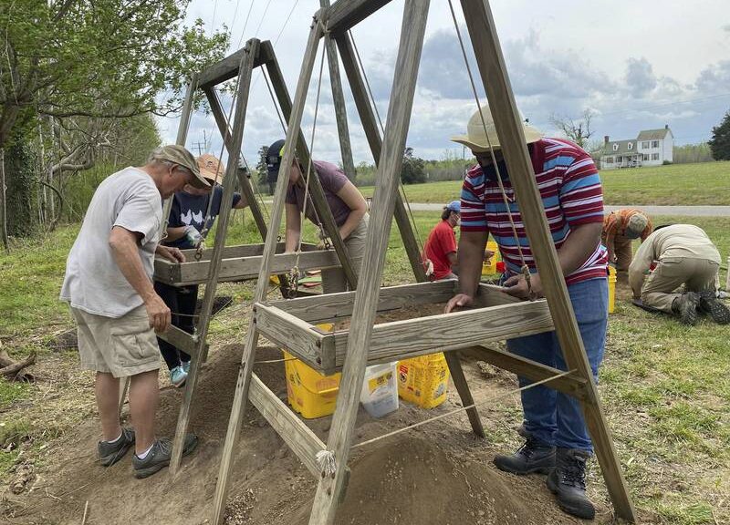
Possible 18th-Century Tavern Uncovered in Eastern Virginia
After three years of searching, archaeologists think they may have found the remnants of an 18th-century tavern.
“We found a substantial rubble deposit of handmade brick and oyster shell mortar with some evidence of burning [that may be chimney soot],” said Fairfield Foundation lead archaeologist Dan Brown. “We think it might be the Quarles Tavern.”
Although not much is known about the tavern other than what is recorded in historical documents, the tavern was owned at one time by a man named John Quarles.
Volunteers Tom Hawkins, Bonnie Pearsall, Elcke Erb, T’ziyon Levi-Shackleford, Marc Reynolds and Marshall Pearsall work with Fairfield Foundation staff archaeologist Oliver Mueller-Heubach at the site believed to be the location of an 18-century tavern in King William County’s courthouse area.
Now that archaeologists have identified what they think is the tavern, Brown said they will conduct additional tests to “find the edge of the deposit, hoping it will confirm the width of the building’s foundation … and delineate the building’s outline and dimensions” to verify it is the tavern.
The King William Historical Society sponsored the project after Alonso Dill’s map of the historic courthouse area, based on old records, piqued the society’s interest. It soon joined forces with the Fairfield Foundation, an archaeological preservation organization based in Gloucester.
Fairfield Foundation staff archaeologists Oliver Mueller-Heubach and Ned Rose work with volunteers Marc Reynolds, Mike Crombie, Charles Van Fossen and Marshall Pearsall at a site believed to have been the location of an 18th-century tavern in King William County’s courthouse area.
According to Brown, Dill’s map provided approximate locations of several buildings that no longer exist, including Hill’s Hotel (located across Courthouse Road in the green triangle lot), the Quarles Tavern (located east of the short brick wall area) and the brick stables (located in the asphalt overflow parking lot on Horse Landing Road).
Using Dill’s map and Ground Penetrating Radar (GPR) performed by Bob Chartrand, of Chartrand Geoarchaeological Solutions, LLC, in Williamsburg, they were able to search the entire courthouse area. GPR uses subsurface mapping of the earth using radio waves that create a picture.
“It saves us a lot of time and tells us where exactly to dig,” Brown said.
With GPR, Chartrand located many of the buildings’ foundations and even one not on Dill’s map, including a large brick building with a full cellar within the short-bricked wall area of the courthouse, just south of the King William Historical Society Museum, Brown said.
“That area was privately owned up until the early 20th century, and the building was destroyed around the time the county bought the property but, what was the building?” he asked. “We’re still trying to find that out.”
Although his team is at the preliminary stages of understanding what exactly the archaeology says about King William’s society in the 18th century, Brown said that he can confirm that “the tavern hosted a very high-class clientele, [as] seen in the variety of relatively rare and expensive ceramic fragments, personal items and other artefacts found to date.”
Artefacts recovered from the upper layers above the brick rubble include (l-r) an oyster shell, two iron nails (potentially 18th-century wrought nails), a 19th-century white glass button, and an 18th-century slipware rim fragment and an unidentified iron object.
Brown has also deduced that the courthouse area was busy at that time. In fact, busier relative to today. Also, Brown said every part of society, from enslaved Africans and Indigenous people to wealthy individuals and families came to the courthouse area.
Although he has learned a lot about King William County through artefacts, Brown keeps digging up more questions.
This hole shows what archaeologists believe to be the foundation of an 18th-century tavern in King William County’s courthouse area.
“Did Indigenous people live here? When they built the courthouse, what other buildings were built alongside it and when and where? Over the 18th and 19th centuries, what government buildings came and went?”
Brown has a theory as to why business eventually slowed down in the King William courthouse area: urban development.
“There was an increase in state governments, development in West Point and more stores to choose from,” he said. “People had less of a need to go to the courthouse for things.”
Since the project is ongoing, the King William Society and Fairfield Foundation will continue to use GPR and dig around the courthouse area in hopes of finding new buildings and answering more questions.
According to Brown, the group also aims to “preserve the county’s precious cultural resources” by making them available for viewing in the King William Historical Society Museum and “sharing this process with the public.”
“Plans are in the works for us to host all 273 fourth and fifth graders in the county and that is a remarkable honour,” said Brown. “They would get to see the remarkable museum exhibits put together by the museum council, the architectural complexities and mysteries of our courthouse buildings, and get to dig too.”
Brown said he is also looking forward to hosting the public a few days every month to visit and participate in a dig.
Artifacts recovered from the upper layers above brick rubble include (top to bottom) a 19th-century whiteware handle fragment, a mid-18th-century white salt-glazed stoneware plate base fragment and a 19th-century colourless bottle fragment.
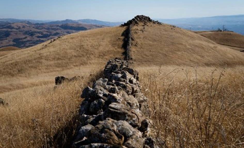
East Bay’s mysterious rock walls: Paranormal? American Stonehenge? Theories abound
If walls could speak, what a tale these mysterious huge boulders would tell. Perched high atop the lonely, windswept ridges of the Diablo Range, chains of stacked stones stand sentry above East Bay cities — yet they delineate nothing.
Long the subject of intrigue — Who built them? Why? How? — the walls are now being mapped by a San Francisco State archaeologist who believes they hold important clues to early California history and deserve our attention and protection.
“They are historic sites,” said Jeffrey Fentress, who is measuring and mapping them for the East Bay Regional Park District, then submitting his findings to the California Office of Historic Preservation. “By recording the walls, they become a permanent part of the state archive and are protected — as well as they can be — from future development.”
There are no written or photographic records of their construction in a landscape that has been inhabited by humans for at least 7,000 years. So, like the fabled crop circles of England, the walls have inspired theories ranging from the paranormal to the historically bizarre.
“There is no definitive answer on its origins, which further delights the public, who can take it to new levels of speculation,” said Mark Hylkema, archaeologist for the Santa Cruz District of California State Parks.
New Age mystics have declared that their builders were creatures from a vanished Pacific island; amateur historians suggest that they were Mongols or West Africans. Some theorize that the walls offered defence from intruders; others believe they played a peaceful and spiritual or astronomical role, perhaps serving as a “solstice site” like Stonehenge.
Sections of walls are scattered atop Santa Clara County’s Ed Levin County Park, the Russian Ridge in the Santa Cruz Mountains, several parks within the East Bay Regional Park District and a few private ranches in the Livermore Valley. Some also can be seen in the Sierra foothills, along state Highway 50 past El Dorado Hills.
A pile of rocks form a segment of “Mystery Walls” at Ed Levin County Park in Santa Clara County on Oct. 10, 2015.
While well known to the region’s hikers, park officials are reluctant to disclose precise locations because they fear they will attract vandals. A large stone circle on Pleasanton Ridge was destroyed by real estate development in the 1990s.
Standing 3- to 4-feet high and wide, they’re sturdy yet unsecured by mortar. They seem too low to offer much protection, or confine horses. Some rocks are melon-size. The larger ones weigh up to a ton. Lifting them no doubt required the effort of several men.
“Some go in a straight line, others twist like a demented snake up a steep hillside, others come in a spiral two hundred feet wide and circle into a boulder,” amateur wall historian Russell Swanson wrote in 1997. Over 12 years, he visited more than 40 miles of the stone structures. The walls seem out of place in California’s wild golden hills, evoking instead memories of tidy New England fields memorialized by poet Robert Frost, or the rich green pastures of Ireland.
One of many old stone walls found around the southern and eastern San Francisco Bay in California.
Why, in such a vast landscape, didn’t builders simply use barbed wire? Or wood? Instead, they’re built of coarse-grained sandstone, abundant in these hills, called graywacke.
Native Americans say they historically had little interest in erecting boundaries. “In general, our ancestors did not believe in scarring or altering Mother Earth,” said Valentin Lopez, chairman of the Amah Mutsun Tribal Band. In 1904, John Fryer, a UC Berkeley professor of Oriental languages and literature, asserted that they were “undoubtedly the work of Mongolians. … The Chinese would naturally wall themselves in.”
Several years later, ethnologist Henry C. Meyers agreed they were the product of strong and ancient civilizations: “Neither man nor men of the present day could possibly put large stones of these walls in place without appliances of some kind.”
Dr. Robert F. Fisher, the founder of the Mission Peak Heritage Foundation, told the Santa Cruz Sentinel in 1984 that he was mystified: “They predate the Indians. They predate the Spaniards. It doesn’t fit in with any of the later histories.”
More recently, lichen analyses date the walls back to the 1850s to 1880s — the post-Gold Rush era, when California was swelling with newcomers anxious to lay their claim on acreage. While imperfect, the technique dates inanimate objects by measuring the diameter of growing lichens.
That evidence hasn’t stopped the internet from spawning its own theories, crediting mythical Lemurians — tall people who breathed through scaly aqua skin and sought refuge in California after the disappearance of the Pacific continent of Mu. Much more likely is an explanation put forth by a consensus of experts like Fentress; State Parks archaeologist Hylkema; and Beverly Ortiz, cultural services coordinator of the East Bay Regional Park District.
The walls were likely built to contain cattle by new European immigrants in the post-Gold Rush era, perhaps using unpaid or low-paid Native American, Chinese or Mexican labour, they believe. The stones stand as a legacy of our once-rural culture, poignant reminders of people long gone. Unlike the railroad or mining tycoons — the Crockers, Stanfords, Huntingtons and Floods — these early ranchers left no mansions, antiques or jewellery. Only rocks.
“The rock walls throughout the East Bay are neither ancient nor mysterious, even if the specific individuals who made them are unknown to us today,” Ortiz said. “They are associated with historic Euro-American ranching, dairy and dry farming activities.”
The historians note that cattle and sheep don’t need tall walls to be managed; they’re docile and don’t jump. The rocks, Fentress and Ortiz said, also could have been used to help catch or drain water or establish boundaries between ranches.
But which ethnic group built the walls?
The Portuguese were among the early ranchers, said Robert Burrill and Joseph Ehardt, of the Milpitas Historical Society. But other immigrants, such as Italians, Irish and Spaniards, may have brought wall-building skills from their homelands.
These post-Gold Rush settlers, who were not wealthy, likely built walls with their own hands, Fentress said. But they also may have enlisted low-cost labour from other ethnic groups, such as Mexicans — who had been displaced from their ranchos — and Chinese, who build the railroads and projects like Oakland’s Lake Chabot dam. Or perhaps they were built by Native Americans during an era that authorized the forced apprenticeship of native peoples, a practice not banned until the 1860s.
Archaeologists say the walls are a ghostly elegy of their builders.
“They are essentially the archaeology of the working class, the common people who came here and made a living,” Fentress said. “It is the only evidence we have of these people’s lives — and it is important to tell that story as well as we can.”
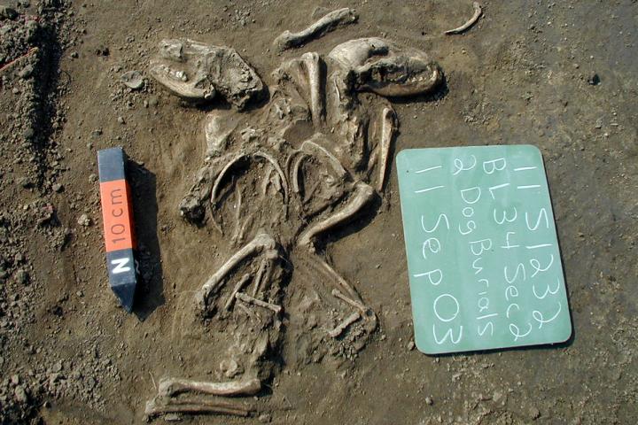
Remains of Ancient American Dogs Identified at Jamestown
Dogs first came to the Americas about 16,000 years ago, likely on the heels of ice age hunters crossing a bygone land bridge from Siberia. These indigenous canines remained on the continent for thousands of years as furry friends and hunting companions—until, suddenly, they were gone, replaced genetically by European breeds.
A modern reconstruction of the Jamestown colony
Now, a pair of jawbones pried from the earth beneath Virginia’s colonial Jamestown settlement may illuminate when these dogs vanished and the roles they may have played in the lives of both Native Americans and European colonists.
It’s a “pretty cool” study that provides a window into a period of time in which little is known about the continent’s first dogs, says Courtney Hofman, an anthropologist at the University of Oklahoma, Norman, who was not involved with the research. “A lot of work has focused on much older indigenous dogs, but less has been done on them in more recent times.”
When Spanish conquistadors arrived in the Americas in the 15th century, they brought with them large war dogs. Later European colonists brought over working dogs such as bloodhounds and greyhounds, as well as other hunting dogs.
Gradually, these European lineages almost completely replaced the indigenous dogs of the Americas. Today, only a few arctic breeds, such as Siberian huskies and Alaskan malamutes, are thought to retain a genetic connection to their ancient past.
How and when this dramatic genetic turnover happened remains unknown. So Ariane Thomas, a graduate student studying anthropology at the University of Iowa, turned to the remains of dogs uncovered at Jamestown between 2007 and 2010.
Jamestown was the first permanent English settlement in the Americas, founded largely by explorers with little farming experience.
Thomas managed to extract mitochondrial DNA (mtDNA), inherited from the maternal line, from two canine jawbones, one found beneath a former bakery and the other inside a well thought to have belonged to Colonial Governor John Smith. Both structures date to the early 1600s.
Thomas compared the dogs’ mtDNA with that of modern and ancient dogs around the world. The Jamestown dogs’ maternal line was totally unrelated to European breeds, her team reported here last week at the annual meeting of the American Association of Biological Anthropologists. Instead, the animals were most closely related to other ancient dogs from Illinois and Ohio and were distantly related to several ancient arctic dogs, including the oldest known American dog, found in Alaska and thought to be about 10,000 years old.
Curiously, the dogs aren’t closely related to canines dated to about 1000 to 1400 C.E. found at another early Virginian colonial village known as Weyanoke, just 50 kilometres away.
“There’s a lot more diversity than maybe we initially thought,” Thomas says. That suggests European dogs may have replaced indigenous ones slowly, she says.
All the dog skull fragments recovered from Jamestown feature narrow, shallow cutmarks suggesting they were butchered, she says. The remains were also found amid food waste such as mussel shells and fish bones. The jawbone recovered from Smith’s well dates to a period known as the Starving Time, spanning the winter between 1609 and 1610 during which the Jamestown colonists nearly perished. “They were running low on supplies,” Thomas says, and “resorted to eating whatever was around.”
Some of the other dog bones were found in layers dating to at least 10 years later, suggesting eating dogs wasn’t uncommon when times got tough.
How exactly these indigenous dogs came to Jamestown remains a mystery, she says. Colonists wanted to maintain the prized lineages of European hunting dogs, so it’s unlikely they would have knowingly allowed native dogs to breed with their own, Thomas notes. Later, a law passed in 1629 expressly prohibited trading European dogs to Indigenous people.
The Jamestown dogs may also have had Indigenous owners. Thousands of mussel shell beads in various stages of construction found at the site suggest some Indigenous people—likely the local Powhatan—may have lived and worked at the settlement. If so, they may have brought their canine companions with them.
Next, Thomas hopes to sequence the nuclear DNA of the Jamestown dogs, which will reveal whether they were fully indigenous or hybrids of European-indigenous dogs.
The stories of these dogs highlight the “shared histories” of Indigenous people and colonial Europeans, says Raquel Fleskes, an anthropological geneticist at the University of Connecticut, Storrs. “It’s part of the story of Europeans learning from Indigenous societies, and [the dogs’ story] could shed light on their relationships and interactions.”