Man finds Nephilim giants in Utah
If people in the desert are looking into this for the first time then you should really look at www.snopes.com and see what they think about some of the photos that have been posted on the Internet. So if you looked at the above link, who do you believe? At the bottom of the page on Snopes, you’ll see a link to the square-cube law which purposes that large humans are not possible. Well, I disagree.
They have been found and some are even living today. I’m sure you’ve seen them on TV shown as anomalies to the human race. So what should you take away from all this? Don’t believe everything you read on the Internet. Even Snopes, which some people believe in and follow like a religion, can be wrong.
Now whoever decided the Square-cube law had anything to do with people or animals certainly could never convince me, at least not showing examples of boxes. If you believe this then do you believe there was ever a Mastodon roaming the earth, or how about dinosaurs? Take it all (including this article) with a grain of salt!

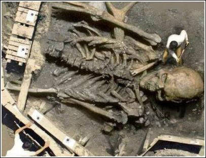
To give you a good example of what we’re talking about here, we’ll dwell for a minute on this one “photo” that is presented in many, many videos on YouTube as evidence of Giant Ancients in the world and in the desert southwest. With a little research, you’ll find that this is a doctored photo that was entered into a contest on a graphics site called Worth1000.
There are many examples of fantastic graphics manipulations on this site. HERE is the original entry.
Someone found this and used it to make bogus claims about the Ancient Giants in the desert. Of course, this may not be the case for some of the information found on the Internet. So what about the archaeologists and anthropologists and their viewpoint on this subject? If you don’t know this then it’s about time you did.
If the artefacts weren’t found by a person with a degree and documented then it doesn’t exist, period! And even if it was found by a person with a degree they are unlikely to verify it. Why, because it goes against all the verified info they have and goes against other more qualified persons.
In other words, they will be ridiculed, so they forget it or write it off as a hoax. This kind of thinking is like the dark ages but continues today in our society of scholars. Would the government acknowledge these findings? Absolutely not. Can you imagine the ramifications to follow? People with Viking backgrounds like myself who have relatives on the Isle of Man could come forth and ask for their land back or payment for it. Plus a lot of other options. So much information is censored because of this it’s no wonder we live like blind people.
Manti, Utah
Let’s look at some of the findings that may or may not support the Giant Ancients in the desert. First here is a finding in the centre of Utah near the town of Manti.

In 1955 a man by the name of John Brewer found a set of stone stairs carved on the floor of a cave near Manti, Utah. After gaining access he discovered a tomb or chamber where he found large coffins and mummies with red and blond hair of very large stature. He also found boxes with metal plates inscribed in an ancient text. He showed this to a friend, Dr Robert Heinerman, PhD in anthropology. No photos exist of the coffins or mummies. Only photos of the plates were taken. Some of the plates were made of gold, some of the copper.
It is told that Mr Brewer found other caves with more artefacts, but no more mummies. He wouldn’t show the cave to anyone else.
It has been rumoured that the LDS church may have had something to do with this decision? Of course, this may be just a rumour. So to this date, there exists no physical proof of this tale. Below is a map for reference so you’ll know where Manti, Utah is located.

Los Angeles, California
This was published in the early 1900s in the San Diego Union Newspaper. There was no follow up on this find. Did the paper just use this for a fill-in or something to boost sales of the paper? The Paiute Indians have a legend about Egyptian-like people with long dark hair that arrived here in sailing ships and made their home in Death Valley in caves near the Panamint Mountains. Could these be the same people?