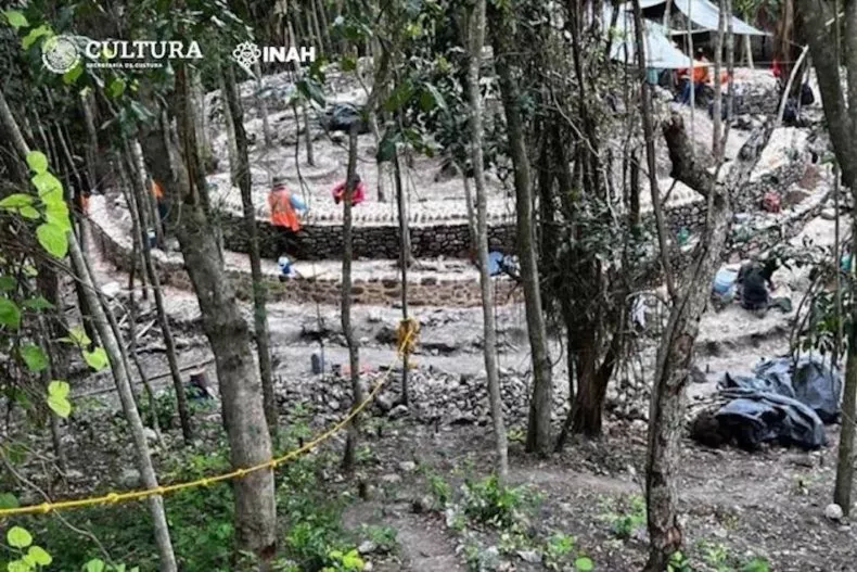
Archaeologists discover a hidden Maya burial chamber in the walled enclosure of Tulum
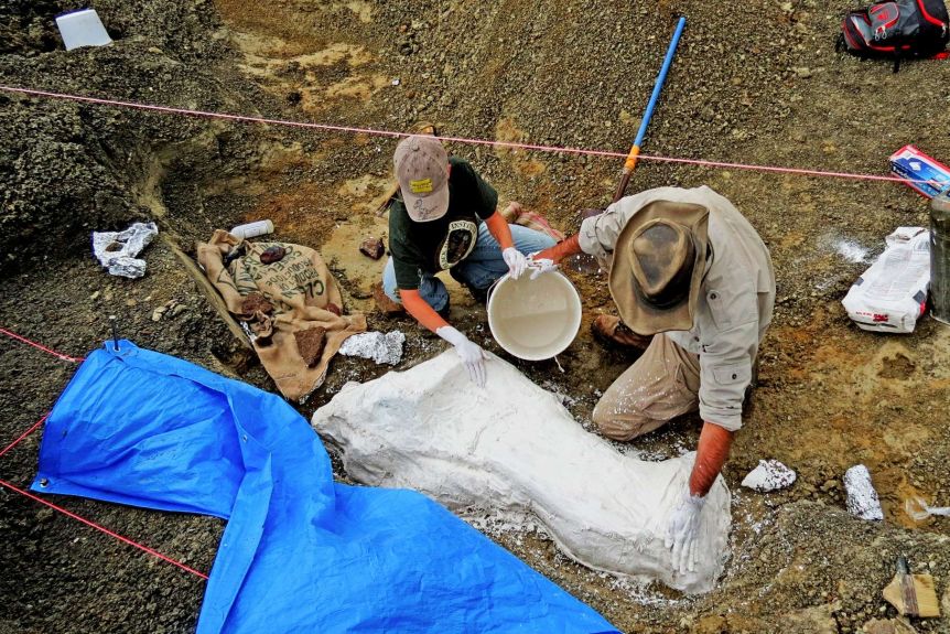
Archaeologists from the National Institute of Anthropology and History (INAH) have discovered a hidden Maya burial chamber concealed within a cave at the archaeological complex in Tulum, Quintana Roo.
The discovery, sealed off by a massive rock deep inside Mexico’s walled city of Tulum, offers a rare glimpse into the funerary practices of this pre-Hispanic civilization.
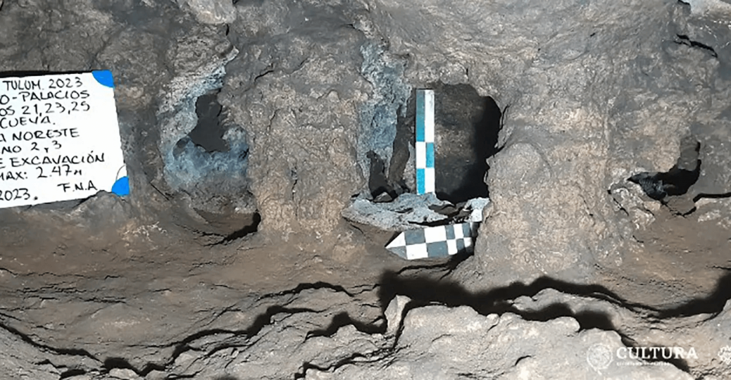
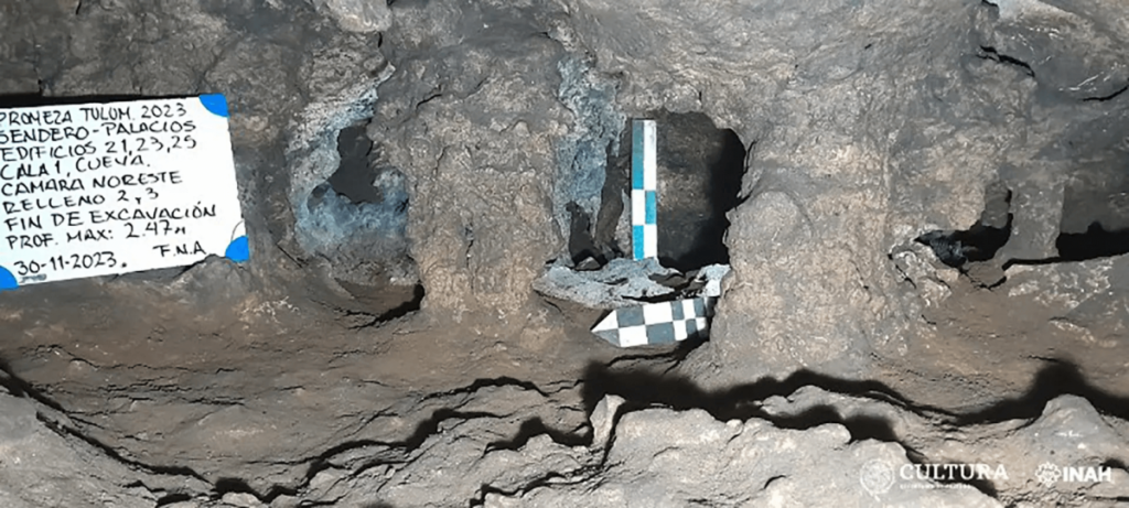
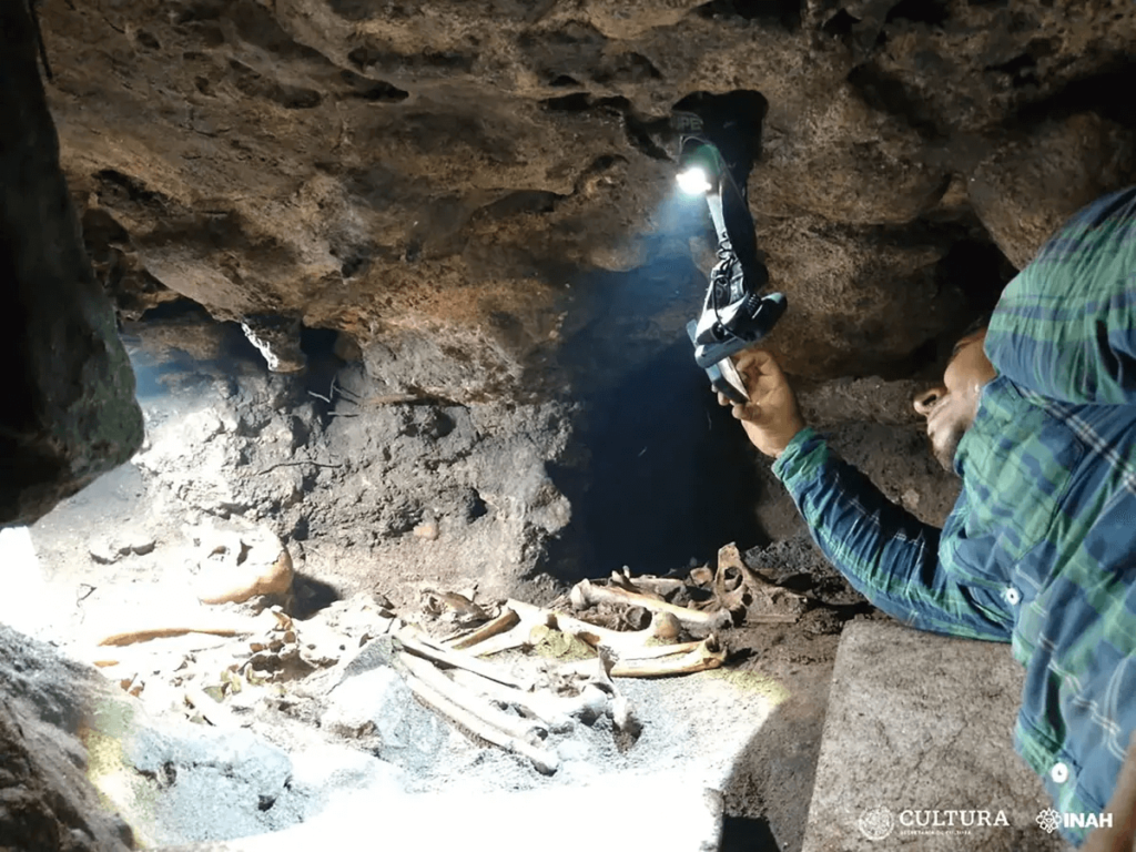
By removing a large rock blocking the entrance to a hidden cave within the walled area of the Maya city, archaeologists uncovered the skeletal remains of several individuals.
The discovery was made during routine clearing work for a new visitor path, which is nestled between two prominent temples. A meticulously glued sea snail hinted at Maya craftsmanship, while a split human skeleton hinted at a deeper secret.
Upon removing the rock that sealed the entrance to the cavity, it was observed that it was literally splitting the skeletal remains of an individual, leaving the lower part of their body outside and the upper part inside. This would indicate that the person might have become trapped while attempting to access the cavity.
The project’s coordinator José Antonio Reyes Solís said in a statement that upon removing the boulder blocking the cave’s entrance, researchers saw that it had been splitting the ossified remains of an individual, leaving the lower part of the body on the outside and the upper part inside.
An archaeologist inside the newly discovered burial site at Tulum.
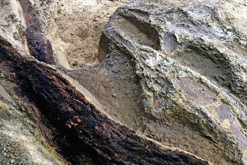
Inside the cramped cave, barely taller than half a meter, lay eight adult burials remarkably preserved by the cool, dry environment.
All materials are being studied further at INAH’s Quintana Roo Center by the head of the Department of Physical Anthropology, Allan Ortega Muñoz.
As the exploration of the cave progressed, The coordinator of the archaeological research project, José Antonio Reyes Solís said, it was identified that the topography shows at least two small chambers, located in the southern and northern parts, no more than 3 meters long by 2 meters wide, and an average height of 50 centimeters.
Likewise, a large number of skeletal remains of animals associated with the burials were recorded. According to the specialists in fauna identification, who collaborate on the project, Jerónimo Avilés and Cristian Sánchez, they correspond, in a preliminary manner, to various mammals (domestic dogs, mice, opossum, blood-sucking bats, white-tailed deer, tepezcuintle, armadillo nine banded, tapir, peccary); birds of the order Galliforme, Passeriforme, Pelecaniforme, Piciforme and Charadriiforme; reptiles (loggerhead sea turtle, land turtle and iguana); fish (tiger shark, barracuda, grouper, drum fish, puffer fish, eagle ray); crustaceans (crab and cirripedians), mollusks (snail) and amphibians (frog). Some bones have cut marks and others have been worked as artifacts, like punches, needles, or fan handles, characteristic of the area.
A single ceramic “molcajete” (grinding bowl) further pinpointed the burials to the late Postclassic period (1200-1550 AD).
In three of the burials, a small mortar of the type decorated with incisions was discovered, and it has been intervened by a restorer for preservation.
Archaeologists’ testimony describes the conditions inside the cave as particularly difficult, owing to the small entryways, low ceilings, lack of natural light, and general heat and humidity. In addition to photos, a three-dimensional scan of the area will be made so that researchers and the general public can see the materials and remains in their original context.
North America’s First People May Have Arrived By Sea Ice Highway 24,000 Years Ago
One of the hottest debates in archaeology is about how and when humans first arrived in North America. Archaeologists have traditionally argued that people walked through an ice-free corridor that briefly opened between ice sheets an estimated 13,000 years ago.
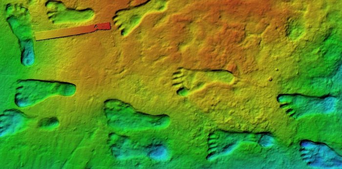
But a growing number of archaeological and genetic finds—including human footprints in New Mexico dated to around 23,000 years old—suggests that people made their way onto the continent much earlier. These early Americans likely traveled along the Pacific coastline from Beringia, the land bridge between Asia and North America that emerged during the last glacial maximum when ice sheets bound up large amounts of water causing sea levels to fall.
The idea that early Americans may have traveled along the Pacific Coast isn’t new. People were likely south of the massive ice sheets that once covered much of the continent at least 16,000 years ago.
Given that the ice-free corridor wouldn’t be open for thousands of years before these early arrivals, scientists instead proposed that people may have moved along a “kelp highway.” This theory holds that early Americans slowly traveled down into North America in boats, following the bountiful goods found in coastal waters.
Archaeologists have found evidence of coastal settlements in western Canada dating from as early as 14,000 years ago. But in 2020, researchers noted that freshwater from melting glaciers at the time may have created a strong current that would make it difficult for people to travel along the coast.
Ice highway over dangerous water
To get a fuller picture of ocean conditions during these crucial windows of human migration, Summer Praetorius of the US Geological Survey and her colleagues looked at climate proxies in ocean sediment from the coast. Most of the data came from tiny, fossilized plankton. The abundance and chemistry of these organisms help reconstruct ocean temperatures, salinity, and sea ice cover.
Praetorious’ presentation is part of a session on the climate history and geology of Beringia and the North Pacific during the Pleistocene, the current ice age, at AGU23.
The week-long conference has brought 24,000 experts from across the spectrum of Earth and space sciences to San Francisco this year and connected 3,000 online attendees.
Praetorious’ team used climate models and found that ocean currents were more than twice the strength they are today during the height of the last glacial maximum around 20,000 years ago due to glacial winds and lower sea levels. While not impossible to paddle against, these conditions would have made traveling by boat very difficult, Praetorius said.
However, the records also showed that much of the area was home to winter sea ice until around 15,000 years ago. As a cold-adapted people, “rather than having to paddle against this horrible glacial current, maybe they were using the sea ice as a platform,” Praetorius said.
Arctic people today travel along sea ice on dog sleds and snowmobiles. Early Americans may also have used the ‘sea ice highway’ to get around and hunt marine mammals, slowly making their way into North America in the process, Praetorius said. The climate data suggest conditions along the coastal route may have been conducive to migration between 24,500 and 22,000 years ago and 16,400–14,800 years ago, possibly aided by the presence of winter sea ice.
While proving that people were using sea ice to travel will be tricky, given most of the archaeological sites are underwater, the theory provides a new framework for understanding how humans may have arrived in North America without a land bridge or easy ocean travel.
And the sea ice highway isn’t mutually exclusive with other human migrations further down the line, says Praetorius. The team’s models show the Alaskan current had calmed down by 14,000 years ago, making it easier for people to travel by boat along the coast.
“Nothing is off the table,” she said. “We will always be surprised by ancient human ingenuity.”
Humans Got To America 7,000 Years Earlier Than Thought – New Research Confirms
When and how humans first settled in the Americas is a subject of considerable controversy. In the 20th century, archaeologists believed that humans reached the North American interior no earlier than around 14,000 years ago.
But our new research found something different. Our latest study supports the view that people were in America about 23,000 years ago.
The footprints come from a group of people of different ages.
The 20th-century experts thought the appearance of humans had coincided with the formation of an ice-free corridor between two immense ice sheets straddling what’s now Canada and the northern US. According to this idea, the corridor, caused by melting at the end of the last Ice Age, allowed humans to trek from Alaska into the heart of North America.
Gradually, this orthodoxy crumbled. In recent decades, dates for the earliest evidence of people have crept back from 14,000 years ago to 16,000 years ago. This is still consistent with humans only reaching the Americas as the last Ice Age was ending.
In September 2021, we published a paper in Science that dated fossil footprints uncovered in New Mexico to around 23,000 years ago—the height of the last Ice Age. They were made by a group of people passing by an ancient lake near what’s now White Sands. The discovery added 7,000 years to the record of humans on the continent, rewriting American prehistory.
If humans were in America at the height of the last Ice Age, either the ice posed few barriers to their passage, or humans had been there for much longer. Perhaps they had reached the continent during an earlier period of melting.
Our conclusions were criticized, however, we have now published evidence confirming the early dates.
Dating the pollen
For many people, the word pollen conjures up a summer of allergies, sneezing, and misery. But fossilized pollen can be a powerful scientific tool.
In our 2021 study, we carried out radiocarbon dating on common ditch grass seeds found in sediment layers above and below where the footprints were found. Radiocarbon dating is based on how a particular form—called an isotope—of carbon (carbon-14) undergoes radioactive decay in organisms that have died within the last 50,000 years.
Some researchers claimed that the radiocarbon dates in our 2021 research were too old because they were subject to something called the “hard water” effect. Water contains carbonate salts and therefore carbon. Hard water is groundwater that has been isolated from the atmosphere for some period of time, meaning that some of its carbon-14 has already undergone radioactive decay.
Common ditch grass is an aquatic plant and the critics said seeds from this plant could have consumed old water, scrambling the dates in a way that made them seem older than they were.
It’s quite right that they raised this issue. This is the way that science should proceed, with claim and counter-claim.
How did we test our claim?
Radiocarbon dating is robust and well-understood. You can date any type of organic matter in this way as long as you have enough of it. So two members of our team, Kathleen Springer and Jeff Pigati of the United States Geological Survey set out to date the pollen grains. However, pollen grains are really small, typically about 0.005 millimeters in diameter, so you need lots of them.
This posed a formidable challenge: you need thousands of them to get enough carbon to date something. In fact, you need 70,000 grains or more.
Medical science provided a remarkable solution to our conundrum. We used a technique called flow cytometry, which is more commonly used for counting and sampling individual human cells, to count and isolate fossil pollen for radiocarbon dating.
Flow cytometry uses the fluorescent properties of cells, stimulated by a laser. These cells move through a stream of liquid. Fluorescence causes a gate to open, allowing individual cells in the flow of liquid to be diverted, sampled, and concentrated.
We have pollen grains in all sediment layers between the footprints at White Sands, which allows us to date them. The key advantage of having so much pollen is that you can pick plants like pine trees that are not affected by old water. Our samples were processed to concentrate the pollen within them using flow cytometry.
After a year or more of labor-intensive and expensive laboratory work, we were rewarded with dates based on pine pollen that validated the original chronology of the footprints. They also showed that old water effects were absent at this site.
The pollen also allowed us to reconstruct vegetation that was growing when people made the footprints. We got exactly the kinds of plants we would expect to have been there during the Ice Age in New Mexico.
We also used a different dating technique called optically stimulated luminescence (OSL) as an independent check. OSL relies on the accumulation of energy within buried grains of quartz over time. This energy comes from the background radiation that’s all around us.
Colorized scanning electron microscope image of pollen grains from a variety of common plants.
The more energy we find, the older we can assume the quartz grains are. This energy is released when the quartz is exposed to light, so what you are dating is the last time the quartz grains saw sunlight.
To sample the buried quartz, you drive metal tubes into the sediment and remove them carefully to avoid exposing them to light. Taking quartz grains from the center of the tube, you expose them to light in the lab and measure the light emitted by grains. This reveals their age. The dates from OSL supported those we got using other techniques.
The humble pollen grain and some marvelous medical technology helped us confirm the dates the footprints were made, and when people reached the Americas.
7,000-Year-Old Unique Artifacts Discovered Under Melting Ice In Canada
Archaeologists have discovered dozens of unique artifacts that span more than 7,000 years in melting ice patches in British Columbia’s Mount Edziza Provincial Park, Canada.
During the survey, over 50 perishable artifacts were found near Goat Mountain and the Kitsu Plateau in Mount Edziza Provincial Park, a region that is a volcanic landscape “extremely significant” to the Tahltan, one of Canada’s indigenous First Nations.
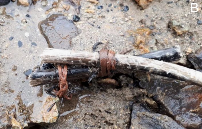
A 3,000-year-old pair of stick wrapped in animal hide found in the ice.
The finds include stitched birch bark containers, wooden walking staffs, carved and beveled sticks, an atlatl dart foreshaft, and a stitched hide boot, the research team writes in their study published in the Journal of Field Archaeology.
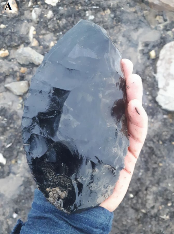
While previously exploring the area, scientists discovered many “vast obsidian quarries” and obsidian artifacts in the park.
However, the nearby ice patches had not been examined as extensively. This time, scientists wanted to find out if perishable ancient artifacts were preserved in the ice.
The study of nine ice patches led to the discovery of 56 perishable artifacts.
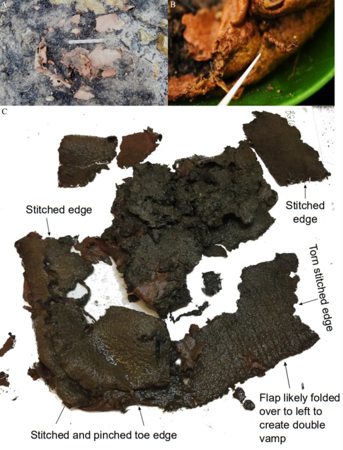
The 6,200-year-old stitched animal hide as it looked in the melting ice (A) and after unfolding (C). A close-up photo (B) shows the knotted sinew and a stitch.
One of the many obsidian artifacts found in the melting ice.
“Most of the perishable artifacts were manufactured from wood, including birch bark containers, projectile shafts, and walking staffs,” researchers said. Other artifacts were made “using animal remains include a stitched hide boot and carved antler and bone tools.”
According to a report in the Miami Herald, “Archaeologists found two bark containers with stitching.” One of these is a” 2,000-year-old piece of bark is folded with two rows of stitching along one side and some of the stitching material still left in the holes, the study said.
A 5,300-year-old antler shaped like an ice pick found in the melting ice.
The other “unique” bark container has sticks stitched into its sides, suggesting it was part of a reinforced basket used for transporting heavy loads. Researchers said it dates back over 1,400 years.”
“Archaeologists also uncovered an artifact made of stitched animal hide that they identified as the remains of a moccasin-like boot,” which is about 6,200 years old. It has “two different thicknesses of hide … which have been stitched in multiple places,” the study said.
Another intriguing object uncovered under the ice was a 5,300-year-old antler shaped like an ice pick. The research team explained the three-pronged antler had one sharpened point, one blunted as if used as a hammer, and one broken but presumed to be used as a handle.
“Every perishable artifact was found amongst a backdrop of millions of obsidian” artifacts, the study said. The artifacts were taken to a museum in British Columbia for “climate-controlled conservation” and further study.
“Radiocarbon ages on 13 of the perishable artifacts reveal that they span the last 7000 years,” the study informs.
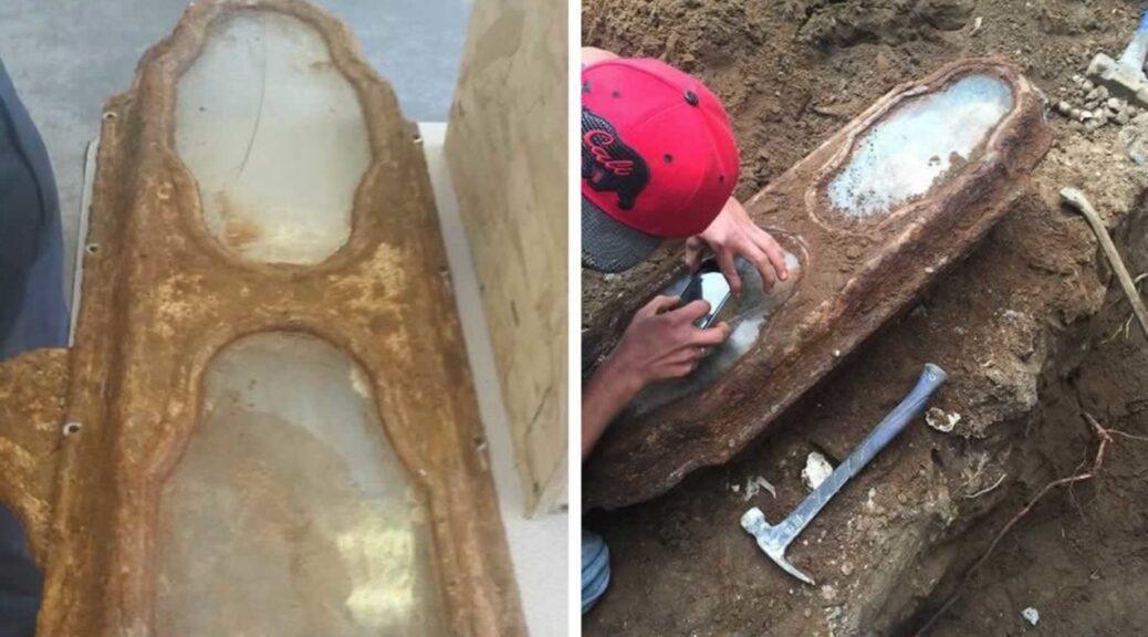
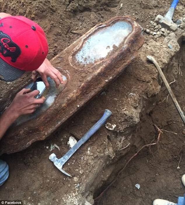
Century-Old Little Girl Found In Coffin Under San Francisco Home Identified
Researchers announced that the 19th-century body of a little girl found last year in a small metal casket under a San Francisco home was identified. The girl was Edith Howard Cook, two-year-old, who died on October 13, 1876, six weeks short of her third birthday, said the charity Garden of Innocence.
Elissa Davey, a genealogist and founder of the Garden of Innocence Project, last year arranged a reburial of the girl in Colma and began her search to identify the remains.
Scientists caught a break after hundreds of hours trying to find Edith’s identity when they discovered a map of the old cemetery at a University of California, Berkeley library, and matched it to a plot where her parents, Horatio Cook and Edith Scooffy, were once buried.
Researchers looked for living descendants once they had the family name, one of whom volunteered his DNA for research. Marin County resident Peter Cook – Edith’s grandnephew – was a match for DNA taken from strands of her hair.
UC Davis Professor Jelmer Eerkens, who helped with the DNA testing, told KTVU that Edith died of marasmus, which is severe undernourishment.
‘It’s likely she was sick with some disease and at some point her immune system couldn’t combat the disease and probably went into coma and passed away,’ he said.
Edith’s remains, found by construction workers last May, were apparently left behind when about 30,000 people originally buried in San Francisco’s Odd Fellows Cemetery in the Richmond District were moved in the 1920s to Greenlawn Memorial Park in Colma
After hundreds of hours trying to find Edith’s identity, researchers caught a break when they found a map of the old cemetery at a library and matched it to a plot where her parents, Horatio Cook and Edith Scooffy, were once buried. Pictured is her tiny casket
The girl’s well-off family gave her an ornate burial. She was clothed in a white christening dress and ankle-high boots. Tiny purple flowers were woven into her hair and she held a purple Nightshade flower in her right hand.
Roses, eucalyptus leaves and baby’s breath were placed inside the coffin, according to the Garden of Innocence report.
Edith’s father was a businessman, the report said.
Her maternal grandfather was an original member of the Society of California Pioneers, which is an organization founded by California residents who arrived before 1850.
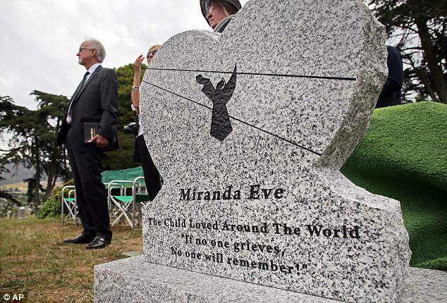
When the child was initially discovered, she was named Miranda Eve, until she was finally identified. During a reburial service last May, people from all over California came to pay their respects to Edith, whose blonde hair and skin were still perfectly preserved.
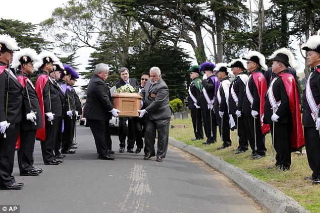
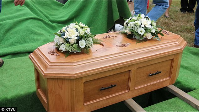
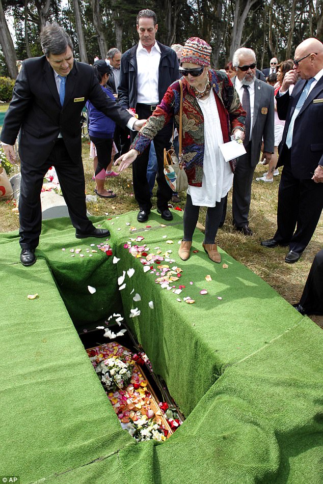
The Knights of Columbus, a Catholic based fraternal organization, dressed to the nines to carry the casket to its resting place. Four men lowered a new, cherry-wood casket into the earth as approximately 100 mourners threw flowers and petals on top.
Speakers played ‘A Trumpeter’s Lullaby’ during the 10am memorial. Michael Dunn, from the Garden of Innocence, said it was important they buried Edith because she’d been forgotten for so long.
‘She was forgotten and overlooked for more than 100 years, that ends today,’ Dunn said last year.
Garden of Innocence charity Ellisa Davey has been helping to bury the bodies of unidentified children in California for nearly 20 years. Once the child’s body was found, Davey got in touch with homeowner Ericka Karner.
During the reburial service last May, people from all over California came to pay their respects to Edith, whose blonde hair and skin were still perfectly preserved
Four men lowered a new, cherry-wood casket into the earth as approximately 100 mourners threw flowers and petals on top. Speakers played ‘A Trumpeter’s Lullaby’ during the 10 am memorial.
Several people dropped handfuls of rose petals into little Edith’s grave during the reburial last May
Davey then planned for Miranda’s reburial. ‘It was tough, very tough. But she is not just our child. She is everyone’s,’ she said.
All materials used in the funeral, including the casket, were donated.
Her headstone, in the shape of a heart, reads: ‘Miranda Eve. The Child Loved Around The World. If no one grieves, No one will remember!’
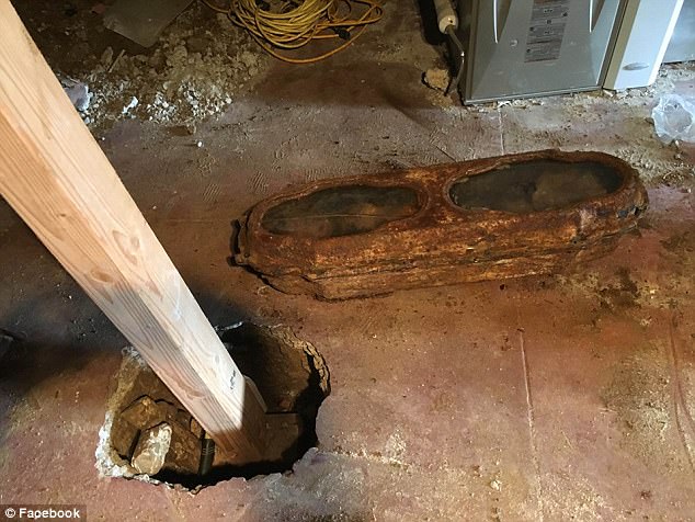
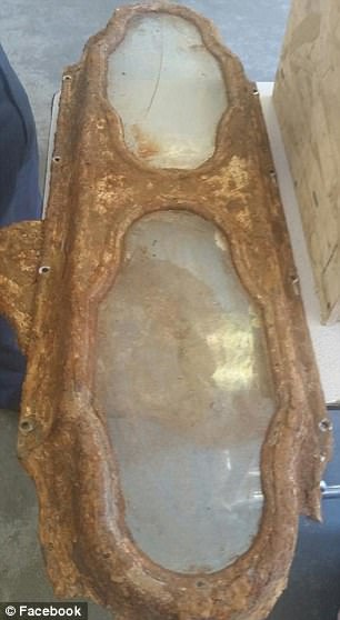
The back was made flat in case her real name was discovered. Now, since she is known as Edith, her name will be etched into the back. Construction workers were remodeling Karner’s childhood home in the Richmond District when they hit the lead and bronze coffin buried underneath the concrete garage.
The three-foot casket’s two windows revealed Edith’s perfectly preserved skin and long blonde hair. Construction worker Kevin Boylan told KTVU at the time: ‘All the hair was still there. The nails were there. There were flowers – roses, still on the child’s body. It was a sight to see.’
There were no markings on the purple velvet-lined coffin to identify the child after she was discovered on May 9, 2016.
Karner was soon surprised to find out from the medical examiner’s office that the child had become her responsibility. The city refused to take custody of Edith, and the problems continued when Karner tried to have the girl reburied. Karner was told she needed a death certificate to obtain a burial permit for the girl. A Colma undertaker was willing to take the body – for a cool $7,000.
Construction workers were remodeling Ericka Karner’s childhood home (pictured) in the Richmond District when they made the discovery
It is believed the girl was one of the 30,000 people who were buried in the city’s Odd Fellows Cemetery, which was shut in 1890. The bodies were moved to allow for redevelopment
An East Bay archaeological company’s price was even steeper at $22,000.
Meanwhile, Edith’s body was deteriorating inside her coffin in Karner’s backyard because the seal was broken after the coroner’s superior instructed him to open the casket.
‘It didn’t seem right,’ Karner told the San Francisco Chronicle last year. ‘The city decided to move all these bodies 100 years ago, and they should stand behind their decision.’
City Hall finally put Karner in touch with someone who could help, connecting her to the Garden of Innocence.
That’s when Davey, who was able to secure the funds needed to have the coffin picked up and temporarily stored in a mortuary refrigerator in Fresno, said they needed to do the ‘right thing’.
‘That girl was somebody’s child,’ she said. ‘We had to pick her up.’
It was obvious to Davey that Miranda’s parents loved her very much.
‘Just by looking at the way they dressed her,’ she wrote. ‘Their sorrow was great. We will love her too.’
Davey has been saving forgotten children since 1998, when she read a story about a baby boy who died after he was dumped in a trash can at a college campus.
A month later, the boy was still on her mind. She called up the county coroner, who told her the boy was headed for an unmarked grave if he was not claimed.
Davey asked what she could do and the coroner replied she could lay claim to the boy, as long as she proved to him she had a ‘dignified place’ to lay the child to rest, according to Inside Edition.
Since that day, Davey and Garden of Innocence has provided memorial services to nearly 300 unclaimed children. The children are all given names before they are buried with a blanket, soft toy and personalized poem in a wooden casket fitted with lace, made by the Boy Scouts. Services are sometimes attended by up to 300 people, including military members, policemen and even parents who have lost children of their own.
‘We have become a place where people find closure,’ Davey said.
And it is closure Davey wanted and received for little Edith.
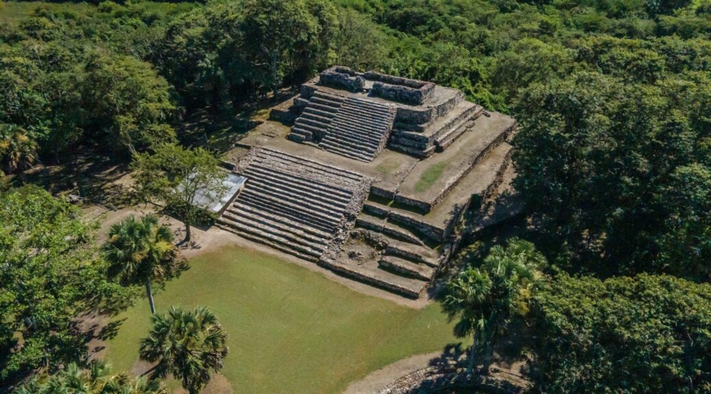
Circular Maya Structure Uncovered in Southern Mexico
Archaeologists have discovered an ancient structure in the jungles of Mexico that may have been linked to the cult of a Maya serpent deity.
A team of researchers with the Mexican National Institute of Anthropology and History (INAH) uncovered the circular structure at the archaeological site of El Tigre, Campeche State, in the Yucatán Peninsula.
El Tigre likely corresponds to an ancient Maya settlement that was known as Itzamkanac, which was a regional capital and commercial hub. The inhabitants of the region were the Chontal or Putun Maya culture, who worshipped the serpent deity Kukulcán, among other gods.
The ancient circular structure at the archaeological site of El Tigre, Campeche state, Mexico. The structure likely supported a temple dedicated to the Maya deity Kukulcán.
The El Tigre site has a long history of occupation dating back more than 2,000 years until the era of Spanish colonization began in the 16th century.
The recently discovered structure dates to the period 1000–1200 A.D. and could be linked to the cult of Kukulcán, who is equivalent to the wind god Quetzalcóatl in Aztec mythology, INAH said in a press release.
The structure, which consists of two levels, likely supported a flat-roofed temple dedicated to Kukulcán, according to archaeologists. It is similar to several other structures that have previously been found across the Yucatán at sites such as Edzná, Becán, Uxmal, and Chichen Itzá.
The importance of the structure lies in its age, which corresponds to a time when the ancient Maya settlement maintained strong ties with other regions of Mesoamerica—such as central Mexico, Oaxaca, and the Gulf Coast.
These links would have enabled the spread of religious ideas between the Chontal Maya and the other regions. For example, while the cult of Kukulcán had its origins in earlier Maya traditions, it may have also been influenced by the Quetzalcóatl cult.
An important historical document of the region known as the Paxbolón Maldonado Papers, describes a settlement called Itzamkanac that features temples dedicated to the four main deities of the Postclassic period Maya, one of whom was Kukulcán.
The latest discovery of the circular structure that potentially represents the remains of a temple dedicated to Kukulcán suggests that El Tigre is the city of Itzamkanac described in historical sources, given the site’s location and other archaeological data, according to INAH researcher Ernesto Vargas Pacheco.
“This building broadens our knowledge of the late occupation of El Tigre. Circular structures generally correspond to the early postclassic period between A.D. 1000 and 1200, when the Maya zone had links with other regions of Mesoamerica,” INAH general director Diego Prieto said at a press conference.
The structure was found during archaeological rescue works conducted as part of the Tren Maya (Maya Train) project.
The project is an almost 1,000-mile-long railway, scheduled to start operating in December. It traverses Mexico’s Yucatán Peninsula, the heart of the ancient Maya civilization, which is rich in antiquities
Tren Maya is one of the largest and most controversial infrastructure projects in the history of Mexico. It aims to bring tourists from the region’s popular beach resorts to lesser-known inland locations, including historic Mayan sites, that represent some of the poorest parts of southern Mexico.
While thousands of ancient Maya artifacts and structures have been uncovered during work on the project, critics say it places others at risk of damage or destruction, as has already occurred. Some have also raised environmental concerns.
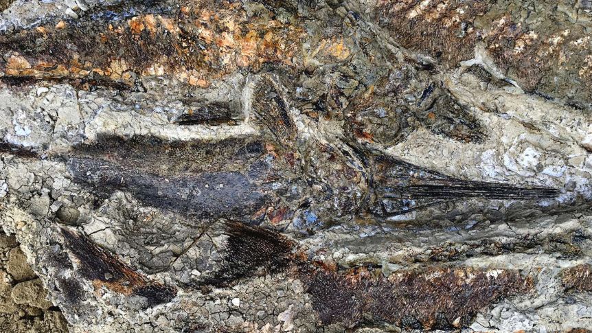
‘The day the dinosaurs died’: Fossilized snapshot of mass death found on North Dakota ranch
A fossilised snapshot of the day about 66 million years ago when an asteroid hit Earth, fire rained from the sky and the ground shook far worse than any current earthquake, is captured in new studies. It was the day that almost all life on Earth, including dinosaurs, went extinct.
The fossil discoveries add weight to the theories that a swathe of lifeforms on Earth were wiped out after an asteroid hit.
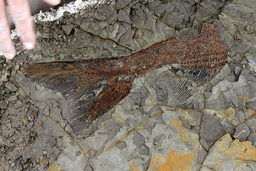
Fossil evidence discovered in Tanis, North Dakota, was revealed by the researchers, which they said dated back to the day the fatal asteroid hit, including fish with hot glass beads clogged in their gills from flaming debris that showered back on Earth.
According to a paper published by the journal Proceedings of the National Academy of Sciences, the fossilised fish graveyard reveals the sea creatures died within the first minutes or hours after the impact of the asteroid.
The researchers also reported the discovery of charred trees, evidence of an inland tsunami and melted amber.
The main author of the article, Robert DePalma, is curator of palaeontology at the Palm Beach Museum of Natural History in Florida and a doctoral student at the University of Kansas.
He told the University of Berkeley that the killing field he examined was the result of the meteor impact, which marked the end of the Cretaceous Period, also known as the KT boundary, and ended much of life on Earth.
A private fossil collector alerted Mr DePalma to the Hell Creek site in 2012.
“This is the first mass death assemblage of large organisms anyone has found associated with the KT boundary,” Mr DePalma said. Mr DePalma was first alerted to the site by a private collector in 2012.
Purdue University geophysicist and impact expert Jay Melosh, who wasn’t part of the research but edited the paper released on Friday, called it the field’s “discovery of the century”. “This is the death blow preserved at one particular site. This is just spectacular,” he said
Separately, University of Amsterdam’s Jan Smit disclosed that he and his colleagues even found dinosaur footsteps from just before their demise.
Dr Smit said the footprints — one from a plant-eating hadrosaur and the other of a meat eater, maybe a small Tyrannosaurus Rex — is “definite proof that the dinosaurs were alive and kicking at the time of impact … They were running around, chasing each other” when they were swamped.
But other experts said that while some of Mr DePalma’s work is fascinating, they have some serious concerns about the research, including the lack of access to this specific Hell Creek Formation fossil site for outside scientists.
Hell Creek — which spans Montana, both Dakotas and Wyoming — is a fossil treasure trove that includes numerous types of dinosaurs, mammals, reptiles and fish trapped in clay and stone from 65 to 70 million years ago.
Kirk Johnson, director of the Smithsonian National Museum of Natural History who also has studied the Hell Creek area for 38 years, said that the work on the fish, the glass and trees “demonstrates some of the details of what happened on the day”.
Fish form some of the different types of life that the Hell’s Creek fossil site preserved.
“That’s all quite interesting and very valid stuff,” he said. But Dr Johnson said that because there is restricted access to the site, other scientists can’t confirm the research. Dr Smit said the restrictions were to protect the site from poachers.
Dr Johnson also raised concerns about claims made by the main author, Mr DePalma, that appeared in a New Yorker magazine article published on Friday but not in the scientific paper.
However, when asked about concerns over site access, Mr DePalma told the ABC that “other researchers not on the original author list” had already been granted access to the site on multiple occasions.
“It is a fabulous and important opportunity for such collaborations, and it is essentially no different than any other major site under the custodianship of institutions other than ours,” he said.
For decades, the massive asteroid crash that caused the Chicxulub crater in Mexico’s Yucatan Peninsula has been considered the likely cause of the mass extinction. But some scientists have insisted that massive volcanic activity played a role.
Dr Johnson and Dr Melosh said this helps prove the asteroid crash case. There were only a few dinosaur fossils from that time, but the footsteps are most convincing, Dr Smit said. There was more than dinosaurs, he said.
The site includes ant nests, wasp nests, fragile preserved leaves and fish that were caught in the act of dying. He said that soon after fish die they get swollen bellies and these fossils did not show swelling.
Researchers said that the confluence of tree trunk and fish fossils point to one major extinction event.
The researchers said the inland tsunami points to a massive earthquake generated by the asteroid crash, somewhere between a magnitude 10 and 11 — stronger than the 2004 Boxing Day earthquake, found to be a magnitude 9.0 earthquake.
Purdue’s Dr Melosh said as he read the study, he kept saying “wow, wow, what a discovery”. The details coming out of this are “mind-blowing,” he said.
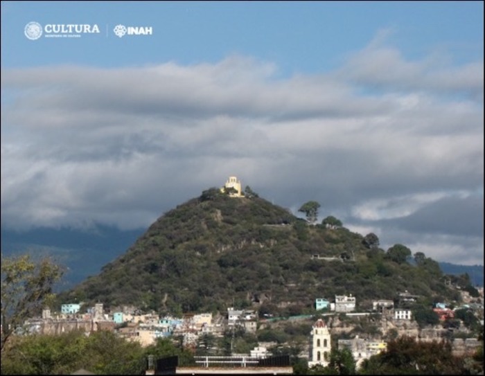
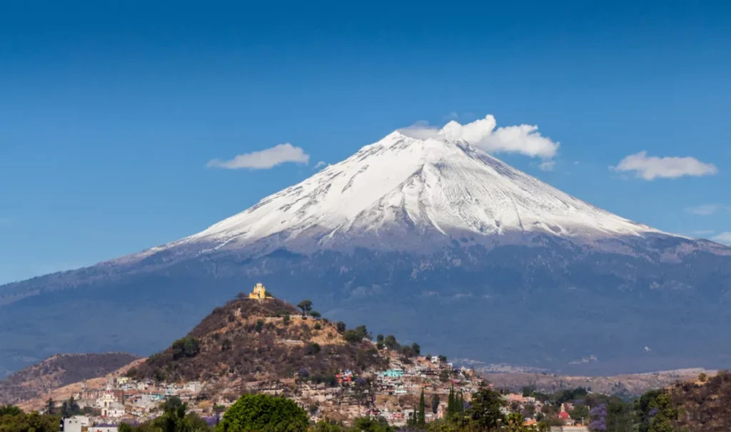
Long-Lost Temple Unearthed in the Mexican City of Atlixco
Archaeologists have found the remains of an ancient Mexican temple that was thought to be little more than a legend.
The chapel of San Miguel sits atop the hill of the same name, but this Catholic structure actually hides the remnants of a far older, legendary temple.
Within the city of Atlixco in central Mexico, there has long been a rumor of a lost temple, or teocalli, that was built centuries before the Spanish arrived in the early 16th century.
According to the local people, the Atlixquenses, the temple was originally constructed on top of the San Miguel Hill where there is currently a Catholic chapel dedicated to the archangel Michael.
Despite these rumors, no archaeological evidence for this legendary temple had ever been found.
However, recent work carried out by the Ministry of Culture of the Government of Mexico through the National Institute of Anthropology and History (INAH) has discovered vestiges that confirm its existence.
The first evidence that led to this discovery appeared during efforts to renew the chapel’s lighting and to reinforce the paths leading up the hill. A team of researchers, coordinated by INAH archaeologists Miguel Medina Jaen and Carlos Cedillo Ortego, along with Elvia Cristina Sánchez de la Barquera, found artifacts – stone tools, ornaments, and clay vessels – that were over 1,000 years old.
These objects were created by the Mesoamerican Nahua, who lived in this region centuries before Europeans arrived.
The team carried out survey work inside and around the chapel’s atrium and found the remains of stone walls and floors that had belonged to an ancient temple that pre-dates the current structure. These remnants are buried around 90 centimeters (35 inches) below the foundations of the existing chapel.
This, according to a statement released by the INAH, sufficiently affirms that “a teocalli did exist on the summit of the hill, San Miguel, and that it had at least two construction stages.”
At present, it is not clear which divinity the temple was dedicated to. Among those who may have been the focus of attention were the deities Quetzalcóatl (creator and civilizer of humanity), Tláloc (giver of rain), or Macuilxóchitl (a patron of play, dance, and festivities).
However, more research is needed before any valid conclusions can be drawn. Other “segments of the teocalli and greater clues to clarify which was its titular deity still lie under the viceregal chapel of San Miguel Arcángel,” the statement adds.
“Even with this aura of mystery, the archaeological confirmation of that ancient popular belief of more than 400 years will help strengthen the identity of the Atlixquenses.”