A Team of Archeologists Has Been Arrested in Peru for Violating Lockdown to Excavate Pre-Columbian Tombs
In Peru, an archeologist and his team of nine students were arrested for excavating on a pre-Colombian cemetery, following the national lock-up of that nation.
The group led by archeologist Pieter van Dalen was caught exploring during a state of emergency on Sunday 4 April at the Macatón Cemetery in the town of Huaral.
The team from the Regional Mayor of San Marcos University was taken into custody for breaking Peru’s extreme lock-down laws, despite claiming that they merely protected the national heritage left exposed to them in compliance with the Ministry of Culture.
Ruins in Hural in the Peruvian Andes.
The Peruvian minister of culture, Sonia Guillén, who is herself an archeologist, told local news outlet Canal N that she “deplores” the group’s actions in a time of national emergency. “It is regrettable and shameful,” Guillén said.
The archeological team had been given a permit to excavate at the archeological site about 50 miles north of the capital city of Lima, but the ministry of culture says in a statement that the permit had been “suspended” as a result of the current confinement period to protect public health, calling the subsequent breach an “irresponsible and unjustified action.”
“We call on the general population to respect all government provisions and especially to show commitment and solidarity with others,” the ministry says.
Since the lockdown was imposed on March 16, more than 51,000 people have been arrested for flouting the rules, the Peruvian president Martin Vizcarra said on Monday.
The country has so far recorded nearly 3,000 cases of the virus and more than 100 deaths since it first broke out there in March.
Image courtesy the Ministerio de Cultura del Perú on Facebook
Van Dalen defended himself to the archeology magazine Lima Gris, explaining that when the state of emergency was declared, many tombs remained open, leaving valuable funerary items exposed to the elements or thefts.
In the interview, Van Dalen also claimed that the ministry of culture was aware that the team was continuing to work on the site in order to protect national heritage.
The archeologist says that he was left “between a rock and a hard place” because he signed a letter taking responsibility for any damage to the site between February and October 2020.
“If any of the people who travel through the archeological zone every day take any of these materials or destroy them, the ministry of culture will denounce me for the destruction of cultural heritage,” he said, adding that “the ministry of culture has not developed any protocol to safeguard these materials.”
Evidence of 10,000-Year-Old Crops Points to the Amazon as an Early Agricultural Hotspot
Archaeologists have identified four independent regions where humans first started growing crops: China, the Middle East, Mesoamerica, and the Andes. We can now add Southwestern Amazon to this exclusive list, due to new evidence of plant cultivation in the region.
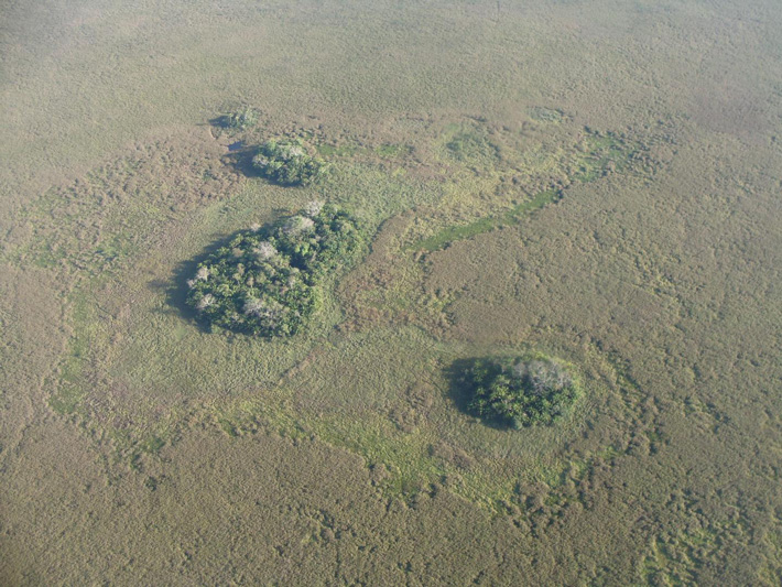
One of the 6,643 forest islands identified in the new study.
Foods made from pumpkin and cassava, a carbohydrate-rich root vegetable, were consumed in the Amazon over 10,000 years ago, according to new research published today in Nature. That’s quite a problem, just considering that four other early agricultural hotspots previously known.
At the beginning of the Holocene, and when the last ice age disappeared from the rearview mirror of mankind, rice appeared in China, grains, and legumes in the Middle East, beans and pumpkin in Mesoamerica, and potatoes and Quinoa in the Andes. The new research, led by Umberto Lombard from the University of Bern in Switzerland, points to a fifth early agricultural hot spot: southwestern Amazon, in what is now Bolivia.
“This is a very important contribution to the archeology of the Amazon and South America,” said Jennifer Watling, a microbotanist and archaeologist from the University of São Paulo who was not involved in the new study. It has long been debated whether the first people who inhabited the humid tropics already knew how to grow plants. This study provides on-site evidence that they have done that, at least in southwest Amazon, “she told Gizmodo.
The new evidence shows that some of the first people to arrive in the Amazon quickly took advantage of the natural resources available to them. Scientists aren’t entirely sure when humans first migrated to South America, but archaeological evidence suggests it was one as long 14,600 to 15,600 years ago. That person settled in the Amazon 10,000 years ago is hardly a stretch.
The new evidence was found in Llanos de Moxos, an Amazonian savanna in northeastern Bolivia. Covering an area of 126,000 square kilometers (48,700 square miles), Llanos de Moxos is peppered with unusual features all of which potential evidence of prehistoric human activity, including elevated fields, mounds, canals, and forest islands. These ‘islands’ are small, slightly elevated areas with dense tree growth around them through plains. For the new study, Lombard and his colleagues focused on the forest islands, looking for signs of early cultivation.
Using remote sensing tools, the team brought the Surface from above and identified 6,643 individual forest islands ranging in size from 0.05 hectares to 16 hectares (0.12 to 40 hectares). Of these, 30 were examined up close, in an archaeological technique known as an earthwork. These personal investigations revealed that many of these forest islands were likely former agricultural sites.
At these locations, the scientists dug and dug up sedimentary nuclei for analysis. This allowed them to perform carbon dating but it also gave access to phytoliths – silica-based particles that form in plants. The nice thing about phytolites is that they are formed according to the specific plant species in which they were formed, allowing the researchers to identify the exact crops on these forest islands.
First author Umberto Lombardo investigating sediment cores in the Llanos de Moxos.
“Although only 30 of the 6,643 forest plots were analyzed for phytolites, this study represents one of the most comprehensive landscape-scale reconstructions of previous Amazon land use and subsistence strategies.” paleoecologist S. Yoshi Maezumi, an honorary researcher from the University of Exeter, said Gizmodo.
“The consistent presence of a variety of domesticated crops in these soil profiles supports the interpretation that the forest islands were probably landscaped and used as home gardens,” said Maezumi, who was not involved with the new research.
In particular, the researchers also found evidence of cassava called manioc, pumpkin, and early corn. The cassava was dated 10,350 years ago, the pumpkin 10,250 years ago and the corn 6,850 years ago.
These carbohydrate-rich staples were likely supplemented with large herbivores and fish in the savannas, according to the research team, including scientists from Penn State University, the University of Exeter, and Pompeu Fabra University, among other institutions.
“We already knew from genetic studies that cassava was domesticated somewhere between 8,000 and 10,000 years ago, so it’s the most surprising evidence,” said Maezumi. “The fact that humans cultivated a domesticated pumpkin species 10,000 years ago implies an even earlier period of pre-domestication cultivation, and it will be extremely interesting to know where this took place.”
Interestingly, the new study also shows that early settlers in the Southwest Amazon were not exclusively hunter-gatherers because they adopted an agricultural lifestyle.
Maezumi said there are still many unanswered questions about these early pursuits, such as the size of these groups, whether the forest islands were in fact gardens and where these people actually lived.
The new study “places the southwestern Amazon as one of the oldest domestication centers in the world,” Watling told Gizmodo. The evidence adds “to a growing body of evidence that the Southwest Amazon was a hotspot for early human habitation and provides new insights into how people lived and used diverse resources” in the forest and savanna ecosystem. The diverse landscape, she said, has likely played a key role in the process of plant domestication.
“As this region is currently under threat from deforestation and unsustainable land use, these data establish the antiquity of human land use in the area and provide an example of more than 10,000 years of indigenous land use, plant cultivation and livelihood strategies that can sustainably inform Futures from the Amazon, ”said Watling.
“As this region is currently under threat from deforestation and unsustainable land use, these data establish the antiquity of human land use in the area and provide an example of more than 10,000 years of indigenous land use, plant cultivation and livelihood strategies that can sustainably inform Futures from the Amazon, ”said Watling.
It is the legend that drew legions of explorers and adventurers to their deaths: an ancient empire of citadels and treasure hidden deep in the Amazon jungle.
Spanish conquistadores ventured into the rainforest seeking fortune, followed over the centuries by others convinced they would find a lost civilization to rival the Aztecs and Incas.
Some seekers called it El Dorado, others the City of Z. But the jungle swallowed them and nothing was found, prompting the rest of the world to call it a myth. The Amazon was too inhospitable, said 20th-century scholars, to permit large human settlements.
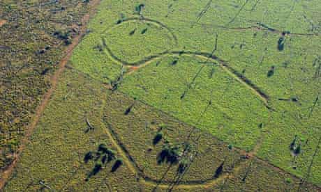
Now, however, the doomed dreamers have been proved right: there was a great civilization. New satellite imagery and fly-overs have revealed more than 200 huge geometric earthworks carved in the upper Amazon basin near Brazil’s border with Bolivia.
An aerial picture of traces of earthworks built by a lost Amazonian civilization dating to 200AD.
Spanning 155 miles, the circles, squares and other geometric shapes form a network of avenues, ditches, and enclosures built long before Christopher Columbus set foot in the new world. Some date to as early as 200 AD, others to 1283.
Scientists who have mapped the earthworks believe there may be another 2,000 structures beneath the jungle canopy, vestiges of vanished societies.
The structures, many of which have been revealed by the clearance of forest for agriculture, point to a “sophisticated pre-Columbian monument-building society”, says the journal Antiquity, which has published the research.
The article adds: “This hitherto unknown person constructed earthworks of precise geometric plan connected by straight orthogonal roads. The ‘geoglyph culture’ stretches over a region more than 250km across, and exploits both the floodplains and the uplands … we have so far seen no more than a tenth of it.”
The structures were created by a network of trenches about 36ft (nearly 11 meters) wide and several feet deep, lined by banks up to 3ft high. Some were ringed by low mounds containing ceramics, charcoal and stone tools. It is thought they were used for fortifications, homes, and ceremonies, and could have maintained a population of 60,000 – more people than in many medieval European cities.
The discoveries have demolished ideas that soils in the upper Amazon were too poor to support extensive agriculture, says Denise Schaan, a co-author of the study and anthropologist at the Federal University of Pará, in Belém, Brazil. She told National Geographic: “We found this picture is wrong. And there is a lot more to discover in these places, it’s never-ending. Every week we find new structures.”
Many of the mounds were symmetrical and slanted to the north, prompting theories that they had astronomical significance.
Researchers were especially surprised that earthworks in floodplains and uplands were of a similar style, suggesting they were all built by the same culture.
“In Amazonian archaeology, you always have this idea that you find different peoples in different ecosystems,” said Schaan. “So it was odd to have a culture that would take advantage of different ecosystems and expand over such a large region.”
The first geometric shapes were spotted in 1999 but it is only now, as satellite imagery and felling reveal sites, that the scale of the settlements is becoming clear. Some anthropologists say the feat, requiring sophisticated engineering, canals, and roads, rivals Egypt’s pyramids.
The findings follow separate discoveries further south, in the Xingu region, of interconnected villages known as “garden cities”. Dating between 800 and 1600, they included houses, moats, and palisades.
“These revelations are exploding our perceptions of what the Americas really looked liked before the arrival of Christopher Columbus,” said David Grann, author of The Lost City of Z, a book about an attempt in the 1920s to find signs of Amazonian civilizations. “The discoveries are challenging long-held assumptions about the Amazon as a Hobbesian place where only small primitive tribes could ever have existed, and about the limits the environment placed on the rise of early civilizations.”
They are also vindicating, said Grann, Percy Fawcett, the explorer who partly inspired Conan Doyle’s book The Lost World. Fawcett led an expedition to find the City of Z but the party vanished, bequeathing a mystery.
Many scientists saw the jungle as too harsh to sustain anything but small nomadic tribes. Now it seems the conquistadores who spoke of “cities that glistened in white” were telling the truth. They, however, probably also introduced the diseases that wiped out the native people, leaving the jungle to claim – and hide – all trace of their civilization.
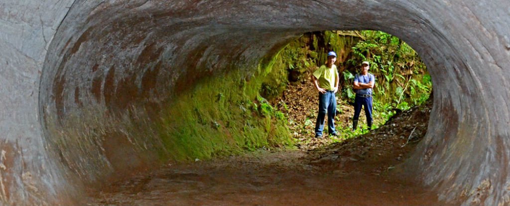
Hundreds of tunnels which date back at least 10,000 Years have been Discovered in Brazil
Research teams in South America have found many gigantic burrows that are so massive and neatly constructed that you’d be forgiven for thinking humans dug them as a passageway through the forest.
The structure was huge, and according to Jenner, it’s still the largest known palaeoburrow in the Amazon and is twice the size of the second-largest palaeburrow in Brazil.
They are much older than they seem, they are estimated to be at least 8,000 to 10,000 years old, and they can not be explained by any known geological process. But then there are the massive claw marks lining the walls and the ceilings
Throughout Brazil, you can find the iconic statue of Christ the Redeemer and the awe-inspiring mountains of Corcovado and Sugarloaf. Travelers and adventurers will find in the country a magnificent slate of fauna like the giant anteater, many types of sloths, armadillos, otters, and even capybara in the country. However, Brazil has more than meets the eye. In fact, the country has its fair share of mysteries.
In 2010, geologist Amilcar Adamy from the Federal University of Rio Grande do Sul, found a giant hole a few miles north of the Bolivian border. Upon investigation, he realized that the hole could not have been naturally made. None of the caves Adamy explored looked like anything the tunnels featured, with their round passages and smooth floors.
The mysterious tunnels have since then been discovered by various experts around the country and have opened up an entirely new realm of possibilities for geological studies.
Geologist Heinrich Theodor Frank stumbled across the tunnels while driving on the national Novo Hamburgo Highway. While driving, a hole of around one meter in diameter caught his attention. The hole was located at a construction site, and after further investigation, Frank discovered that the hole led to a complex underground tunnel. The tunnel was about 70 centimeters high and a few meters in length, with what appeared to be strange scratches on the ceiling of its walls.
After further exploration, Frank realized that hundreds of similar tunnels existed all over Brazil. The state of Rondonia alone has a large complex of 600 meter-long tunnels. Not only that, but 2,000 burrows with similar characteristics have also been found. Not even the locals in the area knew about the origins of the tunnels. Further tests showed that the tunnels were not man-made in origin.
Urban legends point towards various “historical” and even supposed “mythological” origins of the mysterious tunnels. Some say the tunnels were created by Indians, Jesuits, slaves, or even revolutionaries. Others believe the tunnels are a giant anthill or were even made by bears. Very rare few points towards a great mythological serpent that may have used the tunnel as its home.
Regardless, geological evidence alone proves that the tunnels were not created by Brazilian natives. The Indians who lived in Brazil even before the Europeans arrived did not use iron, and therefore had no means of digging through the hard rocks around the tunnels.
According to Frank, there is no natural geological process known to man that can produce the features of the tunnels. These features include the circular or elliptical cross-sections that branch, rise, and fall around the area. The geographic distribution of the tunnels is another mystery to scientists. The tunnels were only found in the southern parts of Brazil – particularly in the states of Rio Grande do Sul and Santa Catarina. They don’t exist anywhere else.
The claw marks on the walls of the tunnels are also peculiar. Prehistoric animals such as giant armadillos or possibly mega-sloths are thought by many to be possible creators of such marks. The biggest burrows, with sizes of up to five feet in diameter, may have been dug by ground sloths that have adapted to the area’s environment and developed digging skills.
Giant armadillos, though shorter than sloths, may also have the skills necessary to dig these tunnels as well. The grooves along the ceiling may, in fact, be marks the animals have left whenever they pause or stop working. Unfortunately, there are no specific indications of these animals living in the country. Moreover, the sheer size of the tunnels cannot possibly be made by any “giant” armadillos or sloths – at least, ones that we know of.
The giant armadillo, the largest existing member of its family, weighs between 65 and 90 pounds and is native to South America. However, its burrows are about 16 inches in diameter, and only up to 20 feet long. If the tunnels’ five foot wide and 250-feet long burrows are in fact dug my animals, then it should be one extremely big creature – one that has not been discovered yet. However, it seems there is still another possibility.
Frank eventually sent photographs of the tunnels to Marcelo Rasteiro of the Brazilian Society of Speleology. He introduced the notion of “paleoburrows” excavated by living organisms in any geological age.
Examples of these organisms include worms in the Cambrian Era, mollusks in the Mesozoic Era, or rats in the Pleistocene. These are all organisms that have lived millions of years ago. Until the early 2000s, hardly any burrows attributed to extinct animals can be found in the scientific literature. In fact, it was only in 2015 that Adamy himself had the opportunity to extensively explore the mysterious tunnels.
If this paleoburrow theory is to be believed, then the tunnels in Brazil may have been created between 10,000 and 8,000 years ago. If this is the case, then the Rondonia tunnels Frank has discovered may be the first – and the largest – paleoburrow in the Amazon. These tunnels can actually be found all over the world, which adds even more depth to the mystery. Frank said similar caves could be found in countries such as Uruguay, Paraguay, Chile, Bolivia, and Argentina.
Until scientists can figure out who, what, or how these paleoburrows were made, they will remain an unfathomable enigma.
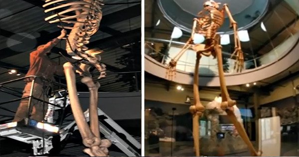
Ecuador Expose the Skeletons of an Ancient Race of Giant Humans – 7 Times Bigger Than Modern Humans
According to a research team led by British anthropologist Russell Dement, strikingly tall skeletons uncovered in the Amazon region of Ecuador and Peru are undergoing examination in Germany. Will these remains prove that a race of tall people existed deep in the Amazon rainforest hundreds of years ago?
By gum! Scientists find new 110-million-year-old treasure
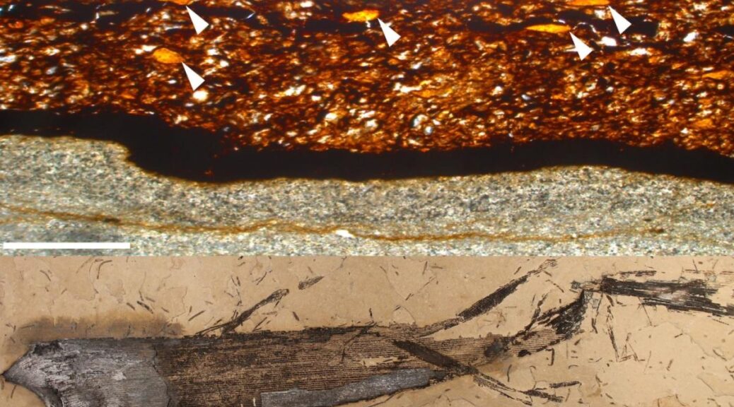
During the analysis, scientists from the University of Portsmouth, examining fossilized leaves of the Welwitschiophyllum plant found in the Crato Formation in Brazil, have discovered a remarkable new treasure- the first fossil plant gum on record- ‘Welwitschiophyllum.’
Researchers have noticed that thin amber-colored bands locked inside some of the fossilized leaves. The beautiful, amber-like material has been discovered in 110 million-year-old fossilized leaves.
Unlike amber, which is made from fossilized plant resin, this newly discovered material is made from fossilized plant gum.
The fossilized leaves belonging to the Welwitschiophyllum plant.
A wide variety of vascular plants produce fluid exudates e.g., resins and gums, with each group differing in chemical definitions.
Due to similarity in physical appearance, distinguishing exudates based on chemistry is vital; for example, gums and resins are visually similar, resulting in these terms being used interchangeably.
The study was conducted in collaboration between the University of Portsmouth, the University of Vienna (with amber expert Dr. Leyla Seyfullah), and the British Library (with FTIR (Fourier Transform Infrared Spectroscopy) specialist Dr. Paul Garside).
University of Portsmouth Ph.D. student Emily Roberts said, “This discovery overturns the basic assumption that plant gums cannot be preserved in the fossil record. It has opened our eyes to the fact that other plant chemicals may also be preserved—we can no longer make assumptions.
When we first tested the gum, I was astonished that we were confirming something that was thought to be impossible—it just goes to show that fossil plants can surprise us.”
According to the study, the Welwitschiophyllum plant is considered to be related to one of the oldest and most enigmatic plants in existence.
Remarkably, a considered relative of this plant is still growing today, Welwitschia is the sole survivor of this lineage and is now found only in the Namib Desert in Namibia and Southern Angola.
The fossil gum in a thin section of the fossilized leaf.
Co-author Professor David Martill, of the School of the Environmental Geography and Geosciences at the University of Portsmouth, said: “Emily has not only discovered something ground-breaking about plant gum but perhaps, even more, astonishing her findings confirm that the Welwitschia plant found in Africa today produces a gum similar to a plant growing 110 million years ago in Brazil.
Welwitschia is one of life’s survivors, thriving in one of the harshest environments on earth for over 120 million years.
This discovery is fascinating, especially when put into the context of these two continents of Africa and South America, being one during the Cretaceous period.”
Scientists suggest there is still much to be learned and that future work should focus on how this preserved gum has survived 110 million years.
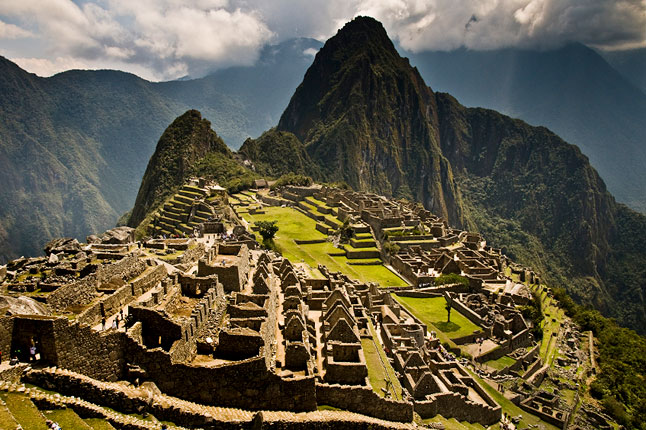
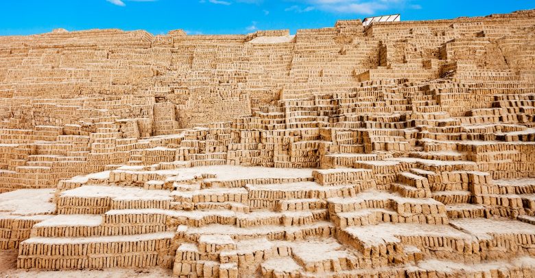
The Huaca Pucllana: A Massive Ancient Pyramid You Probably Never Knew Existed
Lima, Peru is home to many wonders of the world including the Huaca Pucllana pyramid. Huaca Pucllana served as an administrative and ceremonial center in the pre-Inca Lima culture to elite clergymen. Today, Huaca Pucllana now offers its visitors a glimpse into the history of the ancient culture.
About Huaca Pucllana
The Huaca Pucllana is an adobe and clay pyramid located in the Miraflores district in centralized Lima, Peru. The pyramid has seven staggered levels.
The inhabitants of the area who built the pyramid lived 200 AD to 700 AD. Huaca Pucllana itself, however, was built around 500 AD. The process of uncovering Huaca Pucllana began in 1981 and in 1991 it became a historical and cultural park.
The pyramid once served as an important ceremonial and administrative center for the Lima Culture in the region. There is a plaza that surrounds the structure and a large wall dividing it into separate sections. A section of the plaza has benches and deep pits. Inside of this section is where they would perform ceremonies as well as make their sacrifices and offerings.
Another area of the plaza had an administrative section. Various small clay and adobe huts were once located inside the enclosure. You can find the intact remains of the “Señor de los Unkus” (The Lord of the Unkus). His remains were uncovered and are located in one of the tombs on the site.
The ancient civilization responsible for building the massive pyramid was notable for its architectural style, engineering skill as well as their mastery of irrigation which eventually led them to spread across a considerable amount of territory.
Surrounded by a vast desert, the ancient culture created intricate irrigation networks that allowed them to transport water from springs and rivers to their settlements.
The Pyramid, just as the Huaca del Sol and Huaca de la Luna, was built using adobe bricks. Millions of Adobe bricks.
In 1991, the Peruvian Cultural Institute and the Municipality of Miraflores signed an agreement in 1991 that allowed the Huaca Pucllana pyramid to become a historical and cultural park in the city.
It is believed that the site where the pyramid is located was home to a number of smaller pyramids and plazas. The smaller structures are thought to have grown over time, as each new generation added to them.
The administrative center of Huaca Pucllana was composed of several patios, platforms and storage facilities. Scholars argue that the pyramid was mostly used as an administrative site for the irrigation zone of the city.
The entire pyramid complex is divided by a large wall that was built running from north to south. The site was also home to spaces that were most likely used by the ancients as meeting spots, storage rooms, and other production-related activities.
The western part was the religious center and is home to the pyramid which rises a towering 22 meters into the air. The Pyramid which is more than 400 meters wide was built with adobe bricks stacked horizontally on top of each other.
The pyramid, much smaller in size compared to the Great Pyramid of Giza was nonetheless a tremendous engineering feat of ancient times. The pyramid was most likely visible from several miles away when it was complete, some 1,500 years ago.
Today, it stands as evidence of the ingenuity and architectural complexity of pre-Columbian civilizations and developed cultures inhabiting the American continent long before the Europeans set foot on the New Continent.
The entire site shows the rich history of the region, spanning back to a time long before the Inca rule of the region.
Looking back at its size, complexity, and history, one cannot help but stand awestruck by the Pyramid’s irradiating beauty which in many images looks almost as if it was built by Minecraft builders in the real world.
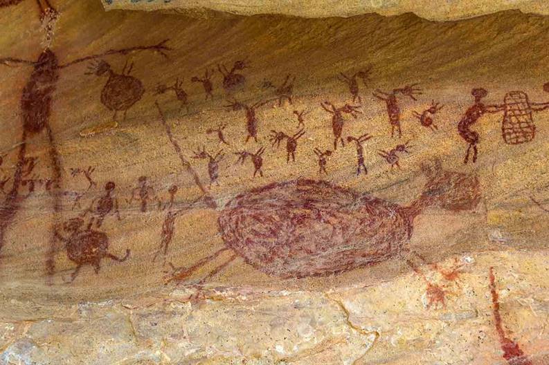
Humans Present at Brazil’s Santa Elina Rock Shelter 23,120 Years Ago, Confirms National Museum of Natural History in Paris
Exact Bone Dating by researchers in the Paris National Museum of Natural History. Details of the new date have been published in a paper in the scientific journal Antiquity of Cambridge University, where the research team places modern people far before the 20,000 years ago in the rock shelter of Santa Elina in Brazil.
Santa Elina rock shelter excavation site above left and sloth bone ornaments with drilled holes above right.
The rock shelter of Santa Elina in central Brazil contains remarkable rock art and confirmation of the first Americans ‘ lengthy occupation.
Humans Present at Brazil’s Santa Elina Rock Shelter 23,120 Years Ago, Confirms National Museum of Natural History in Paris
Occupation of the site is dated to several different periods, suggesting that groups of hunter-gatherers only dwelt at the site when climate favoured hunting in the region. The irregular periods of occupation spread across the Late Pleistocene and Late Holocene.
For many years now teams of archaeologists investigating ancient human occupations sites across Brazil have produced evidence of extremely early colonisation of this part of South America.
The earliest dates associated with Brazilian archaeological research are close to 60,000 years ago. However such extreme figures for colonisation remain highly controversial.
Excavations carried out at the Santa Elina rock shelter between 1984 and 2004 explored three sediment layers containing the remains of hearths, stone artefacts and bones associated with the extinct giant sloth species Glossotherium.
Several of the bony plates from the sloth skin had been converted into ornaments of some kind by the resident humans, the added notches and holes may have allowed these plates to be worn on the body.
Glossotherium, like other giant ground sloths, was a herbivore. It was 13 ft (4m) and weighed 2210 lbs. It would have been one of the largest herbivores in South America. This species became extinct around 12,000 years ago.
Scientists utilised three separate dating methods to investigate samples of charcoal, sediment and the sloth bones. The revealed dates securely place people at the Santa Elina site well over 23,120 years ago. Humans groups abandoned the site after a short period, but later groups utilised the rock shelter again between 10,120 to 2,000 years ago.
The new dates from Santa Elina further erode the consensus understanding that the first modern humans, known as the Clovis people, reached the Americas by walking across a land bridge between Northeast Asia and North America just 13,000 years ago.
In recent years a steady series of archaeological finds have caused a growing number of archaeologists to abandon the ‘Clovis first’ colonisation model.
The evidence of hunter-gatherers living in the Santa Elina rock shelter 23,120 years ago is highly problematic for scientists that still believe humans reached the Americas by walking into North America – the rock shelter is over 12,000 kilometres from the proposed entry site.
Not only is Santa Elina far from the earliest Clovis sites, but it is also over 2000km from the coast in a heavily forested region.
These facts call into question the way in which the American continent was colonised as it is logical to suspect that humans lived along the coastline long before making the arduous journey into the Brazilian interior 23,120 years ago.
A growing number of researchers suspect that the first settlers used canoes to colonise the Americas and perhaps drifted down the Pacific Coast in simple watercraft before heading inland.
Some South American sites once occupied by Stone Age people are closer to the Atlantic coast, raising the possibility of the first colonisation involving a movement of people from Africa.