“My wife and I walk the beach almost every day,” Mark O’Donoghue said. Saturday he spotted “some timbers and metal spikes,” exposed in the sand.
Sunday, even more, had been exposed and he had a hunch that it was a shipwreck. Part of the ship was poking through the sand.
He notified the Lighthouse Archaeological Maritime Program, and they told him he was right.
Archaeologists were out Sunday and Monday, documenting the site in Crescent Beach, just north of the Matanzas Inlet. They believe the ship is from the 19th century, based on its construction and the frequency of ships wrecking on the northeast Florida coast during the 1800s.
A 200-year-old shipwreck was discovered on Crescent Beach in Florida. Archaeologists have said that it was most likely a cargo ship about the size of a semi-truck.
Archaeologist Chuck Meide stood near the middle of the exposed wooden beams in the sand and said, “If I were standing on this ship when it was a living ship, I would be in the cargo hold, standing on the very bottom. So this would be the floor of the cargo hold.
“This is the centre line of the vessel,” he said, pointing with his foot, “so the bottom of the hull would be here and then over my head is going be the deck.”
Pat Lee lives in the condos, on the dune just above the shipwreck. He told First Coast News that no one knew there was a ship buried here until erosion started ripping away the beach.
“The wreckage there used to be under 10 feet of sand. In the last three years, we lost it. We lost it all,” Lee said.
“It’s very cool to see the shipwreck. It is very disturbing to see the sand leave our beach,” he added.
Of course, beaches change over time. Just as this coastline is experiencing erosion now, at one point, sand accumulated along this beach.
Meide said, “The sand dune wasn’t here when the shipwrecked. We know topography and the landscape of a coast changes a lot.”
When the ship did get pushed far onto the beach, possibly by a storm, Meide speculated, sand formed around it — sealing in its secrets until now.
And for at least a year, O’donoghue was walking right by a shipwreck!
Another Possible Lost Cemetery Site Found in Florida
An investigation into the whereabouts of a segregation-era lost cemetery has found possible burial sites with ground-penetrating radar on MacDill Air Force Base property, according to a report in The Tampa Bay Times.
This would be the fifth lost cemetery found in the Tampa Bay area over the last 16 months. The Port Tampa Cemetery for Blacks was once near the corner of Interbay Boulevard and Manhattan Avenue. That land is now part of the base. The cemetery disappeared around the time the base opened in 1941.
There are no known records of the at least 38 bodies buried there being moved. Archaeologists began looking for the cemetery earlier this year and their report was sent to MacDill on Friday.
The red square indicates where possible graves from the Port Tampa Cemetery for Blacks were discovered on MacDill Air Force Base.
NAACP Hillsborough County Branch President Yvette Lewis also received a copy of the report. She shared it with the Tampa Bay Times. MacDill has not yet replied to a Times request for comment via email. Voicemail to a base spokesman did not pick up.
A report on Tampa cemeteries — written in the 1930s but issued in 1941 by the federal Works Progress Administration — said the Port Tampa Cemetery could be reached by starting at the corner of Interbay Boulevard and Manhattan Avenue, heading south 884 feet, turning east and going 1,327 feet.
Ground-penetrating radar in that area “identified anomalies as possible burials,” the archaeological report provided by the NAACP said. “While these anomalies were not clustered or arranged in patterns typically seen in historic cemeteries, their spacing is consistent with the use of an area as an expedient informal burial ground, where intermittent burials took place and where individual burials would not be in family groups or arranged in obvious rows.”
According to that report, there are four other areas where the cemetery could have been located:
• Immediately west of where the radar discovered grave-like anomalies. That spot is suspect because aerial maps from 1938 show it as a cleared square area.
• A 45-acre “wooded area in the northwestern area” of the base near where the radar possibly found graves. Because the archaeologists could not confirm the cemetery’s boundaries, the archaeologists recommend the “wooded tract be treated with caution in the event that human remains may be present.”
Archaeologists investigated each of those other areas with radar and dogs that can sniff human remains but found no evidence of burials. Still, those areas should be considered “sensitive,” the report read, and any work that could disturb possible graves should be avoided.
Overall, the report said, the archaeologists found obituaries and death certificates for 38 people buried in the cemetery. That included 12 stillborn infants.
The Works Progress Administration report stated it was a Black cemetery, but archaeologists did find one death record for a white burial.
The base suggests erecting a marker near Dale Mabry Gate that will honour the cemetery, according to an email from MacDill to the NAACP that Lewis also shared with the Times.
“Be it known that this plaque serves as a memorial to those dearly departed love ones who are believed to be buried on MacDill AFB at what was known as the Port Tampa Cemetery,” is suggested language for the marker.
It would also include this quote from Hillsborough County Judge Lisa D. Campbell, whose maternal grandparents buried a stillborn in the cemetery: “Through the curtain of time, we find you here, in infinite peace. We call your name and you answer in legacy and honour. Rest. Eternally.”
Port Tampa was established in the 1890s as a separate city. African Americans moved there for the jobs at the port, but they dried up once Port Tampa Bay opened to the east in the mid-1920s.
MacDill opened in 1941 and Port Tampa was annexed by the city of Tampa in 1961.
Graves from four other cemeteries have been discovered in the Tampa Bay area over the last 18 months — two in Tampa and two in Clearwater. Three of those were for Blacks. The fourth, Ridgewood Cemetery found on Tampa’s King High School campus, was for the indigent and unknown, but records indicate nearly all the burials Black.
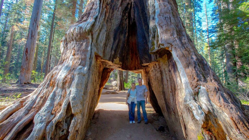
The Pioneer cabin tree older than 1,000 years has fallen after a violent storm that hit California
After getting the news, it feels like the end of an age, the iconic Sequoia ‘ Tunnel Tree ‘ has gone down in history as a violent storm that struck California brought it to the Ground.
The Tunnel Tree was part of the Calaveras Big Trees State and was counted among the most famous trees across the United States. For over a century, it enchanted the hearts of the park’s visitors.
It is estimated that the gigantic tree was older than 1,000 years and measured 10 meters in diameter.
A California state park ranger
“The Pioneer Cabin Tree has fallen! This iconic and still living tree – the tunnel tree – enchanted many visitors.
The storm was just too much for it,” reads a status update at The Calaveras Big Trees Association’s page on Facebook. The Sequoia tree was grandeur, which allowed it to claim such an iconic status.
Reports suggest that in the past couple of years, the tree was barely alive, having only one branch alive at the top.
The storm which is considered to be the strongest one to hit the area in over a decade had apparently been too much for the tree. Flooding and the shallow root system of the gigantic tree are most likely to be the reasons for why the tree fell.
The Pioneer Cabin Tree
The Tunnel Tree had been among the most popular sites of the state park ever since the late 19th century.
Also known as the Pioneer Cabin Tree, it got its name for its distinctive hollow trunk, partially burnt after a forest fire. It had small compartments much like in a log cabin, burnt core as a chimney, and a small opening as a backdoor.
During the 1870s, its compartments were fused into a tunnel so that tourists could pass through it.
This particular tree was selected as it already had large forest fire scars. However, this enabled the tree to compete for attention with the Yosemite’s Wawona Tree and to attract more tourists to the park.
A stereoscope image of the Pioneer Cabin with people and horse passing through it (c. 1867–1899)
Since the 1880s, park visitors were encouraged to inscribe their names into the tree, but the practice was stopped during the 1930s in order to preserve it.
The trail through the tree was initially for pedestrians only. Later on, automobiles could also drive through as part of the “Big Trees Trail.”
It was one of the few “drive-through” trees within the area of California. The trail was kept open to hikers only afterwards.
A report by the United States Forest Service, as of 1900, suggests that the tree was 85 meters tall. Bearing in mind its glorious past, it really is like the end of an epoch.
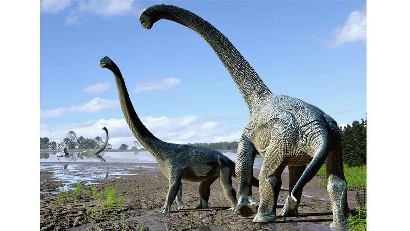
Fossil of young long-necked dinosaur found—and nicknamed Andrew
In what is now Montana, some 150 million years ago, a young dinosaur roamed through a land before (modern) time. Not yet five years old, the long-necked creature somehow ended up buried in a violent, muddy flood, forever freezing it in adolescence.
The fossil skull of the young diplodocus (CMC VP14128), nicknamed “Andrew” and held by palaeontologist D. Cary Woodruff. (John P. Wilson)
Now, researchers have freed this potentially record-setting dinosaur from its stony slumber. After uncovering the remains, the scientists published a study in Scientific Reports, in which they argue that the skull is the smallest yet found from a group of long-necked dinosaurs called diplodocids.
The little fellow even has a nickname: Andrew, after the steel baron and philanthropist Andrew Carnegie, who funded palaeontology research and has a diplodocid species named after him
With its skull just 10 inches across, researchers’ best guess is that Andrew was a juvenile Diplodocus—an especially rare find. While more than a hundred Diplodocus specimens have been discovered, their skulls are much rarer. Fewer than a dozen have been dug up to date. If the researchers’ reconstruction is correct, Andrew’s skull could be the smallest and least mature Diplodocus skull ever found, potentially providing insights into the dinosaur’s development.
“The smallest Diplodocus skull could tell us a lot about how Diplodocus grew up,” says palaeontologist D. Cary Woodruff, a PhD student at the University of Toronto and the study’s lead author.
‘Free rein at the salad bar’
Andrew hails from Montana’s Mother’s Day Quarry, a bone bed that contains at least sixteen juvenile dinosaurs, their bones are strewn about like a game of pick-up-sticks.
The remains are buried in pebble-flecked mud, suggesting that a flood may have overwhelmed a herd of young diplodocids. Due to the angles at which the bones were stuck in the muck, researchers think that other dinosaurs later trampled the bodies.
Andrew emerged from these rocks in 2010 during an excavation led by study coauthor and Cincinnati Museum Center palaeontologist Glenn Storrs. Storrs then reached out to Woodruff to give the fossil a closer look.
To Woodruff, the skull seemed to belong to a Diplodocus, though its features differed greatly from those of mature individuals. For one, Andrew had 13 teeth in its lower jaw, some of which had spoon-like edges to slice through rough vegetation. In contrast, only 11 peg-like teeth, good for nabbing softer vegetation, occupied the lower jaws of Diplodocus adults. Second, Andrew’s snout was narrow like a deer’s, whereas Diplodocus adults had broader snouts, more like a cow’s.
Woodruff thinks these differences tell the story of a shifting diet as the dinosaurs matured, echoing a 2010 study of a different Diplodocus juvenile skull.
Adult Diplodocus were lawnmowers, gobbling ferns and other soft plants in bulk. But young Diplodocus may have been more selective eaters, using their dental variation to nibble on the choicest parts of many different kinds of plants.
“Because they’ve got these different tooth types, it’s kind of like of a Swiss army knife in their mouth, right? They can pick and eat every plant they want to,” says Woodruff. “[They had] free rein at the salad bar.”
A puzzle with missing pieces
Kristi Curry Rogers, a palaeontologist at Macalester College in Minnesota, welcomes the new paper, but she doesn’t fully agree with its findings because of the fossil’s poor preservation. Andrew’s skull is missing parts of the cheek, palate, and lower jaw, plus the fossils are slightly squished. These hiccups make it hard to reconstruct the skull, let alone infer the dinosaur’s behaviour from it.
An illustration of the young diplodocus “Andrew” in its environment. (Andrey Atuchin) (Andrey Atuchin./Andrey Atuchin)
“The authors don’t address the deformation of the skull or the missing components of the face in any great detail, the inclusion of which could easily, and dramatically, change the interpretations,” she said in an email.
The uncertainty also muddies Andrew’s status as a member of the Diplodocus genus. When researchers tried to calculate Andrew’s place on the diplodocid family tree, its position depended on which of the dinosaur’s traits the researchers looked at.
“This is actually the part of the paper that I found the most interesting and important,” said palaeontologist Kimberley Chapelle, a PhD student at the University of the Witwatersrand in South Africa, in an email. The confusion may simply stem from growing pains; young and old Diplodocus could have looked very different, leading to challenges in categorization.
For now, Woodruff says that Diplodocus is his best guess for Andrew’s identity, but he says that it could also be an unknown species. To help settle the debate, Andrew’s skull is currently being 3-D scanned for future research.
“[At] the end of the day, that’s science: one object, two interpretations, multiple testable hypotheses,” said Woodruff in an email. “And if we’re later proven wrong about the identity, that’s fine. Andrew still contributes to our understanding … regardless of whatever the heck it is.”
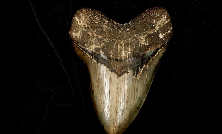
Unexpected: Scientists Find the Fossil of a 91-Million-Year-Old Shark in Kansas
A 91-million-year-old fossil shark newly named Cretodus houghtonorum discovered in Kansas joins a list of large dinosaur-era animals.
Preserved in sediments deposited in an ancient ocean called the Western Interior Seaway that covered the middle of North America during the Late Cretaceous period (144 million to 66 million years ago), Cretodus houghtonorum was an impressive shark estimated to be nearly 17 feet or slightly more than 5 meters long based on a new study appearing in the Journal of Vertebrate Paleontology.
The fossil shark was discovered and excavated in 2010 at a ranch near Tipton, Kansas, in Mitchell County by researchers Kenshu Shimada and Michael Everhart and two central Kansas residents, Fred Smith and Gail Pearson.
Shimada is a professor of paleobiology at DePaul University in Chicago. He and Everhart are both adjunct research associates at the Sternberg Museum of Natural History, Fort Hays State University in Hays, Kansas. The species name houghtonorum is in honour of Keith and Deborah Houghton, the landowners who donated the specimen to the museum for science.
Although a largely disarticulated and incomplete skeleton, it represents the best Cretodus specimen discovered in North America, according to Shimada. The discovery consists of 134 teeth, 61 vertebrae, 23 placoid scales and fragments of calcified cartilage, which when analyzed by scientists provided a vast amount of biological information about the extinct shark.
Besides its estimated large body size, anatomical data suggested that it was a rather sluggish shark, belonged to a shark group called Lamniformes that includes modern-day great white and sand tiger sharks as distant cousins, and had a rather distinct tooth pattern for a lamniform shark.
“Much of what we know about extinct sharks is based on isolated teeth, but an associated specimen representing a single shark individual like the one we describe provides a wealth of anatomical information that in turn offers better insights into its ecology,” said Shimada, the lead author on the study.
“As important ecological components in marine ecosystems, understanding about sharks in the past and present is critical to evaluate the roles they have played in their environments and biodiversity through time, and more importantly how they may affect the future marine ecosystem if they become extinct,” he said.
During the excavation, Shimada and Everhart believed they had a specimen of Cretodus crassidens, a species originally described from England and subsequently reported commonly from North America. However, not even a single tooth matched the tooth shape of the original Cretodus crassidens specimen or any other known species of Cretodus, Shimada said.
“That’s when we realized that almost all the teeth from North America previously reported as Cretodus crassidens belong to a different species new to science,” he noted.
The growth model of the shark calibrated from observed vertebral growth rings indicates that the shark could have theoretically reached up to about 22 feet (about 6.8 meters).
“What is more exciting is its inferred large size at birth, almost 4 feet or 1.2 meters in length, suggesting that the cannibalistic behaviour for nurturing embryos commonly observed within the uteri of modern female lamniform must have already evolved by the late Cretaceous period,” Shimada added.
Furthermore, the Cretodus houghtonorum fossil intriguingly co-occurred with isolated teeth of another shark, Squalicorax, as well as with fragments of two fin spines of a yet another shark, a hybodont shark.
“Circumstantially, we think the shark possibly fed on the much smaller hybodont and was in turn scavenged by Squalicorax after its death,” said Everhart.
Discoveries like this would not be possible without the cooperation and generosity of local landowners, and the local knowledge and enthusiasm of amateur fossil collectors, according to the authors.
“We believe that continued cooperation between palaeontologists and those who are most familiar with the land is essential to improving our understanding of the geologic history of Kansas and Earth as a whole,” said Everhart.
The new study, “A new large Late Cretaceous lamniform shark from North America with comments on the taxonomy, paleoecology, and evolution of the genus Cretodus,” will appear in the forthcoming issue of the Journal of Vertebrate Paleontology.
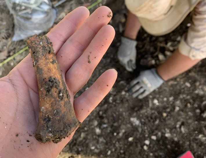
WTOP News reports that the possible site of a 300-year-old slave quarter has been found near an eighteenth-century brick manor once inhabited by Jesuit missionaries.
The announcement was made Tuesday by researchers from the Maryland Department of Transportation State Highway Administration and St. Mary’s College in Maryland.
According to MDOT SHA, most of the items were discovered close to the brick manor of 18th century once owned by Jesuit missionaries in Newtowne Neck State Park.
The quarters may date back to around 1700.
“The Jesuits were prolific in their record-keeping, but very little survived on the enslaved African Americans who worked the fields and served the Catholic Church,” said Julie Schablitsky, MDOT SHA’s chief archaeologist in a news release.
“If there was ever a place in Maryland that holds the story of diverse cultures converging to find religious freedom in an environment of conflict, sacrifice and survival, it is here.”
MDOT SHA said documents point to the sale of 272 slaves from Maryland in 1838 near the manor.
An artifact found near slave quarters in St. Mary’s County, Maryland.
Descendants of those slaves still live in Maryland.
The Rev. Dante Eubanks, a resident of Leonardtown, has traced his family to the St. Mary’s plantation.
“To be able to stand in the exact place where my ancestors lived and endured is a powerful experience,” Eubanks said. “We need to remember these stories, they are important to our history and healing.”
Maryland archaeologists are using metal detectors to pinpoint the locations of early cabins along Md. Route 243, places where the enslaved left evidence of their lives in broken clay tobacco pipes, ceramic cups and rusty nails.
“MDOT SHA’s participation in this archaeological dig is a unique way to experience history firsthand,” SHA Administrator Tim Smith said in a release.
“I’m proud of the work this team of archaeologists is doing to preserve the history of early Marylanders.”
MDOT SHA said the artefacts need to be analyzed to learn more.
The Kaibab Plateau located in central Northern Arizona showcases a mysterious majestic city epic in size and proportion. While this city is officially referred to as a series of natural “Grand Canyon Monuments”, they are in fact precisely arranged pyramids towers and temples aligned to both the star and nebula pattern of ORION “The Hunter” and Pleiades constellations.
This appears to be a great city of a “lost” continent hidden in plain sight. There is neither folklore nor definition of it, although, Egyptian and Asian artifacts have been found.
Some of which swiped under the guidance of the Smithsonian Institute. If giant Nephilim skeletons were recovered, only the inner circles of the secret societies would know. The city is veiled in secrecy using deceptive language and tactics as a device for keeping the general population from understanding what the “Monuments of the Grand Canyon” truly are.
The topographical map of the National Park shows the high elevations of the monuments named after Egyptian and Asian Gods, etc.
A water sculpted canyon. Now that’s a ‘wonder’
The Monuments embedded within this great chasm is now confirmed to be a set of pyramids and structures defining a city of such enormous expanse that it very well could have been the metropolis of a lost continent populated with an antediluvian civilization. The antediluvian period begins with the Creation according to Genesis and ends with the destruction of all life on the earth except those saved with Noah in the Ark, and possibly disguised by the knowledge of the secret societies.
This city is a remnant of an ancient continent. It remains a mystery, however, the notion that it may even be infamous and highly sought after the lost continent of Atlantis is certainly plausible, it most likely is a companion pyramid array not unlike what would be found at the 19th leyline node, Atlantis, or the first node where the great pyramid Khufu stands exactly in the centre of the earth plane.
The hypothetical “Lost land” known as Lemuria might be considered by some, however, the legend and theories regarding Lemuria are more rooted in fictional hearsay than would lend more research for revival here with the identifying location as a reasonable manner the city within the canyon. The opposite may be true as further research takes place in which more may be revealed.
West Java, Indonesia perhaps
In the case of the sunken continent of Atlantis, it has always been thought of as an entire parcel of land surrounded by the waters of the Atlantic Ocean. The world-renowned cosmic channel, Edgar Cayce, verifies this although sceptics and others have postulated otherwise.
One professor, the late professor Arysio Nunes dos Santos, suggests Atlantis is in the location of the newly discovered pyramids found on West Java, Indonesia. Other volumes of published materials produce mostly conjecture, however, without an honest look at real evidence. They are valiant efforts.
The likely truth is that a world flood did occur covering much of the topography of the land and seas in which when had mostly receded, Atlantis remained submerged and not sunken at all. Or, the waters that were added to the downpour of the waters from above creating the destructive force killing all life and devastating all constructs on the surface created a ‘sinkhole’ effect in which the mythical place we call Atlantis did actually sink.
There is a proof now that pyramids do exist in the Southwest United States. They do reside under an ancient seabed which establishes that they are all coordinated and line up precisely with the major stars and nebulae of the constellation Orion “The Hunter”. The same has been established with the great pyramids of Giza in Egypt. The difference is that all of the stars and nebulae of Orion match with the canyon Monuments with clarity.
The Grand Canyon with all its pristine beauty is neither naturally formed or organic in nature. This unique area at the Kaibab Plateau is indeed a widespread chasm that could not have possibly been carved out by a tumultuous river which is narrow by comparison. A simple observation of the angularity about the Monuments shows that they are devoid of sweeping curves on the stones. This logically demonstrates that water did not spend enough time sculpting smooth forms.
Is the historic record genuine?
If geologists, archaeologists, scientists of all areas agree that the mighty Colorado River in it’s strange but rather small in scale and configuration could form this canyon, then perhaps our geological historians are accurate. I agree that a river or series of them did cut vast areas of earth from the South to North rim and then on over to Nevada and down. I’ll buy the argument that simply because these are ancient structures built of hardened earth and that the soft was swept away over millions of years and so on has to be that simply because I’m showing proof these are aligned to stars.
I would have to also think that if we washed away all of the soft earth over the entire continent that we’d find the whole of our astrological system in the form of intelligently crafted pointed buildings. After all, what else other than a globe besieged by water could bury so many archaeological finds throughout the world? I do not believe that over time earthly renovations due to tropical storms, even hurricanes, tsunamis, and volcanic activity could have buried modern in ancient times cities.
There is evidence that mighty pointed formations are found in other canyons. And, they are also stepped and blocked. Blocks are angled at 90 degrees and these angles are seen in the Grand Canyon almost every yard of the way. This means that rivers did etch away doing its beautiful carving of the Great Deluge sediment from the original engineering constructs.
If this is absurd, then there’s room to suggest that there may have been an alien intentioned agenda at large. Perhaps there were massive ore harvesting projects aimed at stealing enormous caches of treasure, in particular, GOLD. A mining project as large as Massachusetts perhaps.
An Alien archaeological dig
If the historical record is wrong that a river the width of the Colorado River could have snaked its way completely and everywhere around these monumental features, then there must be an explanation as to how this massive ditch be created. The river could have been wider or several as opposed to the single one we know today, however, if there is an explanation, it would have to be alien inspired.
This great gorge may actually be an ancient geoforming project on the largest of scales known on planet Earth. The intent, obviously Alien, was to remove the softer ancient seabed sediment and earth that had engulfed the city. This occurred most likely during the flooding of the planet as told in Biblical terms regarding Noah and the story of the Ark.
This city then became an unearthed treasure trove find by off-world interests. Perhaps those who competed, or even battled against the Anunnaki of Nibiru (Planet X). Their goal perhaps for conquest over the megalithic cache of gold – primarily – that to a person living today be incomprehensibly vast. For you see, the Monuments of the Grand Canyon may have been completely covered – layered – in gold. The temples were filled as well as ordained with silver, gold and platinum. Aluminium was also a valuable metal. This city could very well have had the appearance of a scaled-up, way up, version of the most ornate crown of jewellery.
Why was this alien archaeological dig conducted?
A scene In the 2011 film Cowboys and Aliens in which an alien spaceship arrives in Arizona in 1873 to mine for gold, a unique technology was used. The scene to the right depicts unique liquid streaming of gold as it rises as if drippings along a string up from the depth of the canyon into the alien ship.
To plunder and harvest gold of coarse. A project of this size had to have been to liberate the treasure from a whole city the size of, well, the Grand Canyon. Alien ‘Pirates’! Once the city was revealed, some incredible technology had to have been implemented to strip the precious metals from the massive Monuments. Perhaps a complex smelting process was used. The gold then off-loaded to other locations on Earth or off-world. Hollywood, as always, gives us a “tell” in an alien-related film in which an unusual method is shown how an alien intelligence extracts gold from the earth. This is relevant for the reason it is taking place in Arizona, the location of the mining, or excavation, is in a canyon, and that it is being conducted by aliens. Furthermore, a war is taking place all because of gold.
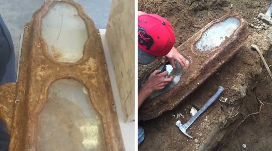
Century-Old Little Girl Found In Coffin Under San Francisco Home Identified
In the 1800s the mysterious girl, whose body was found under a house in San Francisco, her body entombed in a small lead and bronze coffin and her well-preserved hands clutching a single red rose, has been identified.
Garden of Innocence’s nonprofit project says the child — who not only astonished the work Crew who stumbled over the Casket but also city officials who thought the bodies in the 19th century Richmond District cemetery had all been moved — is Edith Howard Cook.
Edith was a month and a half short of her third birthday when she died Oct. 13, 1876, according to researchers working with the Southern California’s Garden of Innocence.
The cause of her death? Probably severe undernourishment caused by an infection, the researchers said.
The team had been working to identify the girl since her body was discovered during a home remodelling project near Lone Mountain.
Construction worker Kevin Boylan told KTVU: ‘All the hair was still there. The nails were there. There were flowers – roses, still on the child’s body. It was a sight to see.’
“It was a light at the end of the tunnel finding out who she is,” said Erica Hernandez, a project spokeswoman
The researchers, who included staff at UC Berkeley, UC Santa Cruz and UC Davis, located records from the old cemetery that was run by the Independent Order of Odd Fellows until about 1902, when the graves were relocated to Colma.
Although the paperwork was “unorganized,” Hernandez said, the team was able to cross-reference plot records with old newspaper obituaries and get an idea of who the young child might be.
Once it concluded that Edith was probably the girl, the team tracked down living relatives for a DNA sample to verify their finding. That confirmation came when a sample from Edith’s hair matched that of Peter Cook, a descendant of her brother, who lives in Marin County.
Edith Howard Cook was the second child and first daughter of Horatio Nelson and Edith Scooffy Cook. Peter Cook is descended from Edith’s older brother, Milton H. Cook.
Edith’s family was believed to be of decent means, having buried the child in a relatively expensive metal casket 37 inches in length, with two viewing windows on the lid.
Her skin and hair, as well as her burial flowers, were well preserved. She was one of about 30,000 people with graves at the old Odd Fellows Cemetery.
Why her remains weren’t transported to Colma around 1920, when the city wanted to make room for the living, remains a mystery.