Category Archives: U.S.A

A Lowa teenager searching for Arrowheads finds a 30,000-year-old mastodon jawbone instead

A Lowa teenager searching for Arrowheads finds a 30,000-year-old mastodon jawbone instead

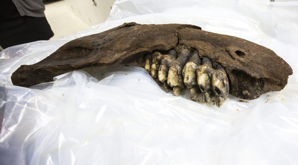
When hunting for arrowheads on an Iowa farm a teenager got a huge surprise. Instead of any arrowheads, the teen found a 30-inch jaw bone of a mastodon — a prehistoric hairy elephant, related to the mammoth. 

According to WHO-TV, a paleontology unit at the University of Iowa (UI) retrieved the jaw bone and other associated bones over the weekend.

“A few weeks ago we were informed that someone had discovered a fossil on the property in the middle of a small field,” Tiffany Adrain, head of the UI Paleontology Repository told the media.

A University of Iowa paleontology team was on a farm in southern Iowa to pick up the bone of a prehistoric mastodon.​

Facts About Mastodons

Appearance

Unlike modern elephants, mastodons had much smaller ears and foreheads and were covered in a thick layer of brown hair. Hairs on their coats could grow up to 35 inches (90 centimeters) and the males’ tusks grew to about 8 feet (2.5 meters). Females did not have tusks.

From foot to shoulder, mastodons were between 8 and 10 feet (2.5 and 3 m) tall. They weighed between 4 and 6 tons (3,500 and 5,400 kilograms), according to the Illinois State Museum.

That isn’t much different from their modern counterparts. Modern elephants weigh 3 to 7 tons (2,722 to 6,350 kg) and range from 5 to 14 feet (1.5 to 4.3 m) tall, according to The Defenders of Wildlife. 

Habitat

Though mastodons appeared primarily in North and Central America, they eventually spread all over the world, in every continent except for Antarctica and Australia. They typically inhabited spruce woodlands around valleys and swamps, according to Cochise College. 

Extinction

Mastodons went extinct around 10,000 years ago. There are many theories as to why. Most of these theories boil down to climate change and/or human hunting, according to Simon Fraser University.

Some scientists think that the Earth warmed up from the Ice Age too quickly for the mastodon to adapt or that humans hunted them to extinction.  

Others, like researchers Bruce Rothschild of the Northeastern Ohio Universities College of Medicine and Richard Laub of the Buffalo Museum of Science in New York, have a different theory.

They found that 52 percent of the 113 mastodons they studied had signs of tuberculosis. This led the researchers to think that a tuberculosis pandemic contributed to their extinction.

Though death by disease sounds like a cut-and-dry answer, “Extinction is usually not a one-phenomenon event,” Rothschild told Live Science.

It is likely that the disease didn’t kill off the animals directly, but made them weak. Coupled with the coming out of the Ice Age and fighting off humans, the species just couldn’t survive. 

Sculptures by artist Sergio de la Rosa show three elephant relatives, from left to right: the mastodon, the mammoth and the gomphothere.

Fossil discoveries 

The first mastodon fossils were found in 1705, according to the Oregon History Project, when a large tooth and bone fragments were found in the Hudson River Valley in New York.

Not long after, in 1807, Thomas Jefferson personally financed an expedition that was by led William Clark to excavate mastodon and mammoth fossils from the Big Bone Lick site in Kentucky.

There have been many mastodon fossil discoveries in the past few hundred years. Sometimes, they are found in unusual places. For example, on October 16, 1963, Marshal Erb was using a dragline to excavate a pond and found fossils that came to be known as the Perry Mastodon. In another instance in 2016, a sinkhole in Florida’s Aucilla River was declared an “archaeological gold mine” after an ancient human tool and mastodon bones are found inside.

“It was actually a high school student who had found the object, and the landowners contacted us and notified us [and] sent us photographs. Now we could tell right away it was a jaw bone of a mastodon,” she added.

The bone, which was then donated by the farmers to the UI Paleontology Repository, is believed to have belonged to a young mastodon that might have been 7-feet tall, the Iowa City Press-Citizen reported.

The couple who own the farm and donated the bones asked not to be named so that fossil hunters don’t trespass on their property. About 30 years ago, they had found other bones on their land that belonged to a woolly mammoth, WHOTV reported.

“I think people are finding stuff all the time,” Adrain told the Press-Citizen. “Maybe they are out canoeing or fishing on a bank. Farmers, in particular, on the land can spot things pretty easily.”
Archaeological Sites Investigated in Northern Alaska

Archaeological Sites Investigated in Northern Alaska

Archaeologist Jeff Rasic of the National Park Service has investigated archaeological sites at Howard’s Pass, a several miles–wide tundra plateau located in the mountains of northern Alaska’s Brooks Range.

A National Park Service climate-observing station in Howard Pass, a broad crossing of the Brooks Range between Alaska’s North Slope and the Noatak River drainage.

The sites date back some 11,000 years and include traces of houses, tent rings, food-storage pits, tool-making debris, and cairns that may have been used to help drive caribou into hunting traps. 

Jeff Rasic is an archaeologist for the National Park Service who has sifted through wet soil near Howard Pass. The pass, named for U.S. Navy explorer William Howard (who traversed it during an expedition on April 21, 1886), is more than 100 miles from the closest villages today, Ambler and Kobuk, both to the south.

Howard Pass was not so quiet over the past 11,000 years. In the area, archaeologists have found hundreds of house remains, tent rings, food-storage pits, scattered stone chips from tool makers and cairns that resembled humans to help drive caribou into traps.

“People took advantage of caribou, fish, muskox, berries, waterfowl — and in the earliest period, probably bison,” Rasic wrote about Howard Pass, a tundra bench several miles wide that caribou from the Western Arctic herd still click through during seasonal migrations.

This food-rich area has another side to its character. Howard Pass’s Inupiaq name is Akutuq, a word for a treat made of whipped animal fat, sugar, and berries. Natives gave the pass that name because the wind-tortured snow patterns there reminded them of akutuq.

National Park Service scientists in 2011 installed a rugged weather station at Howard Pass as one of 50 similar climate stations in hard-to-reach parklands across Alaska. The stations are battery and solar-powered and send their data in blips to orbiting satellites.

That information has included — on Feb. 21, 2013 — a wind-chill temperature of minus 96.9 degrees Fahrenheit. The air temperature that day was minus 45.5 degrees F. The wind blew at a sustained 54 miles per hour.

“This was not an isolated event,” Pam Sousanes of the National Park Service said of the Howard Pass windchill. “Similar conditions have been recorded in 2014, 2015, 2016 and 2017.”

The average wind chill for Feb. 12-16, 2014, was minus 84.5 degrees F when the highest wind gust through the pass was 103 miles per hour. Wind chills of minus 70 or lower have been recorded each year.

This low spot in the western Brooks Range becomes a wind tunnel when there a great atmospheric-pressure difference that exists between Alaska’s North Slope and the rest of the state. Cold air from the north rips southward though the pass.

“The wind chill can be so severe as to freeze to death caribou caught there by a winter storm,” wrote Ernest Burch in the book “Alliance and Conflict: The World System of the Inupiaq Eskimos.” “After every bad blow, the Eskimos used to go into the pass to look for well-preserved caribou carcasses.”

Sousanes and her colleague Ken Hill have replaced the wind monitor on the Howard Pass station every year; the steel mast that holds it up is pocked by rocks and ice.

Minus 100 degrees does not seem to mesh with human occupation; nor does a place with no firewood.

However, not only is the pass loaded with archaeological sites, a few of them are winter dwellings, Rasic said, with half the living area underground and featuring cold-trap tunnels at the entrances.

Why might people have chosen a spot with such inhumane conditions?

“It’s a reliable place to harvest caribou, and there are lakes with fish,” Rasic said. “If you are someone trying to escape clouds of mosquitoes, winds aren’t necessarily bad. And maybe a windswept place is good for winter travel — hard and crusty, good to get around on.”

Kansas Archaeologist Rediscovers Lost Native American City

Kansas Archaeologist Rediscovers Lost Native American City

A conqueror named Juan de Oñate led an expedition of 200 soldiers in 1601 into uncharted territories of what is today the state of Kansas.

Along with the soldiers and canons, the group was accompanied by a number of priests as well as adventurers who were attracted by the expedition’s final goal ― the legendary city of Quivira, whose streets were allegedly paved with gold.

Before Oñate chose to venture into the Great Plains, two other conquistadors ― Antonio Gutiérrez de Humana and Francisco Leyva de Bonilla ― already lost their lives there in 1594, while embarking on a similar quest.

Juan de Oñate, first Governor of New Spain.

But Oñate’s thirst for fame and riches, as well as an appetite for terror, led him and his posse deep into the unknown where he indeed discovered a large settlement, but it wasn’t exactly what he expected.

More than 400 years later, archaeologists from the Wichita State University flocked around a site which they believe was the place where Oñate found his Quivira, or Etzanoa, as it was known to the Native Americans.

Oñate’s 1605 “signature graffiti” on Inscription Rock, in El Morro National Monument.

Located in southern Kansas, at the confluence of the Walnut and the Arkansas rivers, it has been known for decades as a place of historical findings. Since 1959, both archaeologists and locals have discovered various artifacts belonging to the Wichita people.

Literally tons of objects belonging to an ancient civilization were collected after a road construction in 1994. Many of the objects are kept in private property, as it became common to find shards of pottery or pieces of arrowheads. However, never before was the connection made between these traces of settlement with the almost mythical city of Etzanoa ― discovered by Oñate’s expedition in 1601.

Trade beads found at a Wichita village site, c. 1740, collection of the Oklahoma History Center.
Protohistoric Wichita points found at Etzanoa.

The research was conducted under the supervision of Donald Blakeslee, a veteran archaeologist who became intrigued with finding the lost city in 2013, after new translations of various accounts of Spanish colonialists serving under Oñate during the Etzanoa expedition were made by scholars from UC Berkeley.

Together with the National Park Service, Blakeslee scanned the area with a magnetometer, enabling him to determine the variations in the earth’s magnetic field and locate remains of houses, cellars, and fireplaces belonging to a once vibrant settlement. Not far from the settlement’s location, in what is today a suburb of Arkansas City, traces of battle were also found, including three Spanish cannonballs, a horseshoe, and a number of other objects.

Protohistoric Wichita stone knives were recovered from the site by the Kansas State Historical Society.

Let’s head back to the year 1601 and the fate of Juan de Oñate’s expedition, to further unravel the story which led to this amazing discovery. After his vanguard came with reports that a large settlement lay ahead of them, the conquistador must have rubbed his hands in delight ― it was the chance to amass gold, and to convert the natives into Christianity, gaining favor from the Spanish Crown in return.

According to his scouts’ reports, the city seemed as though it stretched for miles. Large beehive-shaped houses with thatched roofs and fields of corn, squash, and beans overtook the horizon. Their estimate was that there must have been more than 20,000 people living there.

A sketch of a Wichita Indian village in the 19th century. The beehive-shaped grass-thatched houses surrounded by cornfields are characteristic and appear similar to those described by Coronado in 1541.
Esadowa (or Isadowa) was chief of the Wichita village adjacent to the Comanche camp attacked by Van Dorn in 1858. In 1861, Esadowa led his people north to Kansas, then in 1865 brought them back to the Indian Territory.

After they were approached by a friendly delegation bringing offerings, the Spanish took the welcoming committee as hostages, as they needed leverage while possibly facing an entire city in battle. As a response, Wichita warriors, who were calling for a fight with the invaders, put on their battle paint. Spanish soldiers named them Rayados ― due to tattoos and paint they wore on their faces and bodies.

Even though at one moment it looked as though they were going to face an army eager to fight, only a handful of people were found in the city as the conquistadors marched into it. The inhabitants of Etzanoa, perhaps familiar with the stories of vicious invaders and their firepower, decided it was safer to just evacuate the entire city for a while than to battle the treacherous Spaniards.

So when the conquistadors entered the city, it was already empty. They wandered the city for several days in their search for gold, counting more than 2,000 houses, all of which were big enough for 10 people.

Adam Ziegler holds an iron ball that he found with a metal detector. The ball, which was part of a cartridge load for a cannon, was the first piece of evidence that suggested the archaeologist had located the battlefield where the Spanish fought the Native Americans.

Once they decided to leave, however, they were met with a horde of 1,500 warriors belonging to the Escanxaques tribe, which rivaled the Wichita. Apparently, they were on a warpath, but instead of fighting their historical enemies, they ended up battling a small detachment of Spaniards who attempted to break through using cannons and muskets. By sheer luck alone, the conquistadors managed to withdraw from the battlefield, suffering heavy casualties.

Afterward, the accounts of their mishaps have often been discarded as exaggerated ramblings of adventurers who sought glory or support from the Spanish Crown. Modern historians dismissed the notion of a settlement of such scale, in part because of yet another expedition, this time under French leadership, that ventured into the same area around 100 years later, only to find what looked to them like untouched nature.

It is most likely that the settlement was abandoned and left to waste due to some sort of disease epidemic, which was the most common reason for the extinction of many other Native American cultures. Thanks to Blakeslee and his team, a real breakthrough is happening, as Etzanoa is estimated to be the second-largest ancient settlement in the United States, the first one being Cahokia in Illinois.

Researchers conducting a surface survey mark the locations of stone flakes, points, and tools with brightly colored flags.

The discovery is also reshaping the way that the history of Great Plains tribes is perceived. It was mostly believed that the tribes inhabiting North America lived in rural settlements or as nomads, as opposed to the vast cities of the Mayans and Incas in the south. However, the unearthing of Etzanoa goes to show that large urban areas existed and thrived as trade centers of civilizations long gone.

According to Jay Warren, an Arkansas City council member, plans are already put in motion to turn the site into a tourist attraction.

“We’re not talking about putting together a one-day wonder. We’re looking at creating something that could be great for the region, and for 50 years and more down the road. We’re talking with (Unified School District) 470 about how it could enhance education. And we think the site could also be a hands-on field training facility for archaeologists from all over the world.”

A gigantic natural quartz crystal cluster was mined from the Colemans quartz mine near Jessieville

A gigantic natural quartz crystal cluster was mined from the Colemans quartz mine near Jessieville

On a Reddit site on Sunday, almost two years after it was found in the Arkansas mine, a picture of 3.5 million dollars chunk of quartz was taken.

Ron Coleman left, and his son Josh Coleman, right, found an 8-foot, 2,000-pound crystal while digging at a mine in Jessieville

This mine was and is the most productive quartz mine in Arkansas. It has been producing quartz crystals in large quantities since 1943. When it is operating it has produced about 60,000 pounds of quartz crystals during a good month.

The image shows a man posing with an 8-foot block of crystals found in the Ron Coleman Mine in Jessieville, about 30 minutes north of Hot Springs.

The man pictured was not a visitor to the mine, which is open year-around for public digging, but an employee who worked on a team to extract the mineral over a four-day excavation said Joel Ledbetter, an online marketer for Ron Coleman Mining.

A $3.5 million chunk of quartz found in Arkansas was featured on the Reddit home page Sunday.

A $3.5 million chunk of quartz found in Arkansas was featured on the Reddit home page Sunday.

“We had a good guess it was there because there’s a 170-mile quartz vein that runs through Arkansas, so we started digging,” Ledbetter said.

Crews blasted the area until they found the vein and then used hand tools to dig out the 2,000-pound chunk that machines lifted out of the mine.

The crystal cluster is one of the most impressive pieces to come out of the quarry since people started digging before World War II — in part to retrieve crystals used in early radios, Ledbetter said.

The 8-foot, 2,000-pound crystal cluster found at the Ron Coleman mine is being kept at the quarry until a buyer is found.

The 8-foot, 2,000-pound crystal cluster found at the Ron Coleman mine is being kept at the quarry until a buyer is found.

The latest find is second in size to only a 9-foot, a 3,000-pound circular formation that was found in the mine just a year or two before.

While the larger piece is on display at various trade shows in Arizona, the other remains in Jessieville until it can be sold.

Ledbetter said several people have inquired about the $3.5 million crystal cluster, but the company has not yet found the right buyer.

That may change as the photo gains popularity as it spreads among various social media platforms.

“Someone really big into crystals probably shared it, and other people who hadn’t seen it saw it and got excited about it,” Ledbetter said. “Anytime people talk about mine, it’s good publicity. People get into crystals but don’t necessarily get to see all that comes out of here.”

The life and death of one of America’s most mysterious trees

The life and death of one of America’s most mysterious trees

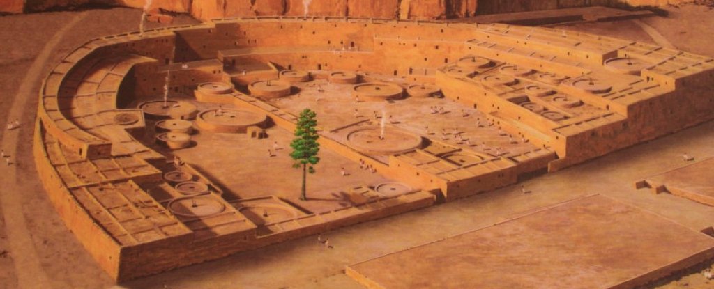
In the Centre of Chaco Canyon in New Mexico, a towering ponderous tree, known as the “Plaza Tree,” was once built to be a symbol of life and a center of the world for an ancient pueblo town. But new research suggests it may have been just a giant log no one bothered to move for 800 years, and maybe didn’t hold significant meaning. 

The “Plaza Tree of Pueblo Bonito” was thought to be a living “world tree” for ancestral Puebloans. But researchers have found that it grew 50 miles away and was dead when it was hauled there.

“I believe the tree was dead when it had been taken into the canyon,” said Chris Guiterman, a research assistant scientist studying ancient trees at the Tucson University of Arizona.

For over a hundred years, people assumed the tree had meaning; it was regarded as a “tree of life”, according to one researcher, or a “world tree.” The solitary tree was once thought to represent the living “center of the world” for the people of Pueblo Bonito, the largest of Chaco Canyon’s “great houses,” which was occupied between A.D. 850 and 1150.

Some speculations placed the tree at the center of a religious cult, and an illustration of a growing “Plaza Tree of Pueblo Bonito” appears in a brochure from the National Park Service.

Guiterman and his colleagues discovered that the Plaza Tree probably didn’t grow at Chaco Canyon, but more than 50 miles (80 kilometers) away. They also found no evidence that the tree had a religious role — it might have been a pole, or a beam for a house, or firewood.

“I actually have no idea whether it did, does, or ever had religious significance,” Guiterman told Live Science in an email. “I don’t know what it was used for, or why it was located in the plaza where it was found.”

Pueblo Bonito is the largest of the adobe “great houses” in Chaco Canyon. It was occupied between 850 and 1158 AD and is considered the center of the Chaco world.

“Tree of life”

The researchers studied three aspects of the Plaza Tree: documents about the discovery of its 20 foot (6 meters) long trunk in Pueblo Bonito in 1924; the levels of isotopes of the chemical element strontium within samples of its wood, which can identify where it came from; and the width of its tree rings, which can show seasonal growth.

Ideally, the tree rings would have been compared to rings from trees of the same age, wrote the researchers in the study, published online March 13 in the journal American Antiquity — but that wasn’t possible, so they used the rings in modern trees to determine distinctive growth patterns based on the climate of particular areas.

The researchers found that the tree ring width and the strontium isotopes of the Plaza Tree didn’t match those of ponderosa pine trees that grew around Chaco Canyon — instead, they closely matched trees that grew in the Chuska Mountains, about 50 miles (80 kilometers) west.

The Chuska Mountains region “also happens to be the primary source for architectural wood used to construct Pueblo Bonito and other Chaco great houses,” Guiterman said.

The researchers determined that archaeologist Neil Judd of the Smithsonian Institution, who excavated Pueblo Bonito in the 1920s, failed to find any sign of deep roots from the tree in the plaza where it was found, and initially dismissed the idea that it had been growing there.

But Judd’s dismissal seems to have been overlooked in his following interpretation in the 1950s when he described the Plaza Tree as the last living remnant of an ancient forest that once existed at Chaco Canyon.

The researchers studied the width of the ancient tree rings and their levels of isotopes of strontium in the wood of the Plaza Tree to determine how old it was and where it came from.

Ancient pueblos

Recent research has shown that logs were often hauled for dozens of miles to build the pueblos at Chaco Canyon, Guiterman said: “hundreds of thousands of timbers were used in the construction of [the] great house structures.”

The Plaza Tree is one of only two logs found in an ancestral Puebloan structure that were not parts of buildings. The other is a 32 foot (10 m) long log of white fir at the Kiet Siel cliff dwelling in Arizona, discovered in the 1890s. That unexpected find may have prompted Judd’s more elaborate interpretation of the Plaza Tree, Guiterman said.

“It was a puzzling discovery — one of a kind, really,” he said. “It served as evidence for an early idea that Chaco Canyon was heavily forested before the great houses were constructed, and that the hundreds of thousands of beams came from that local forest.”

The researchers looked again at several theories surrounding the Plaza Tree, including that it served as a gnomon — the upright that casts a shadow — of an ancient sundial. “Although we cannot confirm that [the Plaza Tree] was actually long enough to be a gnomon, it is certainly possible,” they wrote.

The tree may also have served as an upright pole in ceremonies and festivals, such as the pole-climbing that features in some Native American festivals and which may have originated in ancient Mesoamerica, the researchers wrote. The branches and logs of pine trees are used in some Puebloan ceremonies today. 

But the Plaza Tree also could have had a much more mundane use. “It might have been a log staged for construction of a new room, or to replace a damaged beam in an existing room,” they wrote. “It could have been a bench, or intended for fuelwood [firewood].”

The Mystery behind the 18 Giant Skeletons found in the USA

The Mystery behind the 18 Giant Skeletons found in the USA

18 Strange Skeletons Found in Wisconsin Nine-foot Skeletons with Huge Heads and Strange Facial Features Shocked Scientists When They Were Uncovered 107 Year Ago Scientists are remaining stubbornly silent about a lost race of giants found in burial mounds near Lake Delavan, Wisconsin, in May 1912.

The dig site at Lake Delavan was overseen by Beloit College and it included more than 200 effigy mounds that proved to be classic examples of 8th century Woodland Culture. But the enormous size of the skeletons and elongated skulls found in May 1912 did not fit very neatly into anyone’s concept of a textbook standard.

They were enormous. These were not average human beings.

Strange Skulls

First reported in the 4 May 1912 issue of the New York Times, the 18 skeletons found by the Peterson brothers on Lake Lawn Farm in southwest Wisconsin exhibited several strange and freakish features.

Their heights ranged between seven and nine feet and their skulls “presumably those of men, are much larger than the heads of any race which inhabit America to-day.”

Above the eye sockets, “the head slopes straight back and the nasal bones protrude far above the cheekbones. The jawbones are long and pointed, bearing a minute resemblance to the head of the monkey. The teeth in the front of the jaw are regular molars.”

Their heights ranged between 7.6ft and 10 feet and their skulls “presumably those of men, are much larger than the heads of any race which inhabit America to-day.” They tend to have a double row of teeth, 6 fingers, 6 toes and like humans came in different races. The teeth in the front of the jaw are regular molars. Heads usually found are elongated believed due to longer than normal life span.

The mystery of The Wisconsin Giants

Was this some sort of prank, a hoax played by local farm boys or a demented taxidermist for fun and the attention of the press? The answer is no.

The Lake Delavan find of May 1912 was only one of the dozens and dozens of similar finds that were reported in local newspapers from 1851 forward to the present day. It was not even the first set of giant skeletons found in Wisconsin.

On 10 August 1891, the New York Times reported that scientists from the Smithsonian Institution had discovered several large “pyramidal monuments” on Lake Mills, near Madison, Wisconsin. “Madison was in ancient days the center of a teeming population numbering not less than 200,000,” the Times said. The excavators found an elaborate system of defensive works which they named Fort Aztalan.

“The celebrated mounds of Ohio and Indiana can bear no comparison, either in size, design or the skill displayed in their construction with these gigantic and mysterious monuments of the earth — erected we know not by whom, and for what purpose we can only conjecture,” said the Times.

On 20 December 1897, the Times followed up with a report on three large burial mounds that had been discovered in Maple Creek, Wisconsin. One had recently been opened.

“In it was found the skeleton of a man of gigantic size. The bones measured from head to foot over nine feet and were in a fair state of preservation. The skull was as large as a half bushel measure. Some finely tempered rods of copper and other relics were lying near the bones.”

Giant skulls and skeletons of a race of “Goliaths” have been found on a very regular basis throughout the Midwestern states for more than 100 years. Giants have been found in Minnesota, Iowa, Illinois, Ohio, Kentucky, and New York, and their burial sites are similar to the well-known mounds of the Mound Builder people.

The spectrum of Mound builder history spans a period of more than 5,000 years (from 3400 BCE to the 16th CE), a period greater than the history of Ancient Egypt and all of its dynasties.

There is a “prevailing scholarly consensus” that we have an adequate historical understanding of the peoples who lived in North America during this period. However, the long record of anomalous finds like those at Lake Delavan suggests otherwise.

The Great Smithsonian Cover-Up

Has there been a giant cover-up? Why aren’t there public displays of gigantic Native American skeletons at natural history museums?

The skeletons of some Mound Builders are certainly on display. There is a wonderful exhibit, for example, at the Aztalan State Park where one may see the skeleton of a “Princess of Aztalan” in the museum.

But the skeletons placed on display are normal-sized, and according to some sources, the skeletons of giants have been covered up. Specifically, the Smithsonian Institution has been accused of making a deliberate effort to hide the “telling of the bones” and to keep the giant skeletons locked away.

In the words of Vine Deloria, a Native American author, and professor of law:

“Modern day archaeology and anthropology have nearly sealed the door on our imaginations, broadly interpreting the North American past as devoid of anything unusual in the way of great cultures characterized by a people of unusual demeanor. The great interloper of ancient burial grounds, the nineteenth century Smithsonian Institution, created a one-way portal, through which uncounted bones have been spirited. This door and the contents of its vault are virtually sealed off to anyone, but government officials. Among these bones may lay answers not even sought by these officials concerning the deep past.”

Maize, not metal, the key to native settlements’ history in New York

Maize, not metal, the key to native settlements’ history in New York

The Recent Cornell University research offers a more detailed historical timeline for the occupation of Native American sites in upstate New York, based on radiocarbon dating of organic materials and statistical modeling.

Reports from the study of a dozen sites in Mohawk Valley were recently published by Sturt Manning in the online journal PLoS ONE, the professor of classical archeology; and John Hart, curator in the research and collections division of the New York State Museum in Albany.

The findings, Manning said, are helping to refine our understanding of the social, political, and economic history of the Mohawk Valley region at the time of early European intervention.

The Iroquoian Study

The work is part of the Dating Iroquoia Project, involving researchers from Cornell, the University of Georgia, and the New York State Museum, and supported by the National Science Foundation.

The new paper continues and expands upon research on four Iroquoian ( Wendat) sites in southern Ontario, published by the project team in 2018. Using similar radiocarbon dating and statistical analysis methods, the 2018 findings also impacted the timelines of Iroquoian history and European contact.

A map showing the Mohawk Valley region in northeast North America and all the Iroquoian sites analyzed in this study.

“The Mohawk case was chosen because it is an iconic series of indigenous sites and was subject to one of the first big dating efforts in the 1990s,” said Manning. “We have now examined a southern Iroquois ( Haudenosaunee) case as well as a northern Iroquois (Wendat) case, and we again find that the previous dating scheme is flawed and needs revision.”

The Mohawk and Hudson river valleys were key inland routes for Europeans entering the region from the coast in the 16th and early 17th centuries. Colonization of the new world enriched Europe (Manning has described this period as “the beginning of the globalized world”) but brought disease and genocide to indigenous peoples, and their history during this time is often viewed in terms of trade and migration.

Iroquoian Trade Goods

The standard timeline created for historical narratives of indigenous settlement, Manning noted, has largely been based on the presence or absence of types of European trade goods – e.g., metal items or glass beads. Belying this Eurocentric colonial lens, trade practices differed from one native community to another, and not all of them accepted contact with, or goods from, European settlers.

Iroquois engaging in trade with Europeans.

To clarify the origins of metal goods found in the upstate New York settlements, the team used portable X-ray fluorescence (pXRF) analysis to determine whether copper artifacts were of native or European origin. They then also re-assessed the dates of the sites using radiocarbon dating coupled with Bayesian statistical analysis.

Bayesian analysis, Manning explained, is “a statistical method that integrates prior knowledge in order to better define the probability parameters around a question or unknown. In this case, archaeological and ethnohistorical information was combined with data from a large set of radiocarbon dates in order to estimate occupation dates for a set of Mohawk villages across the 13th to early 17th centuries.”

The focus was on the period from the late 15th to the early 17th century, he said, or “the long 16th century of change in the northeast”. The results “add to a growing appreciation of the interregional variations in the circulation and adoption patterns of European goods in northeastern North America in the 16th to earlier 17th centuries,” Manning said.

Iroquoian History Reevaluated

In previous indigenous site studies, where artifacts indicated trade interactions, researchers might assume “that trade goods were equally available, and wanted, all over the region,” and that different indigenous groups shared common trade practices, he said. Direct radiocarbon dating of organic matter, such as maize kernels, tests those assumptions and removes the colonial lens, allowing an independent timeframe for historical narratives, Manning said.

At several major Iroquois sites lacking close European connections, independent radiocarbon studies indicate substantially different date ranges from the previous estimates based on trade goods.

“The re-dating of a number of Iroquoian sites also raises questions about the social, political and economic history of indigenous communities from the 14th to the 17th centuries,” Manning said. “For example … a shift to larger and fortified communities, and evidence of increased conflict,” was previously thought to have occurred around the mid-15th century.

The study of the Iroquoian sites also raises questions about the dating of conflicts.

But the radiocarbon findings from some larger sites in Ontario and their cultivated maize fields ¬- 2,000 acres or more in some instances — date the sites from the mid-16th to the start of the 17th century, he said. “However, as this New York state study shows, other areas had their own and differing trajectories. Thus with direct dating we start to see real, lived, histories of communities, and not some imposed generic assessment,” Manning said.

“The emerging new and independent timeframe for northeast North America will now form the basis of a wider indigenous history,” Manning stated, “free from a Eurocentric bias, with several past assumptions open for an overdue rethink.” Cornell University has dedicated television and audio studios available for media interviews supporting full HD, ISDN, and web-based platforms.

200 million-year-old shoe print found on a lump of coal

200 million-year-old shoe print found on a lump of coal

In the past, there have been countless mysterious discoveries that point to the fact that modern humans lived on Earth much earlier than scholars say. Such unexplained observations referred to by many authors as ‘ ooparts — or out of place artifacts’, these enigmatic findings push the boundaries set forth by mainstream scholars, challenging everything we know about modern humans and life on Earth.

A hundred years ago, a Nevada Mining Company employee named Albert E. Knapp made the enigmatic — and somewhat controversial — discovery. To be precise in January 1917.  In an article at creationism.org, we find a letter written by Mr. Knapp—the discoverer—dating back to January 15, 1917.

“I was intrigued by the fossil, which laid on the stone side among some loose rocks, as I descended the hill my attention was attracted by the fossil. I took it and placed it in my pocket for further analysis and it came to the conclusion that it is a layer from the heel of a shoe which had been pulled from the balance of the heel by suction; the rock was in a plastic state at that time. It was found in LIMESTONE OF THE TRIASSIC PERIOD, a belt of which runs through that section of the hills.”

There are however several websites that wrongly concluded that the ‘ 200 million-year-old fossilized shoeprint ‘ was found in Triassic rock near Fisher Canyon, Pershing County, Nevada by John Reid in 1922.

The enigmatic object caught the attention of several researchers who were looking forward to analyzing it. The object also caught the eyes of the media as we find two reports about the discovery in a March 19, 1922 story in the New York Times: “It would fit nicely a boy of ten or twelve years. The edges are as smooth as if freshly cut. The surprising part of it is what seems to be a double line of stitches, one near the outside edge of the sole and the other about a third of an inch inside the first. The ‘leather’ is thicker inside the inner welting and appears to be slightly bevelled, so that at the margin, half an inch wide, which runs outside, the sole is something like an eighth of an inch thick.

The symmetry is maintained perfectly throughout. The perfect lines pursued by the welting, and the appearance of hundreds of minute holes through which the sole was sewed to the shoe are the things which make the object such an extraordinary freak in the eyes of the scientists who examined it.

And an October 8, 1922 article by W. H. Ballou in the American Weekly section of the New York Sunday American titled: “Mystery of the Petrified Shoe Sole”:

“…Some time ago, while he was prospecting for fossils in Nevada, John T. Reid, a distinguished mining engineer, and geologist stopped suddenly and looked down in utter bewilderment and amazement at a rock near his feet. For there, a part of the rock itself was what seemed to be a human footprint! Closer inspection showed that it was not a mark of a naked foot, but was, apparently, a shoe sole which had been turned into stone.

The forepart was missing. But there was the outline of at least two-thirds of it, and around this outline ran a well-defined sewn thread which had, it appeared, attached the welt to the sole. Further on was another line of sewing, and in the center, where the foot would have rested had the object really been a shoe sole, there was an indentation, exactly such as would have been made by the bone of the heel rubbing upon and wearing down the material of which the sole had been made. Thus was found a fossil which is the foremost mystery of science today. For the rock in which it was found is at least 5 million years old…”

However, as noted by paleo.cc, the article that appeared in New York Sunday American mistakenly credits Reid instead of Knapp as the person who discovered it, but it offers misleading details about the age to the artifact.

Several authors concluded upon closer inspection that the rock shows “a layer from the heel of a shoe which had been pulled up from the balance of the heel by suction, the rock being in a plastic state at the time.”

Furthermore, it is noted that the alleged shoe print was in a marvelous state of preservation—as the edges of the heel were smooth and rounded off as if cut and its right side appeared more worn than the left—an indicative sign that it had been worn on the right foot.

However, many authors and websites—who disagree with mainstream history mostly—argue that what Knapp found really amazing was that the rock in which the heel mark was made, was a Triassic rock—believed to be at least 220 million years old—which runs in a belt through the canyon hills where the enigmatic shoeprint was discovered.

But author Glen J. Kuban notes that there are several issues with the shoeprint interpretation.

The Kuban notes that from the only photographs from the artifact, we can deduce that it seems to be a broken ironstone concretion, one that may have suffered from erosion. Interestingly, such concretions tend to display ovoid shapes and concentric banding like the one discovered in the alleged 200 million-year-old shoe print.

As noted by essayfarm.com, Concretions are hard to compact accumulations of mineral matter and are found inside sedimentary rocks. Often concretions are mistaken for bones, fossils, meteorites and other odd objects. They can be so small that it requires a magnifying glass to be visible or as large as 10 feet in diameter and weigh hundreds of pounds.  Concretions can also have somewhat of regular shapes such as boxes, blocks, flat disks, pipes, cannonballs and have even been known to resemble parts of a human body such as a foot or ribs.

As noted in the book God-Or Gorilla by McCann, Alfred Watterson, 1879-1931, the Rockefeller Institute conducted microscopic photography of the print, which showed that the object in question contained the presence of two rows of stitching, about 1/3″ apart, with the appearance of hundreds of minute holes through which the soul was sewed to the shoe. Regrettably, no microscopy images were published to back the claims.

“The edges are rounded off smoothly as if it were freshly cut leather from an expert cobbler. The stone to which it is attached is about the size of a brick. The heel and part of the sole appear, the toe-end being missing.”

Creationsim.org states that the above-mentioned microphotographs showed very clearly that it bore a minute resemblance to a well-made piece of leather, stitched by hand, and at one time worn by a human foot.

The photographs showed the stitches very plainly; at one place it was double-stitched, and the twist of the thread could be clearly seen. The thread is smaller than any used by shoemakers of today. Minute crystals of sulphide of mercury are to be noticed throughout the spaces of this fossil shoe-sole, these minerals having been deposited in the long ago by waters which carried them in solution.

Regrettably, the present location of the artifact is unknown, so further studies cannot be conducted.