High-Tech Equipment Leads to Discovery of Lost City in Cambodian Jungle
Each year, hundreds of thousands of people from all over the world flock to Cambodia to visit the famous Angkor Wat temple. But it appears that there may soon be new sites to visit, as research has revealed details of medieval cities under the jungle.
Wissenschaftler used laser technology to shed new light on the civilization behind the biggest religious complex in the world. During the time of investigations for several years, new findings reveal a much larger scale than was previously thought of in the urban expanse and temple complexes of the Khmer Empire.
Using high-tech lasers to scan the Cambodian jungle, Damian Evans and colleagues say they found traces of extensive networks surrounding the monumental stone temple complex at Angkor Wat. Evans said their findings could further our understanding of Khmer culture and throw into question traditional assumptions about the 15th-century decline of the empire.

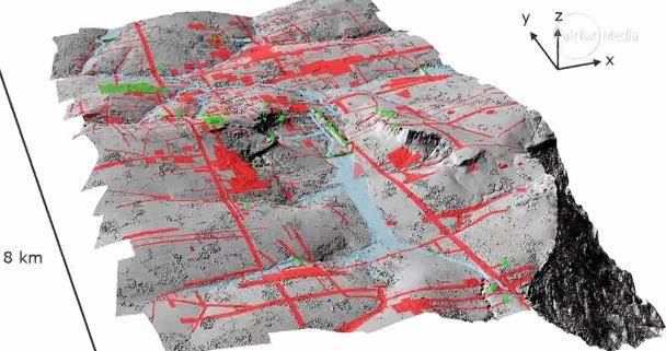
Evans said a laser technology known as lidar was used to create precise maps of ancient networks that left only vague traces – invisible to the naked eye – in the landscape surrounding the temples.
‘You could be standing in the middle of the forest looking at what appear to be some random lumps and bumps,’ Evans said.
But they might actually be evidence of old excavated ponds or built-up roadways,’ he explained. ‘All of these things left traces on the surface of the landscape that wouldn’t make sense to you without a more detailed picture. To obtain such details, Evans said his colleagues spent 90 hours in a helicopter directing laser scans into the jungle surrounding Angkor Wat.
He said that the resulting images are so intricate ‘you can see objects lying next to a tiny anthill.’ The research was published Monday in the Journal of Archaeological Science. It was the result of a joint project including the French Institute of Asian Studies in Paris, the Cambodian national authority responsible for protecting Angkor Wat and the ministry of culture and fine arts.


For years, experts have assumed that the ancient Khmer civilization collapsed in the 15th century when invading Thai armies sacked Angkor Wat, forcing populations to relocate to southern Cambodia. But Evans said their laser maps showed no evidence of relocated, dense cities in the south and that it wasn’t clear there was any such mass migration.
Chanratana Chen, a Cambodian academic at the University of Sorbonne in Paris, said the new findings had changed his own perception of the Angkor Wat temple complex, which the Cambodian people commonly refer to as ‘the small city.’ Chen was not involved in the new research.
‘The new results (show) us that Cambodia was a much more advanced civilization than we thought, especially about the management plan of the city and irrigation system to improve agriculture in the area,’ Chen wrote in an email.
Among the most noteworthy discoveries, Evans and colleagues had found were proof of medieval sandstone quarries and traces of a royal road between various temple complexes, he said.
Evans doubted tourists would soon be flocking to see the unremarkable ‘mounds in the ground’ that the lasers had decoded at Angkor Wat. But said he and colleagues have now pinpointed sites that might be fruitful for further excavation.
He said it was likely there could be similar such discoveries elsewhere in Southeast Asia, possibly in Burma and even the Americas, where archeologists might unearth more secrets about the remains left behind by the 6th-century Mayan Empire.
Angkor Wat, a UNESCO World Heritage site, is considered one of the ancient wonders of the world. It was constructed from the early to mid-1100s by King Suryavarman II at the height of the Khmer Empire’s political and military power and was among the largest pre-industrial cities in the world.
The new findings build on scans that confirmed the existence of Mahendraparvata, an ancient temple city near Angkor Wat. However, until now, the sheer scale of the settlements was unknown.


Mr. Evans said: ‘What we had was basically a scatter of disconnected points on the map denoting temple sites. Now it’s like having a detailed street map of the entire city.’
Further maps will be published in the coming months.
Long Kosal, a spokesman for the Apsara Authority, the government body that manages the Angkor complex, said the lidar had uncovered ‘a lot of information from the past.’
He said: ‘It shows the size and information about people living at those sites in the past,’ but added that further research was now needed to capitalize on the finds.
While the Khmer Empire was initially Hindu it increasingly adopted Buddhism and both religions can be seen on display at the complex. Angkor is visited by hundreds of thousands of visitors a year and remains Cambodia’s top tourist attraction.