A Temple Guardian From The 13th Century Found At Cambodia’s Angkor Wat
While clearing rubble from a collapsed gate at the Banteay Prei Temple within Cambodia’s Angkor Wat Archaeological Park, workers stumbled upon a sandstone door guardian statue dating back 700 years.
Archaeologists believe the statue may have been buried when the upper structure of the temple collapsed. Despite some notable damage, the statue, known as a dvarapala, was still in near-complete condition when researchers found it.
The Dvarapala statues are a common architectural feature in Buddhist, Jaina, and Hindu cultures. These statues are typically depicted as warriors guarding sacred or regal sites with a weapon, like a mace.
The five-feet and two-inches tall Angkor statue is broken into six pieces, and part of its protective stick is missing.
The statue is in the Bayon style, one associated with serene and mildly smiling Bramha faces that was adopted in the last state temples built at Angkor.
This type of sandstone statue is known as a dvarapala, typically depicting a warrior and meant to serve as an entrance guardian.
“A significant archaeological find has been made at the Banteay Prei Temple,” the Apsara National Authority (ANA) said in a statement.
“The statue was located to the east of the temple’s second gate, buried approximately 80 centimeters (~31 inches)under the ground.”
The closest significant temple to Banteay Prei is Preah Khan, and it is five miles north of the main Angkor temple complex. King Jayavarman VII constructed the temples of Preah Khan and Banteay Prei in the late 1200s or early 1300s as a tribute to his father.
“The sandstone gate guardian will now be stored at the Preah Norodom Sihanouk-Angkor Museum,” Angkor Wat’s heritage police said in a statement. “It will be preserved and studied further.”
The discovery of this guardian statue is just the latest in a series of fascinating discoveries at Angkor Wat Archaeological Park, which comprises more than 250 square miles.
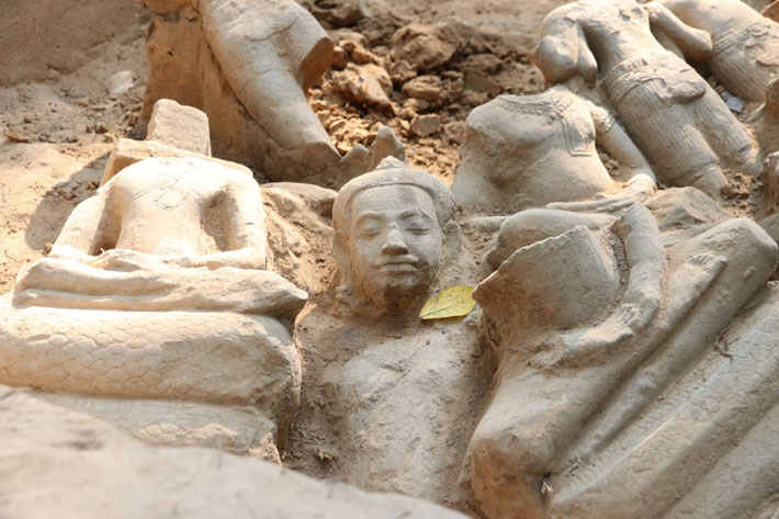
For instance, earlier this year, Xinhua reported that during an excavation at the Ta Prohm temple within the park, archaeologists found more than 100 Buddhist statues.
Buddha was portrayed in these statues in a variety of poses, frequently sitting cross-legged, and in different sizes. They were created in the late 12th and early 13th centuries in the Bayon style, just like the guardian statue.
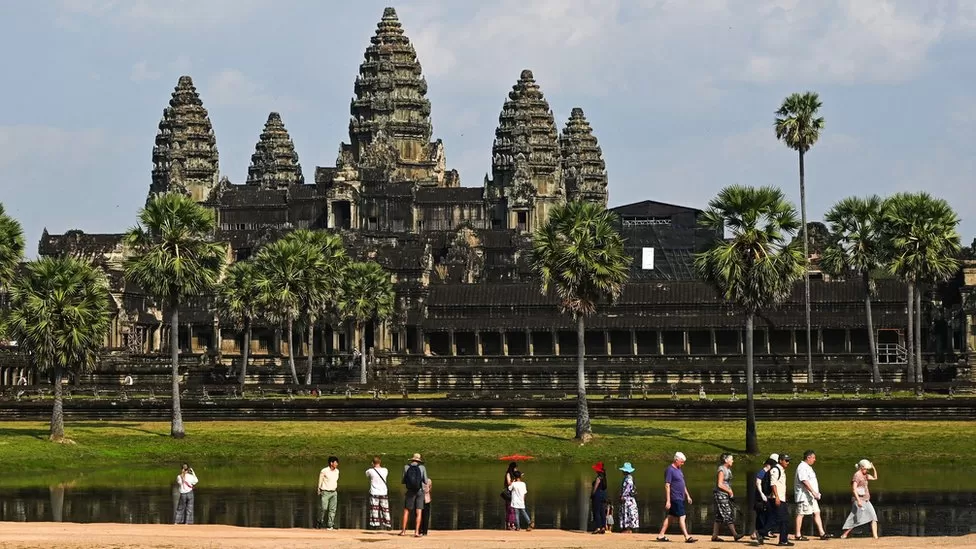
Angkor Wat welcomes hundreds of thousands of tourists each year and has been a UNESCO World Heritage site since 1992.
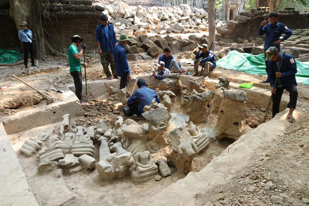
Archaeology specialists from the APSARA National Authority (ANA) are meticulously identifying the dozens of fragments and identifying them. ANA
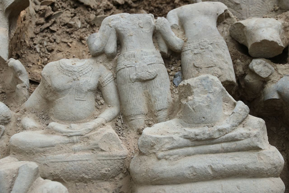
Specialists from the APSARA National Authority (ANA) found more than they bargained for during a recent excavation, with more than 100 pieces of sandstone sculptures uncovered.
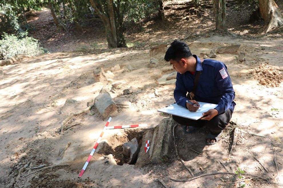
The ANA’s Department of Preservation and Archaeology was conducting the removal of built-up soil from south of the laterite stone wall of Ta Prohm Temple’s third enclosure, while cataloguing each of the stone fragments they discovered.
Ta Prohm is one of the most well-known of the Kingdom’s ancient temples, with the unique combination of soaring trees growing from the crumbling, yet still majestic stones lending an air of romantic exploration.
It is sometimes referred to as the “Tomb Raider Temple”, thanks to the fame it enjoyed as a location for Angelina Jolie’s 2001 eponymous film.
As the soil removal progressed, an unexpected number of significant pieces of ornate carvings were unearthed, some of them buried in as little as 10 to 15 centimetres of soil.
According to ANA archaeologist Neth Simon, the team recognised the importance of their finds, and immediately sought permission to expand the dig site.
One of the APASARA National Authority (ANA) team notes the precise measurements and features of one of the newly discovered national treasures. ANA
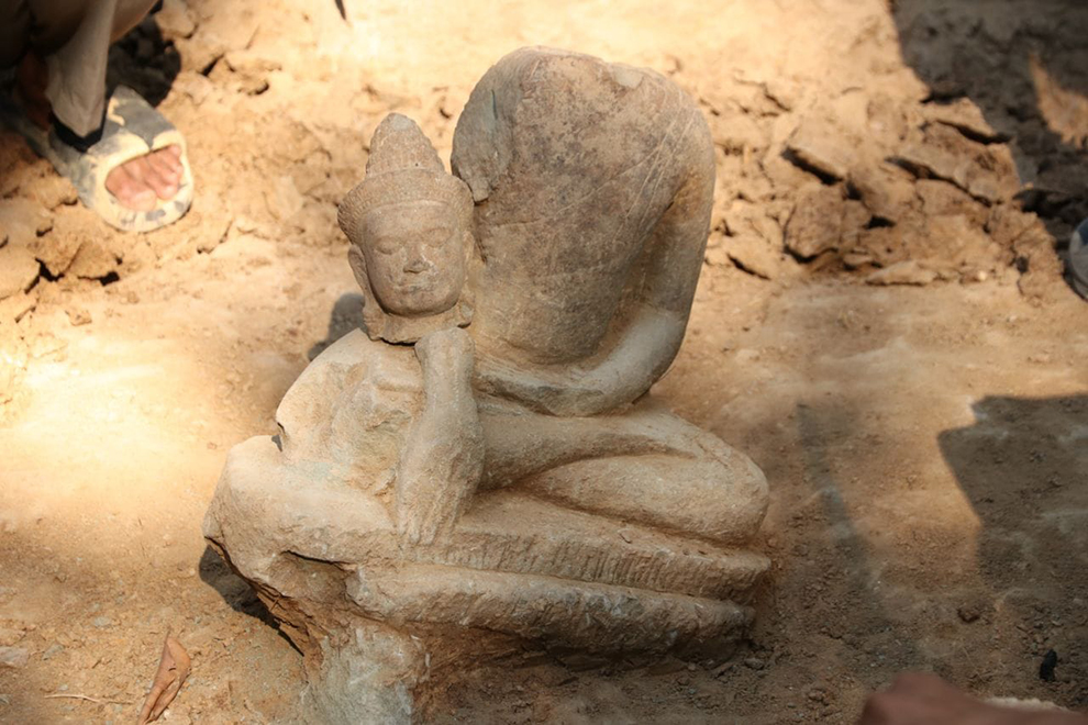
With the approval of the ANA leadership, more serious excavations were undertaken, leading to a treasure trove of rare pieces. Many of the statues are up to 50cm in height, and almost complete. A total of over 100 pieces have been identified, and are currently being measured, weighed and assessed.
According to Simon, some of the sculptures include seated and standing Buddhas, along with Nagas, the spiritual snake-like guardian of ancient Khmer legend.
She explained that although unconfirmed, many of the ANA’s experts have speculated that the statues were carved in the Bayon style, dating from the late 12th or early 13th century.
A close up image shows the detail one of the fragmented statues discovered near the Ta Prohm Temple. ANA
Long Kosal, ANA spokesperson, noted that there are many places in the park where fragments of ancient statues have been found. The pieces remain as clues to the daily lives of people from ancient times.
“We don’t know what remains under the earth in this area. This is why it is necessary to preserve the location,” he said.
As the work continues, one thing is certain. The ancient structures of Siem Reap province’s Angkor Archaeological Park will continue to surprise the modern inhabitants of this ancient land.
Collection of Crown Jewelry Repatriated to Cambodia
Experts are trying to work out what some of the items were used for
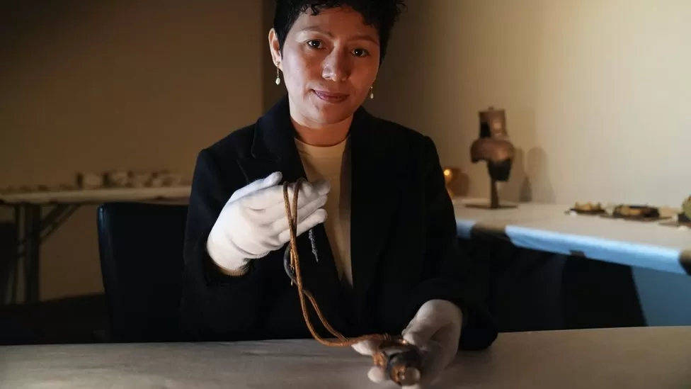
A vast trove of Cambodia’s Angkorian crown jewellery, some dating back to the 7th Century, resurfaced in London last summer, it has been revealed.
The stolen items belonged to British antiquities smuggler Douglas Latchford. Experts say they have never seen most of the jewellery before and are stunned by its existence.
The collection has been secretly returned to Cambodia’s capital, Phnom Penh, and is due to go on display there in the country’s national museum.
Latchford died in 2020 while awaiting trial in the US. His family promised to return his stolen collection to Cambodia after he died, but the authorities did not know what exactly would be handed over or how it would happen.
Brad Gordon, the head of Cambodia’s investigative team, became the first representative of the nation to see the jewellery when he visited London last summer. He told the BBC: “I was driven by a representative of the Latchford family to an undisclosed location. In the parking lot was a vehicle with four boxes inside.
“I felt like crying. I just thought – wow – the crown jewels of ancient Cambodian civilization packed into four boxes in the back of a car.”
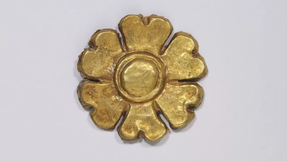
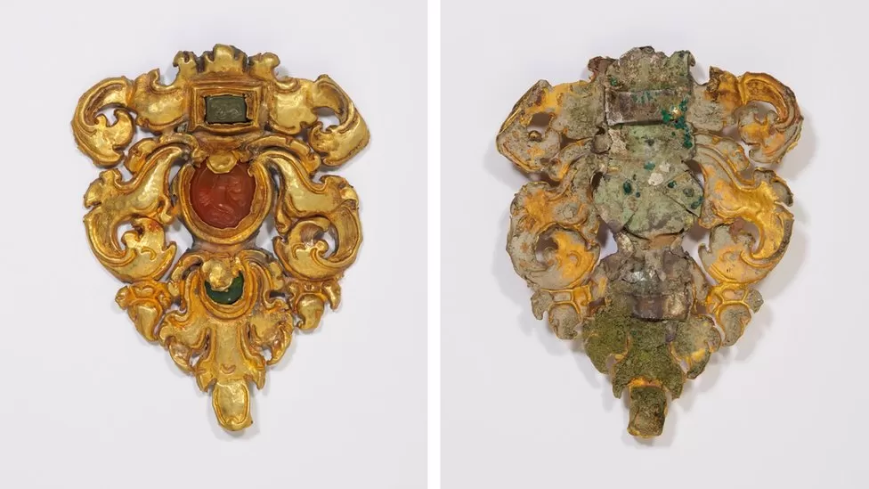
When it was all unwrapped, the resurfaced collection was found to contain 77 pieces of gold and jewel-encrusted jewellery, including crowns, belts and earrings. A large bowl is thought to date to the 11th Century and although it has yet to be tested, appears to be made of solid gold. Experts believe it could have been used as a rice bowl for Angkorian royalty.
It’s possible some of the jewellery was looted from temples such as Angkor Wat
One of the crowns appears to be from the pre-Angkorian period, experts believe, and could have been made by artisans in the 7th Century. Other items, including a small sculpted flower, pose a mystery. Experts simply don’t know why it was made or how it was used.
It’s still unclear exactly how and when the jewellery was stolen and how it made its way to London. Many of the items can be matched to stone carvings in the walls of Angkor Wat, a Unesco World Heritage Site. The largest religious monument in the world, its construction began in 1122 as a dedication to the Hindu god Vishnu, though it transitioned into a Buddhist temple decades later.
Angkor Wat was heavily looted during the French colonial period. However, many of Cambodia’s other temples were looted during the Khmer Rouge era in the 1970s, and the turmoil that continued for decades.
Archaeologist Sonetra Seng studied Angkorian jewellery for years by examining temple carvings. Finally, she can hold the real thing.
“The jewellery proves what was on the carvings and what was rumoured is really true. Cambodia was really, really rich in the past,” she says. “Still, I can’t believe it, especially that it’s from one single collection found abroad.”
Archaeologist Sonetra Seng recognised some of the jewellery from temple carvings
Some of the jewellery had surfaced before; Douglas Latchford included five items from the collection in a book titled Khmer Gold that he co-wrote with his collaborator, Emma Bunker, in 2008. Khmer antiquities expert Ashley Thompson describes this book and two others as elaborate sales brochures, giving private collectors a taste of what was being sold illegally behind the scenes.
“Publishing these materials, inviting other scholars to contribute and comparing the items to museum pieces was a way of validating them and associating them with known materials already in museums and effectively enhancing their value,” she explained.
Ms Thompson, a professor in South East Asian art at SOAS University of London, says it will take a long time for experts to piece together where the newly discovered jewellery really came from because the book contains so many half-truths.
“You certainly can’t take for granted anything that is said about the provenance or the current ownership,” she explained, as she flipped through the book and pointed to the way in which Latchford and Bunker described the ownership of the different pieces of jewellery. “Private Thai collection, private London collection, private New York collection, private Japanese collection etc. You have to be very wary.”
There were 77 items recovered, some made of solid gold and some encrusted with jewels
The Cambodian authorities believe that more Angkorian jewellery is yet to be found. The Cambodians have evidence from Latchford’s email correspondence that he was attempting to secretly sell the collection from a north London warehouse as late as 2019.
We asked London’s Metropolitan Police if Latchford’s UK associates are also being investigated. They declined to comment – noting they do not identify anyone under investigation prior to being charged with a criminal offence.
Last year, the BBC travelled to Cambodia to meet looters turned government witnesses who identified items they say they stole from temples and sold to Latchford. Some of those items have been matched by investigators to museum pieces that are now in respected UK institutions like the British Museum and the V&A.
One of the women the BBC interviewed then – nicknamed Iron Princess – will also work to help identify some of the jewellery.
For now, the collection’s return will be welcomed by the country’s autocratic leader, Hun Sen. An election is coming up in July, and since his ruling party has effectively dismantled the opposition, this development will be painted as something Hun Sen has done to benefit his people.
Politics aside, ordinary Cambodians want all the looted items back. After decades hidden inside dusty boxes, they will soon go on public display in Phnom Penh, allowing this jewellery to shine once again.
Ancient statue unearthed at Cambodia’s Angkor temple complex
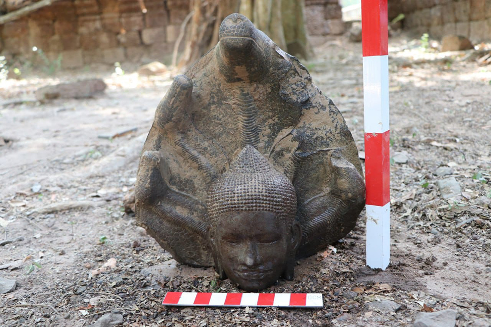
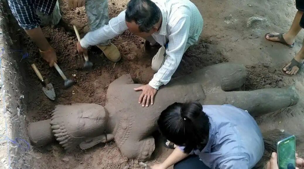
A team of archaeologists has uncovered a large ancient statue that is thought to have once stood as a guard over an ancient hospital to the north of Cambodia’s Angkor Thom city complex.
Impressive Ancient Statue Unearthed in Angkor Thom Complex
The almost two-meters tall statue, which is believed to be from the late 12th to the early 13th century, was spotted during a dig in Siem Reap province last Saturday, as I’m Sokrithy, an archaeologist with the Apsara Authority, the government organization managing Angkor Park, and the dig’s scientific supervisor stated.
“We were very surprised to find this,” he told Cambodia Daily, and added that the sandstone statue is missing its feet and parts of its legs, otherwise it would have stood at least 2.1 meters (in its original form) and weighed in at 200kg (440 pounds).
Archaeologists made a grid to draw the statue which is in the form of a guard, before moving it
The Angkor Archaeological Park is Cambodia’s most popular tourist attraction and a world heritage site due to the many remains it boasts from the different capitals of the Khmer Empire, dating from the 9th to the 15th centuries.
During the peak of its power, the city hosted hundreds of temples and more than a million citizens, making it one of the planet’s most populous pre-industrial cities.
The statue was found next to one of four hospitals which were discovered in Angkor Thon a century ago. It is one of 102 that King Jayavarman VII had constructed in the Angkor empire.
“Jayavarman VII’s reign was truly remarkable in terms of social programs,” he said. “The hospital consisted of wooden buildings and a chapel erected in stones. What is left is the chapel…as wooden structures have long disappeared,” explained Tan Boun Suy, deputy director-general for the Apsara Authority as reported by Cambodia Daily.
The Great Sacred City of Angkor Thom
Angkor Thom (which means ‘Great City’) was the last capital of the mighty Khmer Empire, which was based in modern-day Cambodia. As previously reported in another Ancient Origins article, this typically intricately decorated Khmer city, which is located in Cambodia’s Siem Reap province, was fortified by massive walls, which in turn surrounded a great moat.
In order to enter this protected city, one had to cross one of Angkor Thom’s enormous causeways. As a capital city, Angkor Thom contained numerous important structures, including temples, royal residences, and administrative buildings. Today, Angkor Thom is part of the UNESCO World Heritage Site of Angkor, which also includes the famous Temple of Angkor Wat.
The archaeology team respectfully ask the spirit protecting the site permission to move the statue they unearthed the previous day to the Preah Sihanouk Museum in Siem Reap province.
Angkor Thom was founded around the later part of the 12 th century AD, during the reign of Jayavarman VII, who is often regarded as the greatest king of the Khmer Empire. This city was established following the sacking of the previous capital, Angkor, by the Chams during the reign of Jayavarman’s predecessor.
The layout of Jayavarman’s new capital was in the shape of an almost perfect square, which was separated from the surrounding areas by a circuit of huge walls, and a moat reported to have contained crocodiles.
In order to enter Angkor Thom, a visitor would need to pass through one of the five monumental gates that are found along the city walls. The northern, southern and western walls each have a gate, whilst the eastern one has two.
Additionally, these gates are reached via causeways that cross the moat. These causeways are flanked by 54 statues on each side, demons on the right, and gods on the left.
The demons may be identified by their fearsome facial expressions and military headdresses, whilst the gods look calm and are wearing conical headdresses. At the beginning of each causeway is the statue of a nine-headed serpent, whose body is held by the gods and demons. This arrangement depicts the famous Hindu myth known as the ‘Churning of the Ocean’.
Statues at the South Gate of Angkor Thom in Cambodia, with gods holding the 9-headed serpent.
Angkor Thom Today and the Importance of Recent Find
In recent years, vast parts of the park have been excavated, creating a marvellous archaeological walking path that attracts more than two million visitors a year. However, the famed complex of the historic city still remains a mystery that hasn’t been fully explored.
The recent finding is clear proof of this. Maybe that’s why when the Cambodian archaeologists from Singapore’s Institute of Southeast Asian Studies found the beautiful statue buried only 40 centimetres under the ground of the Angkor-era hospital, they couldn’t believe their eyes. As Cambodia Daily reports, archaeologists now suggest that the statue most likely served as a symbolic guardian of the hospital and hope that the excavation will unearth more objects from that era, which could shed light on the daily life and activities in those hospitals and also the lives of ordinary people of the era.
The excavation is conducted by the Apsara Authority in cooperation with the Institute of Southeast Asian Studies’ Yusof Ishak Institute in Singapore. As part of a training program, ten students from Asian countries, the U.S. and Australia are taking part in the excavation.
(This August story corrects the 6th paragraph to state that Douglas Latchford was a dual citizen of Thailand and the United Kingdom, not Thailand and the United States)
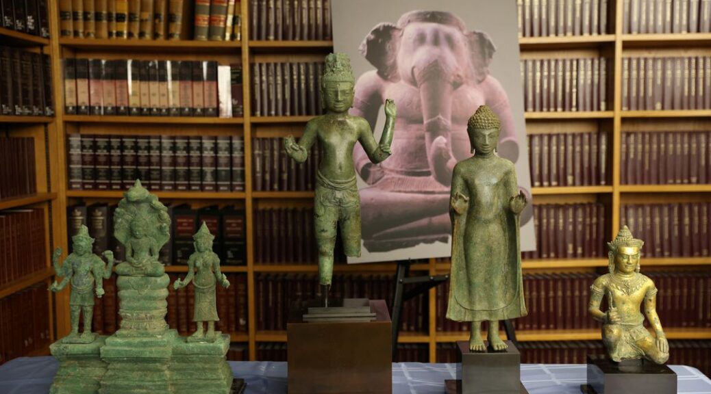
The United States will return to Cambodia 30 looted antiquities, including bronze and stone statues of Buddhist and Hindu deities carved more than 1,000 years ago, U.S. officials said on Monday.
The Southeast Asian country’s archaeological sites – including Koh Ker, the capital of the ancient Khmer empire – suffered widespread looting in civil conflicts between the 1960s and 1990s.
Cambodia’s government has since sought to repatriate stolen antiquities sold on the international market.
Damian Williams, the top federal prosecutor in Manhattan, said the items being returned were sold to Western buyers by Douglas Latchford, a Bangkok dealer who created fake documents to conceal that the items had been looted and smuggled.
Williams said the antiquities, including a 10th-century sandstone statue depicting the Hindu god of war Skanda riding on a peacock, were voluntarily relinquished by U.S. museums and private collectors after his office filed civil forfeiture claims.
Seized items are displayed during an announcement of the repatriation and return to Cambodia of 30 Cambodian antiquities sold to U.S. collectors and institutions by Douglas Latchford and seized by the U.S. Attorney’s Office in Manhattan, New York City, U.S., August 8, 2022.
A person looks at a seized 10th Century Khmer sandstone statue of Skanda on a Peacock following an announcement of the repatriation and return to Cambodia of 30 Cambodian antiquities sold to U.S. collectors and institutions by Douglas Latchford and seized by the U.S. Attorney’s Office in Manhattan, New York City, U.S., August 8, 2022.
A 10th-century Koh Ker-style sandstone sculpture of a Yaksha is prepared ahead of an announcement of the repatriation and return to Cambodia of 30 Cambodian antiquities sold to U.S. collectors and institutions by Douglas Latchford and seized by the U.S. Attorney’s Office in Manhattan, New York City, U.S., August 8, 2022.
Lee Satterfield, Assistant Secretary of State for the Bureau of Educational and Cultural Affairs at the U.S. State Department delivers remarks as he stands with seized items during an announcement of the repatriation and return to Cambodia of 30 Cambodian antiquities sold to U.S. collectors and institutions by Douglas Latchford and seized by the U.S. Attorney’s Office in Manhattan, New York City, U.S., August 8, 2022.
“These statues and artefacts… are of extraordinary cultural value to the Cambodian people,” Williams said at a ceremony in Manhattan announcing the return of the antiquities.
U.S. prosecutors in 2019 charged Latchford, a dual citizen of Thailand and the United Kingdom, with wire fraud and smuggling over the alleged looting. He died in Thailand in 2020.
The antiquities will be displayed at the National Museum of Cambodia in Phnom Penh, Cambodia’s U.S. ambassador Keo Chhea told Reuters at the ceremony.
In 2014, federal prosecutors returned the Duryodhana, a looted 10th-century sandstone sculpture, to Cambodia after settling with auction house Sotheby’s Inc, which had acquired it.
Last year, the Manhattan district attorney’s office returned 27 looted antiquities to Cambodia.
Revealed: Cambodia’s vast medieval cities hidden beneath the jungle
Archaeologists in Cambodia have found multiple, previously undocumented medieval cities not far from the ancient temple city of Angkor Wat, the Guardian can reveal, in groundbreaking discoveries that promise to upend key assumptions about south-east Asia’s history.
The Australian archaeologist Dr Damian Evans, whose findings will be published in the Journal of Archaeological Science, will announce that cutting-edge airborne laser scanning technology has revealed multiple cities between 900 and 1,400 years old beneath the tropical forest floor, some of which rival the size of Cambodia’s capital, Phnom Penh.
Invisible city
For centuries, the Angkor region’s wealth of artefacts drew looters, archaeologists. They focused their attention, both good and ill, on Angkor Wat and a few other nearby moated temple complexes. Based on those ruins, the first European explorers to encounter Angkor in the 19th century assumed Khmer urbanites lived in what were basically moated cities of a few thousand people. These European explorers thought Angkor Wat was something like a medieval walled city in Europe, which typically held fewer than 10,000 people. They explained all the moated complexes in the Angkor area by suggesting that maybe the royal family and their people were moving from one moated city to the next overtime. But as archaeologists learned more in the intervening century, something about those population numbers seemed off. Beyond the moated cities were vast canal systems and reservoirs hinting at something bigger.
The ruins of Preah Khan of Kompong Svay covered with forest. An urban network was revealed by the lidar imagery around this temple.
Unfortunately, most of Angkor had become a tangle of jungles and small farms by the 20th century. There was little evidence of medieval settlements beyond the moats’ precise edges. Even if explorers were willing to hack through the dense growth, there was little to find. In a Khmer city, only the temples were made from stone. Everything else was built from perishable materials like wood. All that remained of Angkor’s homes and other non-religious structures were the elevated clay mounds of their foundations, which had been designed to prevent flooding during Cambodia’s intense wet season. Most of the city’s dramatic waterworks for flood runoff and water storage had been reduced to pits and troughs in the Earth. It was practically impossible to identify a medieval Angkorian house deep within the jungle.
All that changed when airborne LiDAR (for “Light Imaging, Detection, And Ranging”) came into common use for mapping in the early 2000s. Archaeologists working in Cambodia immediately seized on it. By scattering light off the surface of the planet, LiDAR systems can produce maps with accuracy down to the centimetre even if the ground is covered in heavy vegetation. The system is ideal for a place like Angkor, where the city’s remains are cloaked in vegetation and characterized almost entirely by elevated or depressed plots of ground.
The LiDAR rig was a Leica ALS70 HP instrument, mounted in a pod attached to the right skid of a Eurocopter AS350 B2 helicopter along with a 60 megapixel Leica RCD30 camera.
With funding from the National Geographic Society and European Research council, archaeologist Damian Evans and his colleagues conducted broad LiDAR surveys of Angkor in 2012 and 2015. The team’s mapping rig consisted of a Leica ALS70 HP LiDAR instrument mounted in a pod attached to the right skid of a Eurocopter AS350 B2 helicopter alongside a 60 megapixel Leica RCD30 camera. It was as if an invisible city suddenly appeared where only overgrowth and farmland existed before. For the first time in centuries, people could discern Angkor’s original urban grid. And what they saw changed our understanding of global history.
Archaeological researcher Piphal Heng, who studies Cambodian settlement history, told Ars that the LiDAR maps peeled back the forest canopy to reveal meticulous grids of highways and low-density neighbourhoods of thousands of houses and pools of water. There was “a complex urban grid system that extended outside the walls of Angkor Thom and other large temple complexes such as Angkor Wat,Preah Khan, and Ta Prohm,” he said. With the new data, scientists had solid evidence that the city of Angkor sprawled over an area of at least 40 to 50 square km. It was home to almost a million people. The scattered, moated complexes like Angkor Wat and Angkor Thom were merely the most enduring features of what we now know was the biggest city on Earth during the 12th and 13th centuries.
This aerial photo shows what Angkor Wat looks like today, surrounded by vegetation and a few areas of modern farms and homes. None of the vast city grid from 800 years ago is visible.
In the LiDAR map, you can clearly see the central urban grid of Angkor extending from Angkor Thom (top left) and Angkor Wat (bottom left).
Here you can see the areas covered by the LiDAR surveys in 2012 and 2015.
A map of the greater Angkor area, showing the extent of the urban sprawl revealed by LiDAR.
From legend to reality
The city of Angkor has its origins in the ninth century during the reign of Jayavarman II. He unified large parts of Southeast Asia by establishing the Khmer Empire across regions we know today as Cambodia, Thailand, Vietnam, and Laos. Inscriptions on temple walls at Sadok Kok Thom in Thailand describe how he established a city called Hariharalaya, located near Siem Reap in the Angkor area. But the inscriptions also say that Jayavarman II declared himself a supreme ruler or “god-king” in a lavish Hindu ceremony held at his residence on Kulen Mountain in a city called Mahendraparvata. Accounts of the Kulen Mountain phase in Jayavarman’s life are so sparse and fantastical that debates have raged among scholars about whether he actually lived in Mahendraparvata at all.
To find out more, archaeologists targeted Kulen Mountain in their latest LiDAR survey. Evans published some of the first results from this 2015 survey in the Journal of Archaeological Science. Royal Academy of Cambodia archaeologist Kaseka Phon explained to Ars via e-mail that the LiDAR has uncovered an Angkor-like city grid at the abandoned city of Mahendraparvata on Kulen Mountain. Plus, the LiDAR “shows not only features of the construction, but also water features” that are clearly versions of Angkor’s incredible water management facilities. The new survey revealed massive stone quarries, now filled in, that produced the rock used to build some of the temples of Angkor. Kulen Mountain’s role in the birth of the Khmer Empire is no longer a legend—it’s an established historical fact.
This transformation of legend into fact has been a theme of the LiDAR surveys. Angkor’s huge population is described in temple inscriptions and reports written by Chinese travellers who visited the city during the 12th-century reign of King Suryavarman II, who built Angkor Wat. But historical sources are often exaggerated or incomplete. Plus, it was difficult for Western researchers to believe that the Khmer Empire’s great city was home to almost a million people, dwarfing European cities of the same era. Now, such facts are impossible to deny.
Angkor city planning
Angkor reached megacity proportions in the 12th century when Suryavarman II ordered the construction of Angkor Wat (which he dedicated to the Hindu god Vishnu). At that time, the urban sprawl in Angkor was not only enormous, but it was centrally planned with rigorous precision. Heng told Ars that “the shape of roads, walls, moats, mounds, and ponds were probably made based on urban templates commissioned by the Angkorian rulers” while residents of different neighbourhoods probably had different degrees of freedom to modify those plans. Heng continued:
At temples such as Angkor Wat and Ta Prohm, the grid usage was significantly varied. For example, based on our recent excavations, after the urban grid was laid out, there is little evidence of modification—if at all—in a series of habitation mounds inside Angkor Wat. While for Ta Prohm, its inhabitants seem to have more freedom in modifying parts of their gridded mounds.
To learn more about everyday life in Angkor Wat, University of Illinois Urbana-Champaign archaeologist Alison Carter has done excavation work on some of the residential mounds inside the enclosure. In 2015, she got funding from the National Geographic Society to excavate one of the residential mounds identified via LiDAR. Carter discovered what appears to be the remains of a brick stove, complete with ceramic vessels for cooking. Chemical analysis revealed remains of pomelo fruit rind, seeds from a relative of the ginger plant, and grains of rice. This is what archaeologists call “ground-truthing,” and it’s further confirmation that the mounds we see in LiDAR are actually from households rather than other structures.
The picture that’s emerging of Angkor is much like a modern low-density city with mixed-use residential and farm areas. As Evans put it to Ars, “in the densely inhabited downtown core there are no fields, but that nice, formally planned city centre gradually gives way to an extended agro-urban hinterland where neighbourhoods are intermingled with rice-growing areas, and there is no clear distinction between what is ‘urban’ or ‘rural’.” The city was a miracle of geoengineering with every acre transformed by human hands, whether for agriculture or architecture.
Perhaps Angkor’s greatest technological achievement was its sophisticated waterworks, including artificial canals and reservoirs. People strolling through the city 800 years ago would have passed through neighborhoods whose carefully arranged homes were built alongside rainfall ponds for families, as well as enormous canals for the city as a whole. Massive rectangular reservoirs held water all year around for agricultural use.
Each neighbourhood would have looked slightly different, though all relied on the same water infrastructure. The city had to survive the floods of the rainy season and slake the thirst of people and farms in the dry season. For centuries, it accomplished this incredible feat, which modern cities still struggle with. Suryavarman II ruled a city whose mythic proportions were enabled by the most sophisticated engineering techniques of his day.
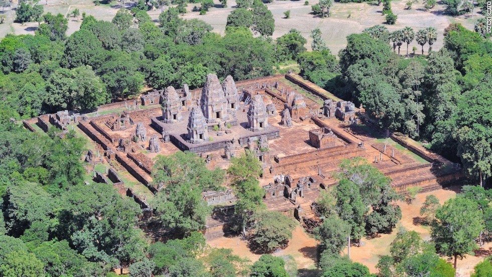
Comparison of major temple complexes in the 12th to 13th centuries, all at the same scale. Later developments (right column) show more variable grids than earlier ones (left column), with areas within the moat divided neatly into ~100×100 m “city blocks.” 6a: Angkor Wat. 6b: Beng Mealea. 6c: Preah Khan of Kompong Svay. 6d: Preah Khan of Angkor. 6e: Ta Prohm. 6f: Banteay Chhmar.
“Mound fields” across Cambodia. Panels a,b are in the Phnom Kulen area. Panels c,d are immediately to the north of the main temple complex at Sambor Prei Kuk. Panels e,f are Immediately to the west of Banteay Srei temple at Angkor. Panels g,h: Near the exit of the East Baray reservoir at Angkor, new archaeological mapping (3g) based on the 2012 ALS data has added further detail to a ~10×10 grid of mounds (3h) and revealed a second mound field to the south of the exit. Panels 3a,c and e are conventional aerial imagery acquired in the 2015 campaign. Panel 3g is based on archaeological maps by Damian Evans, Christophe Pottier and Pelle Wijker.
Unexplained, rectangular coil patterns associated with major temples across northwest Cambodia, revealed in LiDAR maps.
Mysterious coils and mounds
Plenty of unknowns remain at Angkor, and the LiDAR surveys have revealed two previously unseen structures that nobody has been able to explain so far. The first is a complicated rectangular maze pattern dubbed the “coils,” “spirals,” or “geoglyphs.” These were first spotted outside the moat at Angkor Wat during the 2012 survey, but the 2015 survey revealed similar coils outside the enclosures at Beng Mealea and Preah Khan. At first glance, they appear to be waterworks, but Evans and his colleagues dismissed that idea because they are too shallow and are cut off from the city’s general waterworks.
Currently, the reigning hypothesis is that these rectilinear coils were specialized gardens for growing plants used in temple rituals. The often-flooded channels might have contained lotus, while the raised areas could have supported “aromatics such as sandalwood trees.”
More mysterious are the so-called “mound fields” found near some of Angkor’s largest reservoirs and canals. Unlike the residential mounds excavated by Carter and her colleagues, these mounds aren’t packed with ceramics and food remains. They are just mounds, clearly the foundations for an elevated structure or structures. Their locations suggest that they may have been related to the city’s waterworks, but of course, correlation does not equal causation. Further research is needed to unlock the secrets of the coils and mound fields.
Sprawling Remains of Ancient Cities Discovered Beneath Cambodia’s Jungle
Every year, hundreds of thousands of tourists from around the world flock to visit the famed Angkor Wat temple in Cambodia. However, as exploration has uncovered evidence of mediaeval settlements under the jungle, it suggests that there will soon be new places to explore.
To shed new light on the society behind the world’s largest religious complex, researchers used laser technologies. Although the analysis has been ongoing for many years, the new findings uncover the sheer scale of the Khmer Empire’s urban sprawl and temple complexes to be significantly bigger than was previously thought.
Damian Evans and colleagues say they find evidence of extensive networks circling the colossal stone temple complex at Angkor Wat by using high-tech lasers to search the Cambodian jungle.
In 2012, the airborne Lidar system revealed a long-forgotten urban landscape in the jungle of Cambodia. The new research now reveals the sheer size of the ancient cities
Evans said their findings could further our understanding of Khmer culture and throw into question traditional assumptions about the 15th-century decline of the empire. Evans said a laser technology known as lidar was used to create precise maps of ancient networks that left only vague traces – invisible to the naked eye – in the landscape surrounding the temples.
‘You could be standing in the middle of the forest looking at what appear to be some random lumps and bumps,’ Evans said.
‘But they might actually be evidence of old excavated ponds or built-up roadways,’ he explained. ‘All of these things left traces in the surface of the landscape that wouldn’t make sense to you without a more detailed picture.’
To obtain such details, Evans said his colleagues spent 90 hours in a helicopter directing laser scans into the jungle surrounding Angkor Wat. He said that the resulting images are so intricate ‘you can see objects lying next to a tiny anthill.’
The research was published in the Journal of Archaeological Science. It was the result of a joint project including the French Institute of Asian Studies in Paris, the Cambodian national authority responsible for protecting Angkor Wat and the ministry of culture and fine arts.
New images from the survey show ancient cities near Angkor Wat were much bigger than previously thought. Above, a shaded relief map of the terrain around the central monuments of Sambor Prei Kuk
Angkor Wat, a UNESCO World Heritage site, is considered one of the ancient wonders of the world. It was constructed from the early to mid 1100s by King Suryavarman II at the height of the Khmer Empire’s political and military power and was among the largest pre-industrial cities in the world
For years, experts have assumed that the ancient Khmer civilization collapsed in the 15th century when invading Thai armies sacked Angkor Wat, forcing populations to relocate to southern Cambodia. But Evans said their laser maps showed no evidence of relocated, dense cities in the south and that it wasn’t clear there was any such mass migration.
Chanratana Chen, a Cambodian academic at the University of Sorbonne in Paris, said the new findings had changed his own perception of the Angkor Wat temple complex, which the Cambodian people commonly refer to as ‘the small city.’ Chen was not involved in the new research.
‘The new results (show) us that Cambodia was a much more advanced civilization than we thought, especially about the management plan of the city and irrigation system to improve agriculture in the area,’ Chen wrote in an email.
Among the most noteworthy discoveries, Evans and colleagues had found were proof of medieval sandstone quarries and traces of a royal road between various temple complexes, he said.
In 2012, the team discovered 1,200-year-old statues and temples. This research now builds upon those findings
Evans doubted tourists would soon be flocking to see the unremarkable ‘mounds in the ground’ that the lasers had decoded at Angkor Wat. But said he and colleagues have now pinpointed sites that might be fruitful for further excavation.
He said it was likely there could be similar such discoveries elsewhere in Southeast Asia, possibly in Burma and even the Americas, where archaeologists might unearth more secrets about the remains left behind by the 6th-century Mayan Empire.
Angkor Wat, a UNESCO World Heritage site, is considered one of the ancient wonders of the world. It was constructed from the early to mid-1100s by King Suryavarman II at the height of the Khmer Empire’s political and military power and was among the largest pre-industrial cities in the world.
The new findings build on scans that were made in 2012 that confirmed the existence of Mahendraparvata, an ancient temple city near Angkor Wat. However, until now, the sheer scale of the settlements was unknown.
Mr Chhay Rachna, of Cambodia’s APSARA National Authority, oversees excavations at the geometric features uncovered near Angkor Wat, guided by the lidar imagery
The new findings build on scans that were made in 2012 (pictured) that confirmed the existence of Mahendraparvata, an ancient temple city near Angkor Wat. However, until now, the sheer scale of the settlements has remained unknown
Mr Evans said: ‘What we had was basically a scatter of disconnected points on the map denoting temple sites. Now it’s like having a detailed street map of the entire city.’
Further maps will be published in the coming months. Long Kosal, a spokesman for the Apsara Authority, the government body that manages the Angkor complex, said the lidar had uncovered ‘a lot of information from the past.’
He said: ‘It shows the size and information about people living at those sites in the past,’ but added that further research was now needed to capitalise on the finds. While the Khmer Empire was initially Hindu it increasingly adopted Buddhism and both religions can be seen on display at the complex. Angkor is visited by hundreds of thousands of visitors a year and remains Cambodia’s top tourist attraction.
The information has helped archaeologists to map out the area and will help increase the accuracy of future digs. Pictured above, terrain in the mountains to the north of Angkor.
This digital terrain model of Preah Khan of Kompong Svay in Cambodia was taken using lidar
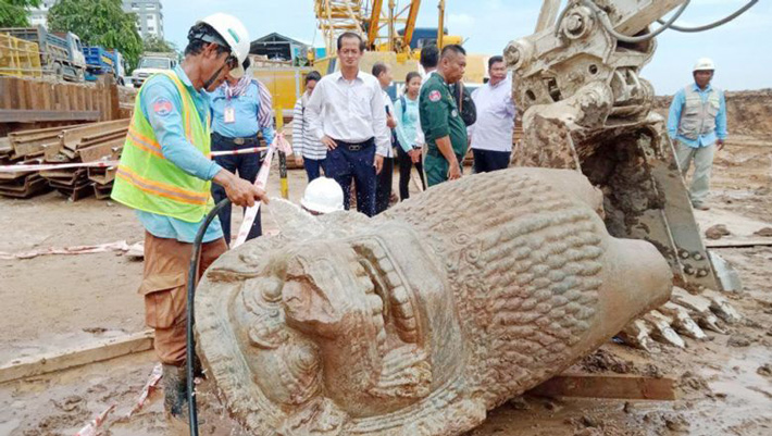
According to a report in The Phnom Penh Post, two pieces of a six-foot-tall statue of a lion were unearthed by mine-clearing experts preparing the site of a new groundwater reservoir along the Tonle Sap River.
The crew members excavated and cleared mines for a planned groundwater reservoir that will also be the site of Phnom Penh’s sixth water pumping station. It is located along the Tonle Sap River in front of the Council for the Development of Cambodia, according to Ratana.
After digging the soil up to 4 m underground lion statue was discovered, separated into two parts. At the National Museum, the Ministry will retain it, “he added.
A statue of a lion was found by mine clearance experts while they were digging for a development project along the Tonle Sap River in Phnom Penh’s Daun Penh district. CMAC
Ratana said it is not CMAC’s duty to care for the statue, so the organization will leave it to the proper authorities to preserve it.
The director-general for tangible heritage at the ministry, Hab Touch, told The Post on Tuesday that he had not seen the statue yet. A press release he received said the statue resembles the lion statue at Wat Phnom.
But Touch said: “I don’t think it’s a lion from Wat Phnom because that lion is large. Its location means there must be something there like a bridge.”
Phnom Penh Department of Culture director Chum Vuthy told The Post on Tuesday that the ministry hasn’t studied the statue yet.
“This matter should be brought to the museum and the Ministry of Culture and Fine Arts, which took this statue to study it. There is an experiment center in the museum,” he said.
National Museum director Chhay Visoth told The Post that he cannot make any assumptions about which era the stone lion was made in because experts needed time to check the composition of the ancient stone.
“We cannot make assumptions of the lion that we found during mine clearance for the reservoir plan because we don’t have any connections regarding this statue.
“Normally, we can know the date of an artefact by identifying other things around it,” he said.
Viosth said it’s suspected that the lion was created at the same time as Wat Phnom or sometime after Cambodia was a French protectorate.
He said the statue also could have been taken from other areas such as Angkor.
“We suspect that it could have been from the Bakheng Mountain area because its height is 2m. We need time to study and date it,” he said.