Lost cities of the Amazon featuring terraces and PYRAMIDS are discovered
A massive urban landscape that contained interconnected campsites, villages, towns and monumental centres thrived in the Amazon rainforest more than 600 years ago.
In what is now Bolivia, members of the Casarabe culture built an urban system that included straight, raised causeways running for several kilometres, canals and reservoirs, researchers report May 25 in Nature.
Such low-density urban sprawl from pre-Columbian times was previously unknown in the Amazon or anywhere else in South America, say archaeologist Heiko Prümers of the German Archaeological Institute in Bonn and colleagues.
Rather than constructing huge cities densely packed with people, a substantial Casarabe population spread out in a network of small to medium-sized settlements that incorporated plenty of open space for farming, the scientists conclude.
Airborne lasers peered through dense trees and ground cover to identify structures from that low-density urban network that have long eluded land-based archaeologists.
Earlier excavations indicated that Casarabe maize farmers, fishers and hunters inhabited an area of 4,500 square kilometres. For about a century, researchers have known that Casarabe people fashioned elaborate pottery and constructed large earthen mounds, causeways and ponds. But these finds were located at isolated forest sites that are difficult to excavate, leaving the reasons for mound-building and the nature of Casarabe society, which existed from about the year 500 to 1400, a mystery.
Prümers’ team opted to look through the Amazon’s lush cover from above, aiming to find relics of human activity that typically remain hidden even after careful ground surveys.
The scientists used a helicopter carrying special equipment to fire laser pulses at the Amazon forest as well as stretches of grassland. Those laser pulses reflect data from the Earth’s surface. This technique, called light detection and ranging, or lidar for short, enables researchers to map the contours of now-obscured structures.
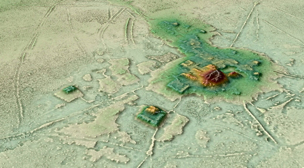
Looking at the new lidar images, “it is obvious that the mounds are platforms and pyramids standing on artificial terraces at the centre of well-planned settlements,” Prümers says.


Prümers’ team conducted lidar surveys over six parts of ancient Casarabe territory. The lidar data revealed 26 sites, 11 of them previously unknown.
Two sites, Cotoca and Landívar, are much larger than the rest. Both settlements feature rectangular and U-shaped platform mounds and cone-shaped earthen pyramids atop artificial terraces. Curved moats and defensive walls border each site.
Causeways radiate out from Cotoca and Landívar in all directions, connecting those primary sites to smaller sites with fewer platform mounds that then link up to what were probably small campsites or areas for specialized activities, such as butchering prey.

The Casarabe society’s network of settlements joins other ancient and present-day examples of low-density urban sprawl around the world, says archaeologist Roland Fletcher of the University of Sydney.
These sites raise questions about whether only places with centralized governments that ruled over people who were packed into neighbourhoods on narrow streets, such as 6,000-year-old Mesopotamian metropolises, can be defined as cities.
Some past urban settlements organized around crop growing spanned up to 1,000 square kilometres or more in tropical regions. These include locales such as Southeast Asia’s Greater Angkor roughly 700 to 800 years ago and interconnected Maya sites in Central America dating to at least 2,300 years ago. Today, extended areas outside large cities, especially in Southeast Asia, mix industrial and agricultural activities over tens of thousands of kilometres.
Clusters of interconnected Casarabe settlements ranged in area from 100 square kilometres to more than 500 square kilometres. Spread-out settlements of the comparable areas include 6,000-year-old sites from Eastern Europe’s Trypillia culture.
Tropical forests that have gone largely unexplored, such as Central Africa’s Congo Basin, probably hosted other early forms of low-density urban development, Fletcher predicts.
Only further excavations guided by lidar evidence can begin to untangle the size of the Casarabe population, Prümers says. Whether primary Casarabe sites represented seats of power in states with upper and lower classes also remains unknown, he adds.
Casarabe culture’s urban sprawl must have encompassed a considerable number of people in the centuries before the Spanish arrived and Indigenous population numbers plummeted, largely due to diseases, forced labour and slavery says archaeologist John Walker of the University of Central Florida in Orlando.
Whatever Casarabe honchos had in mind as their tropical settlement network spread, he says, “we may have to set aside some of our strongly held ideas about what the Amazon is, and what a city is, to better understand what happened.”