Category Archives: AFRICA

New Discovery Reveals Why And When The Sahara Desert Was Green

New Discovery Reveals Why And When The Sahara Desert Was Green

A pioneering study has shed new light on North African humid periods that have occurred over the past 800,000 years and explains why the Sahara Desert was periodically green.

New Discovery Reveals Why And When The Sahara Desert Was Green

The research, published in Nature Communications, showed periodic wet phases in the Sahara were driven by changes in Earth’s orbit around the sun and were suppressed during the ice ages.

For the first time, climate scientists simulated the historic intervals of ‘greening’ of the Sahara, offering evidence for how the timing and intensity of these humid events were also influenced remotely by the effects of large, distant, high-latitude ice sheets in the Northern Hemisphere.

Lead author Dr. Edward Armstrong, a climate scientist at the University of Helsinki and University of Bristol, said, “The cyclic transformation of the Sahara Desert into savannah and woodland ecosystems is one of the most remarkable environmental changes on the planet.”

“Our study is one of the first climate modeling studies to simulate the African Humid Periods with comparable magnitude to what the paleoclimate observations indicate, revealing why and when these events occurred.”

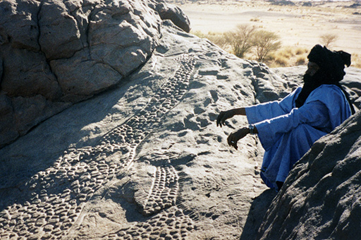
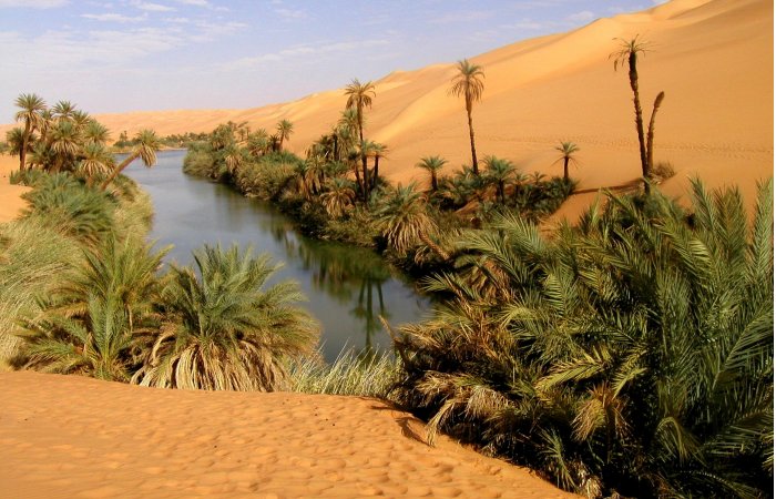
There is widespread evidence that the Sahara was periodically vegetated in the past, with the proliferation of rivers, lakes and water-dependent animals such as hippos, before it became what is now desert.

These North African Humid Periods may have been crucial in providing vegetated corridors out of Africa, allowing the dispersal of various species, including early humans, around the world.

The so-called “greenings” are thought to have been driven by changes in Earth’s orbital conditions, specifically Earth’s orbital precession. Precession refers to how Earth wobbles on its axis, which influences seasonality (i.e., the seasonal contrast) over an approximate 21,000-year cycle. These changes in precession determine the amount of energy received by the Earth in different seasons, which in turn controls the strength of the African Monsoon and the spread of vegetation across this vast region.

A major barrier to understanding these events is that the majority of climate models have been unable to simulate the amplitude of these humid periods, so the specific mechanisms driving them have remained uncertain.

This study deployed a recently-developed climate model to simulate the North African Humid periods to greatly advance understanding of their driving mechanisms.

The results confirm the North African Humid Periods occurred every 21,000 years and were determined by changes in Earth’s orbital precession. This caused warmer summers in the Northern Hemisphere, which intensified the strength of the West African Monsoon system and increased Saharan precipitation, resulting in the spread of savannah-type vegetation across the desert.

The findings also show the humid periods did not occur during the ice ages, when there were large glacial ice sheets covering much of the high latitudes. This is because these vast ice sheets cooled the atmosphere and suppressed the tendency for the African monsoon system to expand.

This highlights a major teleconnection between these distant regions, which may have restricted the dispersal of species, including humans, out of Africa during the glacial periods of the last 800,000 years.

Co-author Paul Valdes, Professor of Physical Geography at the University of Bristol, said, “We are really excited about the results. Traditionally, climate models have struggled to represent the extent of the ‘greening’ of the Sahara. Our revised model successfully represents past changes and also gives us confidence in their ability to understand future change.”

Changes of vegetation between humid and arid phases in North Africa. Vegetation zones are based on the minimum precipitation requirements of each vegetation type.

The research, including climate scientists from the University of Birmingham, is part of a project at the University of Helsinki, which studies the impacts of climate on past human distributions and evolution of their ecological niche.

Co-author Miikka Tallavaara, Assistant Professor of Hominin Environments at the University of Helsinki, said, “The Sahara region is kind of a gate controlling the dispersal of species between both North and Sub-Saharan Africa, and in and out of the continent.”

“The gate was open when Sahara was green and closed when deserts prevailed. This alternation of humid and arid phases had major consequences for the dispersal and evolution of species in Africa.

Our ability to model North African Humid periods is a major achievement and means we are now also better able to model human distributions and understand the evolution of our genus in Africa.”

Ancient Footprints Offer Evidence Humans Wore Shoes 148,000 Years Ago

Ancient Footprints Offer Evidence Humans Wore Shoes 148,000 Years Ago

A new analysis of ancient footprints in South Africa suggests that the humans who made these tracks might have been wearing hard-soled sandals.

Ancient Footprints Offer Evidence Humans Wore Shoes 148,000 Years Ago

Ichnological evidence from three palaeosurfaces on the Cape Coast, in conjunction with a neoichnological study, suggests that humans may indeed have worn footwear while traversing dune surfaces during the Middle Stone Age.

The study is published in the journal Ichnos.

While researchers are reluctant to shoehorn in any firm conclusions regarding the use of footwear in the distant past, the prints’ unusual characteristics may provide the oldest evidence yet that people used shoes to protect their feet from sharp rocks in the Middle Stone Age.

No direct dates have been assigned to the well-preserved markings found on stone slabs at three different sites along the Cape Coast, according to the study’s authors.

However, the researchers hypothesize that tracks discovered at a location known as Kleinkrantz may be between 79,000 and 148,000 years old based on the age of other nearby rocks and sediments.

The footprints show no toes, discerning it from barefoot markings, and instead displayed “rounded anterior ends, crisp margins, and possible evidence of strap attachment points.’ Similar markings that are estimated to have been left between 73,000 and 136,000 years ago were located at a site called Goukamma.

These prints can offer evidence early humans wore footwear 150,000 years ago.

The study authors wrote: “In all cases the purported tracks have dimensions that are broadly consistent with those of hominin tracks.” They added that the “track sizes appear to correspond to the tracks either of juvenile track-makers, or else small-adult hominin track-makers.”

To test this conclusion, the researchers made their own footprints wearing sandals resembling two different pairs of shoes used historically by the Indigenous San people of southern Africa, both of which are currently housed in museums.

Experiments revealed that the use of hard-soled footwear on wet sand left prints with crisp edges, no toe prints, and indentations where the leather straps met the sole – just like the markings at Kleinkrantz.

“While we do not consider the evidence conclusive, we interpret the three sites […] as suggesting the presence of shod-hominin trackmakers using hard-soled sandals,” write the researchers. Offering a possible motive for the use of such footwear, they go on to explain that coastal foraging involves clambering over sharp rocks while also posing the risk of stepping on sea urchins.

“In the [Middle Stone Age], a significant foot laceration might have been a death sentence,” they say. In this scenario, sandals would have been a lifesaver.

Despite their promising findings, researchers are reluctant to make any bold claims. This is due to a variety of factors, such as the difficulty of interpreting rock markings, as well as the fact no actual shoes from the Middle Stone Age have ever been found.

As such, they refrain from making major claims about their findings, but speculate that “humans may have indeed worn footwear while traversing dune surfaces during the Middle Stone Age.”

Journal Ichnos

https://doi.org/10.1080/10420940.2023.2249585

Archaeologists Discover Paintings of Ancient Egypt in a 2,000-Year-Old Villa in Pompeii

Archaeologists Discover Paintings of Ancient Egypt in a 2,000-Year-Old Villa in Pompeii

A team of archaeologists has discovered impressive paintings of Ancient Egypt in a Roman villa in Pompeii. The portraits clearly show the vast influence the Egyptian culture had in early Roman society. Experts speculate that some of the paintings could possibly underscore an early form of Globalization.

Drawings Show Strong Egyptian Influence on Early Rome

Daily Mail reports that paintings portraying the River Nile were found in a beautiful garden in a luxurious ancient villa in Pompeii. Experts are optimistic that these paintings will reveal a lot of secrets on how the early Roman Empire was influenced by ancient Egypt.

Complex drawings from Casa dell’Efebo – one of the largest households in the city before it was severely damaged during the eruption of Mount Vesuvius in 79 – present a series of Nilotic murals with hippopotamuses, crocodiles, lotuses and short-statured men battling with vicious beasts.

Painting of a short-statured man fighting a beast (CC by SA 3.0)

Caitlin Barrett from the department of Classics at Cornell University claimed that the drawings give the house a cosmopolitan touch and outlines how the Romans were influenced by the ancient Egyptian culture such as religion.

“The paintings from the Casa dell’Efebo were created after Egypt was incorporated into the Roman Empire, but several generations after Augustus’ initial conquest of Egypt. Some researchers have turned to explanations emphasizing religion: maybe paintings of Egyptian landscapes have to do with an interest in Egyptian gods,” she told IBTimes of UK . And added, “Others have interpreted these paintings as political statements: maybe this is about celebrating the conquest of Egypt. I suggest that instead of trying to apply a one-size-fits-all explanation, we should look at context and individual choices.”

Sexual Activity is Present Regardless the Political and Cultural Focus of the Paintings

It’s no secret that Pompeii was famous for its intense sexual life and wild parties. As a result of this lifestyle, many paintings discovered from that era are extremely graphic, including strong doses of excessive sexual content. Let’s not forget that when the city was rediscovered in 1599, the city became buried again (thanks to censorship) for nearly another 150 years before the king of Naples, Charles of Bourbon, ordered the proper excavation of the site during the late 1740s.

As DHWTY reports in a previous Ancient Origins article , despite the erotic nature of these images, it has been suggested that they were merely an idealized version of sex.

Thus, it has been postulated that the lives of the prostitutes at the most famed bordello in Pompeii, Lupanare, was far grimmer than the erotic images suggest. So, it shouldn’t be a surprise to anyone that the main theme of the recently discovered paintings is sex and alcohol consumption.

A fresco found within one of Pompeii’s brothels.

Paintings Could Underscore a Form of Globalization

Despite the obvious themes of the paintings, Barrett also argues that they could underscore how the Romans interacted with the outside world; thus a form of globalization.

The study, which was published in the American Journal of Archaeology, appears to share its views with Barrett’s suggestions and also proclaims that artifacts discovered around the garden of the household and the building’s elaborate architecture such as water installations mimic the diverse nature of the Roman Empire.

Archaeologists Discover Paintings of Ancient Egypt in a 2,000-Year-Old Villa in Pompeii
Representations of sexual activity, music and alcohol consumption are often central to these paintings

Barrett stated as Daily Mail reports , “In this particular assemblage, rather than solely trying to make some kind of statement about Isiac rituals or Roman politics, the owner of this house seems to be asserting a cosmopolitan identity as a citizen of the Empire.

In Pompeian houses at this time, when people are representing faraway lands in domestic art, they are also trying to figure out what it means to them to be participants in the Roman Empire.”

The study adds that the paintings of the Nile in the Pompeian villa provided its owners with a unique chance to come in contact with shifting local and imperial Roman identities and to reproduce a microcosm of the world they lived in, “People sometimes imagine phenomena like globalization to be creations of the modern world.

In fact, if you look at the Roman Empire there are lots of parallels for some of the cross-cultural interactions that are also very much part of our own contemporary world” the researcher of the study concludes at the end.

Egypt dig unearths 41 mln-year-old Whale in desert -Tutcetus rayanensis-

Egypt dig unearths 41 mln-year-old Whale in desert -Tutcetus rayanensis-

Paleontologists in Egypt announced the discovery of a new species of extinct whale that inhabited the sea covering present-day Egypt around 41 million years ago.

With an estimated length of 2.5 meters and a body mass of approximately 187 kilograms, the new species, named Tutcetus rayanensis, is the smallest basilosaurid whale known to date and one of the oldest records of its family in Africa.

The name of the new whale draws inspiration from Egyptian history and the discovery’s locale. Tutcetus combines “Tut” — referring to the famous adolescent Egyptian Pharaoh Tutankhamun  — and “cetus,” Greek for whale, highlighting the specimen’s small size and young age. Rayanensis refers to the Wadi El-Rayan Protected Area in Fayoum, where the whale was found.

Additionally, the name was chosen to commemorate the centennial of the discovery of King Tut’s tomb and coincides with the forthcoming opening of the Grand Egyptian Museum in Giza.

Despite its modest size, Tutcetus has provided scientists with remarkable insights into the life history, phylogeny and paleobiogeography of early whales.

Hesham Sallam at Wadi al-Hitan.

Team leader Hesham Sallam, of the American University in Cairo (AUC), said it was a “remarkable discovery that documents one of the first phases of the transition to a fully aquatic lifestyle”.

From Land to Sea

The Basilosauridae, a family of extinct, fully aquatic whales, represent a crucial stage in whale evolution. As they transitioned from land to sea, the basilosauridae developed fish-like characteristics, such as a streamlined body, a strong tail, flippers, and a tail fin. Their hind legs, which previously served them on land, were no longer used for walking but possibly for mating.

“Whales’ evolution from land-dwelling animals to beautiful marine creatures embodies the marvelous, adventurous journey of life,” Sallam said. “Tutcetus is a remarkable discovery that  documents one of the first phases of the transition to a fully aquatic lifestyle that took place in that  journey.”

The team’s findings have been published in Communications Biology, an open-access journal from Nature Portfolio publishing high-quality research, reviews and commentary in all areas of the biological sciences.

Through detailed analyses of the teeth and bones of Tutcetus using CT scanning, the team reconstructed the growth and development pattern of the species. Rapid dental development and small bone size suggest that the whale was precocial, meaning it was able to move and feed itself from birth.

The discovery also adds to our understanding of basilosaurids as successful, competitive, and adaptable during their transition from land to sea. The team’s findings suggest that this transition likely occurred in the (sub)tropics.

“Modern whales migrate to warmer, shallow waters for breeding and reproduction, mirroring the conditions found in Egypt 41 million years ago,” explained Abdullah Gohar, a PhD student at Mansoura University, member of Sallam Lab, and a co-author of the study. “This supports the idea  that what is now known as Fayoum was a crucial breeding area for ancient whales.”

Egypt dig unearths 41 mln-year-old Whale in desert -Tutcetus rayanensis-

The study’s lead author, Mohammed Antar, from the MUVP and the National Focal Point for Natural Heritage, added, “Tutcetus significantly broadens the size range of basilosaurid whales and reveals considerable disparity among whales during the middle Eocene period.

The investigation of early layers in Fayoum may reveal the existence of an older assemblage of early whale fossils, potentially influencing our current knowledge of the development of whales.”

One thing is certain: this major discovery is likely one of many more to come. In recent years, Sallam and his team’s discoveries include the bones of a 34-million-year-old rodent, a 37-million-year-old gigantic catfish, snake and legless lizard fossils, and the first evidence of a 100-million-year-old Abelisauroid, a meat-eating dinosaur, in Egypt’s Bahariya Oasis, among others.

“The Eocene fossil sites of Egypt’s Western Desert have long been the world’s most important for understanding the early evolution of whales and their transition to a fully aquatic existence,” said Erik Seiffert, chair and professor of integrative anatomical sciences at the University of Southern California and a co-author of the study. “The discovery of Tutcetus demonstrates that this region still has so much more to tell us about the fascinating story of whale evolution”.

Fayoum Oasis, some 150 kilometres (90 miles) southwest of Cairo, boasts Wadi al-Hitan, the Valley of the Whales, a UNESCO World Heritage Site that has turned up hundreds of fossils of some of the earliest forms of Whale.

Now an oasis in the Western Desert, Fayoum lay under a tropical sea in the Eocene period 56 to 34 million years ago.

A 30-Foot-Long Hidden Corridor was discovered in the 4,500-year-old Great Pyramid of Giza!

A 30-Foot-Long Hidden Corridor was discovered in the 4,500-year-old Great Pyramid of Giza!

A 30-foot-long hidden corridor was discovered on March 2, 2023, in the Great Pyramid of Giza. This monument is the last standing Ancient Wonder of the World. This North Facing Corridor (NFC) is the first discovery uncovered on the monument’s north side.

The corridor is located above the ancient entrance of the pyramid, behind a chevron-shaped structure that is visible outside the pyramid. This fascinating discovery within the pyramid was made under the ScanPyramids project using muon tomography, a non-invasive technology.

The ScanPyramids Project – An Initiative to Uncover the Hidden Secrets in the Pyramids

https://twitter.com/Levandov_1/status/1631576731961180161?ref_src=twsrc%5Etfw%7Ctwcamp%5Etweetembed%7Ctwterm%5E1631576731961180161%7Ctwgr%5Ecfd612a67ea11b3a667f7a42bf2e0b00ff2baaf5%7Ctwcon%5Es1_&ref_url=https%3A%2F%2Funbelievable-facts.com%2F2023%2F03%2Fhidden-corridor-discovered-in-the-great-pyramid-of-giza.html

The Great Pyramid was constructed around 2560 BCE during the reign of Pharaoh Khufu. The height of the monumental tomb was around 146 meters when it was constructed. But it now stands at 139 meters with much of its limestone casing removed.

The pyramid consists of an elaborate system of passageways and chambers. However, not all of them have been uncovered yet.

In order to detect the presence of unknown voids and structures without excavating, the ScanPyramids project was launched in 2015. This Egyptian-international project is designed and led by Cairo University and the French HIP Institute (Heritage Innovation Preservation). The project combines several non-invasive and non-destructive techniques, such as 3D simulations, infrared thermography, muon tomography, and other reconstruction techniques, to scan the structure.

The 30-Foot Long Hidden Corridor Was Discovered Using Non-Invasive Technology.

Telescope installed inside the Great Pyramid of Giza.

As part of the ScanPyramids project, the most recent discovery is a 30-foot-long hidden corridor in the Great Pyramid of Giza. Egyptian antiquities officials confirmed its discovery on March 2, 2023.

The corridor was detected using muon tomography, a non-invasive technology that uses cosmic ray muons to generate three-dimensional images of objects. In order to retrieve images of what lies within, researchers inserted an endoscope into a tiny joint in the pyramid stones. However, no artifacts were visible in the captured images.

Mostafa Waziri, head of Egypt’s Supreme Council of Antiquities, said that the hidden corridor might have been constructed to redistribute the weight within the massive monument. In fact, in another part of the pyramid, there are five rooms atop the King’s Burial Chamber, which are thought to have been built to redistribute the weight of the massive structure. Waziri also added that they would continue scanning to figure out what is underneath the chamber at the end of the corridor.

Installing muon emulsion films.

Scientists also believe that structural innovations constructed by the Egyptian tomb builders were mostly for pragmatic reasons rather than storing any hidden treasure. For example, the discovered hidden corridor could be related to the construction of the chevron as a first test of the structure before it was used later, higher up in the pyramid. Therefore, there is little likelihood anything major or valuable will be found inside these chambers.

An article published in the Nature Communications journal said that the discovery of this hidden corridor could help in gaining knowledge about the structure and techniques used in the construction of the pyramid. In addition, it could also help in understanding the purpose of the gabled limestone structure that sits in front of the corridor.

Furthermore, Egyptian antiquities officials believe that this amazing discovery could serve as a catalyst for conducting further research in other mysterious inner chambers.

Other Extraordinary Discoveries of the ScanPyramids Project

The great pyramid of Giza.

The ScanPyramids project has led to many other astonishing discoveries in the past. In 2016, researchers discovered a void behind the north face of the Great Pyramid. Following this, in 2017, they discovered a bigger “plane-sized” void, around 98 feet long, above the Grand Gallery.

Thus, we can conclude that even though the tomb commissioned by Pharaoh Khufu has been explored for years together, there are many more mysteries yet to be unraveled.

Scientists plan to continue these non-invasive scans at the Great Pyramid of Giza to uncover more hidden secrets as part of the ScanPyramids project. They also plan to use sophisticated muon detectors to detect the presence of artifacts, if any

This ancient weapon was made from an object that fell out of the sky

This ancient weapon was made from an object that fell out of the sky

An exceedingly small artifact crafted from an iron alloy that fell from the sky was retrieved near a settlement. It was not the closest meteorite to the area, however, researchers think it may have originated from Estonia, which is a considerable distance away.

This ancient weapon was made from an object that fell out of the sky
The unassuming arrowhead was found to be made from a meteorite.

The arrowhead is not only indicative of the use of sky iron in the pre-smelting era, but it also reveals the existence of vast trading systems which operated thousands of years ago.

Geologist Beda Hofmann of the Natural History Museum of Bern and the University of Bern in Switzerland initiated an extensive search to find ancient meteoritic iron artifacts.

As pure iron was a rarity in ancient times, the only readily available option was to use the iron that had fallen from the sky in the form of meteorites.

Iron meteorites are the type that are most commonly seen. They can survive the impact of entering the atmosphere and are generally composed of iron, as well as small amounts of nickel and minuscule amounts of other metals. It is believed that most iron tools and weapons used during the Bronze Age were created using meteoritic iron.

Throughout the Middle East, Egypt, and Asia, numerous artifacts have been discovered; however, there have been vastly fewer finds across Europe.

Morigen, located in present-day Switzerland, was a thriving settlement during the Bronze Age, from approximately 800 to 900 BCE.

The Twannberg field, which contains remnants of a rock that arrived from the heavens a great many years prior to the last ice age, was only a short distance from Morigen (no more than 8 kilometers, or 5 miles) according to the Harvard University abstract.

Hofmann and his crew uncovered an iron arrowhead from the site that they had already excavated. It was 39.3 mm long and weighed 2.904 grams. The team noticed that organic residue was present, which they assumed was birch tar, likely used to attach the arrowhead to its shaft. Its composition was out of this world.

Analysis of the object has confirmed the presence of iron and nickel, which is the usual makeup of meteoritic iron. Additionally, a radioactive isotope of aluminum – aluminum-26 – was found, which can only be created in space, among the stars.

The X-ray sections of the arrowhead are depicted in the image above. The areas signifying the highest density and brightness are identified as iron.

It’s quite interesting to note that the combination of metals present in the arrowhead doesn’t match the iron found in Twannberg. Rather, it appears to be a type of iron meteorite known as an IAB meteorite.

The origin of the arrowhead is easier to identify considering the large IAB meteorites known to have crashed in Europe.

Three of these have a composition that coincides with the arrowhead: Bohumilitz from Czechia, Retuerte de Bullaque from Spain, and Kaalijarv from Estonia. These meteorites are documented on the websites of the Lunar and Planetary Institute.

The researchers concluded that Kaalijarv most likely matched the description. It had arrived on Earth near 1500 BCE and the pieces it created were suitable for forging into arrowheads. However, its location was 1600 km (994 miles) away from Morigen, indicating that it had possibly traveled via the Amber Road.

Considering the vast amount of meteorite debris created by the Kaalijarv impacts, it would be beneficial to survey through collections for items corresponding to the arrowhead, in an effort to discover the parent meteorite.

The researchers state that although it may have originated from Kaalijarv, it is highly probable that the arrowhead was not an isolated object and that there may be other worked fragments of meteoritic iron, such as those of miniature size, in archaeological collections around Europe and possibly even further.

The study was originally published in the journal Science Direct on July 25, 2023.

Rock art of a Giraffe dabous niger dated at Approximately 9,000 years ago

Rock art of a Giraffe dabous niger dated at Approximately 9,000 years ago

Giraffes with their long necks and lanky gait have captivated humans for thousands of years. Rock carvings in the Sahara Desert in northern Niger, estimated to be 9,000 years old, represent the earliest recorded human association with a giraffe.

The Dabous giraffes, located north of Agadez in Niger, are some of the most striking examples of Saharan rock art known. It is not known who carved the figures, but they may have been created by the Tuareg people.

Rock engravings spanning several thousands of years are common in the Dabous area; over 300 are known, varying in size from quite small to the life-sized depictions shown here.

Probably dating to c.5000 – 3000 BC, each giraffe is engraved into a gently sloping rock face, the choice of location possibly a deliberate attempt to capture the slanting rays of the sun so that the shallow engravings were visible at certain times of the day; human figures representing local hunter-gatherers are drawn to scale below the giraffes. The naturalism, perspective, and attention to detail are striking.

Africa’s climate was much wetter during the period in which the engravings were made than it is at present, and the Saharan region was verdant grassland that supported rich wildlife.

Other examples of broadly contemporary rock art in the region depict elephants, gazelles, zebu cattle, crocodiles, and other large animals of the grasslands, although giraffes appear to have been especially important to regional hunter-gatherer groups. 

Under the auspices of UNESCO, the Bradshaw Foundation was tasked with coordinating the Dabous preservation project, in association with the Trust for African Rock Art. The preservation project was to involve taking a mould of the carvings from which to create a limited edition of aluminium casts, one of which would be gifted to the town of Agadez near the archaeological site, another of which would be located at the National Geographic headquarters in Washington D.C.

A further element of the preservation project was to sink a water well in the area in order to support a small Tuareg community who would be responsible for guiding tourists at the Dabous site. In the heart of the Sahara lies the Tenere Desert. ‘Tenere’, literally translated as ‘where there is nothing’, is a barren desert landscape stretching for thousands of miles, but this literal translation belies its ancient significance – for over two millennia, the Tuareg operated the trans-Saharan caravan trade route connecting the great cities on the southern edge of the Sahara via five desert trade routes to the northern coast of Africa.

One of the finest examples of ancient rock art in the world – two life-size giraffe carved in stone

Dabous Giraffe Rock Art Petroglyph one of the finest examples of ancient rock art in the world – two life-size giraffe carved in stone and before the Tuareg? Life in the region now known as the Sahara has evolved for millennia, in varying forms.

One particular piece of evidence of this age-old occupation can be found at the pinnacle of a lonely rocky outcrop. Here, where the desert meets the slopes of the Air Mountains, lies Dabous, home to one of the finest examples of ancient rock art in the world – two life-size giraffe carved in stone.

They were first recorded as recently as 1987 by Christian Dupuy. A subsequent field trip organised by David Coulson of the Trust for African Rock Art brought the attention of archaeologist Dr Jean Clottes, who was startled by their significance, due to the size, beauty and technique.

The two giraffe, one large male in front of a smaller female, were engraved side by side on the sandstone’s weathered surface. The larger of the two is over 18 feet tall, combining several techniques including scraping, smoothing, and deep engraving of the outlines. However, signs of deterioration were clearly evident.

Despite their remoteness, the site was beginning to receive more and more attention, as these exceptional carvings were beginning to suffer the consequences of both voluntary and involuntary human degradation. The petroglyphs were being damaged by trampling, but perhaps worse than this, they were being degraded by Grafitti, and fragments were being stolen.

The obvious answer to was to preserve the giraffe carvings because of their artistic significance, but also their placement within a palaeo-African contexts Chairman of the Bradshaw Foundation, Damon de Laszlo, saw that ‘the obvious answer to this was to attempt to preserve them, not only because of their artistic significance, but also their placement within a palaeo-African context ie. a greener Sahara, and how this ties in with our ‘Journey of Mankind’ Genetic Map.’

Damon de Laszlo: The obvious answer was to preserve the giraffe carvings because of their artistic significance, but also their placement within a palaeo-African context

This preservation would take the form of making a mould of the carvings and then casting them in a resistant material. The point of this was two-fold; now was the time to take the mould because the carvings were still – just – in perfect condition, and by publicising the importance of the carvings, their value would be realized and their protection prioritized.

By chance, a year earlier saw the publication of ‘Zarafa’ by Michael Allin, depicting the fascinating tale of a giraffe from Sudan being led across France in 1826 – the Dabous giraffe would travel to France nearly two hundred years later but in a slightly different fashion.

One of the major aims of the Bradshaw Foundation is to preserve ancient rock art, but with a project of this nature and scale, we obviously needed permission from both UNESCO and the government of Niger.

Moreover, it was important to ensure that the project would be carried out at the grass-roots level, with the full involvement of the Tuareg custodians. Finally, consideration of the future preservation had to be catered for, and for this reason, a well was sunk near the site to provide water for a small group to live in the area, a member of which would act as a permanent guide – to show where to mount the outcrop, where to best view the petroglyphs without walking on them, and to ensure no damage or theft.

Lost Egyptian City Found Underwater After 1200 Years

Lost Egyptian City Found Underwater After 1200 Years

The ‘lost city of Atlantis has eluded explorers for centuries and is almost certainly the stuff of myth. Staggeringly, though, an ancient city that is Atlantis in all but name has emerged from under the sea near Alexandria — and now the lost world of Heracleion is giving up its treasures.

Just as in the classical tale, Heracleion was once a prosperous, thriving city before it was engulfed by the sea around 1,500 years ago. It was grand enough to be mentioned by the Greek writer Herodotus, the 5th-century BC historian.

He told the fabulous story of Helen of Troy, the most beautiful woman in the world — she of the face that launched a thousand ships — travelling to Heracleion, then a port of ‘great wealth’, with her glamorous Trojan lover, Paris.

Franck Goddio and divers from his team inspect the statue of a pharaoh
Among the most important monuments that were discovered at the temple area of Thonis-Heracleion is this monolithic chapel dating to the Ptolemaic period

But no physical evidence of such a grand settlement appeared until 2001 when a group led by French marine archaeologist Franck Goddio stumbled upon some relics that led them to one of the greatest finds of the 21st century.

Goddio was in search of Napoleon’s warships from the 1798 Battle of the Nile, when he was defeated by Nelson in these very waters, but came upon this much more significant discovery.

Goddio’s team has since been joined by the Oxford Centre for Maritime Archaeology and the Department of Antiquities of Egypt to produce a wealth of dazzling finds.

The archaeologists first faced the mammoth task of reassembling massive stone fragments on the seabed before they could haul them to the surface. Twelve years on, their fabulous finds have been exposed to public view for the first time after more than a millennium spent beneath the silt and water of Aboukir Bay, 20 miles northeast of Alexandria.

Among the discoveries are colossal statues of the Egyptian goddess Isis, the god Hapi, and an unidentified Egyptian pharaoh — all preserved in immaculate condition by their muddy burial shroud. Along with these 16ft statues, there are hundreds of smaller statues of Egyptian gods — among them the figures that guarded the temple where Cleopatra was inaugurated as Queen of the Nile.

It seems the Amun-Gereb temple at Heracleion was the Egyptian equivalent of Westminster Abbey, where our own Queen was crowned 60 years ago.

Dozens of sarcophagi have been found, containing the bodies of mummified animals sacrificed to Amun-Gereb, the supreme god of the Egyptians. Many amulets, or religious charms, have been unearthed, too, showing gods such as Isis, Osiris and Horus.

These were made not just for the Egyptians but for visiting traders, who incorporated them into their own religions and also, one imagines, kept them as trinkets to remind them of their far-flung journeys.

The importance of Heracleion has been further proved by the discovery of 64 ships — the largest number of ancient vessels ever found in one place — and a mind-boggling 700 anchors.

Other finds illustrate how crucial Heracleion was to the economy of the ancient world. Gold coins and lead, bronze and stone weights from Athens (used to measure the value of goods and to calculate the tax owed) show that Heracleion was a lucrative Mediterranean trading post.

An archaeologist measures the feet of a colossal red granite statue at the site of Heracleion discovered in Aboukir Bay
The statue of the Goddess Isis sits on display on a barge in an Alexandrian naval base (left). Pictured right is a colossal statue of red granite representing the god Hapi, which decorated the temple of Heracleion
An international team of marine archaeologists is preparing to show some of the objects found in the underwater city
Heracleion was mentioned by the Greek historian Herodotus, who told of Helen of Troy visiting the city with her lover Paris before the Trojan war

In the ancient world, the Mediterranean Sea was their equivalent of a superfast motorway. All their greatest cities, including Constantinople, Rome and Athens, were either on the coast or on rivers with easy access to it.

And now Heracleion can be added to their number as Egypt’s most important port during the time of the later pharaohs. It was, if you like, a major motorway junction — the spot where the Nile, Egypt’s lifeline, met the Med. Archaeologists have determined that as well as having a naturally navigable channel next to its ancient harbour, a further artificial channel appears to have been dug to expedite trade.

The Heracleion finds will add tremendous depth to our understanding of the ancient world — not least because, among the discoveries, there are perfectly preserved steles (inscribed pillars) decorated with hieroglyphics. Translated, they will reveal much about the religious and political life in this corner of ancient Egypt.

It was a similar inscription on the Rosetta Stone — discovered in the Nile Delta town of Rosetta in 1799 by a French soldier, and now in the British Museum — that cracked the code of hieroglyphics in the first place.

And like the Rosetta Stone, those steles found beneath the waters of Aboukir Bay are inscribed in Greek and Egyptian, too. Who knows how many more archaeological gems will be uncovered at Heracleion?

The very name of the city is taken from the most famous of Greek heroes, Heracles — aka Hercules — whose 12 labours, from killing the  Hydra to capturing Cerberus, the multi-headed hellhound that guarded the gates of the Underworld, captivated the ancient world.

Heraklion, Crete’s capital and largest city, is also named after Heracles, as was Herculaneum, the ancient Roman town that was buried under ash when Vesuvius erupted in 79 AD. It appears that Heracleion faded in importance in the later classical period, eclipsed by its neighbouring city of Alexandria, which became the capital of Egypt in 312 BC.

Still, Heracleion lingered on, later under Roman control, until it slipped into its watery grave sometime in the 6th or 7th century AD. What a thrilling discovery we have on our hands now that the sea has, 1,500 years later, given up one of its greatest secrets.

The ancient port city lies 20 miles northeast of Alexandria in the Mediterranean