Egyptian archaeological team opens the door on ancient treasure trove
Archaeology org reports that a team led by Mohammed Abd Al-Badea discovered a series of rock-cut openings in a cliff while surveying Upper Egypt’s valley of Abydos. No burials have been found at the site, but pottery suggests it was used during the Ptolemaic period, from 304 to 30 B.C.
Some openings lead to one chamber, while others lead to groups of two, three and five chambers, thought to be of ancient religious significance
An extensive series of mysterious opening cut high in a cliff inside the sacred valley south of the Royal Cemetery of Umm Al Qaab has been discovered by the Egyptian archeological investigations team, headed by Mohammed Abd Al-Badea and documenting human activity from prehistoric ages to modern times about eight-kilometer in the west desert of Abydos.
Mostafa Waziri, secretary-general of the Supreme Council of Antiquities, said that examination showed that these openings are entrances to carved out chambers, which probably have sacred religious importance.
Some openings lead to one chamber, while others lead to groups of two, three, and five chambers.
The groups are interconnected by narrow doorways cut through the bedrock wall. The chambers are rarely more than 1.20 meters high and are undecorated, but most have cut-rock features such as shallow niches, benches, rows of circular depressions or troughs cut in the floor, and many small holes in the walls just below the ceiling.
Besides most of the opening, Waziri said, are ropes or handholds.
Some of the chambers are enlargements of natural tunnels in the bedrock created by water flowing over thousands of years.
The cliff chambers are cut above deep vertical well-like shafts that follow natural water tunnels down into the bedrock, but these are now blocked by debris.
There is no evidence of burials inside any of the chambers, and they do not appear to have been tombs. Material evidence for the function of the complex is scant.
A single graffiti in one of the chambers gives the names of one Khuusu-n-Hor, his mother Amenirdis, and grandmother Nes-Hor.
These names, as well as the pottery found in and around the chambers, suggests that the complex probably dates to the Ptolemaic period, 332-30 BCE.
The only carved decoration consists of two small but unusual figures cut in bas relief on the side of one entry point.
Matthew Adams of the Institute of Fine Arts of New York University and co-director of the North Abydos Expedition, who is collaborating with the survey mission, suggests that the chambers’ location inside the sacred valley of Abydos and their hard-to-reach position high on a cliff means that they may have had great religious significance.
The exploration of the area is at a preliminary stage, and much additional research and on-the-ground work will be needed.
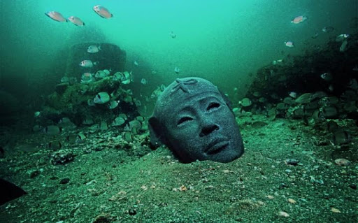
How Thonis-Heracleion resurfaced after 1,000 years underwater
The Egyptian city of Thonis-Heracleion was the main port of entry to the Mediterranean Sea between the eighth century BCE and the fourth century BCE. By the eighth century CE, what remained of the city sank into the sea and eventually became a distant memory. Without any trace, except for a few references in historical writings, the forgotten ruins rested undisturbed until the 21st century.
In 2000, the European Institute of Maritime Archaeology, led by renowned archaeologist Franck Goddio, finally discovered the city’s treasures in the depths of the Abu Qir Bay.
For thirteen years, Goddio and his team methodically excavated and explored the sunken city. They also found more than 64 shipwrecks and 700 anchors in the Abu Qir Bay.
This red granite statue of a pharaoh is over 5 meters and 5.5 tons.
The high number of maritime relics led researchers to believe that Heracleion was a mandatory port of entry for trade between the Nile and the Mediterranean.
This is also supported by the discovery of weights from Athens, which would have been used to make important measurements of goods. Never before had such weights been found among archaeological sites in Egypt.
History of Thonis-Heracleion
For more than four centuries until the foundation of Alexandria in 331 BCE, Thonis reigned supreme over the Canopic portion of the Nile River. The Greek historian Diodorus of Sicily wrote about Thonis-Heracleion in his great work, Bibliotheca Historica, between 60 BCE – 30 BCE.
Sometime in the fifth century BCE, Herodotus wrote that the Greek god and hero, Heracles, actually first stepped foot onto Egypt at this port city. Thus, the Greeks gave Thonis the name Heracleion and built a grand temple dedicated to him. Herodotus also said Paris and Helen of Troy visited the port city.
Head of the statue of Ptolemaic queen presumed to be Cleopatra II or III. 3rd century.
Religious Center of Worship
There are commonalities in the accounts of the old historians. Most significant of these is that the city boasted a huge temple constructed to honor the heroic god Heracles, hence the name, Heracleion.
The city was both a bustling trade port and a religious center of worship. Sixteen-foot stone sculptures and sarcophagi believed to contain mummified animals were discovered. This reinforces the idea that this divine city was a prominent religious site. Additionally, the annual Mysteries of Osiris celebration took place at the temple. The three large statues pictured below are a pharaoh, his queen, and the god Hapy, from left to right. They stood at the entrance to the temple.
The Egyptians had their own version of Heracles and, so, shared this godlike hero. Herodotus identifies Heracles with the Egyptian god Shu. Still, others claim Sesotris was the forerunner of the Greek hero. In all cases, this mythical god-hero signified strength.
It seems to reflect the belief by both the Egyptians and the Greeks that they were strong, proud people, as unconquerable as the mighty Hercules himself. What better way to signify Heracleion’s strength than to essentially deem it the seat of a god? And so it was that their beloved Heracles became the focal point of the thriving port city and center of trade.
Port Business
In addition to serving as a place of worship, many official business transactions took place here. Ships from various parts of the ancient world dropped their anchors and unloaded their merchandise before returning home with a fresh supply of Egyptian goods to take back with them. Officials collected taxes and fees, and a huge amount of value traded hands. The Nile was also easily defensible from this location.
Goddio with stele, 1.9 meters high, commissioned by Nectanebo (378-362BC)
The Demise of the Temple City
Thonis-Heracleion suffered from a flaw that undermined its overall strength. The Egyptians built the city upon a portion of the Nile delta. The region was particularly susceptible to subsidence, flooding, a rising sea level, and earthquakes that had the ability to trigger enormous tidal waves. As a result, these natural circumstances waged a centuries-long battle with the port.
Beginning in the second century BCE, the splendid city started sinking into the depths of the sea. Some have theorized that flooding and the excessive weight of the city contributed to its sinking.
The structures and religious statuary of which the Egyptians were so proud literally equaled millions upon millions of pounds. Additionally, the land under which those structures resided was in a perpetual state of flux due to the flooding common in the delta.
End of a City and Its Symbolism
As civilization evolved and the first millennium of the Common Era came and went, humanity approached the dawn of the Age of Reason when science and monotheism countered the age of gods and mythical heroes. It seems the sinking of this ancient Egyptian port and temple serves as a perfect metaphor for the sunset of mankind’s devotion to its old gods and reverence for ancient mythology.
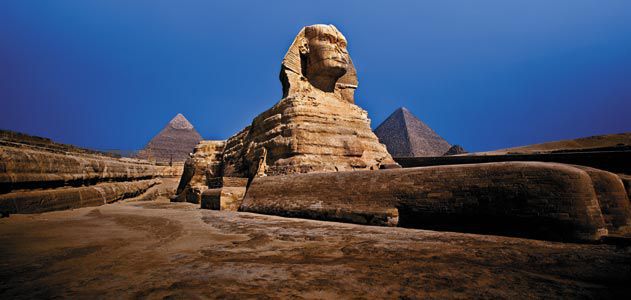
The second sphinx buried in sand in Egypt Giza plateau, pyramid much older than believed, researchers
It is one of the most prominent structures in the world and for decades has been the Sphinx – the legendary and giant statue of what seems to be a lion with a human face. It has captured the imaginations of archaeologists, photographers, and visitors on the Giza plateau of Egypt.
But there could be a second Sphinx built around the same time as the one known to the world — but this Sphinx has been hidden for thousands of years in the sands of Giza.
Two British historians, Gerry Cannon and Malcolm Hutton are now suggesting this theory: Who says that unlike numerous examples of smaller Sphinx structures and illustrated depictions of Sphinxes found in Egypt, the Sphinx of Giza is a rarity in that it stands alone, according to a report by the Egypt Today online site.
Every other Sphinx dating from ancient Egypt has been part of a pair, believed to represent the “duality” of male and female, the report says — also representing the duality of the sun and moon.
Ancient Egyptians believed that at the end of every day the sun traveled underground and reemerged as the moon, with a Sphinx protecting each end of the journey.
“Every time we have to deal with the solar cult, we should discuss of one lion and one lioness facing each other, posing parallel to each other or sitting in a back-to-back position,” said Egyptologist Bassam el-Shammaa, whose 2011 ebook, Quest for the Truth: Discovering The Second Sphinx forms the basis for the current Cannon and Hutton theory.
Cannon and Hutton also say that the Sphinx is much older than the current estimated age of approximately 4,600 years.
In fact, rather than the generally accepted belief that the Sphinx was constructed sometime between 2,700 B.C. and 2,500 B.C., though the exact date has not been pinpointed, Cannon and Hutton say that the structure could not have been built at that time.
In fact, they place the construction of the Sphinx prior to Earth’s most recent Ice Age — sometime earlier than 10,000 B.C. If their theory is correct, the Sphinx would be about eight millennia older than experts currently believe.
“The Sphinx had to have been carved when there was no sand there. You can’t carve a rock when it’s under the sand,” Cannon told the British Express newspaper. “When it was not under the sand was about 12,000 years ago and the Egyptians weren’t there.”
The researchers also say that the pyramids of Giza, which the Sphinx is apparently positioned to guard, would have been built at approximately the same time as the Sphinx — meaning that the ancient Egyptian civilization recorded by history was not the origin of the remarkable structures.
An earlier, prehistoric civilization that was perhaps wiped out by the ice age, must have built the Sphinx and pyramids, the pair of authors say.
Giant Egyptian Pyramids Hidden Beneath, buried by sands of time
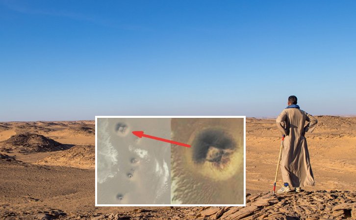
Indiana Jones found success with little more than a bullwhip and a fedora. These days, however, if you want to make your mark as an archaeologist, a bit of space technology works wonders.
Satellites have helped locate 17 pyramids and 3,000 ancient settlements hidden underground in Egypt. More than 1,000 burial sites were also discovered thanks to infra-red technology capable of probing beneath the desert sands from 450 miles above the Earth.
Astounded researchers on the ground have already confirmed that two of the pyramids exist – and they believe there are thousands more unknown sites in the region.
satellite images revealed strange structures
NASA-funded archaeologist Sarah Parcak said: ‘I couldn’t believe we could locate so many sites. To excavate a pyramid is the dream of every archaeologist.’ The finds are hugely significant. Until the latest discoveries there were thought to have been almost 140 pyramids across Egypt.
But experts have long argued that there must be many more that remain undiscovered, buried by the sands of time. Dr Parcak, from the University of Alabama at Birmingham, analysed images from satellites equipped with cameras so powerful they can zoom in on objects less than three feet in diameter on the Earth’s surface.
Huge pyramids could be buried beneath the sand.
Dr. Parcak told the BBC: ‘I could see the data as it was emerging, but for me, the “a-ha” moment was when I could step back and look at everything that we’d found.’
The mud bricks used by ancient Egyptians are much denser than the sand and soil that surrounds them, allowing the shapes of homes, temples, tombs and other structures built thousands of years ago to be seen by satellites orbiting 435miles above Earth to photograph the outlines of structures invisible to the human eye.
The cameras on the satellites are so powerful that they can precisely image objects on Earth that are less than one metre in diameter. The researchers’ findings are a major boost to the relatively new science of space archaeology.
Their most promising excavations are taking place in Tanis, the hiding place of the Ark of the Covenant in the 1981 Indiana Jones blockbuster Raiders of the Lost Ark, where they are uncovering a 3,000-year-old house.
Excitingly, the outline of the house exactly matches the shape seen on the satellite images.
Two pyramids at Saqqara – the burial ground for the ancient capital of Memphis – have already been confirmed by excavations and the site is being hailed as one of the most important in Egyptian archaeology. The oldest pyramids ever discovered were built in Saqqara around 2,600BC.
Archaeologist Dr Sarah Parcak points out the site of a buried pyramid on a satellite image
The camera’s high level of accuracy has impressed the Egyptian government, which now plans to use the technology to identify and protect its colossal heritage in the future.
Dr Parcak believes that there are many more buildings buried deeper than those already spotted, the most likely location being under the banks of the River Nile.
She said: ‘These are just the sites close to the surface. There are many thousands of additional sites that the Nile has covered over with silt.
‘This is just the beginning of this kind of work.’
She told the BBC: ‘It just shows us how easy it is to underestimate both the size and scale of past human settlements.
‘These are just the sites [close to] the surface. There are many thousands of additional sites that the Nile has covered over with silt. This is just the beginning of this kind of work.’
She said the technology could be used to monitor the looting of antiquities, as well as to engage young people around the world in science and help archaeologists in their quest to uncover the secrets of the past.
The archaeologist said, ‘We have to think bigger and that’s what the satellites allow us to do. Indiana Jones is old school. We’ve moved on from Indy, sorry Harrison Ford.’
Nabta Playa: The World’s First Astronomical Site Was Built in Africa and Is Older Than Stonehenge
Nabta Playa has been assessed by an inventory of Egyptian archeological sites in accordance with the UNESCO World Heritage Convention as having “theory solar and stellar alignments.”
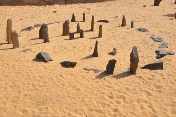
This stone circle of 7,000 years has tracked the summer solstice and the arrival of the annual monsoon season. It’s the oldest known astronomical site on Earth
Ancient civilizations around the world constructed huge stone circles for thousands of years, aligning them with the sun and stars to identify the seasons. These early calendars foretold the coming of spring, summer, fall, and winter, helping civilizations track when to plant and harvest crops.
They also served as ceremonial sites, both for celebration and sacrifice.
These megaliths — large, prehistoric monuments made of stone — may seem mysterious in our modern era, when many people lack a connection with, or even view of, the stars.
Some even hold them up as supernatural or divined by aliens. But many ancient societies kept time by tracking which constellations rose at sunset, like reading a giant, celestial clock.
And others pinpointed the sun’s location in the sky on the summer and winter solstice, the longest and shortest days of the year, or the spring and fall equinox.
Europe alone holds some 35,000 megaliths, including many astronomically-aligned stone circles, as well as tombs (or cromlechs) and other standing stones. These structures were mostly built between 6,500 and 4,500 years ago, largely along the Atlantic and Mediterranean coasts.
The most famous of these sites is Stonehenge, a monument in England that’s thought to be around 5,000 years old. Though still old, at that age, Stonehenge may have been one of the youngest such stone structures to be built in Europe.
The chronology and extreme similarities between these widespread European sites lead some researchers to think the regional tradition of constructing megaliths first emerged along the coast of France. It was then passed across the region, eventually reaching Great Britain.
But even these primitive sites are at least centuries younger than the world’s oldest known stone circle: Nabta Playa.
The stone circle of Nabta Playa marks the summer solstice, a time that coincided with the arrival of monsoon rains in the Sahara Desert thousands of years ago.
Located in Africa, Nabta Playa stands some 700 miles south of the Great Pyramid of Giza in Egypt. It was built more than 7,000 years ago, making Nabta Playa the oldest stone circle in the world — and possibly Earth’s oldest astronomical observatory.
It was constructed by a cattle worshiping cult of nomadic people to mark the summer solstice and the arrival of the monsoons.
“Here is human beings’ first attempt to make some serious connection with the heavens,” says J. McKim Malville, a professor emeritus at the University of Colorado and archaeoastronomy expert.
“This was the dawn of observational astronomy,” he adds. “What in the world did they think about it? Did they imagine these stars were gods? And what kinds of connections did they have with the stars and the stones?”
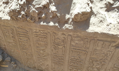
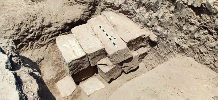
LUXOR, EGYPT—According to an Ahram Online report, several structures were uncovered during an excavation at the Avenue of Sphinxes, a ceremonial passageway lined with ram-headed sculptures that once connected temples in Luxor and Karnak.
Mudbrick kilns dating to the Roman period (30 B.C.–A.D. 640) are thought to have been used to fire pottery. A wall dated to the Egyptian Late Period (712–332 B.C.)
The Egyptian archaeological mission revealed during the works of the project to restore and revive the major historical road known as the Rams Road, a number of round ovens for burning mud-brick with burning marks, and a huge wall of mud bricks from the Roman and Late Periods.
Dr.. Mustafa Waziri, Secretary-General of the Supreme Council of Antiquities, said that these furnaces and fences were found in the Nag Abu Asbah area, and perhaps the furnaces were used in the manufacture of pottery or faience.
As for the wall, it was found west of the procession road of the Temple of Khonsu, about 30 meters high and two and a half meters wide and 3 wide Meters, and consists of 17 courses of mud bricks.
The mission also found a wall that was built from 3 sandstone blocks, which is an extension of the wall that was protecting the eastern bank of the Nile from changing levels of the Nile River during seasons of flooding and burning.
This wall extends from the front of Karnak Temple in the north to Luxor Temple in the south alongside The Great Procession Road is about 3 kilometers long.
Dr. Waziri agreed that the work team has taken all necessary measures to prevent and protect from the new Coronavirus, during the explorations, as all of the project workers are wearing masks and taking social spaces in the course of drilling.
It is worth noting that the excavation work in various areas of the Rams road has been ongoing since 2017 in order to unveil all the rams in it within the framework of the road rehabilitation project, in preparation for its opening soon.
Prehistoric explorers could have depended on shellfish for their survival in times of drought, a new study suggests, following the migratory routes from Africa.
The research examined fossil reefs in the area of the now-submerged Red Sea coastline that marked prehistoric migratory routes from Africa to Arabia.
The results show that this coast provided the resources necessary to act as a gateway out of Africa during periods of little rainfall when other food sources were scarce.
Living specimen of the marine mollusc Conomurex fasciatus. Millions of these shells were found on the Farasan Islands in Saudi Arabia as the food refuse of prehistoric fishers.
The research team, led by the University of York, focused on the remains of 15,000 shells dating back 5,000 years to an arid period in the region.
With the coastline of original migratory routes submerged by sea-level rise after the last Ice Age, the shells came from the nearby Farasan Islands in Saudi Arabia.
The researchers found that populations of marine mollusks were plentiful enough to allow continuous harvests without any major ecological impacts and their plentiful availability would have enabled people to live through times of drought.
Lead author, Dr. Niklas Hausmann, Associate Researcher at the Department of Archaeology at the University of York, said:
“The availability of food resources plays an important role in understanding the feasibility of past human migrations—hunter-gatherer migrations would have required local food sources and periods of aridity could, therefore, have restricted these movements.
“Our study suggests that Red Sea shorelines had the resources necessary to provide a passage for prehistoric people.”
The study also confirms that communities settled on the shorelines of the Red Sea could have relied on shellfish as a sustainable food resource all year round.
Dr. Hausmann added: “Our data shows that at a time when many other resources on land were scarce, people could rely on their locally available shellfish.
Previous studies have shown that people of the southern Red Sea ate shellfish year-round and over periods of thousands of years. We now also know that this resource was not depleted by them, but shellfish continued to maintain a healthy population.”
The shellfish species found in the archeological sites on the Farasan Islands were also found in abundance in fossil reefs dating to over 100 thousand years ago, indicating that these shellfish have been an available resource over longer periods than archeological sites previously suggested.
Co-author of the study, Matthew Meredith-Williams, from La Trobe University, said: “We know that modeling past climates to learn about food resources is extremely helpful, but we need to differentiate between what is happening on land and what is happening in the water. In our study, we show that marine foods were abundant and resilient and being gathered by people when they couldn’t rely on terrestrial food.”
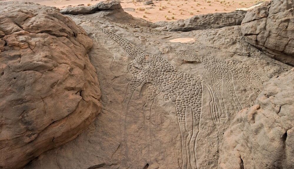
Rock art of a Giraffe dabous niger dated at Approximately 9,000 years ago
Giraffe with their long-necks and lanky gait have captivated humans for thousands of years. Rock carvings in the Sahara Desert in northern Niger, estimated to be 9,000 years old, represent the earliest recorded human association with a giraffe.
The Dabous giraffes, located north of Agadez in Niger, are some of the most striking examples of Saharan rock art known. It is not known who carved the figures, but they may have been created by the Tuareg people.
Rock engravings spanning several thousands of years are common in the Dabous area; over 300 are known, varying in size from quite small to the life-sized depictions shown here.
Probably dating to c.5000 – 3000 BC, each giraffe is engraved into a gently sloping rock face, the choice of location possibly a deliberate attempt to capture the slanting rays of the sun so that the shallow engravings were visible at certain times of the day; human figures representing local hunter-gatherers are drawn to scale below the giraffes. The naturalism, perspective, and attention to detail are striking.
Africa’s climate was much wetter during the period in which the engravings were made than it is at present, and the Saharan region was verdant grassland that supported rich wildlife.
Other examples of broadly contemporary rock art in the region depict elephants, gazelles, zebu cattle, crocodiles, and other large animals of the grasslands, although giraffes appear to have been especially important to regional hunter-gatherer groups.
Under the auspices of UNESCO, the Bradshaw Foundation was tasked with coordinating the Dabous preservation project, in association with the Trust for African Rock Art. The preservation project was to involve taking a mould of the carvings from which to create a limited edition of aluminium casts, one of which would be gifted to the town of Agadez near the archaeological site, another of which would be located at the National Geographic headquarters in Washington D.C.
A further element of the preservation project was to sink a water well in the area in order to support a small Tuareg community who would be responsible for guiding tourists at the Dabous site. In the heart of the Sahara lies the Tenere Desert. ‘Tenere’, literally translated as ‘where there is nothing’, is a barren desert landscape stretching for thousands of miles, but this literal translation belies its ancient significance – for over two millennia, the Tuareg operated the trans-Saharan caravan trade route connecting the great cities on the southern edge of the Sahara via five desert trade routes to the northern coast of Africa.
One of the finest examples of ancient rock art in the world – two life-size giraffe carved in stone
Dabous Giraffe Rock Art Petroglyph one of the finest examples of ancient rock art in the world – two life-size giraffe carved in stone and before the Tuareg? Life in the region now known as the Sahara has evolved for millennia, in varying forms.
One particular piece of evidence of this age-old occupation can be found at the pinnacle of a lonely rocky outcrop. Here, where the desert meets the slopes of the Air Mountains, lies Dabous, home to one of the finest examples of ancient rock art in the world – two life-size giraffe carved in stone.
They were first recorded as recently as 1987 by Christian Dupuy. A subsequent field trip organised by David Coulson of the Trust for African Rock Art brought the attention of archaeologist Dr Jean Clottes, who was startled by their significance, due to the size, beauty and technique.
The two giraffe, one large male in front of a smaller female, were engraved side by side on the sandstone’s weathered surface. The larger of the two is over 18 feet tall, combining several techniques including scraping, smoothing, and deep engraving of the outlines. However, signs of deterioration were clearly evident.
Despite their remoteness, the site was beginning to receive more and more attention, as these exceptional carvings were beginning to suffer the consequences of both voluntary and involuntary human degradation. The petroglyphs were being damaged by trampling, but perhaps worse than this, they were being degraded by Grafitti, and fragments were being stolen.
Cleaning the surface
The silicon sections
The obvious answer to was to preserve the giraffe carvings because of their artistic significance, but also their placement within a palaeo-African contexts Chairman of the Bradshaw Foundation, Damon de Laszlo, saw that ‘the obvious answer to this was to attempt to preserve them, not only because of their artistic significance, but also their placement within a palaeo-African context ie. a greener Sahara, and how this ties in with our ‘Journey of Mankind’ Genetic Map.’
Damon de Laszlo: The obvious answer was to preserve the giraffe carvings because of their artistic significance, but also their placement within a palaeo-African context
This preservation would take the form of making a mould of the carvings and then cast them in a resistant material. The point of this was two-fold; now was the time to take the mould because the carvings were still – just – in a perfect condition, and by publicising the importance of the carvings, their value would be realized and their protection prioritized.
By chance, a year earlier saw the publication of ‘Zarafa’ by Michael Allin, depicting the fascinating tale of a giraffe from Sudan being led across France in 1826 – the Dabous giraffe would travel to France nearly two hundred years later but in a slightly different fashion.
One of the major aims of the Bradshaw Foundation is to preserve ancient rock art, but with a project of this nature and scale, we obviously needed permission from both UNESCO and the government of Niger.
Moreover, it was important to ensure that the project would be carried out at the grass-roots level, with full involvement of the Tuareg custodians. Finally, consideration of the future preservation had to be catered for, and for this reason, a well was sunk near the site to provide water for a small group to live in the area, a member of which would act as a permanent guide – to show where to mount the outcrop, where to best view the petroglyphs without walking on them, and to ensure no damage or theft.