Category Archives: CANADA

460-Year-Old Hunting Bow Discovered Underwater in Alaska’s Lake Clark National Park

460-Year-Old Hunting Bow Discovered Underwater in Alaska’s Lake Clark National Park

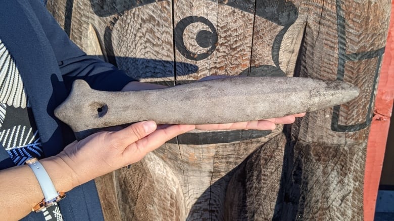
National Park Service employees made an unlikely discovery in the backcountry of Lake Clark National Park and Preserve in Alaska this past September: a 54-inch wooden hunting bow that was found under 2 feet of water, but still intact.

460-Year-Old Hunting Bow Discovered Underwater in Alaska’s Lake Clark National Park
NPS archaeologist Jason Rogers and Alaska State archaeologist Rich VanderHoek carefully inspect the bow.

Scientists and archaeologists are analyzing the hunting bow in an attempt to learn more about its origin and history. According to radiocarbon dating conducted by the NPS, the bow is estimated to be 460 years old, ranging in origin between 1506 and 1660. The real mystery lies not in how old the bow is, but where it came from.

Park officials found the antique weapon on Dena’ina lands, an Athabascan indigenous people whose ancestral lands cover much of South-Central Alaska, including a large portion of Lake Clark National Park and Preserve.

However, preliminary research suggests that the handcrafted bow might not be of Dena’ina origin. After consulting with Elders and comparing the bow with similar artefacts from that time period, experts believe the artefact has more in common with a Yup’ik or Alutiq style bow.

Lake Clark National Park and Preserve are located on Dena’ina lands in south-central Alaska.

The homeland of the Dena’ina, which comprises roughly 41,000 square miles along the coast of the Cook Inlet, is called the Denaʼina Ełnena, and it includes lands where present-day Anchorage is located. Dena’ina lands also cover much of Lake Clark National Park and Preserve, including the lake itself, which is traditionally known as “Qizhjeh Vena”. 

The Dena’ina culture, which prioritizes a connection to nature and respect for the wilderness, has a rich history in the Athabascan region.

“We call this ‘K’etniyi’ meaning ‘it’s saying something,” writes Karen Evanhoff, a cultural anthropologist for Lake Clark National Park and Preserve.

Anthropologists have also learned that the Dena’ina regularly interacted with indigenous peoples from neighbouring regions, including the Yup’ik who live in the coastal region of southwestern Alaska, from Bristol Bay along the Bering coast and up to Norton Sound.

This intercultural history would help explain how a Yup’ik bow might end up on Dena’ina homelands in the first place.     

“For the Dena’ina people, trading and sharing knowledge with their Yup’ik neighbours as well as other groups such as the Tanana, Tlingit, Ahtna, Deg Hit’an and coastal residents of Prince William Sound and Kodiak was common,” the NPS explains. 

Experts are still working to piece together the clues, however, and the cultural history of the bow is just one part of the puzzle. 

Dr. Priscilla Morris takes a closer look at the bow with a hand lens.

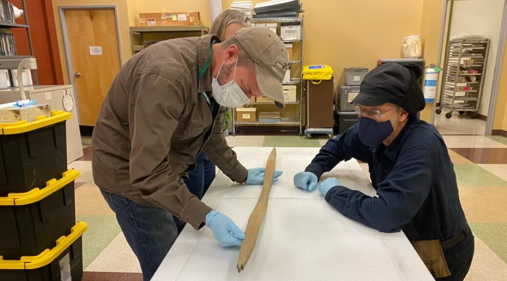
Soon after it was discovered, the bow was transported to the Park Service’s Regional Curatorial Center in Anchorage, where experts have inspected the artefact and analyzed its natural origins. As part of this analysis, the NPS brought in Dr. Priscilla Morris, a wood identification consultant with the U.S. Forest Service.

“After inspecting the artefact, I am leaning towards spruce,” Morris told the NPS after taking a closer look at the bow. “Birch is also a suspected species, but I did not see any anatomical characteristics that lead me to believe birch over spruce.”

Morris explained that her hypothesis was based solely on what she could see underneath a hand lens and that a concrete identification would require looking at a cut-up sample underneath a microscope.

This is unlikely to happen anytime soon, however, as the NPS wants to preserve the bow and keep it intact for the time being. As NPS archaeologist Jason Rogers explained, these discoveries are rare in Alaska, especially when compared to Europe and other more developed parts of the world. 

“In Alaska, we just don’t have that kind of development so it’s very rare,” Rogers told the local news earlier this week. “It’s very rare for us to come across material like this.”

Carved stone pillar found on B.C. beach identified as an Indigenous artefact

Carved stone pillar found on B.C. beach identified as an Indigenous artifact

A carved stone pillar found at low tide on a beach in Victoria last summer is an Indigenous cultural treasure, the Royal B.C. Museum has confirmed.

Carved stone pillar found on B.C. beach identified as an Indigenous artifact
The stone could be the same one mentioned by Lekwungen elders to German-American anthropologist Franz Boas in the late 1800s.

The museum is working with the Songhees and Esquimalt First Nations to determine the most suitable home for the pillar carved with the features of a face, Songhees Chief Ron Sam said in an interview on Wednesday.

Over the years, many artefacts have been unearthed in the area, he said, but nothing has matched the 100-kilogram stone pillar.

“I can’t wait to find out more information from our elders,” said Sam, noting interactions with elders are limited now because of the COVID-19 pandemic.

He said Songhees and Esquimalt elders will guide the decision-making around whether and how the stone pillar may be displayed publicly.

A local resident, Bernhard Spalteholz, received a tip about the carved stone found along the beach below Victoria’s Beacon Hill Park last July and shared photos with the museum, said the museum’s archaeology curator Grant Keddie.

“I right away realized, my gosh, this is exciting,” Keddie said of the find.

Spalteholz did the right thing by contacting the museum to ensure it would be properly cared for, said both Keddie and Sam.

A local resident, Bernhard Spalteholz, received a tip about the carved stone found along the beach below Victoria’s Beacon Hill Park last July and shared photos with the museum, said the museum’s archaeology curator Grant Keddie.

Pillar may have stood at the edge of a cliff

Conservationists worked to protect the integrity of the stone, which was covered in algae after being submerged in seawater, said Keddie.

He speculates the pillar once stood near the edge of a cliff above the beach where it was found until parts of the cliff came down in a landslide.

“I think possibly some storm had turned [the stone] up,” he said. “It may have been buried further out to sea covered with seaweed and maybe only in recent years was shifted up onto this beach and then exposed.”

Radiocarbon dating is effective only on organic items such as bone and wood, but written and oral histories can provide insight into the stone’s significance, said Keddie.

It’s very likely a special stone that was used in rituals and ceremonies, he said, explaining that Coast Salish peoples had “weather specialists.”

They were believed to have “special powers to draw the salmon in when they were late, or you could undertake rituals [with] certain stones to change the weather to make it good for fishing, to make it worse for your enemies,” he said.

The stone could be the same one mentioned by Lekwungen elders to German-American anthropologist Franz Boas in the late 1800s, said Keddie.

“Indigenous elders told this very brief little one-liner about these stone figures down near Finlayson Point, right where this thing was found.”

The location of the discovery matches Boas’ description of that figure as being “not far” from the military gun batteries once found nearby, he said.

“I always wonder, are there more of them out there?” Keddie added.

Ancient Coast Salish war club discovered in Vancouver Island man’s backyard

Ancient Coast Salish war club discovered in Vancouver Island man’s backyard

Mark Lake found a little piece of history in his backyard while cleaning up after a storm last April.

Ancient Coast Salish war club discovered in Vancouver Island man's backyard
Mark Lake found the Indigenous artefact on his property while cleaning up after a storm, and brought it to the K’omoks First Nation.

Lake, of Gartley Point near the seaside village of Royston in Vancouver Island, came across an interesting piece of wood sticking out from under his maple tree — which turned out to be an ancient Coast Salish war club.

After friends saw pictures of it, they directed Lake to the K’omoks First Nation.

Chief Nicole Rempel of the K’omoks First Nation says it was pretty exciting.

“I’ve worked with various people repatriating artefacts since 2013 for our nation and I hadn’t seen a piece like this, completely intact,” she said.

From left, Mark Lake, Chief Nicole Rempel and Mark’s wife Katie Lake. Rempel says the K’omoks First Nation is working with an archaeologist to learn more about the club, which she’s holding in this photo.

Rempel says the club is quite significant to the nation’s culture and that it’s always exciting when something can be returned to its “rightful place.”

“It helps us understand more about our ancestors in the way that we live, the tools that we created,” she said.

Mark and Katie Lake with Chief Nicole Rempel (right). Rempel says the artefact will help the K’omoks First Nation better understand its ancestors and history.

“It truly must have been a labour of love to have made something so intricate, and with so little tools, back in those times, so it really gives us a bit more information about who we were, who our ancestors were in the past,” she said.

Lake says he’s just as excited about returning the artefact and learning more about it from the nation.

“They’ve been very open with exchanging any information they have gleaned on it as to its history and where it may have come from and so that’s reward enough for us and we really enjoyed being part of the process,” he said on CBC’s All Points West.

Rempel says they are working with an archaeologist to determine more about the artefact.

“We can do some geotechnical testing on the club, or geochemistry, which would figure out what kind of stone it was made of and what region it came from or whether it was traded,” she said.

Rempel says what Lake did was commendable, as many people who find things like this don’t always bring them forward.

“I just really encourage everyone that finds an artefact or ancestral remains for that matter to reach out to the local Indigenous communities because it’s really just building our database of knowledge and identifying who we are and who we were,” she said.

Armored Dinosaur’s Last Meal Found Preserved in Its Fossilized Belly

Armored Dinosaur’s Last Meal Found Preserved in Its Fossilized Belly

More than 110 million years ago, a lumbering 1,300-kilogram, armour-plated dinosaur ate its last meal, died, and was washed out to sea in what is now northern Alberta. This ancient beast then sank onto its thorny back, churning up mud in the seabed that entombed it — until its fossilized body was discovered in a mine near Fort McMurray in 2011.

Armored Dinosaur’s Last Meal Found Preserved in Its Fossilized Belly
The Borealopelta fossil is on display at the Royal Tyrell Museum in Alberta, Canada.

Since then, researchers at the Royal Tyrrell Museum of Palaeontology in Drumheller, Alta., Brandon University, and the University of Saskatchewan (USask) have been working to unlock the extremely well-preserved nodosaur’s many secrets — including what this large armoured dinosaur (a type of ankylosaur) actually ate for its last meal.

“The finding of the actual preserved stomach contents from a dinosaur is extraordinarily rare, and this stomach recovered from the mummified nodosaur by the museum team is by far the best-preserved dinosaur stomach ever found to date,” said USask geologist Jim Basinger, a member of the team that analyzed the dinosaur’s stomach contents, a distinct mass about the size of a soccer ball.

“When people see this stunning fossil and are told that we know what its last meal was because its stomach was so well preserved inside the skeleton, it will almost bring the beast back to life for them, providing a glimpse of how the animal actually carried out its daily activities, where it lived, and what its preferred food was.”

There has been lots of speculation about what dinosaurs ate, but very little is known. In a just-published article in Royal Society Open Science, the team led by Royal Tyrrell Museum palaeontologist Caleb Brown and Brandon University biologist David Greenwood provides detailed and definitive evidence of the diet of large, plant-eating dinosaurs — something that has not been known conclusively for any herbivorous dinosaur until now.

“This new study changes what we know about the diet of large herbivorous dinosaurs,” said Brown. “Our findings are also remarkable for what they can tell us about the animal’s interaction with its environment, details we don’t usually get just from the dinosaur skeleton.”

Previous studies had shown evidence of seeds and twigs in the gut but these studies offered no information as to the kinds of plants that had been eaten. While tooth and jaw shape, plant availability and digestibility have fuelled considerable speculation, the specific plant’s herbivorous dinosaurs consumed has been largely a mystery.

So what was the last meal of Borealopelta markmitchelli (which means “northern shield” and recognizes Mark Mitchell, the museum technician who spent more than five years carefully exposing the skin and bones of the dinosaur from the fossilized marine rock)?

An illustration of Borealopelta chowing down on some ferns.

“The last meal of our dinosaur was mostly fern leaves — 88 per cent chewed leaf material and seven per cent stems and twigs,” said Greenwood, who is also a USask adjunct professor.

“When we examined thin sections of the stomach contents under a microscope, we were shocked to see beautifully preserved and concentrated plant material. In marine rocks, we almost never see such superb preservation of leaves, including the microscopic, spore-producing sporangia of ferns.”

Team members Basinger, Greenwood and Brandon University graduate student Jessica Kalyniuk compared the stomach contents with food plants known to be available from the study of fossil leaves from the same period in the region. They found that the dinosaur was a picky eater, choosing to eat particular ferns (leptosporangiate, the largest group of ferns today) over others, and not eating many cycad and conifer leaves common to the Early Cretaceous landscape.

Specifically, the team identified 48 palynomorphs (microfossils like pollen and spores) including moss or liverwort, 26 clubmosses and ferns, 13 gymnosperms (mostly conifers), and two angiosperms (flowering plants).

“Also, there is considerable charcoal in the stomach from burnt plant fragments, indicating that the animal was browsing in a recently burned area and was taking advantage of a recent fire and the flush of ferns that frequently emerges on a burned landscape,” said Greenwood.

“This adaptation to a fire ecology is new information. Like large herbivores alive today such as moose and deer, and elephants in Africa, these nodosaurs by their feeding would have shaped the vegetation on the landscape, possibly maintaining more open areas by their grazing.”

The team also found gastroliths, or gizzard stones, generally swallowed by animals such as herbivorous dinosaurs and today’s birds such as geese to aid digestion.

“We also know that based on how well-preserved both the plant fragments and animal itself are, the animal’s death and burial must have followed shortly after the last meal,” said Brown. “Plants give us a much better idea of the season than animals, and they indicate that the last meal and the animal’s death and burial all happened in the late spring to mid-summer.”

“Taken together, these findings enable us to make inferences about the ecology of the animal, including how selective it was in choosing which plants to eat and how it may have exploited forest fire regrowth. It will also assist in the understanding dinosaur digestion and physiology.”

Borealopelta markmitchelli, discovered during mining operations at the Suncor Millennium open-pit mine north of Fort McMurray, has been on display at the Royal Tyrrell Museum since 2017. The main chunk of the stomach mass is on display with the skeleton. Other members of the team include museum scientists Donald Henderson and Dennis Braman, Brandon University research associate and USask alumna Cathy Greenwood.

Research continues on Borealopelta markmitchelli — the best fossil of a nodosaur ever found — to learn more about its environment and behaviour while it was alive. Student Kalyniuk is currently expanding her work on fossil plants of this age to better understand the composition of the forests in which they lived. Many of the fossils she will examine are in Basinger’ collections at USask.

The research was funded by Canada Foundation for Innovation, Research Manitoba, Natural Sciences and Engineering Research Council of Canada, National Geographic Society, Royal Tyrrell Museum Cooperating Society, and Suncor Canada, as well as in-kind support from Olympus Canada.

Mammoths Survived in Canada Until 5,000 Years Ago

Mammoths Survived in Canada Until 5,000 Years Ago

Ancient 30,000-year-old DNA of past environments found in permafrost from Yukon, Canada reveals woolly mammoths roamed the region as recently as 5,000 years ago.

The discovery was made by scientists at McMaster University, who built on its previous research that speculated the massive animals died out 9,700 years earlier during the mid-Holocene epoch – a time of climate instability.

The soil samples were taken from the Klondike region of Canada’s Yukon in the early 2010s, but have were placed in a freezer and forgotten.

Mammoths Survived in Canada Until 5,000 Years Ago
Researchers used DNA capture-enrichment technology developed at McMaster University to isolate and rebuild the fluctuating animal and plant communities during the Pleistocene-Holocene transition.

Tyler Murchie, an archaeologist specializing in ancient DNA at the university, told Gizmodo that when he saw the samples, he thought there may be ‘cool stuff’ inside them ‘waiting for someone to study.’

Murchie and his team isolated and rebuilt the DNA, showing the fluctuating animal and plant communities at different time points during the Pleistocene-Holocene transition, which was an unstable climatic period 11,000 to14,000 years ago when several large species such as mammoths, mastodons and sabre-toothed cats disappeared.

The analysis also showed that mammoths and Yukon horses, which lived alongside mammoths, were already disappearing from the Earth before the climate instability.

However, the researchers note that they did not go extinct due to humans overhunting them as previously thought.

The evidence shows that both the woolly mammoth and ancient horse persisted until as recently as 5,000 years ago, bringing them into the mid-Holocene, the interval beginning roughly 11,000 years ago that we live in today.

The soil samples were taken from the Klondike region of Canada’s Yukon in the early 2010s, but have were placed in a freezer and forgotten

During the early Holocene, the environment in Yukon was dramatically changed due to a shifting climate.  It was previously flowing with lush grasslands, known as the ‘Mammoth Steppe’, but became overrun with shrubs and mosses that were not seen as food for large grazing herds of mammoths, horses and bison. 

Grasslands cannot survive in that part of North America and experts say that is because there are no longer the large grazing animals to manage them.

‘The rich data provides a unique window into the population dynamics of megafuana and nuances the discussion around their extinction through more subtle reconstructions of past ecosystems’ evolutionary geneticist Hendrik Poinar, a lead author on the paper and director of the McMaster Ancient DNA Centre, said in a statement. 

McMaster scientists were able to better date the extinction of the ancient animals with the help of new technology that was not available when they proposed the creatures were living in the Yukon 9,700 years ago. 

‘Now that we have these technologies, we realize how much life-history information is stored in permafrost,’ said Murchie.

Murchie and his team isolated and rebuilt the DNA, showing the fluctuating animal and plant communities at different time points during the Pleistocene-Holocene transition, which was an unstable climatic period 11,000 to14,000 years ago when a several large species such as mammoths, mastodons and sabre-toothed cats disappeared

‘The amount of genetic data in permafrost is quite enormous and really allows for a scale of the ecosystem and evolutionary reconstruction that is unparalleled with other methods to date’ he says.

‘Although mammoths are gone forever, horses are not’ says Ross MacPhee of the American Museum of Natural History, another co-author. 

‘The horse that lived in the Yukon 5,000 years ago is directly related to the horse species we have today, Equus caballus. 

‘Biologically, this makes the horse a native North American mammal, and it should be treated as such.’

Goodbye, Columbus: Vikings crossed the Atlantic 1,000 years ago

Goodbye, Columbus: Vikings crossed the Atlantic 1,000 years ago

Long before Columbus crossed the Atlantic, eight timber-framed buildings covered in sod stood on a terrace above a peat bog and stream at the northern tip of Canada’s island of Newfoundland, evidence that the Vikings had reached the New World first.

Goodbye, Columbus: Vikings crossed the Atlantic 1,000 years ago
A tourist (R) photographs the Viking replica ship the Islendingur as it arrives in the fishing village of L’Anse aux Meadows in Newfoundland.

But precisely when the Vikings journeyed to establish the L’Anse aux Meadows settlement had remained unclear – until now.

Scientists on Wednesday said a new type of dating technique using a long-ago solar storm as a reference point revealed that the settlement was occupied in 1021 AD, exactly a millennium ago and 471 years before the first voyage of Columbus. The technique was used on three pieces of wood cut for the settlement, all pointing to the same year.

A wood fragment from the Norse layers at the L’Anse aux Meadows Viking settlement established 1,000 years ago near Hay Cove, Newfoundland, Canada is seen in an undated microscopic image.

The Viking voyage represents multiple milestones for humankind. The settlement offers the earliest-known evidence of a transatlantic crossing. It also marks the place where the globe was finally encircled by humans, who thousands of years earlier had trekked into North America over a land bridge that once connected Siberia to Alaska.

“Much kudos should go to these northern Europeans for being the first human society to traverse the Atlantic,” said geoscientist Michael Dee of the University of Groningen in the Netherlands, who led the study published in the journal Nature.

The Vikings, or Norse people, were seafarers with Scandinavian homelands: Norway, Sweden and Denmark. They ventured through Europe, sometimes colonizing and other times trading or raiding. They possessed extraordinary boat-building and navigation skills and established settlements in Iceland and Greenland.

“I think it is fair to describe the trip as both a voyage of discovery and a search for new sources of raw materials,” Dee said. “Many archaeologists believe the principal motivation for them seeking out these new territories was to uncover new sources of timber, in particular.

It is generally believed they left from Greenland, where wood suitable for construction is extremely rare.” Their wooden vessels, called longboats, were propelled by sail and oars. One surviving example, called the Oseberg ship, is roughly 70 feet (21.6 meters long).

The Viking Age is traditionally defined as 793-1066 AD, presenting a wide range for the timing of the transatlantic crossing.

Ordinary radiocarbon dating – determining the age of organic materials by measuring their content of a particular radioactive isotope of carbon – proved too imprecise to date L’Anse aux Meadows, which was discovered in 1960, although there was a general belief it was the 11th century.

The new dating method relies on the fact that solar storms produce a distinctive radiocarbon signal in a tree’s annual growth rings. It was known there was a significant solar storm – a burst of high-energy cosmic rays from the sun – in 992 AD.

In all three pieces of wood examined, from three different trees, 29 growth rings were formed after the one that bore evidence of the solar storm, meaning the wood was cut in 1021, said University of Groningen archaeologist Margot Kuitems, the study’s first author.

It was not local indigenous people who cut the wood because there is evidence of metal blades, which they did not possess, Dee said.

The length of the occupation remains unclear, though it may have been a decade or less, and perhaps 100 Norse people were present at any given time, Dee said. Their structures resembled Norse buildings on Greenland and Iceland.

Oral histories called the Icelandic Sagas to depict a Viking presence in the Americas. Written down centuries later, they describe a leader named Leif Erikson and a settlement called Vinland, as well as violent and peaceful interactions with the local peoples, including capturing slaves.

The 1021 date roughly corresponds to the saga accounts, Dee said, adding: “Thus it begs the question, how much of the rest of the saga adventures are true?”

While feeding bison, a man discovers a rare 1,000-year-old rock carving by accident

While feeding bison, a man discovers a rare 1,000-year-old rock carving by accident

An archaeologist has discovered rock carvings dating back over 1,000 years at Wanuskewin Heritage Park, Saskatchewan, Canada. What makes the discovery even more remarkable is that it happened completely by accident.

Wanuskewin’s chief archaeologist, Ernie Walker, made the discovery in the summer of 2020 while out feeding bison in a paddock located 800 meters west of the Wanuskewin building, it was announced on Friday.

As they were rolling around in the dirt wallowing, the bison had cleared a patch of ground where Walker spotted a boulder peeking through the dirt. Further inspecting the rock, the archaeologist noticed grooves that formed a definite pattern. Walker was able to determine that the boulder was actually a petroglyph.

Walker says that the boulder is a “Ribstone” resembling the bones of a bison and representing fertility, carved over a thousand years ago. He goes on to explain that he had searched the area previously but had missed the petroglyph.

Following this discovery, as the Ribstone was being excavated, Walker and his team turned up three more petroglyphs, as well as the tool that they believe was used to make the carvings.

“This is tremendously significant and very unusual,” Walker says. “Whoever did that, left it there or misplaced it, probably over a thousand years ago. I like to think it’s their business card. They left their business card here.”

The Wanuskewin Heritage Park team estimates that the petroglyphs date back anywhere between 300 and 1,800 years, when placed into the context of historic events this gives a probable age of 1,000 years old.

“It is extremely rare to find four carved boulders together, and even more rare to locate the carving tool used to make them.

A truly remarkable story, however, is the bison,” the team said in a press release. “Had they not been reintroduced to their traditional land— after being hunted nearly to extinction in the 1870s—this important scientific discovery would have remained hidden.”

Bison were reintroduced to Wanuskewin Heritage Park after an absence of over 150 years in 2019.

READ ALSO: ‘HELLBOY’ HORNED DINOSAUR SPECIES DISCOVERED IN CANADA

The reintroduction of the animal was part of a $40-million revitalization that included conservation efforts to repopulate bison numbers across North America.

While feeding bison, a man discovers a rare 1,000-year-old rock carving by accident
A 1,000-year-old petroglyph was found in Wanuskewin.

“The discovery of these petroglyphs is a testament to just how sacred and important this land is,” CEO of Wanuskewin Heritage Park, Darlene Brander, said.

“The individual who made these petroglyphs was actually carving their legacy into the rock many years ago.”

The Wanuskewin Heritage Park, located on Opimihaw Creek, a tributary of the South Saskatchewan River, is currently applying for the status as a United Nations Educational Scientific and Cultural Organization Heritage site. Brander believes that this could be the deciding factor in that application.

Ernie Walker found the petroglyphs in the summer of 2020.

An archaeological dig in Newfoundland unearths what could be Canada’s oldest English coin

Archeological dig in Newfoundland unearths what could be Canada’s oldest English coin

Archaeologists in Newfoundland have unearthed what may be the oldest English coin ever found in Canada—and perhaps North America. Working at the site of a former English colony, the team dug up a rare two-penny piece that was minted more than 520 years ago, between 1493 and 1499, reports Chris O’Neill-Yates for CBC News.

Minted in Canterbury between 1493 and 1499, the silver half groat dates to the middle of Henry VII’s reign, when a rebellion led by pretender Perkin Warbeck threatened to unseat the nascent Tudor dynasty.

Known as a half groat, the coin dates to the reign of England’s first Tudor king, Henry VII, who ruled from 1485 to 1509. It was uncovered at Cupids Cove Plantation Provincial Historic Site, where English merchant John Guy established a colony in 1610.

Researchers found the object near what would have been a bastion in the fortified settlement.

“Some artefacts are important for what they tell us about a site, while others are important because they spark the imagination,” says archaeologist William Gilbert, who discovered the site in 1995 and continues to lead excavations there today, in a statement.

“This coin is definitely one of the latter. One can’t help but wonder at the journey it made, and how many hands it must have passed through from the time it was minted … until it was lost in Cupids sometime early in the 17th century.”

A better-preserved example of a Henry VII half-groat.

Gilbert showed the newly unearthed, nickel-sized coin to Paul Berry, a former curator at the Bank of Canada Museum who helped authenticate the piece reports the Canadian Press.

The silver coin was minted in Canterbury around the middle of Henry’s reign when a rebellion led by pretender Perkin Warbeck threatened to unseat the nascent Tudor dynasty.

Previously, the oldest known English coin found in the country was a silver groat minted during the reign of Henry’s granddaughter Elizabeth I, in 1560 or 1561, and discovered at Cupids Cove in 2001.

Other centuries-old English coins found on the continent include a circa 1558 groat buried on Richmond Island in Maine around 1628 and a 1560 silver coin unearthed in Jamestown, Virginia.

Guy, accompanied by a group of 39 English settlers, founded what was then called Cuper’s Cove on Conception Bay in Newfoundland. Within a few years of the settlement’s establishment in 1610, the colonists had built numerous structures, including a fort, sawmill, gristmill and brewhouse, reports Bill Gilbert for BBC News. But the winter of 1612 proved “punishing,” according to the CBC, and most of the settlers—including Guy—eventually abandoned the site. The company that funded the venture went bankrupt in 1631.

Exactly who left the half-groat at the settlement is open to interpretation. Gilbert posits that one of the Cuper’s Cove settlers dropped it when the fort’s bastion was under construction. The half-goat was found within a few feet of a post that was part of the fortification’s foundation.

“My best guess is that it was probably dropped by either John Guy or one of the early colonists when they were building … in the fall of 1610,” the archaeologist tells CBC News. “That’s what I think is most likely.”

READ ALSO: ‘HELLBOY’ HORNED DINOSAUR SPECIES DISCOVERED IN CANADA

Given that the coin is about 60 years older than the Elizabethan groat found on the cove in 2001, it’s also possible that it was lost before the colonists arrived, perhaps by an early explorer of Canada.

“[The] coin was minted around the time John Cabot arrived in England in 1495,” Gilbert tells CBC News. “It’s during the period that Cabot would have been active in England and setting out on his early explorations of the new world.” (Per Royal Museums Greenwich, the Italian explorer landed on Newfoundland—literally a “newfound land”—in 1497, one month after setting sail from Bristol in hopes of discovering a shorter route to Asia.)

Analysis of the coin is ongoing, but researchers hope to display it at the Cupids Cove historical site in time for the 2022 tourist season.