Category Archives: CANADA

Eerie Lake Erie is home to a giant ship graveyard: Nearly 2,500 sunken vessels

Eerie Lake Erie is home to a giant ship graveyard: Nearly 2,500 sunken vessels

Lurking below the surface of Lake Erie is a ship graveyard that is estimated to include up to 2,500 vessels, with the earliest wreck dating to the 1800s when it was part of the water route from the Atlantic Ocean to the upper Midwest.

Kevin Magee, an engineer at NASA’s Glenn Research Center, said in a statement: ‘Storms and waves are probably the number one reason ships sank in Lake Erie.

‘In fact, we think Lake Erie has a greater density of shipwrecks than virtually anywhere else in the world—even the Bermuda triangle.

The oldest shipwreck lurking below Lake Erie is the Lake Serpent, a 47-foot schooner that was lost in 1829, and then there is the Sir CT Van Straubenzie that is the deepest known wreck in the lake.

The exact number of wrecks in Lake Erie is not known – it could be anywhere from 500 to 2,500 – but explorers and researchers have been able to confirm 277 sunken ships.

The oldest shipwreck lurking below Lake Erie is the Lake Serpent, a 47-foot schooner that was lost in 1829. Pictured is a satellite image showing the outline of the sunken ship

Lake Erie is the fourth largest of the five Great Lakes and spans across the US and Canadian borders, reaching into the Ontario Peninsula, Michigan, Ohio, Pennsylvania and New York.

The giant lake became an important route during the fur trade in 1700 to 1800s, which is when many ships disappeared beneath its depths.

Lake Serpent, the oldest wreck, left Cleveland in September 1829 for the 55-mile trip to the Lake Erie Islands – but it never made it back to its return destination, Smithsonian Magazine reports.

Bodies of the crew, Captain Ezera Wright and his brother Robert washed ashore, but the ship was lost until 2018.

The exact number of wrecks in Lake Erie is not known – it could be anywhere from 500 to 2,500 – but explorers and researchers have been able to confirm 277 sunken ships. Red is approximate wreck locations, while black is confirmed locations
Lake Serpent, the oldest wreck, left Cleveland in September 1829 for the 55-mile trip to the Lake Erie Islands – but it never made it back to its return destination
Archaeologists combing the area found remains of a vessel in 2018 that they are sure is the Lake Serpent (pictured)

Archaeologists combing the area found remains of a vessel but were unsure if it was the legendary Lake Serpent.

Looking through historical records of the ship, the team learned that it was carrying mounds of boulders before it went missing and divers identified the payload on the vessel in question.

The final voyage of Edmund Fitzgerald began on November 9, 1975, at the Burlington Northern Railroad Dock No.1, Superior, Wisconsin.

Closer to the shore of Traverse City, Michigan are several ghostly hulls laying on the lake bottom, reports Lake Leen Erz.

The wrecks are in Manitou Passage, which was often a haven for cargo-laden ships travelling through the area during the bustling lumbering industry in the 19th century.

The shipwreck of the James McBride, a 121-foot-long (37-meter-long) brig that was lost in a storm in 1857.

When the water is clear, anyone could spot the sunken ships, which includes the James McBride, a 121-foot-long brig that was lost in a storm in 1857.

The Rising Sun’s resting places can also be seen from the shoreline.

This is a 133-foot-long steamer that sank in 1917. There are hundreds of small hulls littering the lake bottom, but one ship is known for sinking farther than another vessel – the Sir CT Van Straubenzie.

This ship was lost during a collision with a steamer on September 27, 1909, and quickly sank 205 feet into Lake Erie eight miles east of Long Point. The Department of Transport reported 3 deaths, including a female cook.

READ ALSO: ARCHAEOLOGISTS DISCOVER 2200-YEAR-OLD EGYPTIAN SHIPWRECK IN THE MEDITERRANEAN SEA

The wire rigged forward mast is still standing, collision damage can be seen on the starboard side and the cabin is collapsed. There is a wheel, and the cast iron bell is in the bow of the wreck – all of which have been taken over by barnacles. 

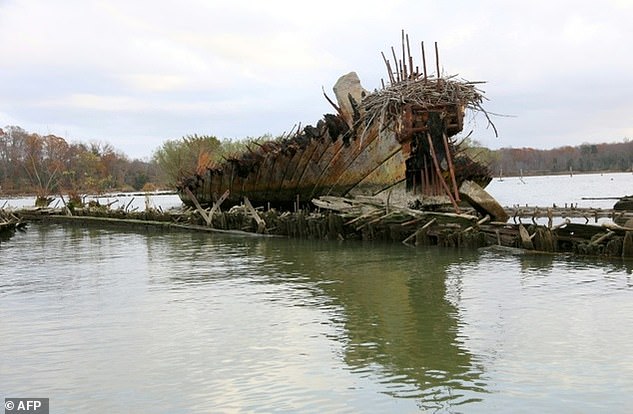
‘One of the remarkable things about Lake Erie and Great Lakes shipwrecks is how well they are preserved due to the cold, freshwater,’ said Magee. ‘Wrecks in saltwater start corroding immediately. In the Great Lakes, you can find old wooden ships that are hundreds of years old that look like they just sank.’

Wreck of US ship that hunted Nazi spies in the Arctic finally discovered

Wreck of US ship that hunted Nazi spies in the Arctic finally discovered

Live Science reports that the wreckage of the U.S. Revenue Cutter Bear has been found in Canadian waters by the U.S. Coast Guard, the U.S. National Oceanic and Atmospheric Administration (NOAA), and other researcher groups.

Wreck of US ship that hunted Nazi spies in the Arctic finally discovered
The US Revenue Cutter Bear was capable of sailing through Arctic ice.

The Bear has a storied history: It started working as a commercial sealer in 1874. Then, because the ship could travel through ice-filled waters, the government purchased it in the 1880s to use for rescue work in the Arctic. It also served as a relief ship during the Spanish flu pandemic of 1918-1919, a floating museum, a film set for a Hollywood movie and an expedition ship on Adm. Richard Byrd’s Antarctic explorations.

It also patrolled Arctic waters for the U.S. Navy in both world wars, and in 1941 it helped capture the Norwegian trawler Buskø, which was being used by the German military intelligence service Abwehr to report on weather conditions in the North Atlantic.

The Bear was decommissioned in 1944 and tied up at a wharf in Halifax, Nova Scotia. It finally sank after a storm in 1963, somewhere south of Nova Scotia and east of Boston, as it was being towed to Philadelphia.

“The Bear has had such an incredible history, and it’s so important in many ways in American and global maritime heritage because of its travels,” said Brad Barr, the mission coordinator for the U.S. National Oceanic and Atmospheric Administration’s (NOAA) Maritime Heritage Program, who has led the search for the wreck for several years.

A scan of the wreck is believed to be the Bear.

Historic ship

In the late 1970s, a group started searching for the Bear. It included the Massachusetts Institute of Technology’s Harold Edgerton, who invented side-scan sonar — a technology widely used today to detect and image objects on the seafloor.

The group tested out the new side-scan technology in 1979, but they didn’t find the wreck — possibly because the location of its sinking had been misreported by its tow ship, Barr told Live Science..

A secret Navy submersible — the nuclear-powered NR-1 —— carried out a second search in 2007, but it too was unsuccessful. Finally, the U.S. Coast Guard and NOAA joined forces with other partners and began another search in 2019.

After mapping 62 square miles (160 square kilometres) of seafloor with sonar, they identified two submerged objects in the search area. In September, they returned on a Coast Guard ship equipped with a remotely operated vehicle (ROV) to take underwater video and confirm that the largest object is the wreck of Bear, Barr said.

The wreck now lies on the seafloor at a depth of about 200 feet (60 meters), in Canadian waters about 90 nautical miles (167 km) south of Nova Scotia’s Cape Sable. The exact location is being kept confidential in the hopes of deterring technical divers from trying to reach it, Barr said. The search partners are discussing with the Canadian government how the wreck can be protected.

The ageing wooden hull has been badly damaged by nets from fishing trawlers and strong currents on the seafloor. But the researchers identified several distinctive features of the Bear, including the “bow staples” that strengthened its hull to allow the ship to handle heavy ice in polar waters, Barr said. 

An image of the wreck taken by a remotely controlled vehicle.

Steamship to diesel

Although the Bear was equipped with three masts for sailing, it was built as a steamship for its role as a sealer in the 1870s. In the 1930s, the boiler was taken out and the steam engine was replaced with a diesel engine as it was refitted for its Antarctic service with Byrd. 

As a result, several piles of metal can be seen among the remaining wood of the wreck, which includes sailing-ship technologies, Barr said. 

“There’s a pile of metal rubble with a deadeye [a fixed wooden pulley] sticking up out of it,” he said. “These deadeyes have been around since the 1700s, but they were used on the Bear to attach the standing rigging.”

Among the Bear’s most famous exploits was its part in the 1884 rescue fleet for the Greely Expedition to the Arctic, which had become lost in 1881 near Ellesmere Island, northwest of Greenland. Several members of the expedition died of starvation and disease before the Bear rescued Greely and the other survivors. 

After serving for many years as a government revenue cutter in Arctic waters — intercepting and inspecting ships at sea, and often rescuing commercial ships trapped in ice — the Bear was transferred to the Navy; it patrolled around Alaska during World War I, and it delivered supplies there during the Spanish flu pandemic.

In 1929, the decommissioned ship was given to the city of Oakland in California, where it became a floating museum and then a film set for the 1930 movie “The Sea-Wolf,” an adaption of a Jack London novel. 

READ ALSO: ARCHAEOLOGISTS DISCOVER 2200-YEAR-OLD EGYPTIAN SHIPWRECK IN THE MEDITERRANEAN SEA

The Bear was recommissioned for Arctic patrols during World War II, when it helped capture the Buskø; but it was mostly tied up in Halifax after that until it sank in 1963 on its final voyage to Philadelphia, where it was destined to become a floating restaurant.

“These are incredibly compelling stories,” Barr said. “When you read the details of what the Bear did, how many lives it saved, how many incredible missions it was on — it is really the kind of history that people should be aware of.”

To commemorate its discovery, Barr has compiled years of historical research into several website posts detailing the many exploits of the Bear. “One of the reasons why we wanted to find it is because it allows us to tell all these stories,” he said. 

‘Hellboy’ horned dinosaur species discovered in Canada

‘Hellboy’ horned dinosaur species discovered in Canada

The prehistoric creature, named Regaliceratops peterhewsi, is a close relative of the familiar Triceratops and belongs to Ceratopsidae, a group of large-bodied, plant-eating dinosaurs that evolved in the Cretaceous period and were largely restricted to western North America.

Artistic life reconstruction of Regaliceratops peterhewsi.

Ceratopsid dinosaurs are divided into two subgroups: chasmosaurines, which include Triceratops and the new species, and centrosaurines.

Centrosaurines went extinct several million years before the chasmosaurines, which went extinct at the end of the Cretaceous along with all the other dinosaurs.

Characteristically, chasmosaurines have a small nose horn, large horns over their eyes, and shield-like frills with simple scalloped edges.

Regaliceratops peterhewsi is unexpected because it shows the exact opposite pattern: large nose horn, small horns over the eyes, and elaborately decorated frills similar to centrosaurines. This demonstrates that at least one group of chasmosaurines evolved ornamentation similar to centrosaurines following their extinction.

“This new species is a chasmosaurine, but it has ornamentation more similar to centrosaurines. It also comes from a time period following the extinction of the centrosaurines,” said Dr Caleb Brown, lead author on the study published in the journal Current Biology.

“Taken together, that makes this the first example of evolutionary convergence in horned dinosaurs, meaning that these two groups independently evolved similar features.”

‘Hellboy’ horned dinosaur species discovered in Canada
Citizen palaeontologist Peter Hews with the skull of Regaliceratops peterhewsi that he found.

The nearly intact skull of Regaliceratops peterhewsi was discovered by Calgary resident Peter Hews, a geologist in the petroleum industry, in southeastern Alberta in 2005.

“The specimen comes from a geographic region of Alberta where we have not found horned dinosaurs before, so from the onset we knew it was important,” Dr Brown said.

Despite the formal name, Dr Brown and his co-author, Dr Donald Henderson, said they’ve taken to calling this dinosaur by the nickname ‘Hellboy’ (after the comic book character).

“It’s due to the difficulty collecting the specimen and for the challenging preparation process to remove it from the very hard rock in which it was encased,” the scientists said.

“Upon discovery, it was instantly noticeable that this specimen was something that had never been seen before, especially considering its unlikely location and unique features.”

The palaeontologists said they hope to uncover more specimens of Regaliceratops peterhewsi.

Dr Brown added: “This discovery also suggests that there are likely more horned dinosaurs out there that we just have not found yet, so we will also be looking for other new species.”

Is this the rock that proves Vikings did discover America?

Is this the rock that proves Vikings did discover America?

They are infamous for terrorising the coastlines of Europe in their distinctive longships, but the Vikings may be able to claim another victory over their medieval neighbours. New evidence has been uncovered that suggests the Vikings may have discovered North America nearly 500 years before Christopher Columbus made his famous journey to the New World. Scientists claim to have uncovered what they believe to be a Viking settlement on the Canadian island of Newfoundland that appears to have been built between 800AD and 1300AD.

Is this the rock that proves Vikings did discover America?
New evidence of a Viking settlement in North America has been unearthed in Newfoundland (a hearth where iron ore appears to have been roasted is pictured) which suggests the Scandinavians were the first Europeans to set foot in the New World around 500 years before Christopher Columbus

It is only the second known Viking site to be discovered in North America and helps to confirm that they were the first Europeans to reach the New World. This new site, discovered in an area called Point Rosee in southern Newfoundland, is 400 miles (643km) south west of a Viking settlement found in L’Anse aux Meadows during the 1960s. Archaeologists said the discovery potentially opens ‘a new chapter’ in history by showing the Vikings had explored far further into the New World than previously believed possible.

Dr Sarah Parcak, an archaeologist at the University of Alabama, Birmingham, explained: ‘This new site could unravel more secrets about the Vikings, whether they were the first Europeans to ‘occupy’ briefly in North America and reveal that the Vikings dared to explore much further into the New World than we ever thought.

The new Viking settlement was found on the edge of Point Rosee in Newfoundland (illustrated above) 400 miles south of another site at L’Anse aux Meadows. They suggest that the Vikings’ mastery of the seas allowed them to venture to North America (illustrated on the map)

‘Typically in archaeology, you only ever get to write a footnote in the history books, but what we seem to have at Point Rosee may be the beginning of an entirely new chapter.’

The Vikings are well known to have been adept seafarers, using the sun and the stars to help pick their way across open stretches of ocean away from the coastline. It is thought the Vikings first discovered America by accident in the autumn of 986AD, according to one historical source, the Saga of the Greenlanders. It tells how Bjarni Herjolfsson was stumbled across North America after being blown off course as he attempted to sail from Norway to Greenland, but he did not go ashore. Inspired by his tales, however, another Viking Leif Ericsson then mounted his own expedition and found North America in 1002.

Finding it fertile land, rich in grapes and berries, he named it Vinland. Eriksson also named two further ‘lands’ on the North American coast – one with flat stones, which he called Helluland, and one that was flat and wooded, named Markland. The discovery of the settlement at Point Rosee now helps to confirm that these legends were in fact true. The settlement uncovered by Dr Parcak, who has been working with the BBC and a team of experts, was initially spotted using high resolution near-infrared images taken by satellites.

Archaeologists found evidence of stones blackened by iron ore processing (pictured), something that the indigenous North American population were not thought to do. It suggests the buildings that stood at the site were inhabited by Vikings, who made extensive use of iron
Using infrared images (pictured) of the site, the archaeologists were able to see the outlines of what they believe were longhouses similar to those used by the Vikings

Over time the structures have altered the soil and the way it retains moisture, changing the vegetation that grow above, making it possible to see the outline of the structures in satellite images. These helped them identify intriguing patterns in Point Rosee, which indicated there were some manmade features and the possible outline of a longhouse similar to those used by the Vikings. During excavations of the site, the team uncovered evidence possible bog iron ore processing.

The settlement at L’Anse aux Meadows was the only other site where pre-Columbian iron processing has been found in North America. The archaeologists discovered around 28lbs of slag in a hearth that they believe was used to roast iron ore before it was smelted in a furnace. Blackened stones, scorched by the extreme heat in this process, were also unearthed at the site. 

Point Rosee is a peninsula on the most south westerly tip of the island of Newfoundland (pictured). It provided a perfect location for the Vikings to set up an outpost, the archaeologists claim
Researchers found pieces of slag (pictured) in a hearth that they believe was used to roast iron ore prior to smelting it in a furnace at the site in Newfoundland, which suggests it was inhabited by Vikings

While Inuits are thought to have used some iron from meteors, there is no other evidence of indigenous people processing iron.  The longhouse building they identified appears to have been built using turf, in much the same style as other Viking structures. Black bands in the soil as the team excavated betrayed the presence of turf building blocks that had been used to construct a building. Douglas Bolender said: ‘Right now the simplest answer is that it looks like a small activity area maybe connected to a larger farm that’s norse.

‘If we were in Iceland we wouldn’t think twice about that. But the thing that makes you pause and check every last little bit of it, is that it is in Newfoundland.’ 

If they are right, it means Rosee Point is the most westerly Viking outpost yet discovered. Dr Bolender told National Geographic it could mean that the Viking sagas detailing journey’s to what has been interpreted as North America are true rather than merely legends.

He said: ‘We’re looking here because of the sagas. Nobody would have ever found L’Anse aux Meadows if it weren’t for the sagas. But, the flipside is that we have no idea how reliable they are.’

The remains of a Viking ship burial unearthed in Estonia also features in the BBC documentary (Dan Snow with some of the weapons and artefacts found there are pictured)
Smashed bones thought to have belonged to a Viking were found at a battlefield in Estonia (pictured)

Although the archaeologists leading the excavation are convinced the site was inhabited by Vikings, they say further work is needed to conclusively prove it was a Viking settlement. Nonetheless, Professor Judith Jesch, director of Nottingham University’s Centre for the Study of the Viking Age who was not involved in the discovery, described the find as ‘exciting’. 

She told the told The Telegraph that L’Anse aux Meadows may have been a way-centre as the Vikings ventured further south and that it is likely other sites may yet be unearthed.

She said: ‘Finding Vikings in the United States is the Holy Grail for many people, not least because there are many Americans of Scandinavian descent who would like to think that they were following in the footsteps of their ancestors.

‘But I don’t think they made significant progress past New Brunswick, in Canada.’

The discovery is outlined in a one-off 90 minute BBC documentary called Vikings Uncovered. It will be aired on BBC One in the UK. During the program, historian Dan Snow travels throughout the lands inhabited by the Vikings to explore just how far their influence spread.

Among the other discoveries outlined in the documentary are the remains of a battlefield in Estonia. Smashed bones were found alongside weapons and a Viking ship burial. In Portmahomack in Easter Ross, in the Scottish Highlands, archaeologists have discovered evidence that a monastery there was utterly destroyed by a Viking raid. Smashed sculptures were found with the ashes of the buildings of what had been once a prosperous community.

Skull fragments found at the site – thought to have belonged to monks – reveal the violence of the attack. Speaking about the find in Newfoundland, Mr Snow said: ‘The Vikings Uncovered was one of the most exciting projects of my career.

‘I was able to follow Dr Sarah Parcak and her team as they carried out pioneering research, using satellite imagery, in an attempt to unlock one of history’s greatest mysteries.

‘Were the Vikings really the first Europeans to settle North America? We know of one Viking site on the very northern tip of Newfoundland but was this part of a wider Viking territory?

‘It felt like Sarah’s team were making history, both in the high tech labs and on the ground in windswept Newfoundland, and I got to watch the entire process.’

Oldest Horseshoe Crab Fossil Found, 445 Million Years Old

Oldest Horseshoe Crab Fossil Found, 445 Million Years Old

Few modern animals are as deserving of the title “living fossil” as the lowly horseshoe crab. Seemingly unchanged since before the Age of Dinosaurs, these venerable sea creatures can now claim a history that reaches back almost half a billion years.

The oldest horseshoe crab in the fossil record (Lunataspis aurora, left) is 445 million years old and was discovered in Ordovician strata from Manitoba, Canada. Horseshoe crab shells are made of protein and normally are not mineralized like typical fossils, making this a truly remarkable find. Despite the age of this fossil, it looks remarkably similar to the modern animal pictured to the right

In a collaborative research article published recently in the British journal Palaeontology, a team of Canadian scientists revealed rare new horseshoe crab fossils from 445 million-year-old Ordovician age rocks in central and northern Manitoba, which are about 100 million years older than any previously known forms.

Palaeontologist Dave Rudkin from the Royal Ontario Museum, with colleagues Dr. Graham Young of The Manitoba Museum (Winnipeg) and Dr. Godfrey Nowlan at the Geological Survey of Canada (Calgary), gave their remarkable new fossils the scientific name Lunataspis aurora, meaning literally “crescent moon shield of the dawn” in reference to their shape, geological age and northerly discovery sites.

Although they are more “primitive” in several aspects than other known horseshoe crabs, their resemblance to living forms is unmistakable.

The fossil horseshoe crabs were recovered in the course of fieldwork studies on ancient tropical seashore deposits, providing yet another important link to their modern descendants that are today found along warmer seashores of the eastern United States and the Indian Ocean.

One of the fossils of the new genus of horseshoe crab (Lunataspis aurora) was photographed underwater to show some of the fine details.

This is particularly significant, explains Rudkin. “Understanding how horseshoe crabs adapted to this ecological niche very early on, and then remained there through thick and thin, can give us insights into how ocean and shoreline ecosystems have developed through deep time.”

Today, marine shorelines worldwide are being threatened by human activity, and although some horseshoe crab populations are endangered, their enviably long record on Earth indicates that they have successfully weathered many previous crises, including the mass extinction that saw the demise of the dinosaurs and many other life forms 65 million years ago.

“We do need to be concerned about horseshoe crabs and many of the other unusual life forms found on marine shores,” said Dr. Young.

“Nevertheless, we can also be mildly optimistic that some of these things have demonstrated a toughness that may allow them to survive our abuse of these environments.”

Living horseshoe crabs are extensively studied, especially in the fields of ecology and medical research. The exciting discovery of these unusual early fossil relatives adds a new introductory chapter to their remarkable story.

David Rudkin is Assistant Curator in the Department of Natural History (Palaeobiology) at the Royal Ontario Museum and holds an appointment to the Department of Geology, University of Toronto, as a Lecturer in palaeontology.

Rudkin joined the former Department of Invertebrate Palaeontology at the ROM in 1975 and began working on fossils from the Burgess Shale in British Columbia.

14,000-year-old ice age village discovered is 10,000 years older than the pyramids

14,000-year-old ice age village discovered is 10,000 years older than the pyramids

In their oral history, the Heiltsuk people describe how the area around Triquet Island, on the western coast of their territory in British Columbia, remained open land during the ice age.

“People flocked there for survival because everywhere else was being covered by ice, and all the ocean was freezing and all of the food resources were dwindling,” says Heiltsuk Nation member William Housty.

And late last year, archaeologists excavating an ancient Heiltsuk village on Triquet Island uncovered the physical evidence: a few flakes of charcoal from a long-ago hearth.

Analysis of the carbon fragments indicates that the village site — deserted since a smallpox epidemic in the 1800s — was inhabited as many as 14,000 years ago, making it three times as old as the pyramids at Giza, and one of the oldest settlements in North America.

“There are several sites that date to around the same time as the very early date that we obtained for Triquet Island, so what this is suggesting is that people have been here for tens of thousands of years,” says Alisha Gauvreau, a scholar at the Hakai Institute and a PhD candidate at the University of Victoria, who has been working at the Triquet Island site.

But how was it that Triquet Island remained uncovered, even during the ice age? According to Gauvreau, sea levels in the area remained stable over time, due to a phenomenon called sea level hinge.

“So all the rest of the landmass was covered in ice,” she explains. “As those ice sheets started to recede — and we had some major shifts in sea levels coastwide, so further to the north and to the south in the magnitude of 150 to 200 meters of difference, whereas here it remained exactly the same.”

The result, Gauvreau says, is that people were able to return to Triquet Island repeatedly over time. And while nearby sites also show evidence of ancient inhabitants, people “were definitely sticking around Triquet Island longer than anywhere else,” she says. In addition to finding bits of charcoal at the site, she says archaeologists have uncovered tools like obsidian blades, atlatls and spear throwers, fishhook fragments and hand drills for starting fires.

“And I could go on, but basically, all of these things, coupled with the fallen assemblage, tell us that the earliest people were making relatively simple stone tools at first, perhaps expediently, due to the parent material that was available at the time,” Gauvreau says.

The site also indicates that these early people were also using boats to hunt sea mammals, and gather shellfish, she adds. And later on, they traded or travelled great distances to obtain nonlocal materials like obsidian, greenstone and graphite for tools.

For archaeologists and anthropologists, the find bolsters an idea, called the “Kelp Highway Hypothesis” hypothesis, proposing that the first people who arrived in North America followed the coastline in boats to avoid the glacial landscape.

“It certainly adds evidence to the fact that people were able to travel by boat in that coastal area by watercraft,” Gauvreau says.

And for the Heiltsuk Nation, which has worked with the archaeologists for years to share knowledge and identify sites like Triquet Island, the updated archaeological record provides new evidence, as well. The nation routinely negotiates with the Canadian government on matters of territory governance and natural resource management — negotiations that depend in part on the community’s record of inhabiting the area over long periods.

Archaeologists at the site are unearthing tools for lighting fires, fish hooks and spears dating back to the Ice Age

“So when we’re at the table with our oral history, it’s like me telling you a story,” Housty says. “And you have to believe me without seeing any evidence.”

But now, he explains, with the oral history and archaeological evidence “dovetailing together, telling a really powerful tale,” the Heiltsuk have new advantages at the negotiating table.

“That’s really going to be very significant … and I think will definitely give us a leg up in negotiations, for sure,” he says.

The Arctic Could Turn Green and Free of Ice Like it was 125,000 Years Ago

The Arctic Could Turn Green and Free of Ice Like it was 125,000 Years Ago

Researchers analyzed plant DNA more than 100,000 years old retrieved from lake sediment in the Arctic (the oldest DNA in lake sediment analyzed in a publication to date) and found evidence of a shrub native to northern Canadian ecosystems 250 miles (400 km) farther north than its current range.

As the Arctic warms much faster than everywhere else on the planet in response to climate change, the findings, published this week in the Proceedings of the National Academy of Sciences, may not only be a glimpse of the past but a snapshot of our potential future.

“We have this really rare view into a particularly warm period in the past that was arguably the most recent time that it was warmer than present in the Arctic. That makes it a really useful analogue for what we might expect in the future,” said Sarah Crump, who conducted the work as a Ph.D. student in geological sciences and then a postdoctoral researcher with the Institute of Arctic and Alpine Research (INSTAAR).

To gain this glimpse back in time, the researchers not only analyzed DNA samples, they first had to journey to a remote region of the Arctic by ATV and snowmobile to gather them and bring them back.

Dwarf birch is a key species of the low Arctic tundra, where slightly taller shrubs (reaching a person’s knees) can grow in an otherwise cold and inhospitable environment. But dwarf birch doesn’t currently survive past the southern part of Baffin Island in the Canadian Arctic. Yet researchers found DNA of this plant in the ancient lake sediment showing it used to grow much farther north.

“It’s a pretty significant difference from the distribution of tundra plants today,” said Crump, currently a postdoctoral fellow in the Paleogenomics Lab at the University of California Santa Cruz.

Tundra Plants

While there are many potential ecological effects of the dwarf birch creeping farther north, Crump and her colleagues examined the climate feedbacks related to these shrubs covering more of the Arctic. Many climate models don’t include these kinds of changes in vegetation, yet these taller shrubs can stick out above snow in the spring and fall, making the Earth’s surface dark green instead of white — causing it to absorb more heat from the sun.

“It’s a temperature feedback similar to sea ice loss,” said Crump. During the last interglacial period, between 116,000 and 125,000 years ago, these plants had thousands of years to adjust and move in response to warmer temperatures. With today’s rapid rate of warming, the vegetation is likely not keeping pace, but that doesn’t mean it won’t play an important role in impacting everything from thawing permafrost to melting glaciers and sea-level rise.

“As we think about how landscapes will equilibrate to current warming, it’s really important that we account for how these plant ranges are going to change,” said Crump.

As the Arctic could easily see an increase of 9 degrees Fahrenheit (5 degrees Celsius) above pre-industrial levels by 2100, the same temperature it was in the last interglacial period, these findings can help us better understand how our landscapes might change as the Arctic is on track to again reach these ancient temperatures by the end of the century.

Mud as a microscope

To get the ancient DNA they wanted, the researchers couldn’t look to the ocean or to the land — they had to look in a lake. Baffin Island is located on the northeastern side of Arctic Canada, kitty-corner to Greenland, in the territory of Nunavut and the lands of the Qikiqtaani Inuit. It’s the largest island in Canada and the fifth-largest island in the world, with a mountain range that runs along its northeastern edge. But these scientists were interested in a small lake, past the mountains and near the coast.

Above the Arctic Circle, the area around this lake is typical of a high Arctic tundra, with average annual temperatures below 15 °F (?9.5 °C). In this inhospitable climate, the soil is thin and not much of anything grows.

But DNA stored in the lake beds below tells a much different story. To reach this valuable resource, Crump and her fellow researchers carefully balanced on cheap inflatable boats in the summer — the only vessels light enough to carry with them — and watched out for polar bears from the lake ice in winter. They pierced the thick mud up to 30 feet (10 meters) below its surface with long, cylindrical pipes, hammering them deep into the sediment.

The goal of this precarious feat? To carefully withdraw a vertical history of ancient plant material to then travel back out with and take back to the lab. While some of the mud was analyzed at a state-of-the-art organic geochemistry lab in the Sustainability, Energy and Environment Community (SEEC) at CU Boulder, it also needed to reach a special lab dedicated to decoding ancient DNA, at Curtin University in Perth.

To share their secrets, these mud cores had to travel halfway across the world from the Arctic to Australia.

A local snapshot

Once in the lab, the scientists had to suit up like astronauts and examine the mud in an ultra-clean space to ensure that their own DNA didn’t contaminate that any of their hard-earned samples.

It was a race against the clock.

“Your best shot is getting fresh mud,” said Crump. “Once it’s out of the lake, the DNA is going to start to degrade.”

This is why older lake bed samples in cold storage don’t quite do the trick. While other researchers have also collected and analyzed much older DNA samples from permafrost in the Arctic (which acts as a natural freezer underground), lake sediments are kept cool, but not frozen. With fresher mud and more intact DNA, scientists can get a clearer and more detailed picture of the vegetation which once grew in that immediate area.

Reconstructing historic vegetation has most commonly been done using fossil pollen records, which preserve well in sediment. But pollen is prone to only showing the big picture, as it is easily blown about by the wind and doesn’t stay in one place. The new technique used by Crump and her colleagues allowed them to extract plant DNA directly from the sediment, sequence the DNA, and infer what plant species were living there at the time. Instead of a regional picture, sedimentary DNA analysis gives researchers a local snapshot of the plant species living there at the time. Now that they have shown it’s possible to extract DNA that’s over 100,000 years old, future possibilities abound.

“This tool is going to be really useful on these longer timescales,” said Crump. This research has also planted the seed to study more than just plants. In the DNA samples from their lake sediment, there are signals from a whole range of organisms that lived in and around the lake.

“We’re just starting to scratch the surface of what we’re able to see in these past ecosystems,” said Crump. “We can see the past presence of everything from microbes to mammals, and we can start to get much broader pictures of how past ecosystems looked and how they functioned.”

12 Year Boy discovers rare dinosaur skeleton in a remote part of Canada

12 Year Boy discovers rare dinosaur skeleton in a remote part of Canada

A 12-year-old boy made the discovery of his lifetime when he discovered a dinosaur fossil dating back 69 million years.

An amateur palaeontologist was walking with his father in a fossil-rich part of Alberta, Canada this July, when he saw bones protruding out of a rock. On Thursday, the skeleton’s excavation was completed.

The kid, Nathan Hrushkin, says that when he first looked at the bones, he was “literally speechless.”

12 Year Boy discovers rare dinosaur skeleton in a remote part of Canada
Nathan Hrushkin, 12, and his father, Dion, discovered the partially exposed bones while hiking with friends in Horseshoe Canyon near Drumheller, Alberta.

“He told the BBC, “I wasn’t even excited, even though I know I should have [been]. “I was in so much shock that I had actually found a dinosaur discovery.”

Nathan, who has been interested in dinosaurs since he was six, often goes hiking in the Nature Conservancy of Canada’s protected site in the Albertan Badlands with his father.

“I’ve always just been so fascinated with how their bones go from bones like ours to solid rock.”

A year ago, they had found small fragments of fossils, and his father guessed that they were falling down from the rock above. So this summer Nathan decided to inspect. The fossilised bones were poking out of the side of a hill.

“Dad, you got to get up here!” he called to his father.

His father knew Nathan had found something by the tone of his voice.

“They looked like bones made of stone – you could not mistake them for anything else,” his father, Dion Hrushkin, said.

“It looked like the end of a femur – it had that classic bone look to it – sticking straight out of the ground.”

The bones belong to a young hadrosaur and have been dated at around 69 million years old.

Nathan knows that the fossils are protected by law, so when they got home, he and his father logged in to the website for the Royal Tyrrell Museum, which is located in Alberta and devoted to the study of prehistoric life. The museum advised them to send photos of their discovery and its GPS coordinates, which they duly did.

The Badlands are home to many fossils, and a dinosaur – named the Albertosaurus – was discovered by Joseph Tyrell in the late 1800s. But the part of the conservation site where they were walking was not known for fossil discoveries, so the museum sent a team of experts to excavate.

So far they have found between 30 and 50 bones in the canyon’s wall, all belonging to one young Hadrosaur, estimated to be aged about three or four.

“I was probably like most kids, the Tyrannosaurus Rex was probably my favourite kind [of dinosaur],” Nathan says.

“But after my discovery, it’s most definitely the Hadrosaur.”

The dinosaur is scientifically significant, the museum claims, because the fossil is about 69 million years old, and records from that time period are rare.

“This young Hadrosaur is a very important discovery because it comes from a time interval for which we know very little about what kind of dinosaurs or animals lived in Alberta. Nathan and Dion’s find will help us fill this big gap in our knowledge of dinosaur evolution,” the museum’s palaeo-ecology curator, François Therrien, said in a statement.

Nathan says he’s enjoyed learning more about dating dinosaur bones, and that the whole process has been “surreal”.

“It’s going to be great to see them, after months of work, finally take something out of the ground,” he says.