HUNDREDS Of Megalithic Monuments Discovered Around Stonehenge
In a groundbreaking news release, archaeologists have revealed the results of a four-year-long project to map the hidden landscape beneath the surface of the Stonehenge environs, and what they found is nothing short of amazing.
Through their high-tech devices, they could see a landscape teeming with burial mounds, chapels, shrines, pits, and other structures, which had never been seen before, including another massive megalithic monument composed of 60 giant stones stretched out along a 330-metre long c-shaped enclosure.
According to The Independent, the discovery dramatically alters the prevailing view of Stonehenge as the primary site in the landscape. Instead, it presents the Salisbury Plain as an active religious centre with more than 60 key locations where ancient peoples could carry out sacred rituals and fulfil their religious obligations.
“This is not just another find,” said Professor Vince Gaffney of the University of Birmingham. “It’s going to change how we understand Stonehenge.”
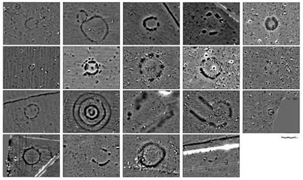
Using powerful ground-penetrating radar, which can scan archaeological sites to a depth of up to four metres, investigators from Birmingham and Bradford universities and from the Ludwig Boltzmann Institute in Vienna discovered hundreds of hidden monuments and features that cover the landscape in all directions.
The biggest surprise was a 330-metre-long line of up to 60 buried stone pillars, inside the bank of a large, bowl-shaped feature called Durrington Walls, Britain’s largest henge, which sits beside the River Avon.
The 3-metre long and 1.5-metre wide stones are laid horizontally inside the mound, although they may have once stood vertically.
“Up till now, we had absolutely no idea that the stones were there,” said Professor Gaffney.
The line of megalithic stones seems to have formed the southern arm of a c-shaped ritual enclosure which faced directly towards the river, the rest of which was made up of an artificially scarped natural elevation in the ground.
The monument was later converted from a c-shaped to a roughly circular enclosure, now known as Durrington Walls – Britain’s largest pre-historic henge, roughly 12 times the size of Stonehenge itself.
In addition to this monumental discovery, the research team found more than 60 other previously unknown pre-historic monuments scattered across Salisbury Plain, including 20 large ritual pits up to 5 metres in diameter, 8 previously unknown Bronze Age burial mounds, 4 Iron Age shrines or tombs, 6 Bronze Age and Iron Age livestock enclosures, and 17 other henge-like Neolithic and Bronze Age structures, each between 10 and 30 metres in diameter.
Some may well have consisted of circles of large timber posts – wooden equivalents of conventional prehistoric stone circles.
“It shows that, in terms of temples and shrines, Stonehenge was far from being alone,” said Professor Gaffney.
Map showing the existence of existing and newly-discovered monuments in Salisbury Plain.
Another significant discovery was a mound between Durrington Walls and Stonehenge, located approximately 3 km from Stonehenge, which has been revealed as a 33-metre long, wooden ‘House of the Dead’.
Archaeologists found evidence of ritual practices including excarnation, in which the skin and organs of the deceased were removed. The building is thought to have been used for seven generations by a single family before it was buried in chalk and forgotten for thousands of years.
A visualisation of the long barrow, which experts think was used for complex rituals, including the removal of flesh and limbs from dead bodies.
The research team is now analysing the data in an attempt to piece together exactly how Neolithic and Bronze Age people used the Stonehenge landscape. Using computer models, they are trying to work out how all the newly discovered monuments were connected with each other.
This incredible discovery has been announced ahead of a two-part special BBC Two documentary titled ‘Operation Stonehenge: What Lies Beneath, in which the research team will release the full extent of their findings.
Watch trailer of the Operation Stonehenge BBC series:
Neolithic Tomb Linked to King Arthur Investigated in England
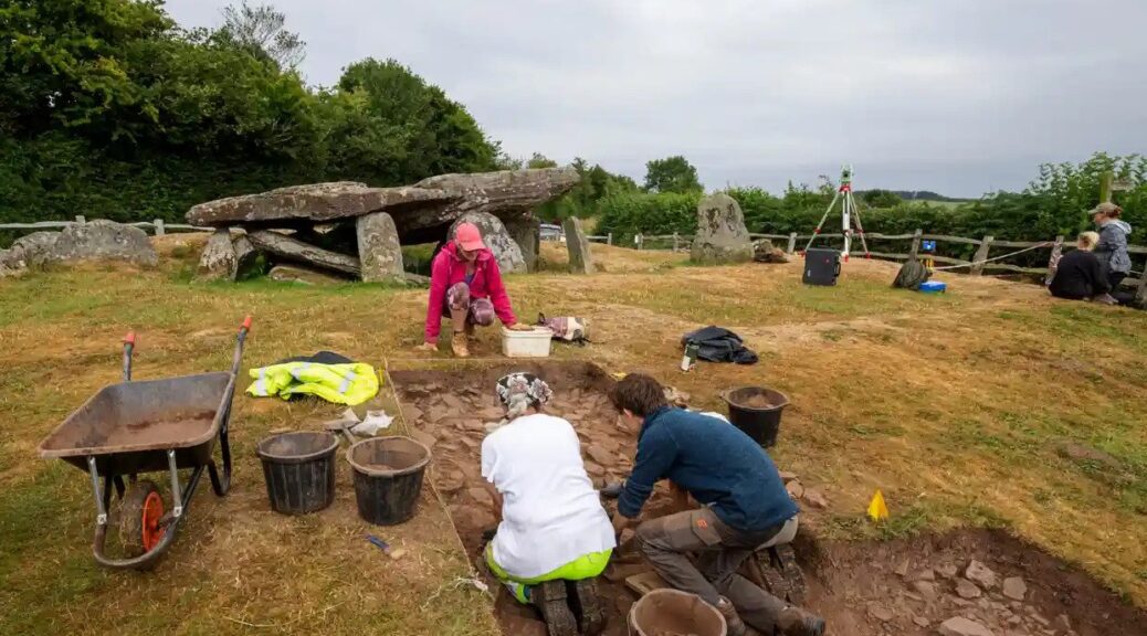
High above one of western Britain’s loveliest valleys, the silence is broken by the sound of gentle digging, scraping and brushing, along with bursts of excited chatter as another ancient feature is revealed or a curious visitor stops by to find out what is going on.
Archaeologists digging at Arthur’s Stone, Herefordshire, thought it to be an important neolithic meeting place like Stonehenge and Avebury.
This summer archaeologists have been granted rare permission to excavate part of the Arthur’s Stone site, a neolithic burial plot with soaring views across the Golden Valley in Herefordshire and the Black Mountains of south-east Wales.
Using their version of keyhole surgery, the archaeologists unearthed features, including what appear to be stone steps leading up to the 5,000-year-old tomb, and tools used by the first people to farm this landscape.
The 25-strong team have launched drones that have pinpointed possible sites of several other ancient burial spots nearby, all of which are leading them to surmise that Arthur’s Stone – like the circles at Stonehenge and Avebury – was an important meeting place and possibly part of a much larger complex of inter-related monuments.
Julian Thomas of Manchester University at the dig site.
“Arthur’s Stone is one of the most wonderful ancient monuments in the care of the nation but it’s been very poorly understood,” said Julian Thomas, a professor of archaeology at the University of Manchester, who is leading the dig. “We’re trying to do justice to it, put it in the context of what was happening in the very early neolithic.”
Over the centuries the site has inspired storytellers as well as archaeologists and historians. King Arthur was said to have killed a giant on the spot; indentations on the surface of the tomb’s capstone were supposedly made by the creature’s elbows as it fell backwards.
In the 20th century, CS Lewis is said to have used the monument as the inspiration for the stone table on which Aslan is sacrificed in The Lion, the Witch and the Wardrobe.
Thomas said the true story emerging was of a monument developed over many decades or centuries in the very early neolithic period by the first farmers and last hunter-gatherers.
He said it was becoming clear that it was almost certainly connected to two other nearby sites, Dorstone Hill, where prehistoric halls were burned and incorporated into burial mounds, and a long barrow at Cross Lodge.
The site has views across the Golden Valley in Herefordshire and the Black Mountains of southeast Wales.
The site also seems oriented towards a mountain on the horizon across the border in Wales called the Skirrid, another place steeped in myth and legend, where a landslide was said to have been caused by an earthquake or lightning strike at the moment of the crucifixion of Jesus Christ.
Keith Ray, an honorary professor of archaeology at Cardiff University, who is also overseeing the digging, said he had been asking people to look afresh at the Skirrid and imagine what it may have meant to ancient people. “I’ve thrown out one idea, it’s a bit wacky, but could it have looked like a mammoth to them and reminded them of this giant creature that used to roam here.”
Visitors have flocked to the dig from near and far. Ben Hughes, a musician based in Cardiff, said he found the site “strange, weird, wonderful, fascinating”. He said: “For me it feels like an in-between sort of place, with the more gentle landscape behind and the mountains over there. I can see why people have met here for centuries.”
Pam Thom-Rowe, an English Heritage volunteer guide, said visitors from as far away as Texas had been on site. “To me it feels like the monument is putting feelers out on the landscape.”
Thomas examines uncovered stones, and evidence of a wall around the site.
Such is the excitement at what is being found – and the public response – that the chief executive of English Heritage, Kate Mavor, is paying a visit on Friday. She said new archaeology and research continued to find fresh stories.
“Exploring a site like Arthur’s Stone is a fascinating process and something we wanted to open up to the public,” she said. “We’ve had a great response.”
Keeping an eye on the dig was Win Scutt, a properties curator at English Heritage. He said it was rare for permission to be given for this type of exploration within a scheduled monument. “This is very delicate, targeted keyhole sampling to try to answer specific questions,” he said.
Scutt said ideas about what the site was all about had changed immensely over the past few weeks – making the details on the English Heritage interpretation board out of date. “But I won’t be in too much of a rush to change it. The story will be different next year and the year after that. Which is the very exciting thing.”
Helle’s Toilet: Three-Person Loo Seat was Unusual Medieval Status Symbol
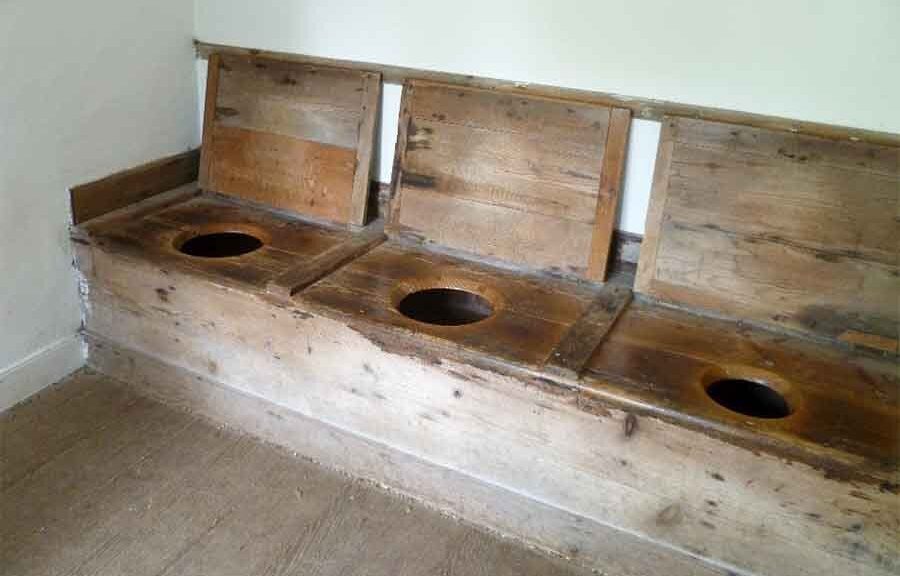
A rare 12th-century toilet seat built to accommodate three users at once is to go on display for the first time at the Museum of London Docklands.
Conservator Luisa Duarte working on the 12th-century toilet seat.
Nine hundred years after the roughly carved plank of oak was first placed over a cesspit near a tributary of the Thames, it will form the centrepiece of an exhibition about the capital’s “secret” rivers.
The strikingly well-preserved seat, still showing the axe marks where its three rough holes were cut, once sat behind a mixed commercial and residential tenement building on what is now Ludgate Hill, near St Paul’s Cathedral, on land that in the mid-1100s would have been a small island in the river Fleet.
Remarkably, archaeologists have even been able to identify the owners of the building, which was known at the time as Helle: a capmaker called John de Flete and his wife, Cassandra.
“So what I love about this is that we know the names of the people whose bottoms probably sat on it,” said Kate Sumnall, the curator of archaeology for the exhibition.
Axe marks are visible where the seat’s three rough holes were cut.
They would probably have shared the facilities with shopkeepers and potentially other families who lived and worked in the modest tenement block, she said. “This is a really rare survival. We don’t have many of these in existence at all.”
Around 50 small rivers and tributaries of the Thames are known, according to Sumnall, many of which, including the Fleet, Westbourne, Effra and Tyburn, have now been routed underground. But their influence on the topography of London has been significant, and their banks, bends and islands can still be identified in the capital’s slopes and bumps. “No one perfectly flattens the land before building the next stage,” she said.
Among the other artefacts going on display is a late bronze age sword dating from 1000BC, two Viking battleaxes and a 14th-century iron sword found in Putney, all of which appear barely corroded despite having spent centuries buried in mud.
Also on display will be a late 18th-century copper alloy dog collar, inscribed to “Tom, of the Gray Hound, Bucklers Bury” – a street close to what is now Bank – which was also excavated from the Fleet.
“We are very lucky in London that we tend to get really great preservation of a lot of things from the river,” said Luisa Duarte, the archaeological conservator.
Thanks to the low-oxygen environments of the waters and surrounding muds, she said, “in the case of the metals we have very low corrosion, and in organics, we have a very low biological activity. That’s why in London we have so much wood and leather – sometimes we have more organic Roman material than in Rome.”
The toilet seat was first excavated in the 1980s as part of what was, at the time, the largest archaeological dig in London. But because the money ran out, the findings were never published, which is why the seat has never gone on display before now.
The museum has commissioned a replica, which will form part of the exhibition and which visitors will be invited to try.
Sumnall said it was quite comfortable, but were three people to use at once “I imagine you would be touching shoulders, which would be slightly awkward.”
A Search for a Lost Hammer Led to the Largest Cache of Roman Treasure Ever Found in Britain
The Hoxne Hoard is the largest cache of late Roman silver and gold which had been discovered in Britain. It was found on 16th November 1992 in the village of Hoxne by a metal detectorist Eric Lawes who was only looking for a lost hammer.
He discovered a hoard that consists of 865 Roman gold, silver and bronze coins from the late fourth and fifth century, currently estimated at around $4.3 million.
The largest hoard of late Roman silver and gold was discovered in Britain.
The hoard contains several rare and important objects and one of them is the Empress pepper pot.
It was excavated by professional archaeologists, who estimated a particular significance in the items found, for they were largely undisturbed and intact.
The hoard was discovered in a field of a farm, about 2.4 kilometres southwest of the village of Hoxne in Suffolk.
The hoard had been placed in a wooden oak chest and within the chest, there had been some objects placed in smaller boxes while others had been wrapped in a woollen cloth.
Front view of a light miliarense coin from the Hoxne Hoard.
The Hoxne Hoard contains 569 gold coins which date to the reigns of eight different emperors, 191 silver coins (siliquae – silver coins produced from the 4th century CE) and 24 bronze coins (nummi).
The coins date after AD 407, which coincides with the end of Britain as a Roman province.
The silver Hoxne Tigress has become the best-known single piece out of over 15,000 objects in the hoard.
The jewellery in the hoard is entirely made of gold. There is one body chain, six necklaces, three rings, and nineteen bracelets.
The most precious jewel in the hoard is the body chain which is made of four finely looped gold chains, attached at front and back to plaques.
This kind of body chain can be seen in Roman art, sometimes on the goddess Venus or Nymphs.
Frontal view of the gold body chain from the Hoxne Hoard.
Piperatoria – display of a selection of spice dispensers from the hoard, the pepper-pot on the right depicts an elegant and educated ady.
One of the most important finds in the hoard is the Empress pepper pot.
The empress’ hair, clothing and jewellery are carefully represented and she is holding a scroll in her left hand, giving the impression of education as well as wealth.
There are other pepper pots in the hoard: The Hercules pepper pot and Antaeus pepper pot.
A 13 cm (5.1 in) long ladle from the hoard, with decoration including a Chi-Rho and sea-creatures.
The hoard also contains a lot of silver-gilt items: four pepper pots, a beaker, a vase, four bowls, a small dish and 98 silver spoons.
Display case reconstructing the arrangement of the hoard treasure when excavated.
Iron and organic materials from the remains of the outer wooden chest were found in large iron rings, double-spiked loops and hinges, angle brackets, iron strips, strap hinges and nails.
The most important items are on display in a perspex reconstruction of the chest at the British Museum alongside the roughly contemporary Thetford Hoard.
Sutton Hoo: One of the most magnificent archaeological finds in England
In 1939, an excavation was carried out on two 6th and 7th-century cemeteries at Sutton Hoo, near Woodbridge in Suffolk, England. Beneath Mound No. 1, a stunning archaeological discovery was made.
Historians were amazed to find an undisturbed ship burial that contained a wealth of outstanding artefacts of significant cultural and historical significance.
The archaeological team found the complete outline of the ship perfectly preserved in the sand of the burial chamber. The wood of the ship had decomposed, but the stains in the sand gave an accurate depiction of the construction of the ship, and all the metal rivets were perfectly in place.
The ship was built from oak and was found to have a tall, rising stem and stern that measured 27 meters. At its broadest part, the ship was 4.4 meters wide, and it had an inboard depth of 1.5 meters. The hull followed a clinker construction style, with nine planks on each side of the hull riveted together with iron rivets.
The ship had been laboriously carried from the river and carefully placed in a prepared trench. It was buried at a depth where only the stem and stern posts peeked out of the ground.
The body and all the funeral artefacts were then placed in the ship, and the site was covered with a soil mound. The burial place remained undisturbed until carefully uncovered by archaeologists in 1939.
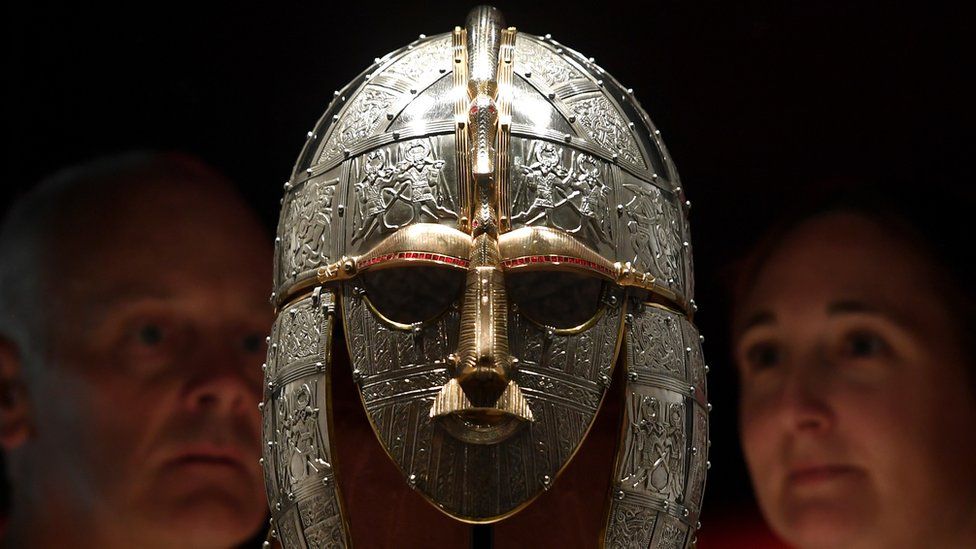
Sutton Hoo Helmet at the British Museum
This excavation was an incredibly important find, as it straddled the time in English history between myth and legends and the creation of historical documentation. It is generally accepted that the ship was the tomb of Raedwald, who was the ruler over East Anglia.
There was no body found, but analysis of the soil indicates that there was a body that had been destroyed by the acidic soil. The coffin or wooden platform that carried the body was close to 9 feet long.
From the distribution of the artefacts, it appears the head was placed at the western end of the platform. The archaeologists found an iron ringed bucket, an iron lamp that still had its beeswax fuel inside, and high-quality personal items such as a helmet, belt buckle, shoulder tabs, jewellery, coins, silverware, and armour.
The artefacts found in the tomb have provided a wealth of information about the Anglo-Saxon Kingdom of East Anglia as well as the Anglo-Saxon civilization.
Replica of the Sutton Huo Helmet in the British Museum
Only one occurrence of Middle Eastern bitumen had been found in the British Isles prior to this discovery, but the Sutton Hoo bitumen is older than the previously discovered specimen. This new discovery is very exciting, as it adds further evidence to the theory that the Anglo-Saxons traded over a far wider territory than was previously thought.
The bitumen was not left in the grave by mistake. It was deliberately placed at the head and foot of the body, and its proximity to the body indicates its value to the people. It is not clear if this bitumen was a diplomatic gift or if it was a product gained through trade routes, but its presence in the grave indicates that the Anglo-Saxons traded widely and made use of goods brought from afar.
Model of the ship’s structure as it might have appeared, with chamber area outlined Photo Credit
It is evidence that the bitumen deposits in the Middle East were traded north through the Mediterranean Sea and across Europe to reach as far north as England, Mail Online reported.
The discovery of trade goods such as this bitumen adds extensively to our understanding of how people lived in this era since the myths and legends of that time tend to obscure facts. Historians can use these artefacts to try to identify how trade routes worked, and thus learn more about how people moved and interacted so long ago.
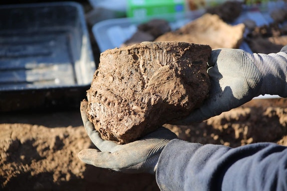
An archaeological dig has uncovered what could be the earliest house found in Cardiff. Volunteers and archaeologists from the Caerau and Ely Rediscovering (CAER) Heritage Project, found a clay pot which could be about 3,000 years old.
The clay pot found by the CAER could be about 3,000 years old
The group were looking for the missing link between the late Iron Age and the early Roman period.
Co-director of the project Dr David Wyatt said what they found was “much more remarkable.”
The archaeologists said the roundhouse, located near Cardiff West Community High School, could provide the earliest clues on the origins of Cardiff.
Over 300 people have taken part in the dig, at Trelai Park, about half a mile away from the Caerau Hillfort, a heritage site of national significance.
Archaeologists and community members had previously discovered finds of Neolithic, Iron Age, Roman and medieval origins at the hillfort.
Experts believed the settlement dubbed “Trelai Enclosure” could provide the missing link between the late Iron Age and early Roman period, showing what happened to people once they had moved on from the hillfort.
‘Incredible development’
The pot was found and recovered by archaeologist Tom Hicks and volunteer Charlie Adams
But, the roundhouse predates it, a clay pot discovered at the site has given the team a firmer indication of the time period the building can be traced to.
Dr Wyatt added that they believed the roundhouse could have been constructed in the mid to late Bronze Age, going back to between 1500 and 1100 BC.
“The enclosure definitely predates the hillfort, people were living here before the hillfort was built.
“It’s an incredible development and sheds light on the earliest inhabitants of Cardiff,” he added.
Project co-director Dr Oliver Davis said: “What we’ve found is completely unexpected and even more exciting.
“This enclosure could be providing us with the earliest clues on the origins of Cardiff, the pot that’s been found is beautifully decorated and preserved – it is extremely rare to find pottery of this quality.
“It’s also unusual to find a Bronze Age settlement in Wales – there are only one or two other Bronze Age sites in this country.”
‘Opportunity to learn’
It is hoped the ‘remarkable discovery’ will help archaeologists learn more about people living at the site
Nearly 300 volunteers have participated in the dig so far, run by CAER, a partnership between Cardiff University, Action in Caerau and Ely (ACE), local schools, residents and heritage partners.
Archaeologist Tom Hicks and volunteers Charlie Adams both found and recovered the pot during the dig.
Mr Hicks said: This is a very well-preserved example of Bronze Age pottery, and a significant find for the archaeological record in the region.
“It’s a great opportunity for us to learn more about the lives of the people living on the sire around 3,000 years ago.”
He added that further scientific analysis may be able to tell what the pot was used for before it ended up in the enclosure ditch, and how or where the pot was made.
Headteacher at Cardiff West Community High School, Martin Hullard said: “We’re delighted to be involved in this exciting archaeological project, our students have loved learning about the history that’s just a stone’s throw away from their school.”
Gold coins emerged when the earth was full; Ancient hoard of gold Roman coins discovered in plowed UK field
A cache of gold coins found buried on farmland in the United Kingdom has caught the attention of coin experts, who have linked the treasure trove to the Roman Empire.
One of the gold coins from the Roman empire was found in the English countryside. Augustus Caesar is featured on the front, and his grandson Gaius on horseback is depicted on the back.
So far, metal detectorists have discovered 11 coins on a remote stretch of cultivated field located in Norfolk, a rural county near England’s eastern coast, and experts remain hopeful that more could be unearthed in the future.
Damon and Denise Pye, a pair of local metal detectorists, found the first of several gold coins in 2017 after local farmers finished plowing the soil at the end of the harvest season, which made the land prime for exploration. The haul has been dubbed “The Broads Hoard” by local numismatists (coin specialists and collectors), for its geographic location near The Broads, a network of rivers and lakes that run through the English countryside.
“The coins were found scattered around in the plow soil, which has been churned up year after year, causing the soil to be turned over constantly and led to them eventually coming to the surface,” said Adrian Marsden, a numismatist at Norfolk County Council who specializes in ancient Roman coins.
“The first year, [the Pyes] found four coins, and the following year one more, and then they found a few more the year after that. They’ve said to me that they think they found the last one, and I always say, ‘I bet not.’ They’re slowly coming to the surface; I think there’s more.”
Marsden dated the “exceptional” bounty of gold coins to sometime between the first century B.C. and the first century A.D. Interestingly, all of the coins were minted before the Roman conquest, when Britain became occupied by Roman forces starting in A.D. 43 after an invasion launched by Rome’s fourth emperor, Claudius.
Which raises the question: How did the coins end up in a field years before the arrival of Roman forces? While Marsden said that there’s no way of knowing for sure, he thinks there could be a couple of logical explanations for the stockpile of riches.
“It’s apparent that [the coins] went into the ground before the invasion,” Marsden told Live Science. “It’s possible that they could’ve been part of some type of offering to the gods, but more likely someone buried them with the intention of recovering them later. Gold was often used as trade, so it’s possible that a local tribe could’ve gotten ahold of the coins and perhaps planned to use them for other things, such as melting them down to make jewellery.”
The fronts and backs of six of the 11 gold coins from the Roman Empire were found in the English countryside.
The farmland where the coins were found sits on land once occupied by the Iceni, a tribe of British Celts. During the Roman invasion, the tribe’s leader, Queen Boudica, led a revolt against Roman forces, attempting to drive them off their land in A.D. 60. However, despite their initial success, the queen’s army was no match for the Romans, who ultimately won the fight in what is known as the Battle of Watling Street.
The defeat led the queen to kill herself, according to the ancient Roman historian Publius Cornelius Tacitus. However, another ancient Roman historian, Cassius Dio, reported that Boudica died of illness.
In an article written by Marsden and published in a recent issue of The Searcher, a metal detectorist publication, he described there being two types of gold coins in the stash: one type was marked with the portrait of Augustus Caesar, the first emperor of Rome, with Gaius and Lucius, his grandsons and heirs to the throne, on the back of the coin. (However, both grandsons died before they could don the purple and become emperor.) The other also featured Augustus in profile on one side, but with Gaius on horseback on the reverse.
“In the second half of Augustus’ reign, when his position was consolidated, the types [of coins] with dynastic reference increased as an indication of his succession, as is the case here with the extensive coinage for his grandsons, Gaius and Lucius Caesar,” Marjanko Pilekić, a numismatist and research assistant at the Coin Cabinet of the Schloss Friedenstein Gotha Foundation in Germany, who wasn’t involved with the new findings, told Live Science. “They are depicted as the chosen successors of Augustus on the coins, which is indicated by the inscription PRINC(ipes) IVVENT(utes): ‘the first among the young.'”
Each of the coins also features a small indentation at the top, likely indicating that someone tested the coins for their purity, perhaps after they had been minted. Otherwise, “they’re high quality, 20-karat gold,” Marsden said. “If they had been churned around in the soil a lot, I would expect for them to be more scuffed up, but these are not.” Pilekić added that cutting “knicks” into the faces of gold coins was common practice in the Roman Empire, where forgeries were abundant.
“[Some can be seen] even on the portrait of Augustus,” Pilekić said. “This made it possible to check whether the coin was really a gold coin and not a gilded bronze coin, for example. The distrust must have been great, which could indicate many forgeries in circulation.”
In addition to the newfound gold coins, over the years metal detectorists have discovered a treasure trove of Roman possessions in the region, including 100 copper alloy coins, two denarii (Roman silver coins), brooches and more. According to Marsden’s estimate, the gold coins together are valued at approximately $20,000 pounds ($25,000 USD). The British Museum recently acquired the coins as part of its permanent collection.
The findings were published in the May issue of the magazine The Searcher.
“[Some can be seen] even on the portrait of Augustus,” Pilekić said. “This made it possible to check whether the coin was really a gold coin and not a gilded bronze coin, for example. The distrust must have been great, which could indicate many forgeries in circulation.”
In addition to the newfound gold coins, over the years metal detectorists have discovered a treasure trove of Roman possessions in the region, including 100 copper alloy coins, two denarii (Roman silver coins), brooches and more. According to Marsden’s estimate, the gold coins together are valued at approximately $20,000 pounds ($25,000 USD). The British Museum recently acquired the coins as part of its permanent collection.
19th-Century Industrial Site Uncovered in Southwest England
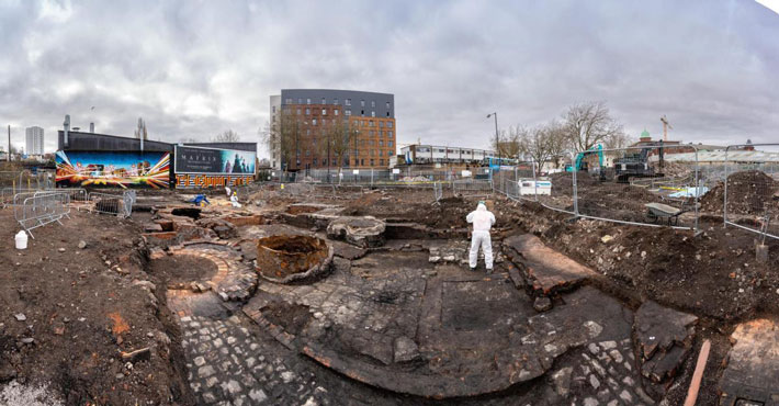
Archaeologists digging up a car park in South Bristol have unearthed the full extent of one of the city’s most ‘secretive’ companies – less than 60 years after it closed down. The team from Wessex Archaeology were given access to the old NCP car park on Dalby Avenue in Bedminster – and discovered, almost entirely intact at ground level, what was left of the site of the Bedminster Smelting Works.
And the below ground discoveries are now helping to shed more light on what was one of South Bristol’s darkest – and dirtiest – chapters, when a highly-polluting chemical work operated for more than 100 years, surrounded by people’s houses.
Just a couple of feet beneath the surface of the car park just off the A38 at Dalby Avenue in Bedminster, the archaeologists found the foundations and ground-level footprint of all the huge smelting work chimneys, furnaces, underground furnaces and stoking cellars, where generations of Bedminster residents worked in often unbearable heat and fumes. The profits from the business meant that, by the third generation of the Capper Pass family-run business, the family was able to buy a huge country estate in Dorset, far away from the fumes, smoke and stench that characterised the smelting works which stood opposite Bedminster’s main tobacco factory at the bottom of Bedminster Parade.
Wessex Archaeology carried out an excavation there between January and March this year, as work began to dig up the car park, clear the site and build huge blocks of student accommodation that will eventually house up to 837 students, as part of the massive Bedminster Green development project. One of the reasons the archaeologists were called in was because little was known about the company and how it was set up – the site was quickly demolished and covered over when it eventually closed in 1963, and the car park, Dalby Avenue and the St Catherine’s Place shopping centre was built over the top of it.
According to Simon Cox, from the Bristol and Bath Heritage Consultancy, who worked on the dig too, what went on in the smelting works was a closely-guarded secret.
“This excavation shows us that there is still a great deal to be learned about our relatively recent industrial heritage from archaeological investigations in advance of urban regeneration projects. Documentary research undertaken by Bristol & Bath Heritage Consultancy in preparation for the planning application uncovered much about the history of Capper Pass, but it was clear that they were very secretive about their processes, many of which were highly experimental and unpredictable in nature,” he said.
“The firm originated in Bedminster in the early 19th century and had premises there until the 1960s when its operations moved to its premises in Melton, Yorkshire. It ultimately became globally important as a world-leading producer of tin from secondary sources, and a wholly-owned subsidiary of Rio Tinto Zinc by the late 20th century.
The archaeological excavation of the Bedminster Smelting Works at Dalby Avenue, Bedminster
“The excavation has helped us to better understand the origins and plan form of the 19th and 20th-century works through various phases of redevelopment – information that was largely kept secret and was therefore not available through documentary sources such as historic maps and plans.
“Along with analysis of samples taken of industrial residues, this information should help us to further refine our understanding of the function of the different furnaces, solder pans and pots revealed during the work by Wessex Archaeology, and therefore the evolution of this internationally important Bedminster-based company,” he added.
The archaeologists found most of the excavated remains date from the later 19th and early 20th centuries and comprise the foundations of industrial buildings containing numerous coal-fired metal smelting furnaces with associated underground flues and stoking cellars, and the bases of three huge Lancashire boilers that provided the steam for the steam engines that powered the works.
“This has been a fascinating site to excavate,” said Wessex Archaeology’s fieldwork director Cai Mason. “It’s hard to imagine what a different place Bedminster must have been in the 19th and early 20th centuries – a densely populated area full of heavy industry, noise, and smoke.
The archaeological excavation of the Bedminster Smelting Works at Dalby Avenue, Bedminster
“Capper Pass & Sons was a very innovative and secretive company – this was the best way of preventing your competitors from stealing your ideas – and before we started our excavation, we really had no idea how the smelting works was laid out inside, or how it developed over time.
“One of the things our excavations have shown is that the company seems to have been constantly rebuilding the works. New furnaces were built, then a few years later, they’d be knocked down and replaced with a new – presumably more efficient – design. In the early days of the company it seems to have been very much a case or trial and error – were literally making it up as they went along!” he added.
The 200-year history of smelting in Bedminster
The smelting works was established 182 years ago by a local metal refiner called Capper Pass II, who had learnt his trade from his father, who had been transported to Australia for 14 years for handling stolen metal in 1819.
The junior Capper Pass bought a plot of land in Bedminster’s sprawling slums in 1840 on the new Coronation Street – a street that no longer exists, but was laid out and named after the coronation of William IV and Queen Adelaide in 1832. He built a house for his family and a small smelting work around the back, which was experimental, but not particularly successful.
The archaeological excavation of the Bedminster Smelting Works at Dalby Avenue, Bedminster
Capper Pass II tried extracting gold and silver from Sheffield plate and gilded buttons, then refining lead, copper and zinc from cheap waste products like metal ashes, slags and poor-quality ores – it didn’t exactly work and for more than 20 years the smelting works barely broke even.
But in the 1860s, the company discovered a new and highly profitable thing to manufacture – solder, the multi-purpose metal glue that was used to stick metal objects together, especially the new invention of mass-produced tin cans.
The production of solder took off, and as soon as they made enough money, the by now old Capper Pass moved the family away from the smelting works to a new large house in the new and genteel suburb of Redland, high above the stench of industrial South Bristol.
He died in 1870, but his son Alfred Capper Pass took over and expanded the business massively, moving north and south of the existing site and occupying much of the area between the ancient main road through Bedminster and the parallel railway line.
“Pass was a typical Victorian paternalistic industrialist, who used some of his wealth to help fund the Bristol General Hospital and Bristol University College and gave land for the building of St Michael’s Church on Windmill Hill,” said a Wessex Archaeology spokesperson.
From 1870 until Alfred Capper Pass’s death in 1905, the company employed more and more men in the dirty and unhealthy work in the smelting yards, and gave some money to local good causes, including helping to fund the Bristol General Hospital in Redcliffe and the University College, as well as giving land for the building of St Michael’s Church on Windmill Hill. Most of the money the family kept, however, and they were able to move out of Redland and Bristol altogether, moving to a succession of bigger and bigger homes, ending up with the purchase of a large country estate at Wootton Fitzpaine in Dorset.
The Bedminster Smelting Works, on a map dating from the 1880s
The demand for solder continued to increase into the 20th century, with the new development of electrical goods, circuit boards and cars, and the works needed to expand more – but the site was now surrounded by tightly-packed terrace homes, with space in Bedminster also in demand from the growing tobacco factories and a number of tanneries.
The company found a new site in Melton, near Hill, and from 1937 onwards, production gradually shifted there. The Bedminster Smelting Works closed in 1963 and the site was levelled, and covered with the car park and St Catherine’s Place shopping centre, with a new bypass of East Street – Dalby Avenue and Malago Road – put through the middle of it.
Now the next generation of use for the area – the Bedminster Green regeneration project – will see huge blocks of flats built in the area, including at the car park off Dalby Avenue.