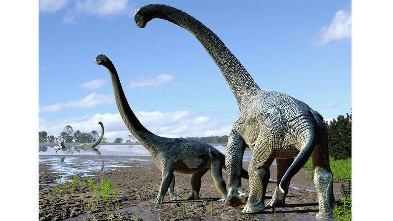
Fossil of young long-necked dinosaur found—and nicknamed Andrew
In what is now Montana, some 150 million years ago, a young dinosaur roamed through a land before (modern) time. Not yet five years old, the long-necked creature somehow ended up buried in a violent, muddy flood, forever freezing it in adolescence.

Now, researchers have freed this potentially record-setting dinosaur from its stony slumber. After uncovering the remains, the scientists published a study in Scientific Reports, in which they argue that the skull is the smallest yet found from a group of long-necked dinosaurs called diplodocids.
The little fellow even has a nickname: Andrew, after the steel baron and philanthropist Andrew Carnegie, who funded palaeontology research and has a diplodocid species named after him
With its skull just 10 inches across, researchers’ best guess is that Andrew was a juvenile Diplodocus—an especially rare find. While more than a hundred Diplodocus specimens have been discovered, their skulls are much rarer. Fewer than a dozen have been dug up to date. If the researchers’ reconstruction is correct, Andrew’s skull could be the smallest and least mature Diplodocus skull ever found, potentially providing insights into the dinosaur’s development.
“The smallest Diplodocus skull could tell us a lot about how Diplodocus grew up,” says palaeontologist D. Cary Woodruff, a PhD student at the University of Toronto and the study’s lead author.
‘Free rein at the salad bar’
Andrew hails from Montana’s Mother’s Day Quarry, a bone bed that contains at least sixteen juvenile dinosaurs, their bones are strewn about like a game of pick-up-sticks.
The remains are buried in pebble-flecked mud, suggesting that a flood may have overwhelmed a herd of young diplodocids. Due to the angles at which the bones were stuck in the muck, researchers think that other dinosaurs later trampled the bodies.
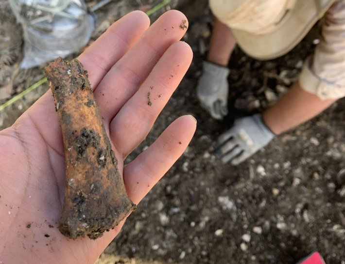
Andrew emerged from these rocks in 2010 during an excavation led by study coauthor and Cincinnati Museum Center palaeontologist Glenn Storrs. Storrs then reached out to Woodruff to give the fossil a closer look.
To Woodruff, the skull seemed to belong to a Diplodocus, though its features differed greatly from those of mature individuals. For one, Andrew had 13 teeth in its lower jaw, some of which had spoon-like edges to slice through rough vegetation. In contrast, only 11 peg-like teeth, good for nabbing softer vegetation, occupied the lower jaws of Diplodocus adults. Second, Andrew’s snout was narrow like a deer’s, whereas Diplodocus adults had broader snouts, more like a cow’s.
Woodruff thinks these differences tell the story of a shifting diet as the dinosaurs matured, echoing a 2010 study of a different Diplodocus juvenile skull.
Adult Diplodocus were lawnmowers, gobbling ferns and other soft plants in bulk. But young Diplodocus may have been more selective eaters, using their dental variation to nibble on the choicest parts of many different kinds of plants.
“Because they’ve got these different tooth types, it’s kind of like of a Swiss army knife in their mouth, right? They can pick and eat every plant they want to,” says Woodruff. “[They had] free rein at the salad bar.”
A puzzle with missing pieces
Kristi Curry Rogers, a palaeontologist at Macalester College in Minnesota, welcomes the new paper, but she doesn’t fully agree with its findings because of the fossil’s poor preservation. Andrew’s skull is missing parts of the cheek, palate, and lower jaw, plus the fossils are slightly squished. These hiccups make it hard to reconstruct the skull, let alone infer the dinosaur’s behaviour from it.

“The authors don’t address the deformation of the skull or the missing components of the face in any great detail, the inclusion of which could easily, and dramatically, change the interpretations,” she said in an email.
The uncertainty also muddies Andrew’s status as a member of the Diplodocus genus. When researchers tried to calculate Andrew’s place on the diplodocid family tree, its position depended on which of the dinosaur’s traits the researchers looked at.
“This is actually the part of the paper that I found the most interesting and important,” said palaeontologist Kimberley Chapelle, a PhD student at the University of the Witwatersrand in South Africa, in an email. The confusion may simply stem from growing pains; young and old Diplodocus could have looked very different, leading to challenges in categorization.
For now, Woodruff says that Diplodocus is his best guess for Andrew’s identity, but he says that it could also be an unknown species. To help settle the debate, Andrew’s skull is currently being 3-D scanned for future research.
“[At] the end of the day, that’s science: one object, two interpretations, multiple testable hypotheses,” said Woodruff in an email. “And if we’re later proven wrong about the identity, that’s fine. Andrew still contributes to our understanding … regardless of whatever the heck it is.”