Who Craved the Giant Handprints in the White Mountain Petroglyphs, Wyoming?
We are not in total darkness about how our ancient ancestors lived their lives thousands of years ago. One reason for this is that they etched their daily lives, including struggles, celebrations, fears, or rituals, on rocks, stones, and caves that we can see even today. These illustrations, like the White Mountain Petroglyphs, are like a historical legacy that silently tells us stories of their lives.
The White Mountain Petroglyphs are a powerful testimony to the lives of the Native American tribes who lived there between 200 and 1,000 years ago.
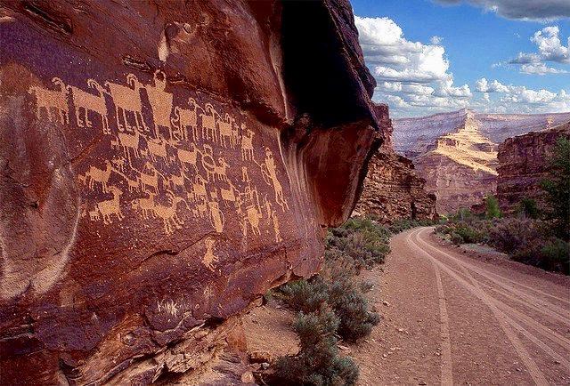
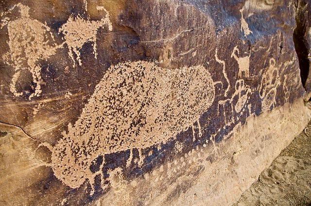
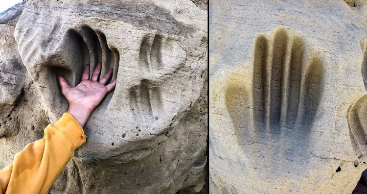
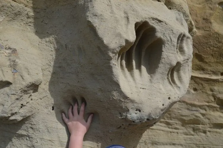
Apart from hundreds of carved figures in the area, there are giant handprints that look like someone has scooped a part of the mountain and let it solidify. These mysterious handprints are perhaps one of the most captivating things to see if you ever visit the remote White Mountains site.
Where can you find the White Mountain Petroglyphs? Who made them?
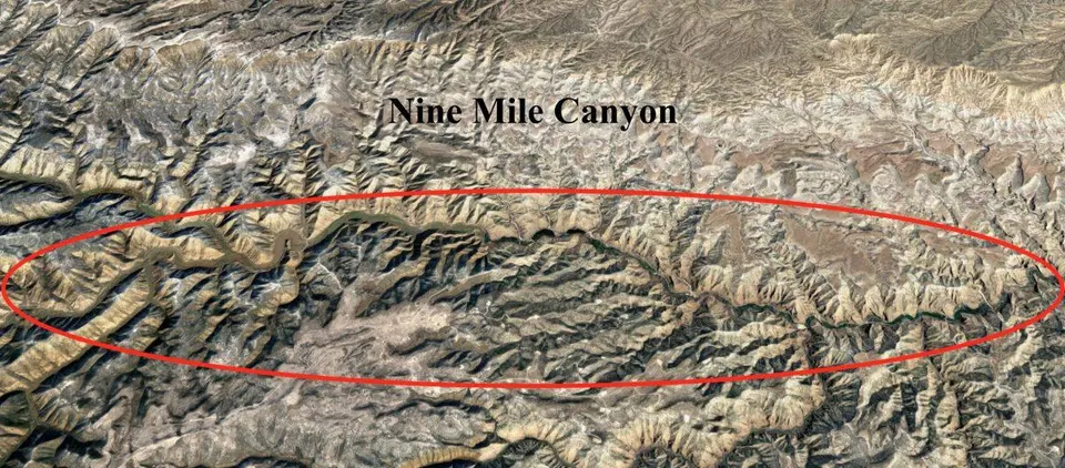
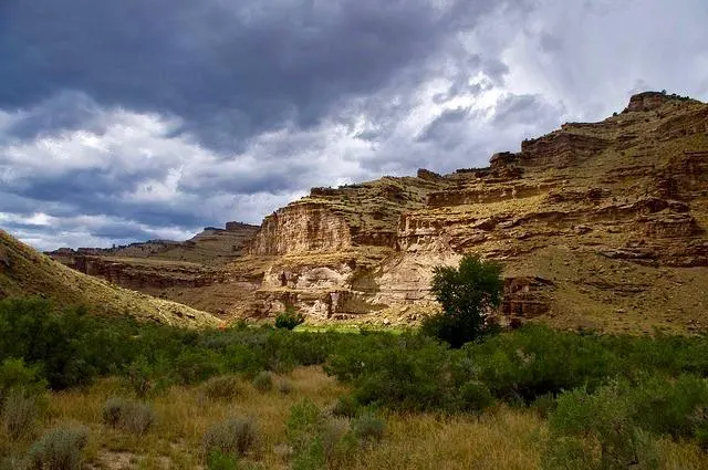
The White Mountain Petroglyph site in Wyoming’s Red Desert was once the home of Native American tribes. The site roughly starts ten miles north of Rock Springs. But to reach the White Mountains, where the petroglyphs are, one must drive 16 miles on a dirt road from the main site and walk a quarter mile on foot.
Petroglyphs (rock carvings) and pictographs (rock paintings) are the windows to the past, giving us almost a first-hand account of the lives of those who made them. Here, on the mountain face canvas, there are carvings and handprints that are the most tangible connections we have with the Great Basin Native Americans who lived there between 200 to 1,000 years ago. They include the Shoshone, Arapaho, and Ute tribes.
It is interesting to note that in other parts of the World, petroglyphs can be as old as 20,000 years. They started to diminish with the discovery and introduction of other forms of writing surfaces, different forms of art, and pictographs. But many cultures, like the Native Americans, continued to create them until contact was made with Western culture, sometimes as late as the 18th or even the 19th century.
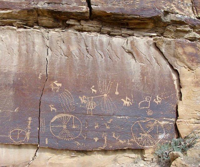
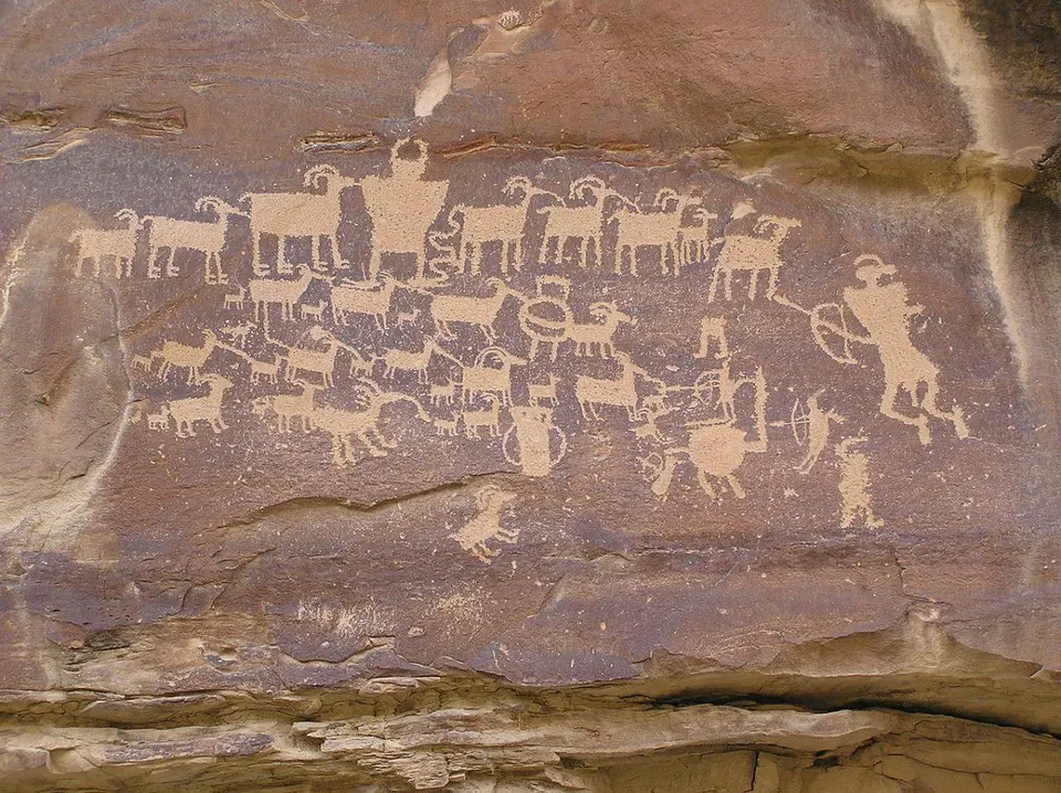
The petroglyphs have animals, symbols, and mysterious handprints.
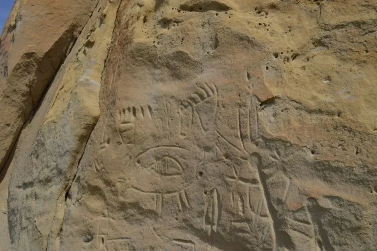
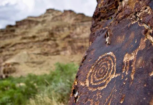
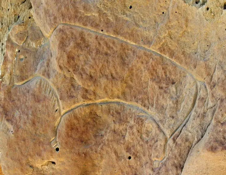
The markings tell us a lot about the beliefs and culture of the people who lived here several hundred years ago and more. There are carvings in the White Mountains that look like bison and elk hunts. There are also buffalos and wild horses carved on the rock face. Apart from the animals, there are also various interesting geometric shapes and tiny footprints that embellish the rock face.
Though not much is known about these shapes or symbols, the local Native Americans consider them sacred. They feel connected to nature and feel positive when they visit the site.
According to a Native American elder, symbols are important and communal. They feel the rocks are alive and connected to them. Some carvings also depict horses and warriors with swords. They tell us about their contact with European cultures.
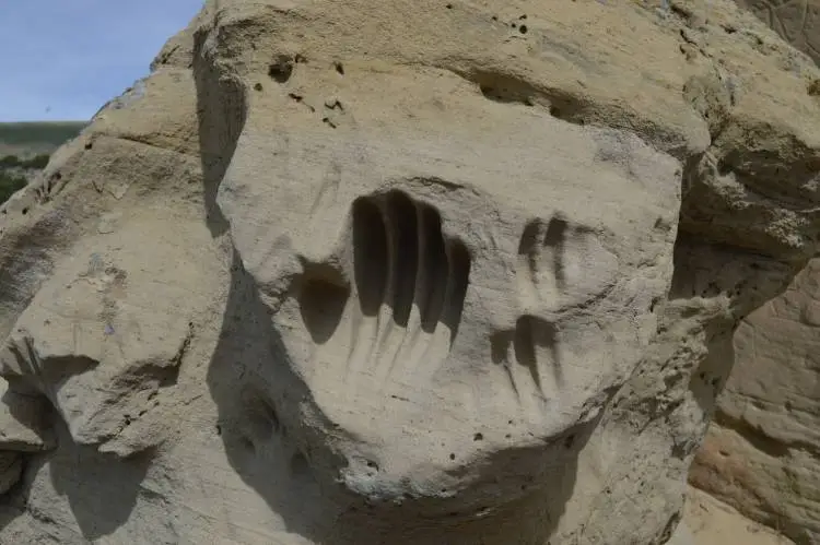
But the most mysterious of all is the deep-set handprints that are somehow left within solid sandstone as if someone had mysteriously softened the rocks. These petroglyphs are important to understand the culture and beliefs of the people who made them.
How were the deep handprints in the White Mountain Petroglyphs site made?
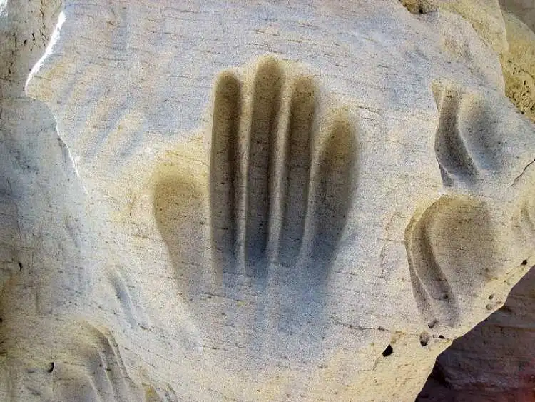
The handprints, deeply embedded in the sandstone, give an effect of mountain-scooping. According to historians, the handprints were created by the Easter Shoshone tribes between 1,000-1,800 CE. Thousands of people since then have continued to make the same motion with their hands across the soft sandstone. This, in turn, has created the effect of handprint carving deep into the rocks.
According to a website on Wyoming history, this was the birthing place for the Plains and Great Basin Tribes. The locals tell a fascinating story about how these handprints originated. Native women used to visit the White Mountains when they were giving birth. As their labor started and they had their contractions, their hands used to seek support on the mountain face and created deep handprints into the soft sandstone.
Standing against the rocks, they gave birth. Today, the site is considered sacred by Native Americans, and visitors are urged to respect the site and not destroy any part of history through vandalism. Unfortunately, though, reckless damage to the site has already happened.
Could the White Mountain Natives melt stones?
The petroglyphs on the White Mountain are made of sandstone, a softer rock that gradually hardens with time. They were probably engraved with a harder object than the sandstone. Therefore, maybe melting stones was not necessary in this case.
But what about the handprints that look like they have been scooped out of the mountain? They are deep set in solid sandstone, giving an impression that, somehow, the ancients could soften the rocks like snow. Though these have not been studied much, experts believe the birthing story might have a logical explanation. These stones were soft, and years of pushing your hands into the mountains can make these handprints really deep and big.
Not just in the White Mountains but worldwide, there are similar examples of stone bending and carvings. Scientists and historians often discuss how ancient civilizations knew advanced mechanisms to melt or soften stones.
One interesting theory, based on the shaping of stones in Peru, is that the ancients knew a plant that could melt stones. Scientists also believe ancient cultures knew advanced science and used high temperatures to shape rocks. This unknown process vitrified the surface of the rocks, turning them glasslike, on which they carved. But the process remains a mystery.
The petroglyphs in the White Mountains have not been researched, or studied by anyone formally, yet. They remain elusive and hidden, getting only 12,000 visitors a year. Let us hope when visiting the site, the visitors respect the sacredness and tread lightly to preserve the petroglyphs for as long as possible.