Inscription With Image of Babylonian King Found in Saudi Arabia
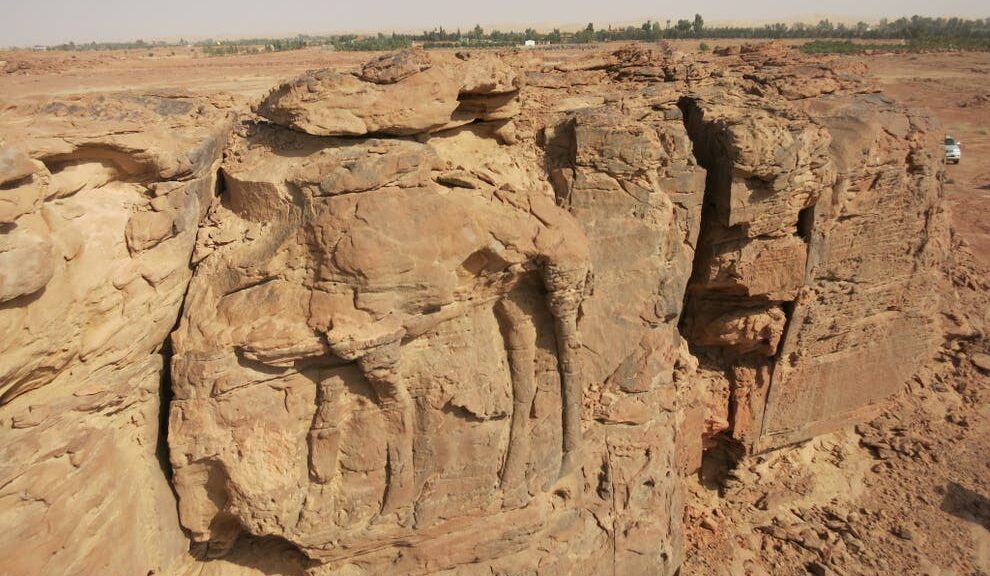
A 2,550-year-old inscription, written in the name of Nabonidus, the last king of Babylon, has been discovered carved on basalt stone in northern Saudi Arabia, the Saudi Commission for Tourism and National Heritage recently announced.
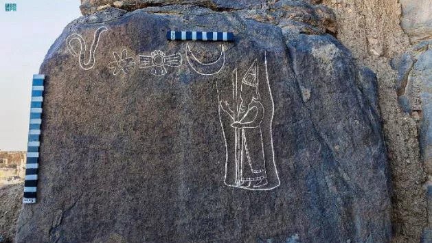
An engraving at the top of the inscription shows King Nabonidus holding a scepter alongside four other images that include a snake, a flower and a depiction of the moon, the commission said in a statement, noting that these symbols likely have a religious meaning.
These engravings are followed beneath by about 26 lines of cuneiform text that experts with the commission are currently deciphering. This is the longest cuneiform inscription ever found in Saudi Arabia, the commission said in the statement.
The top of the inscription from the last king of Babylon shows engravings showing Nabonidus and four symbols.
The inscription was found in Al Hait in the Hail Region of northern Saudi Arabia. Known as Fadak in ancient times, Al Hait holds numerous ancient sites, including the remains of fortresses, rock art and water installations, the commission said. “[It] has great historical significance from the first millennium [B.C.] until the early Islamic era.”
King Nabonidus
It remains to be seen what new information this inscription will provide on King Nabonidus (reign 555–539 B.C.).
The Babylonian Empire stretched from the Persian Gulf to the Mediterranean Sea, and at the start of Nabonidus’ reign, he conquered part of what is now Saudi Arabia and ultimately chose to live at Tayma, a city in what is now Saudi Arabia, until around 543 B.C.
Why Nabonidus chose to live in what is now Saudi Arabia for an extended period of time is a matter of debate among historians, with some experts saying that conflicts between Nabonidus and Babylon’s priests and officials are a likely reason.
At the end of Nabonidus’ reign, the Babylonian Empire came under attack by the Persian Empire, which was led by King Cyrus the Great;
Babylon itself was captured by the Persians in 539 B.C. and the Babylonian empire collapsed. The fate of Nabonidus after the collapse is unclear.
These mysterious stone structures in Saudi Arabia are older than the pyramids
Hundreds of stone monuments scattered across northwestern Saudi Arabia may represent the oldest known ritual site on Earth. Researchers studying mustatils, courtyards made from sandstone blocks, date them to about 7,000 years ago, making them millennia older than Stonehenge or the Pyramids at Giza.
Surveying the region by helicopter, the team found over 1,000 mustatils, more than twice the previous estimates.
The theory is that the structures were used during the ritual by members of a cattle cult, who sacrificed cows, goats and sheep to their unknown god.
The “head” of a mustatil consists of a larger wall of stones and contains a small niche or chamber; researchers have found animal bones in at least one of the chambers, which suggests it was used to make sacrificial animal offerings.
The mustatils, named after the Arabic word for rectangle, received little attention when they were first discovered in the 1970s.
More recently, archaeologists at the University of Western Australia in Perth explored the mysterious structures, flying by helicopter over 77,000 square miles of AlUla and Khaybar.
They found more than 1,000 mustatils– over twice as many as previously thought existed. The structures range in length from 65 feet to nearly 2,000 feet, with some sandstone boulders used to make them weigh half a ton.
Typically, a mustatil had long walls around a central courtyard, with an entry at one end and rubble platform, or ‘head,’ at the other.
They may also include an orthostat, or upright stone, in a central chamber. Some entranceways were blocked up with rubble, suggesting the structures were decommissioned at some point.
Mustatils were typically clustered in groups of between 2 and 20 and, given their monumental size, large groups of people would have had to work together to build them.
Researchers are documenting the mustatils and other ancient rock constructions by satellite photographs, helicopter reconnaissance and ground surveys.
Earlier studies speculated the structures were used as pens for livestock, but the walls of the mustatils were too low to enclose animals. In a report published this week in the journal Antiquity, researchers say they believe the strange courtyards were used for religious rites.
‘It’s not designed to keep anything in, but to demarcate the space that is clearly an area that needs to be isolated,’ lead author Hugh Thomas told New Scientist.
Fragments of cow, sheep, goats and gazelle horns and skulls found at one mustatil suggest the society that built them used animal sacrifices in their rituals.
The recent excavations reveal ‘the earliest evidence for a cattle cult in the Arabian Peninsula,’ the team’s report reads. ‘As such, mustatils are amongst the earliest stone monuments in Arabia and globally one of the oldest monumental building traditions yet identified.’
There may have been a procession involved with the ritual, as the mustatils’ narrow entranceways ‘indicate that the structures were accessed in single file,’ the team wrote.
Researchers think the mustatils scattered throughout the region were built about 7000 years ago for rituals and processions, and that they may have been part of a Neolithic cult of cattle.
By radiocarbon dating the skulls, Thomas and his colleagues dated the mustatil to between 5300 and 5000 BC, predating Stonehenge by more than 2,500 years and making them ‘the first large-scale, monumental ritual landscape anywhere in the world,’ according to co-author Melissa Kennedy, assistant director of the Aerial Archaeology in the Kingdom of Saudi Arabia project (AAKSA).
Rock art in the era from the same time period showed ‘scenes of both cattle herding and hunting,’ the team wrote, lending credence to the cattle-cult theory.
Kennedy told Art Newspaper the structures’ widespread distribution, size and uniformity ‘suggests a common religious belief may have been held over a huge part of northwest Arabia during the Late Neolithic, a feature that is so far unparalleled anywhere in the world.’
Arabian cult may have built 1000 monuments older than Stonehenge
The Arabian Peninsula is home to more than 1,000 ancient monuments that are more than 2,500 years older than the U.K.’s Stonehenge. Called “mustatils,” which is the Arabian term for “rectangles,” these rectangular stone structures were likely used by Arabian cattle herders to perform rituals.
Researchers from the University of Western Australia arrived at this conclusion after excavating the site in northwestern Saudi Arabia. They uncovered cattle horns and skulls in one mustatil, suggesting that ancient Arabians might have used cattle fragments as ritual offerings.
Based on the age of the skulls, the researchers posited that mustatils were built between 5300 and 5000 B.C. This would make the monuments the earliest large-scale, ritual site anywhere in the world, predating Stonehenge and the Egyptian pyramids by more than two millennia.
“This could completely rewrite our understanding of cults in this area at this time,” said team member Melissa Kennedy. She explained that religious groups located further south became focused on homes, with families displaying small shrines. But the opposite was happening in ancient Saudi Arabia with mustatils, she went on.
The researchers detailed their findings in the journal Antiquity.
Ancient Arabians likely used stone monuments to pray to weather gods
Made of blocks of sandstone piled on top of each other, mustatils were originally called “gates” because they resembled traditional European field gates when viewed from above. They were discovered in the 1970s but received little attention from archaeologists until recently.
Lead researcher Hugh Thomas and his team embarked on the largest investigation into mustatils to date to learn more about these structures.
After flying over northwestern Saudi Arabia and surveying the ground, the researchers found more than 1,000 mustatils spread across 20 million hectares, which were twice as many as previously thought to exist in the area.
There are 1000 ancient monuments across one region of Saudi Arabia
The open-air rectangular structures ranged from 65 feet to nearly 2,000 feet in length but their walls stood only around four feet high. According to Thomas, they were not designed to keep anything in but to demarcate an area that needed to be isolated.
In a typical mustatil, long walls surrounded a central courtyard that was bounded at one end by a distinctive rubble platform, or “head,” and an entryway at the opposite end. In some mustatils, the entrance was blocked by stones, suggesting that the mustatil might have been decommissioned after use.
Many structures also featured a chamber in the centre of the rubble platform. In one mustatil, the chamber contained cattle fragments that might have been used as ritual offerings to weather gods.
As the study showed, mustatils were built during the Holocene Humid Phase – a period between 8000 and 4000 B.C. during which Arabia and parts of Africa were wetter and what are now deserts were grasslands. But despite this humid environment, droughts were still common in these areas. As such, ancient Arabians might have herded and offered cattle to the gods to protect the land from changes in the weather, according to Kennedy.
Gary Rollefson, a professor of anthropology at Whitman College who was not part of the study, opined that the rituals in mustatils were also important for bringing communities together. Indeed, mustatils were typically clustered in groups of two to 10, suggesting that ancient Arabians held gatherings that were broken up into small social groups.
“The mustatils themselves are probably associated with an annual or generational coming-together of people who would normally be out with their herds and cattle,” he said. “But there’s no indication that these guys spent a lot of time around the mustatil.”
Monumental Neolithic Tomb Discovered in Saudi Arabia
According to a statement released by Taylor & Francis, the remains of a dog and 11 people have been found in a monumental tomb near the archaeological site of Al-Ula, which is located in northwestern Saudi Arabia.
The discovery came from one of the projects in the large-scale archaeological surveys and excavations of the region commissioned by the Royal Commission for AlUla (RCU).
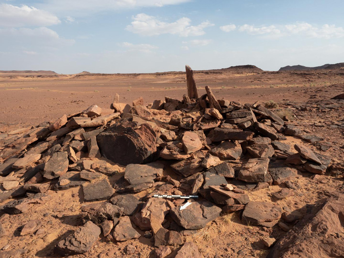
The researchers found the dog’s bones in a burial site that is one of the earliest monumental tombs identified in the Arabian Peninsula, roughly contemporary with such tombs already dated further north in the Levant.
This burial site in a badlands area of AlUla in north-west Saudi Arabia is currently rare for Neolithic-Chalcolithic Arabia in being built above-ground and meant to be visually prominent.
Evidence shows the earliest use of the tomb was circa 4300 BCE and received burials for at least 600 years during the Neolithic-Chalcolithic era – an indication that the inhabitants may have had a shared memory of people, places, and the connection between them.
“What we are finding will revolutionize how we view periods like the Neolithic in the Middle East. To have that kind of memory, that people may have known for hundreds of years where their kin was buried – that’s unheard of in this period in this region,” said Melissa Kennedy, assistant director of the Aerial Archaeology in the Kingdom of Saudi Arabia (AAKSAU) – AlUla project.
“AlUla is at a point where we’re going to begin to realize how important it was to the development of mankind across the Middle East,” said the AAKSAU director, Hugh Thomas.
This is the earliest evidence of a domesticated dog in the Arabian Peninsula by a margin of circa 1,000 years.
The findings are published in the Journal of Field Archaeology.
The project team, with Saudi and international members, focused its efforts on two above-ground burial sites dating to the 5th and 4th millennia BCE and located 130 kilometers apart, one in volcanic uplands and the other in arid badlands. The sites were above ground, which is unique for that period of Arabian history, and were positioned for maximum visibility.
The research team detected the sites by using satellite imagery and then by aerial photography from a helicopter. Ground fieldwork began in late 2018.
It was in the volcanic uplands site that 26 fragments of a single dog’s bones were found, alongside bones from 11 humans – six adults, an adolescent, and four children.
The dog’s bones showed signs of arthritis, which suggests the animal lived with the humans into its middle or old age. After assembling the bones, the team then had to determine that they were from a dog and not from a similar animal such as a desert wolf.
The team’s zooarchaeologist, Laura Strolin, was able to show it was indeed a dog by analyzing one bone in particular, from the animal’s left front leg. The breadth of this bone was 21.0 mm, which is in the range of other ancient Middle Eastern dogs. In comparison, the wolves of that time and place had a breadth of 24.7 to 26 mm for the same bone.
The dog’s bones were dated between circa 4200 and 4000 BCE.
Rock art found in the region indicates that the Neolithic inhabitants used dogs when hunting ibex, and other animals.
The fieldwork uncovered other noteworthy artifacts, including a leaf-shaped mother-of-pearl pendant at the volcanic uplands site and a carnelian bead found at the arid badlands site.
The researchers expect more findings in the future as a result of the massive survey from the air and on the ground, and multiple targeted excavations in the AlUla region undertaken by the AAKSAU and other teams, which are operating under the auspices of the Royal Commission for AlUla (RCU). The AAKSAU team is led by researchers from the University of Western Australia in Perth, Australia.
The researchers note that AlUla is a largely unexplored area located in a part of the world that has a fertile archaeological heritage of recognized global value.
“This article from RCU’s work at AlUla establishes benchmarks. There is much more to come as we reveal the depth and breadth of the area’s archaeological heritage,” said Rebecca Foote, Director of Archaeology and Cultural Heritage Research for RCU.
2,000-Year-Old Rock Carvings of Camels Discovered in Saudi Arabia
Researchers working in a remote spot in northern Saudi Arabia have found around a dozen reliefs and sculptures of camels and donkeys carved into a rock formation. As Ruth Schuster at Haaretz reports, the works in the “Camel Site” as it’s become known as, have been tentatively dated to around 2,000 years ago, but researchers are not certain which culture produced them.
According to a press release by the French National Center for Scientific Research (CNRS), a CNRS researcher along with members of the Saudi Commission for Tourism and National Heritage first examined the sculptures in the Al Jawf province of northeastern Saudi Arabia in 2016 and 2017.
The works were carved into three rocky spurs, and though erosion has taken a heavy toll on the pieces, researchers are still able to discern many of the artworks.
The pieces include 11 unharnessed camels and two equids—donkeys, mules or horses—grazing in natural environments. Notably, the carvings are distinct from other rock art found in the region, and they show a level of skill unseen in other carvings seen the Saudi desert.
The site also includes a rare depiction of a camel meeting a donkey, an animal that does not appear very often in rock art in the area. The findings are described in detail in a new paper, published in the journal Antiquity.
Rock relief depicting recumbent dromedary raising head towards an equid, possibly a donkey or mule
Besides the carvings, little is currently known about the site and the people who created it. No tools or artifacts have been found in the area.
According to the press release, the researchers believe the area was likely not a settlement but may have been a stop for travelers on a caravan route passing through the region. It could have also been a site for veneration or some sort of boundary marker.
Bas-relief of dromedary head
While the art itself is worth investigating, George Dvorsky at Gizmodo reports that the archaeologists have another motive for bringing it to the public’s attention.
The site is currently on private property and has been damaged by erosion, looting of blocks of stone and bulldozers in recent years. In the study they write they hope to “generate awareness of endangered cultural heritage and to ensure the rapid preservation of the site by the Saudi state.”
Schuster reports that there is much researchers can still learn from the site. The date, for instance, remains uncertain. Besides the lack of associated artifacts, erosion has removed any tool marks, making it difficult to find what technology was used to make the camels.
Sculpture (probably not completed) of two dromedaries in single file on Spur C at Camel Site
The style of the camels is also unique, making it hard to associate them with any other cultures in the region.
The closest may be the Nabateans, a nomadic desert culture known for its rock reliefs that eventually settled down to found the city of Petra. But it will take more work and a technique known as micro-erosion analysis to gain further insight about the site.
This isn’t the only baffling structure found in the Saudi Desert recently. Last year, archaeologists used Google Maps to find 400 stone “gates” built with rocks on the desert floor. Those structures may date back as far as 7,000 years.
Archaeologists also found artifacts and evidence of 46 lakes that used to exist in Saudi Arabia’s Nefud Desert last year, lending evidence to the “Green Arabia” theory, which suggests the area has swung between periods of desertification and a wetter climate which attracted plant, animals and even early human ancestors.
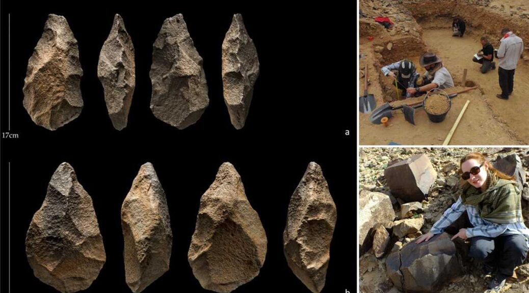
200,000-year-old tools from Stone Age unearthed in Saudi Arabia
A team of Saudi scientists from the Heritage Authority recently discovered stone tools used by the inhabitants of Assyrian civilization in the Paleolithic time period that date back to 200,000 years.
While exploring the site near Shuaib Al-Adgham in the Al-Qassim area, the Heritage Authority found a range of Neolithic tools: iron knives, scrapers, axes, and stone pierce tools from the Middle Paleolithic period.
These are unique and rare stone axes that were characterized by the high precision in manufacturing that these human groups used in their daily life.
The abundance of stone tools discovered from this site indicated the numerical density of prehistoric communities that lived in this region.
It is also a clear indication that the climatic conditions in the Arabian Peninsula were very suitable for these human groups as they benefited from the natural resources available therein.
The satellite images showed that the Shuaib Al-Adgham and other sites were connected with passages of rivers to confirm that humans used rivers to reach deep into the interior regions of the Arabian Peninsula in ancient times.
According to the wide spatial distribution of the Assyrian sites, they were the largest concentrations of human inhabitance worldwide.
It also indicates that human groups in the Arabian Peninsula were able to cross through vast swathes of geographical distances, while the large number of sites centered around ancient valleys and rivers indicated that these groups were gradually spreading and discovering new sites when they needed them.
These sites were characterized by the spread of broken stone fragments and manufactured tools.
The authority stated that a huge amount of new environmental and cultural information has been collected, and the results showed that there were significant changes in the environments, ranging from very arid to humid.
The current evidence strongly supports the assertions of the existence of the “Green Arabian Peninsula” many times in the past.
During the wet phases of human civilizations, there were rivers and lakes throughout the Arabian Peninsula, which led to the spread and expansion of these human groups.
This confirms that the Arabian Peninsula was a major crossroads between Africa and the rest of Asia throughout prehistoric times and that it was one of the places of settlement in the period of the Stone Ages.
It is believed that the ancient migrations of these human groups were through two main passages — the Bab Al-Mandab Strait and the Sinai Peninsula Corridor.
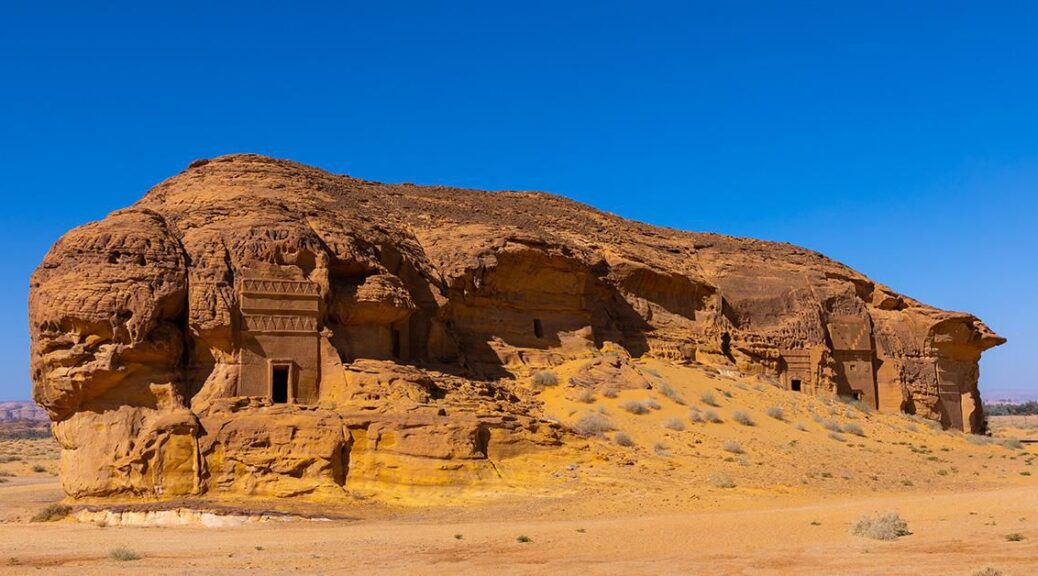
Saudi Arabia Opens Its First UNESCO World Heritage Site ‘Hegra’ After 2,000 Years
Saudi Arabia is now opening the ancient archaeological site – Hegra – for the public in order to promote historical sites. Hegra, which has been unchanged for nearly 2000 years, is the first UNESCO World Heritage site in the Kingdom.
This lesser-known sister city of Petra in Jordan was founded by the Nabateans, an ancient Arab people who inhabited northern Arabia and the southern Levant.
They had created a huge empire in the desert from the 4th century BC to the 1st century AD when Emperor Trajan conquered them and they became subjects of the Romans. These nomads controlled the spice trade, and later they built an astonishing civilization in the desert.
The Qasr al-Farid tomb (The Lonely Castle) carved into rose-colored sandstone in Hegra, also known as Madain Saleh, a UNESCO World Heritage site, near Saudi Arabia’s northwestern town of al-Ula.
Petra was rediscovered in the 19th century, however, the earliest historic location in the kingdom — Hegra — was left forgotten by all but the Bedouin until recent decades. But all that remains now of the city they built is some rock-cut tombs and relics.
Over 90 of the total 111 tombs recorded at the location are decorated. Many of the tombs have inscriptions, written in an early form of Arabic that “warn the living not to interfere with the tombs”, according to a report.
One inscription reads, “May the lord of the world curse upon anyone who disturbs this tomb or opens.” The site also features some 50 inscriptions of the pre-Nabataean period and some cave drawings.
According to UNESCO, the site “bears witness to the development of Nabataean agricultural techniques using a large number of artificial wells in the rocky ground”.
The challenge with getting to know the Nabataeans is that they left behind so little first-hand history.
The remains at Hegra show a lot of Roman influence as it was also once subjugated by the Romans. Despite the Roman subjugation, the city of Hegra continued to prosper until the 3rd century AD.
Ever since the city fell into decline, it had been left practically undisturbed for almost 2,000 years. It was abandoned by the Middle Ages, but the Ottomans built a fort at the site during World War 1 during the Arab revolt which was instigated by Lawrence of Arabia.
Earlier this year, Saudi Arabia’s tourism minister had said that the country could see a decline in the tourism sector this year due to measures taken by the government to fight the coronavirus pandemic.
Saudi Arabia is now determined to wean its economy off the petro pipeline.
It is a roadmap for the kingdom over the next two decades to transform into a global hub for trade and tourism that connects Africa, Asia, and Europe. Also, magnificent antiquities in Saudi Arabia are being promoted as must-do itineraries for travellers seeking undiscovered locations.
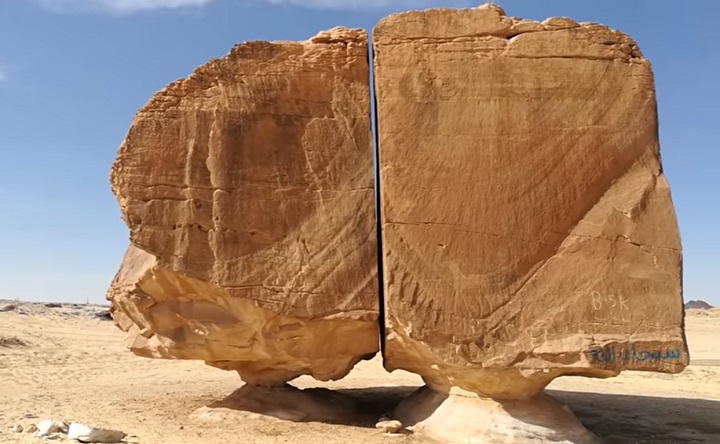
A massive 4,000-year-old monolith split with laser-like precision
Al Naslaa may look like nothing more than a massive rock to some, yet it is one of the most fascinating geological formations in history. The captivating formation is located far inside the Tayma Oasis in Saudi Arabia, where it has puzzled and entranced historians, geologists, and tourists for years. The formation features a huge piece of sandstone (with unique shaping on both sides) balanced on a naturally-formed pedestal. What makes the formation so unique? It’s split!
What makes the Al Naslaa formation famous
Al Naslaa is unique not only because of its shape, location, and age but also due to the precise break that separates one half of the formation from the other. While it may look like a simple crack in the foundation of the sandstone, the break is so exact and straight that it looks as if though someone took a laser to the rock to split it apart. In addition, the two remarkably heavy sides of the formation seem to balance on nothing more than thin pieces of rock, appearing to nearly gravitate in thin air.
In order to assess the nature of how the famed formation came to be, it’s important to recognize its history. The formation has existed since ancient times and has taken centuries to acquire its shape. Al Naslaa is only one of many rocks in the Tayma Oasis that features a unique appearance, as the limestone, shale, and sandstone there have spent centuries culturing into fantastic formations (with the help of a little rain and wind, of course).
Before these formations even developed into the stunning shapes they occupy today, the Tayma Oasis was occupied by everyone from Babylonian royalty to everyday traders on their route. They interacted with the landscapes in various ways, including writing and drawing on the rocks. In addition to its famed formation, Al Naslaa is fortunate enough to feature one of these petroglyphs on its surface: the figure of a horse.
Thanks to the ancient people who interacted with Al Naslaa (in addition to its geological history), we can tell that Al Naslaa has been a primary part of the Tayma Oasis for as long as the landscape has existed. But what does its shape—along with its iconic split—tell us about how the rock formation came into existence?
The scientific theories behind the formation
Across the years, historians have tried to understand the features that set Al Naslaa apart from the thousands of similar sandstone formations in the Saudi Arabian oasis. In addition to its split, one thing that is unique about Al Naslaa is the smoothness of the front of the rock, despite the round/jagged shaping on either side.
If you were to look at the rock from the side rather than the front, the smoothed-out surface concealing the famous crack might make it look as if though someone sanded the front-facing portion of the formation down. And technically, the elements have.
“The standing stones of Al Naslaa truly are a big mystery. Two stones split in half have created confusion among experts ever since their discovery.”
– Charismatic Planet, YouTube
Considering the nature of sandstone, the flat shaping on the front is unsurprising, as wind and rain have beaten away at the smooth sections of rock. However, natural elements can not explain the thin crack separating either side of the massive rock, or how they have managed to stay perfectly balanced on either of their thin platforms. What have scientists theorized about how the great divide came to be?
The likely cause of the split
According to geologists, the likely cause for the split is tectonic motion. The most likely natural cause of the formation is that the ground shifted ever-so-slightly beneath the supporting beam of one half of the rock, and it caused the rock to split into two. This is the most widely supported theory in the scientific world, though others have speculated at other natural (and unnatural) causes for the rock’s separation.
Other scientists theorize that the split is, in fact, a fault line, as the material surrounding faults tends to be weaker and erode more easily at the will of the elements. If this is the case, then the wind is likely what tore away at the weak material of the fault, leaving behind the near-solid remaining halves of the rock.
In addition, there is potential that the split is the result of a joint (fractures formed at weak points in rock formations) that may have been formed by a type of erosion, such as wind, water or ice.
“This rock formation is called Al Naslaa. The uniform slit between the two standing stones and the flat faces are completely natural. Most likely the ground shifted slightly underneath one of the two supports and the rock split. Could be from a volcanic dike of some weaker mineral that solidified there before everything was exhumed.”
– Hashem Al-Ghaili
However, there are still more theorists who believe that the formation is not a natural occurrence at all. Although scientific evidence backs up the idea that Al Naslaa was not man-made, the conflicting opinions of its formation—in addition to its perfect split—have caused some to turn to other sources of explanation…including the supernatural.
The rumours behind the ancient rock
In addition to the potential natural causes of Al Naslaa, many people—from scientists to conspiracy theorists—have other ideas about how the rock gained its unusual shape. One such theory? Aliens. Considering the formation looks as if though it was cut apart by a well-aimed laser, some believe that a U.F.O. descended into the Tayma Oasis and zapped the rock apart with advanced technology not available to humans at its formation.
While this is a more bizarre theory, plenty of people have put their chips into it, believing that the break between the two halves of the rock is too perfect to have been produced by erosion. In addition, there are others who feel that there is a potential that the ancient settlers of the civilization that first came into contact with Al Naslaa were the ones who managed to split the rock apart. Still, their theories about how they pulled this off might be even tougher to believe than the theory about aliens.
Those who feel that ancient civilizations pulled the rock apart don’t believe they did it by sheer man-power, a giant wire, or by tying either end of the rock to a camel carriage. Rather, they feel that there is the potential that advanced humans lived in the Tayma Oasis who were able to successfully craft, aim, and fire a laser to split the rock apart. Considering the precise nature of the crack, it’s understandable why people might feel that there is no way that nature is responsible for the break.
If the Flinstones met the Jetsons, the laser-theory may have been possible, yet most geologists and historians are highly doubtful that this possibility is well-founded. There is no charted technology of that caliber in ancient civilizations. However, with no one there to view the rock’s formation and discredit the more outlandish theories, the chance that the formation was created by superhumans, aliens, or robots remains up for debate.
The current life of Al Naslaa
Today, Al Naslaa is not only a marvel in the scientific community, but is beloved by those who come to visit the formation. People travel from around the world to witness the fascinating and mysterious bit of landscape. Fortunately, the historical rock is open for all to see, touch, and photograph. Reaching the landmark by car on the dirt road is the best route, though some choose to park further back and walk partially through the desert-land to explore other elements of the landscape.
“Sometimes you’ve just got to take a moment out of your day to gaze at an inexplicable petroglyph located in Tayma – about an eight-hour drive out of Riyadh, Saudi Arabia. Take a little time to take in two rocks poised on insubstantial plinths, separated by a thin, perfectly vertical gap.
Appreciate the empty divide. Perfect, as if the rock were geologic Gruyère de Comté to which the [A]lmighty took a wire cheese slicer.”
– smith journal
Al Naslaa is not only relevant in historical and scientific circles, but remains a love of many tourists, photographers, and conspiracy theorists worldwide. The photogenic rock that seems to defy all logic continues to mystify those in academic/scientific circles and those beyond it, all of whom are fascinated by the shape, structure, and appearance of the iconic stone.
While we may never know the true root of the formation’s centuries-long shaping—and the rock is still being shaped in real-time by erosion—the debate doesn’t influence the fact that the fascination and intrigue surrounding the formation will never die down.