Eerie ‘yellow brick road’ to Atlantis was discovered atop an ancient undersea mountain
A team of marine biologists realized they definitely weren’t in Kansas anymore after discovering what appeared to be a yellow brick road on top of an undersea mountain near Hawaii.
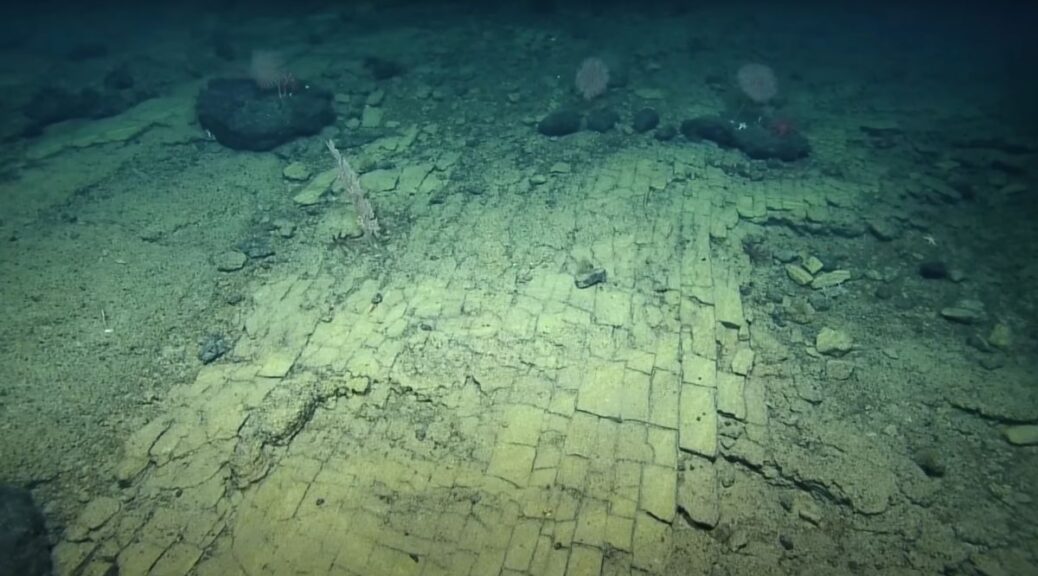
“The yellow brick road?” a scientist mused in a YouTube video of the discovery.
Others remarked that the rocks were reminiscent of a very different fictional world: “It’s the road to Atlantis,” one researcher said.
The yellow rocks, divided from each other at neat 90-degree angles, form a narrow strip and look like they were carved and arranged by human hands. However, the seemingly paved roadway was simply the natural result of ancient volcanic activity thousands of feet below the water’s surface, the researchers said in a description below the video.
“At the summit of Nootka Seamount, the team spotted a ‘dried lake bed’ formation, now IDed as a fractured flow of hyaloclastite rock (a volcanic rock formed in high-energy eruptions where many rock fragments settle to the seabed),” the researchers wrote.

The remarkably brick-like divisions between the rocks are likely the coincidental result of heating and cooling stresses from multiple volcanic eruptions over millions of years, the team added.
The researchers took a detour down this eerie undersea road while piloting a remotely operated vehicle (ROV) around the Papahānaumokuakea Marine National Monument, a protected conservation area encompassing about 582,578 square miles (1,508,870 square kilometres) of the Pacific Ocean northwest of Hawaii.
The expedition is part of the Ocean Exploration Trust’s Nautilus Exploration Program and aims to investigate the ancient seamounts near Liliʻuokalani Ridge, at the monument’s western edge.
One of the team’s main goals is to collect geological samples from the area’s seamounts — underwater mountains formed by volcanic activity — to better understand their ages and origins.
Learning this may also yield new insights into the formation of the Hawaiian Islands, the researchers wrote on the Nautilus website. The team will also collect microbial samples, to study what kinds of oddball organisms have managed to thrive near the deep, underwater volcanoes of the Pacific.
“Our exploration of this never-before-surveyed area is helping researchers take a deeper look at life on and within the rocky slopes of these deep, ancient seamounts,” the researchers added.
Previous expeditions aboard the Nautilus research vessel have turned up plenty of unnerving marine oddities. During a 2018 excursion to the Papahānaumokuakea Marine National Monument, researchers were dumbfounded by a wriggling, googly-eyed creature that seemed to change shape while in front of the camera.
Researchers later identified the creature as a gulper eel (Eurypharynx pelecanoides), an incredibly big-mouthed fish that can unhinge its massive jaw to swallow prey even larger than itself.
The researchers controlling the ROV during that expedition also responded to the strange sight before them with a cultural reference.
“Looks like a Muppet,” one researcher said.