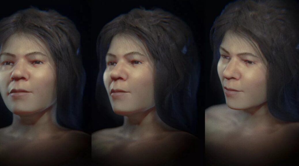
See the striking facial reconstruction of a Paleolithic woman who lived 31,000 years ago

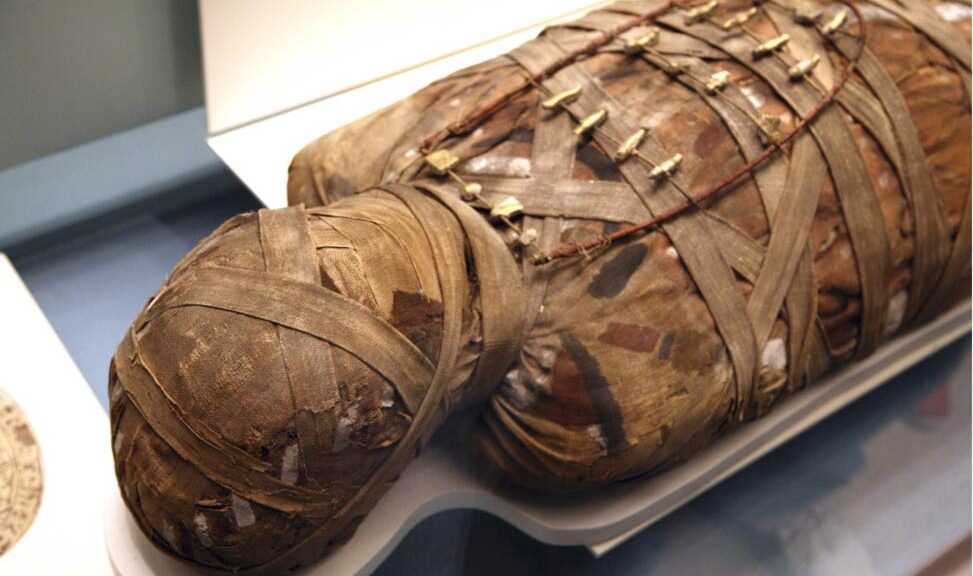
In 1881, archaeologists unearthed the skull of a human buried inside a cave in Mladeč, a village in what is now the Czech Republic. At the time, researchers dated the skull to about 31,000 years ago and classified the individual as male.
But they were wrong about the Stone Age person’s sex, a new study finds.
Now, more than 140 years later, researchers have corrected that error, revealing that the so-called Mladeč 1 skull belonged to a 17-year-old female who lived during the Aurignacian, part of the Upper Paleolithic period (roughly 43,000 to 26,000 years ago).
The team published its findings as part of a new online book called “The Forensic Facial Approach to the Skull Mladeč 1(opens in new tab)” that details how the scientists reclassified the sex of “one of the oldest Homo sapiens found in Europe.”
“When the skull was analyzed individually, the features pointed to a male,” Cicero Moraes, a Brazilian graphics expert and one of the book’s co-authors, told Live Science in an email. “But when later studies compared the skull with others found at the site, the evidence pointed to a female.”
Using information collected from the 19th-century archaeological dig, as well as forensic facial reconstructions performed by researchers in the 1930s that were limited due to a lack of technology, Moraes and co-authors Jiří Šindelář, a surveyor with a local surveying company GEO-CZ, and Karel Drbal, deputy director of the Cave Administration of the Czech Republic, used CT (computer tomography) scans to create a digitized approximation of the skull. Because the mandible (lower jaw) was missing, Moraes looked to existing data of modern-day human jaws to help fill in the blanks of what this individual might have looked like.
“We had to reconstruct the skull and for that, we used statistical data of average and projections extracted from about 200 CT scans of modern humans and from archaeological excavations belonging to different population groups, including Europeans, Africans and Asians,” Moraes said. “[This] allowed us to project missing regions of the human face.”
Once they had a complete digital image of the skull, Moraes used “a series of soft-tissue thickness markers that were spread across it,” he said. “These markers, roughly speaking, tell the boundaries of the skin in some regions of the face.
Although these markers come from statistical data extracted from living individuals, they do not cover the entire face and do not inform the size of the nose, mouth and eyes, for example.”

To help complement the data, researchers “imported CT scans of live subjects and deformed the bones and soft tissue from the CT scan to match the face being approximated,” he said. “In the case of the Mladeč 1 fossil, we deformed two CT scans, one of a man and one of a woman, and the two converged to a very similar result.”
For the book, Moraes created two digital approximations of what the individual might have looked like. But he erred on the side of caution when it came to the person’s facial expression.
“We chose to generate the neutral face by tradition, as we are used to presenting works to specialists,” he said. “The trend will now be to present two approaches to the works, one more scientific and simple in greyscale, with eyes closed and without hair, and the other more subjective…where we generate a coloured face with fur and hair.”
While it’s not very common for archaeologists to reclassify the sex of human remains, it does happen. Moraes pointed to one such example, a skeleton discovered in Brazil known as the “Zuzu(opens in new tab)” fossil.
“That case was different; initially it was thought to be a woman, but later studies revealed [it] was actually a male,” he said.
In another case, a Viking buried with weapons in Sweden was originally thought to be male but was later revealed to be female, Live Science previously reported.
In addition to the skull, other items found at the Stone Age burial site during the original dig included stone artifacts, bone tips and several teeth. However, little else is known about the young woman who was buried there.