World’s Oldest Psychiatric Hospital Revealed in Turkey’s Cappadocia
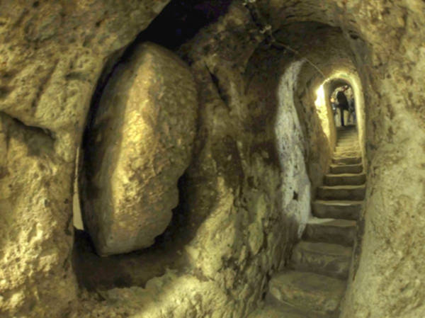
Deep beneath the surreal landscapes of Cappadocia, archaeologists and local authorities have announced the restoration of what they believe to be humanity’s earliest known mental health facility.
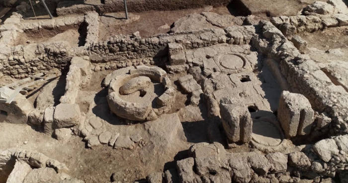
The Aya Maryeros Underground Monastery in Derinkuyu, dating back to the 4th century AD, served dual purposes as both a religious sanctuary and a pioneering psychiatric treatment center during the Byzantine era. This extraordinary discovery promises to revolutionize our understanding of ancient medical practices and mental health care in the early Christian world.
Located in the Cumhuriyet district of Derinkuyu, Nevsehir province, this underground complex was initially identified in the 1990s beneath a neglected building that had been used as a waste site for decades.
The Derinkuyu District Governor’s Office and municipality have now launched an ambitious restoration project to transform the site into a museum, recognizing its profound historical significance.
According to Türkiye Today, the complex features the characteristic tunnels, living quarters, storage rooms, and rock-carved galleries that define Cappadocia’s famous underground cities.
Revolutionary Medical Practices in Ancient Times
Derinkuyu Mayor, Taner Ince, emphasized the site’s unprecedented historical importance, describing it as “the world’s oldest and first mental hospital” where Christian clerics provided care for individuals suffering from psychological conditions.
This assertion, if confirmed through further archaeological investigation, would predate other known ancient medical facilities by centuries. The monastery operated during a crucial period when early Christianity was establishing new approaches to caring for society’s most vulnerable members.
According to historical accounts researched by the Anatolian Archaeology Network, Byzantine medical practitioners at the monastery employed innovative therapeutic methods that combined spiritual care with practical treatment approaches.
These included music therapy, physical rehabilitation, and comprehensive spiritual support – techniques that bear remarkable similarities to modern holistic mental health treatment program.
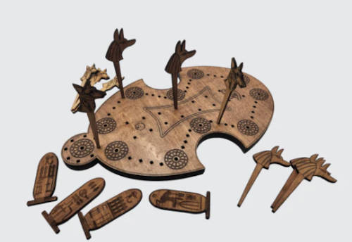
Dogs and Jackals Boardgame: The Pharaoh’s Favorite, from the AO store.
Archaeological Significance and Restoration Challenges
Historian Eray Karaketir, who has extensively studied Cappadocia’s underground settlements, explained that Aya Maryeros forms part of a vast network of subterranean communities carved into the region’s distinctive volcanic rock formations.
These underground cities were constructed by early Christians fleeing persecution in the Eastern Roman Empire, serving as secure refuges during times of religious and political upheaval.
The monastery lies approximately 10 to 15 meters (33-49 ft) underground and was specifically renowned for serving individuals with mental health conditions.
Karaketir noted that centuries of looting had significantly damaged the structure, with wooden doors destroyed and supporting columns compromised.
The current restoration effort focuses on structural stabilization, installation of permanent lighting systems, and eventual reopening of blocked tunnels that may connect to the vast Derinkuyu Underground City network.
The extensive underground city network of Derinkuyu in Cappadocia
Future Plans for Cultural Tourism
The restoration project represents a significant investment in Cappadocia’s already thriving cultural tourism industry. Officials believe the completed museum will provide visitors with unique insights into both religious and medical history, complementing the region’s existing attractions such as the famous Derinkuyu Underground City, which could accommodate up to 20,000 residents.
The discovery adds another layer to Turkey’s rich archaeological heritage and demonstrates the sophisticated understanding of mental health care that existed in ancient civilizations.
As restoration work continues, scholars anticipate that Aya Maryeros will become a crucial site for understanding the intersection of religion, medicine, and social welfare in the Byzantine world.
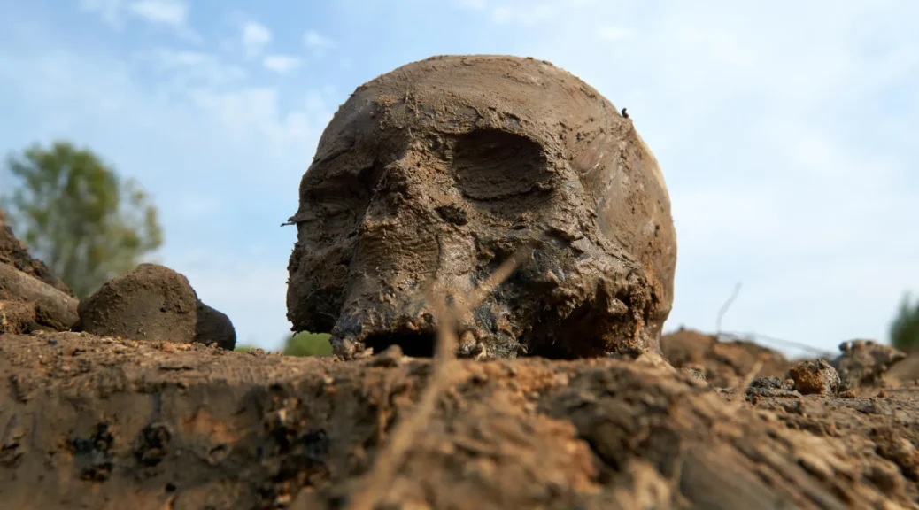
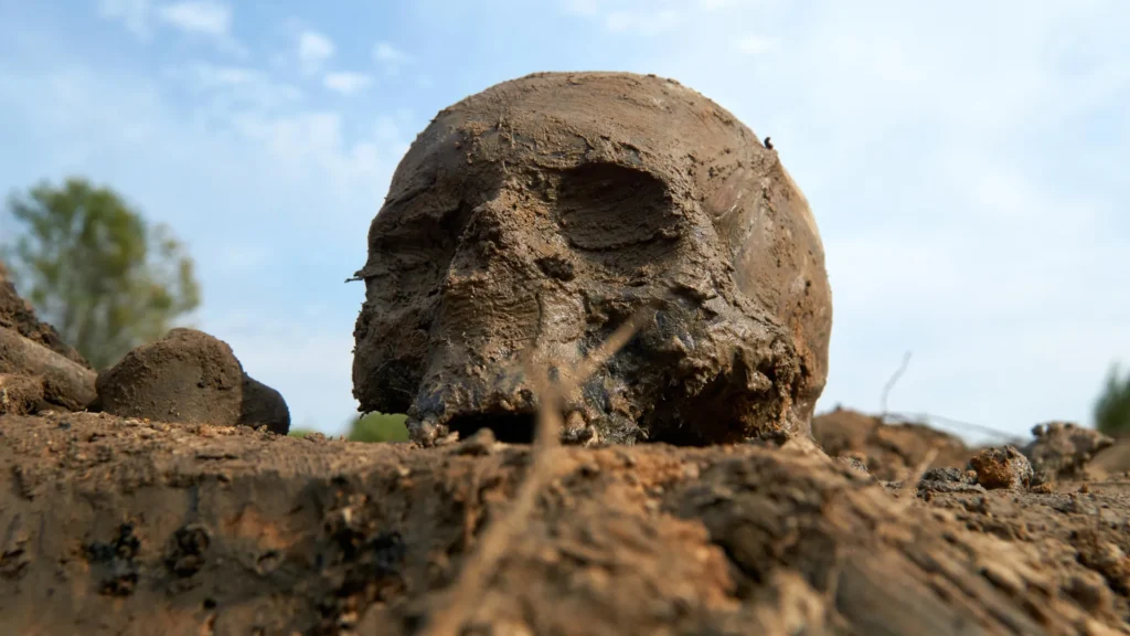
History’s first pandemic: Ancient DNA solves mystery of what caused 1,500-year-old epidemic
Archaeologists and geneticists identified plague DNA in 1,500-year-old teeth from Jerash, Jordan, providing the first direct proof that the Justinian Plague was caused by Yersinia pestis.
For the first time, researchers have uncovered direct genomic evidence of the bacterium behind the Plague of Justinian — the world’s first recorded pandemic — in the Eastern Mediterranean, where the outbreak was first described nearly 1,500 years ago.
The landmark discovery, led by an interdisciplinary team at the University of South Florida and Florida Atlantic University, with collaborators in India and Australia, identified Yersinia pestis, the microbe that causes plague, in a mass grave at the ancient city of Jerash, Jordan, near the pandemic’s epicenter. The groundbreaking find definitively links the pathogen to the Justinian Plague marking the first pandemic (AD 541-750), resolving one of history’s long-standing mysteries.
For centuries, historians have deliberated on what caused the devastating outbreak that killed tens of millions, reshaped the Byzantine Empire and altered the course of Western civilization. Despite circumstantial evidence, direct proof of the responsible microbe had remained elusive — a missing link in the story of pandemics.
Two newly published papers led by USF and FAU provide these long-sought answers, offering new insight into one of the most consequential episodes in human history. The discovery also underscores plague’s ongoing relevance today: while rare, Y. pestis continues to circulate worldwide. In July, a resident of northern Arizona died from pneumonic plague, the most lethal form of Y. pestis infection, marking the first such fatality in the U.S. since 2007, and just last week another individual in California tested positive for the disease.
“This discovery provides the long-sought definitive proof of Y. pestis at the epicenter of the Plague of Justinian,” said Rays H. Y. Jiang, PhD, lead PI of the studies and associate professor with the USF College of Public Health. “For centuries, we’ve relied on written accounts describing a devastating disease, but lacked any hard biological evidence of plague’s presence. Our findings provide the missing piece of that puzzle, offering the first direct genetic window into how this pandemic unfolded at the heart of the empire.”
The Plague of Justinian first appeared in the historical record in Pelusium (present day Tell el-Farama) in Egypt before spreading throughout the Eastern Roman, or Byzantine, Empire. While traces of Y. pestis had previously been recovered thousands of miles away in small western European villages, no evidence had ever been found within the empire itself or near the heart of the pandemic.
“Using targeted ancient DNA techniques, we successfully recovered and sequenced genetic material from eight human teeth excavated from burial chambers beneath the former Roman hippodrome in Jerash, a city just 200 miles from ancient Pelusium” said Greg O’Corry-Crowe, PhD, co-author and a research professor at FAU Harbor Branch Oceanographic Institute and a National Geographic Explorer.
The arena had been repurposed as a mass grave during the mid-sixth to early seventh century, when written accounts describe a sudden wave of mortality.
Genomic analysis revealed that the plague victims carried nearly identical strains of Y. pestis, confirming for the first time that the bacterium was present within the Byzantine Empire between AD 550-660. That genetic uniformity suggests a rapid, devastating outbreak consistent with historical descriptions of a plague causing mass death.
The plague of the Philistines at Ashdod by Pieter van Halen, which is described in the Old Testament, I Samuel 5, 5-6. (Peter van Halen / CC BY 4.0)
“The Jerash site offers a rare glimpse of how ancient societies responded to public health disaster,” said Jiang. “Jerash was one of the key cities of the Eastern Roman Empire, a documented trade hub with magnificent structures. That a venue once built for entertainment and civic pride became a mass cemetery in a time of emergency shows how urban centers were very likely overwhelmed.”
A companion study, also led by USF and FAU, places the Jerash discovery into a wider evolutionary context. By analyzing hundreds of ancient and modern Y. pestis genomes — including those newly recovered from Jerash — the researchers showed that the bacteria had been circulating among human populations for millennia before the Justinian outbreak.
The team also found that later plague pandemics, from the Black Death of the 14th century to cases still appearing today, did not descend from a single ancestral strain. Instead, they arose independently and repeatedly from longstanding animal reservoirs, erupting in multiple waves across different regions and eras. This repeated pattern stands in stark contrast to the SARS-CoV-2 pandemic (COVID-19), which originated from a single spillover event and evolved primarily through human-to-human transmission.
Together, the landmark findings reshape the understanding of how pandemics emerge, recur and spread, and why they remain a persistent feature of human civilization. The research underscores that pandemics are not singular historical catastrophes, but repeating biological events driven by human congregation, mobility and environmental change — themes that remain relevant today.
“This research was both scientifically compelling and personally resonant. It offered an extraordinary opportunity to delve into the study of human history through the lens of ancient DNA at a time when we ourselves were living through a global pandemic,” said O’Corry-Crowe. “Equally profound was the experience of working with ancient human remains — individuals who lived, suffered, and died centuries ago — and using modern science to help recover and share their stories. It’s a humbling reminder of our shared humanity across time and a moving testament to the power of science to give voice to those long silent.”
While very different from COVID-19, both diseases highlight the enduring link between connectivity and pandemic risk, as well as the reality that some pathogens can never be fully eradicated.
“We’ve been wrestling with plague for a few thousand years and people still die from it today,” Jiang said. “Like COVID, it continues to evolve, and containment measures evidently can’t get rid of it. We have to be careful, but the threat will never go away.”
Building on the Jerash breakthrough, the team is now expanding its research to Venice, Italy and the Lazaretto Vecchio, a dedicated quarantine island and one the world’s most significant plague burial sites. More than 1,200 samples from this Black Death-era mass grave are now housed at USF, offering an unprecedented opportunity to study how early public health measures intersected with pathogen evolution, urban vulnerability and cultural memory.
Early Humans Defied Britain’s Harshest Ice Age 440,000 Years Ago
Archaeological breakthrough at Canterbury reveals Homo heidelbergensis survived the brutal Anglian glaciation, rewriting assumptions about early human resilience and adaptation in prehistoric Europe.
A revolutionary archaeological discovery has shattered long-held beliefs about early human survival during Ice Age Britain. Excavations at Old Park, Canterbury, have uncovered compelling evidence that Homo heidelbergensis not only inhabited Britain over 700,000 years ago but remarkably survived one of northern Europe’s most extreme ice ages around 440,000 years ago.
The research, published in Nature Ecology and Evolution by archaeologists from the University of Cambridge, presents the first concrete proof that early humans could endure the harsh conditions of the Anglian glaciation – a discovery that fundamentally challenges previous assumptions about human adaptability in prehistoric Europe.
Unprecedented Archaeological Evidence from Canterbury
The excavation site at Old Park, strategically positioned on the banks of the River Stour in Canterbury, Kent, has yielded thousands of Paleolithic stone tools attributed to Homo heidelbergensis, an early human species regarded as an ancestor of Neanderthals. While stone tools had been discovered at this location since the 1920s, fresh excavations launched in 2020 revealed sediments far older than previously imagined.
“Old Park is unique in the UK as it retains these exceptionally high, and therefore old, artifact retaining gravels,” explains Dr. Alastair Key from the Department of Archaeology at the University of Cambridge. “It is the fact we can excavate these sediments that’s so important. This isn’t possible at earlier archaeological occurrences in the UK, as they are located in cliffs or are buried too deeply.”
The stone tools discovered in the deepest layers date from between 712,000 and 621,000 years ago, representing some of the earliest evidence of human occupation in Britain. However, the most startling discovery emerged from layers dating to the Anglian glaciation period, when sharp flint tools were found sealed between river gravels and sands approximately 440,000 years old.
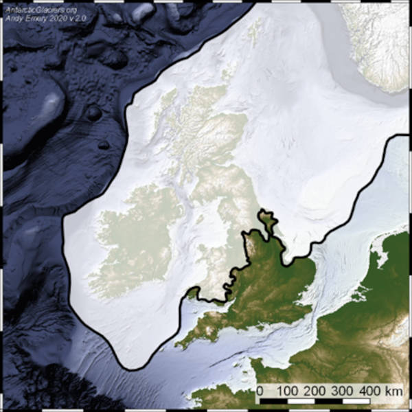
Map showing the extent of the British-Irish Ice Sheet during the Last Glacial Maximum. (Bathymetry data are from the GEBCO 2016 dataset.
Surviving the Anglian Glaciation
The Anglian glaciation, occurring approximately 450,000 years ago, represents one of the most severe ice ages in northern European history. During this period, massive ice sheets extended across much of Britain, creating an environment so hostile that scientists previously believed human survival would have been impossible.
“The clearest explanation is that these humans were making flint tools directly on top of the gravel during this ice age, and that these tools were then quickly covered before their edges abraded and broke,” said Dr. James Clark, co-author of the study.
The preservation quality of these flint tools provides crucial evidence for their contemporaneous manufacture during the glacial period. Had the tools been created earlier and subsequently moved by glacial action, they would have shown significant wear and damage from transportation and exposure. Instead, the sharp, unworn edges indicate they were crafted and immediately buried, preserving them in pristine condition.
This discovery represents a paradigm shift in understanding early human capabilities. The ability to survive such extreme climatic conditions demonstrates remarkable adaptability, technological sophistication, and environmental knowledge among these ancient populations.
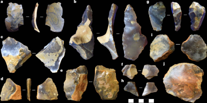
A selection of flake artifacts from Old Park.
Revolutionary Understanding of Human Adaptability
“This is exciting because it was previously assumed to be impossible for humans to survive in Britain during these cold phases, meaning the evidence is testament to the adaptability of these very early populations,” added Dr. Clark.
The implications of this discovery extend far beyond British archaeology. It suggests that early human populations possessed sophisticated survival strategies, including advanced tool-making techniques, shelter construction capabilities, and possibly complex social organization necessary for surviving extreme environmental conditions.
Homo heidelbergensis, known for having brain sizes approaching those of modern humans, demonstrated remarkable technological innovation. These early humans were among the first to build substantial shelters, create complex tool assemblages, and develop hunting strategies capable of sustaining communities through harsh climatic periods.
The Canterbury evidence also provides insights into early human migration patterns and settlement strategies. Rather than simply following favorable climates, these populations actively adapted to challenging environments, suggesting a level of cognitive flexibility previously unrecognized in early human species.
Implications for Early Human Evolution
The Canterbury discoveries provide unprecedented insights into the cognitive and technological capabilities of Homo heidelbergensis. The ability to survive the Anglian glaciation required sophisticated understanding of seasonal patterns, resource management, and technological innovation – capabilities that suggest these early humans possessed far more advanced cognitive abilities than previously recognized.
The preservation of these archaeological layers also offers a unique window into early human behavior during extreme climatic stress. The immediate burial of freshly-made tools suggests rapid environmental changes that could preserve archaeological evidence, providing researchers with exceptional detail about ancient human activities.
Furthermore, this evidence suggests that human occupation of Britain was not intermittent but potentially continuous through even the most challenging climatic periods. This fundamentally alters our understanding of early human dispersal patterns and settlement strategies across northern Europe.
Broader Context of Ice Age Survival
The Canterbury evidence places early British populations within a broader context of human adaptation to Ice Age conditions across Europe. While previous research had documented human survival in more temperate regions during glacial periods, the British evidence represents some of the northernmost proof of human persistence through severe glaciation.
This discovery also highlights the importance of river valley environments as refugia during harsh climatic periods. The River Stour valley would have provided essential resources including water, shelter from winds, and access to diverse plant and animal resources necessary for survival.
The research team’s methodological approach, combining traditional excavation techniques with advanced dating methods and detailed stratigraphic analysis, has established new standards for investigating early human occupation sites. Their ability to precisely date archaeological layers and correlate them with climatic records provides unprecedented resolution in understanding early human-environment interactions.
The study’s implications extend to modern discussions about human adaptability and climate change. The evidence from Canterbury demonstrates that even with relatively simple technology, early human populations could adapt to dramatic environmental challenges through innovation, cooperation, and strategic resource management.
As climate research continues to reveal the severity of past glacial periods, the Canterbury evidence becomes even more remarkable. These early humans not only survived but maintained sophisticated tool-making traditions through environmental conditions that would challenge even modern survival capabilities.
The ongoing excavations at Old Park promise to yield additional insights into early human life during Ice Age Britain. As researchers continue to analyze the thousands of artifacts and associated environmental evidence, our understanding of human adaptability and technological innovation will undoubtedly continue to evolve.
2,000-year-old Roman bridge discovered in Switzerland
Archaeological teams in Switzerland have uncovered the remains of a remarkable Roman wooden bridge that served as a crucial transportation link for over four centuries.
The discovery in Aegerten, near Biel, reveals sophisticated engineering techniques that highlight the Romans’ mastery of infrastructure development across their vast empire.
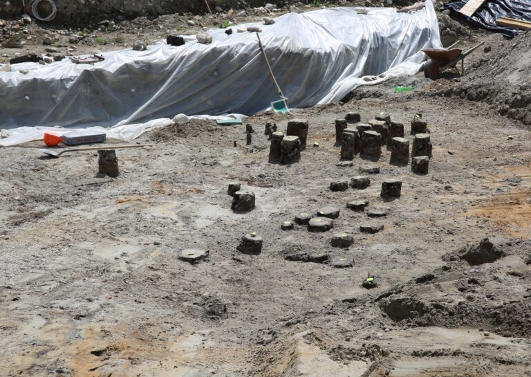
More than 300 well-preserved oak piles emerged during construction work, providing archaeologists with a treasure trove of information about Roman engineering capabilities.
The wooden posts, protected by groundwater conditions, offer unprecedented insights into bridge construction techniques used throughout the Roman Empire.
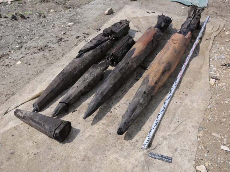
Excavation showing closely spaced oak posts from the bridge spans. A sample was taken from each individual post for age determination.
Dendrochronology Reveals Bridge Timeline
Advanced tree-ring analysis conducted at the Archaeological Service’s dendrology laboratory provided precise dating for the bridge construction phases.
The earliest components date to approximately 40 BC, shortly after the Roman conquest of the Celtic Helvetii tribe, according to the Bern Canton Archaeological Service.
The youngest elements were constructed in 369 AD during Emperor Valentinian’s reign, when Roman military forces strengthened defenses behind the Rhine frontier.
This extended timeline demonstrates the bridge’s strategic importance and the Romans’ commitment to maintaining critical infrastructure. Bridge piers underwent multiple repairs and reconstructions throughout the centuries, reflecting standard Roman maintenance practices that ensured long-term structural integrity.
Strategic Location Along Ancient Trade Routes
The bridge stood at the entrance to Petinesca (modern Studen), a significant crossroads connecting major waterways and land routes across the Swiss Plateau.
This location provided access to the three Jura lakes and connected the region’s largest settlements through the Aare and Zihl rivers. A major road linking the Helvetic capital of Avenches/Aventicum with eastern territories passed through this area.
The newly discovered bridge formed part of the crucial Jura transversal route, branching off toward Augst/Augusta Raurica through the Taubenloch gorge near Biel.
This transportation network exemplified Roman strategic planning, connecting military installations with civilian settlements and facilitating trade across challenging terrain.
Exceptional Artifact Preservation
The waterlogged conditions beneath the former Zihl River created an exceptional preservation environment for organic materials. Archaeological teams recovered numerous metal objects from the river sediment, including shoe nails, horseshoes, yokes, axes, fishing tridents, keys, and coins that had fallen or been deliberately thrown from the bridge.
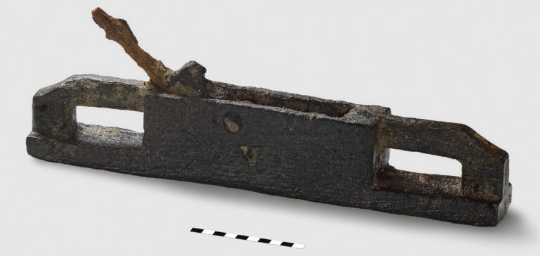
The most remarkable discovery was a complete wooden plane with an iron blade, measuring 41 centimeters long, 7 centimeters wide, and 5 centimeters high. Such tools rarely survive in archaeological contexts due to wood decay, making this find particularly significant for understanding Roman craftsmanship and daily life activities.
The fully preserved plane is made from a single piece of wood and features an inset iron blade. It is 41 cm long, 7 cm wide, and 5 cm high.
Roman bridge construction typically employed sophisticated foundation systems using wooden pilings driven deep into riverbed sediments. The oak posts discovered at Aegerten demonstrate the Romans’ preference for durable hardwood species that could withstand decades of water exposure and structural stress.
This construction method spread throughout the empire, with similar techniques documented from Britain to the Middle East.
The Swiss discovery adds valuable data to our understanding of Roman provincial infrastructure development. Unlike the monumental stone bridges that dominated urban centers, wooden structures served rural areas and provided flexible solutions for challenging geographical conditions.
These bridges required regular maintenance but offered cost-effective transportation links that supported economic growth and military logistics across frontier regions.
1,600-Year-Old Byzantine-Era Samaritan Villa Discovered in Central Israel
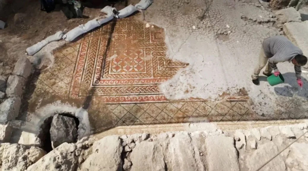
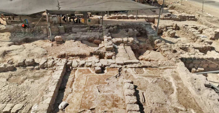
Archaeologists in Israel have unveiled one of the most significant Samaritan archaeological discoveries in recent years – a sprawling 1,600-year-old agricultural estate in Kafr Qasim that offers unprecedented insights into the prosperity and resilience of the ancient Samaritan community during the Byzantine period.
The remarkable excavation, conducted by the Israel Antiquities Authority (IAA) ahead of new housing construction, has revealed magnificent mosaics, ritual baths, and agricultural installations that showcase the wealth and cultural identity of this often-overlooked religious minority from antiquity.
Overview of one of the buildings at the Samaritan agricultural estate.
Magnificent Mosaics Display Wealth and Artistry
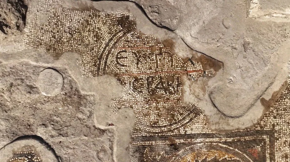
The estate’s centerpiece is a stunning mosaic floor featuring intricate geometric patterns, delicate acanthus leaves, and remarkably detailed depictions of fruits and vegetables including grapes, dates, watermelons, artichokes, and asparagus. At the entrance to the main room, excavators discovered a partial Greek inscription reading “Congratulations to,” followed by what appears to be a Samaritan name.
“The size and splendor of the buildings discovered, the quality of their mosaic floors, and the impressive agricultural installations all point to the great wealth and prosperity of the local Samaritan community,” explained excavation directors Alla Nagorsky and Dr. Daniel Leahy Griswold. The mosaics notably follow Samaritan religious traditions by avoiding any depictions of people, animals, or religious symbols, instead relying on elaborate geometric and botanical motifs.
Mazal Tov – Congratilations, or Good Luck! The inscription on one of the mosaics.
Ritual Purity and Agricultural Innovation
The northern section of the estate revealed sophisticated agricultural infrastructure including an olive press designed for ritual purity production, a large warehouse, and a mikveh (ritual purification bath). The proximity of the press to the ritual bath indicates the community’s commitment to producing olive oil according to strict religious requirements.
Area for olive oil production.
Most intriguingly, archaeologists uncovered what they term a “peripheral mikveh” – a unique ritual bath design with steps running along the entire perimeter rather than just one side. Dr. Leahy Griswold noted that while such baths were common during the Second Temple period (586 BC–70 AD), none had previously been documented from the Byzantine era, making this example especially significant.
A purification bath (miqveh) discovered in the excavation, used by the Samaritan community to produce olive oil in ritually pure conditions.
Surviving Through Turbulent Times
The estate operated for approximately 400 years, from the late Roman through the Byzantine period (fourth–seventh centuries AD), spanning some of the most challenging times in Samaritan history.
During the fifth and sixth centuries, the Samaritan community launched several unsuccessful revolts against Byzantine rule, which were brutally suppressed and resulted in significant population decline.
Archaeological evidence suggests the estate weathered these upheavals through adaptation. Luxurious residential buildings were later repurposed for purely agricultural use, with new walls subdividing rooms and older decorated elements being reused in later construction phases.
Despite these changes, the site maintained its distinctly Samaritan character, evidenced by the discovery of dozens of characteristic Samaritan oil lamps featuring knob handles and geometric designs.
Historical Significance and Ongoing Mysteries
The estate lies near the ancient village of Kafr Ḥatta, historically identified as Capparetaea – the birthplace of Menander, a first-century Samaritan magician and successor to Simon Magus, a figure mentioned in the New Testament. This connection adds another layer of historical significance to an already remarkable archaeological site.
Several mysteries remain unsolved, including the unusual use of Greek rather than the typical Samaritan Aramaic in the mosaic inscription, and the discovery of a rare glass spoon among the artifacts. The archaeologists also found evidence of what may be two distinct ritual pools, though further analysis is needed to determine their specific functions.
Dr. Leahy Griswold emphasized the site’s broader significance:
“We are talking about the largest Samaritan site outside of the Samaritan homeland. This site displays the historical gamut between prosperity and decline of the Samaritan community.”
The IAA plans to carefully preserve the mosaics and ritual baths while allowing continued development of the area, ensuring that both the historical legacy and modern needs of Kafr Qasim are honored.
Archaeologists Uncover 1,100-Year-Old Viking Boat Grave of Woman and Her Dog on Senja Island, Norway
In a remarkable archaeological discovery on Norway’s remote Senja Island, experts have unearthed a remarkably well-preserved 1,100-year-old Viking boat grave belonging to a woman of notable local status — and her loyal canine companion.
The find, revealed by archaeologists from the Arctic University Museum of Norway, was sparked by the chance encounter of metal detectorists, who discovered a pair of bronze bowl-shaped brooches and exposed rib bones beneath a thin layer of soil. Their discovery prompted a full excavation in May 2025, leading to a rare and intimate glimpse into Viking burial customs.
A Viking Burial of Significance
The wooden burial boat, measuring approximately 5.4 meters (18 feet) in length, was built mostly without iron rivets and lay just beneath the surface. Inside, archaeologists found the remains of a woman, laid on her side with knees bent, and at her feet — the skeleton of a small dog, possibly her pet.
“The dog appears to have been placed with great care,” said archaeologist Anja Roth Niemi in an interview with Science Norway. “While dogs in graves aren’t unheard of, their presence is still relatively rare. This one adds a deeply personal touch to the burial.”
A ring-shaped pendant was discovered near the skull, possibly once attached to an earring or decorative headpiece.
The dog’s inclusion may reflect emotional bonds between humans and animals even during the Viking Age. Saga literature and other sources suggest that Vikings deeply valued their dogs, sometimes taking extraordinary measures to care for them in life — and honoring them in death.
The woman was buried with a variety of artifacts that indicate her elevated social standing. These included:
Two ornate oval brooches adorned with silver thread
A bronze pendant and beads made from amber or bone
A sickle and whetstone, tools linked to agriculture
A whale bone object, likely a weaving sword used in textile production
The small dog was carefully placed at the feet of the deceased. While the exact breed may remain unknown, archaeologists believe they can still determine its general type.
“These items suggest she was of significant importance within her community — perhaps not at the very top of Viking society, but clearly someone of influence,” Niemi explained.
Preservation and Future Analysis
Despite the passage of over a millennium, parts of the skeleton were surprisingly well preserved, especially where metal artifacts helped prevent bacterial decay.
The northern Norwegian soil, rich in lime from ancient shell sand, contributes to the exceptional conservation of skeletal material.
Further laboratory analysis will confirm the sex, age, and health of the individual, as well as offer insights into her diet, physical condition, and life history. Advanced techniques might eventually even reconstruct her appearance.
One of the two oval brooches, still undergoing conservation.
Fragments of textiles and organic matter, preserved thanks to the careful work of the original metal detectorists, also promise to reveal more about Viking-era clothing and burial rituals.
A Site with More Secrets
Interestingly, archaeologists discovered another brooch just meters from the main grave, suggesting the potential existence of additional Viking burials nearby. Plans are underway to survey the site with ground-penetrating radar to uncover possible extensions of this ancient burial ground.
Boat burials are known from Viking culture, but intact graves with both human and animal remains are rare. “This discovery is significant not just for what it tells us about one woman’s life, but about the burial practices and social structure of Viking Age Northern Norway,” said Håkon Reiersen of the University of Stavanger.
The presence of the dog, the well-preserved bones, and the rich array of grave goods together paint a vivid picture of personal identity, status, and companionship in Viking society.
The Artificial Intelligence Revolution: The Dark Age of Ancient Scrolls Ends
Artificial intelligence, often envisioned for future applications, is now playing a pivotal role in unraveling the mysteries of the past. Researchers at the University of Oxford have achieved a groundbreaking feat by employing AI to decipher an ancient papyrus scroll that has perplexed scholars for over 250 years.
This remarkable achievement marks a significant leap forward in archaeology, demonstrating the powerful synergy between modern technology and the study of ancient civilizations.
While AI has already revolutionized fields like medicine and astronomy, its integration into archaeology has been relatively nascent. However, this is rapidly changing, as AI proves to be an invaluable tool in historical discoveries.
The recent breakthrough at the University of Oxford’s Bodleian Library, in collaboration with the Vesuvius Challenge, exemplifies this transformative potential.
The scroll in question originated from Herculaneum, a Roman town devastated by the eruption of Mount Vesuvius in 79 AD. Over the centuries, the papyrus scrolls found at the site had carbonized into fragile, unreadable fragments, presenting a formidable challenge to researchers.
A crucial step forward occurred in July 2024 when the scroll housed at the Bodleian Library was non-destructively scanned using the Diamond Light Source, a synchrotron in Oxfordshire. This advanced scanning technique generated digital images of the scroll’s interior.
The key to this breakthrough lay in the distinct chemical composition of the ink used by the ancient scribe.
Researchers discovered that the ink used in this particular scroll possessed a unique chemical composition, potentially containing lead, which made it more discernible in the X-ray scans compared to other Herculaneum scrolls.
The AI algorithms were specifically trained to identify these subtle signatures of the ink, effectively highlighting the areas where text was present. This targeted detection allowed researchers to differentiate between the blank papyrus and the faint traces of writing.
The AI’s primary function was to detect this distinct ink and highlight the concealed text within the ancient papyrus. It is important to note that the AI did not directly transcribe or translate the text. This crucial task was undertaken by expert paleographers from the Vesuvius Challenge.
The AI served as an indispensable aid, revealing the faint, hidden characters that allowed human scholars to meticulously piece together the ancient Greek writing.
The scans unveiled columns of text, still challenging to interpret but offering tantalizing glimpses into the scroll’s content. Notably, the ancient Greek word “διατροπή,” meaning “disgust,” appeared twice in the initial scans.
While these are early findings, they have generated immense excitement among scholars eager to unlock the full contents of this and other Herculaneum scrolls.
Dr. Brent Seales, co-founder of the Vesuvius Challenge, expressed his enthusiasm, stating, “We are thrilled with the success of scanning this scroll at the Bodleian Library.
This scroll contains more recoverable text than any other Herculaneum scroll scanned so far.” He also emphasized that significant work remains to refine their methods and fully decipher the contents.
The Vesuvius Challenge, a global initiative inviting public participation in decoding these ancient texts, underscores the collaborative spirit driving this historical endeavor.
This achievement represents a monumental advancement in archaeological science, seamlessly blending cutting-edge technology with the secrets of the ancient world.
This successful collaboration between AI and archaeology heralds a new era in our understanding of ancient civilizations. While the complete decipherment of the Herculaneum scrolls is still underway, the potential for future discoveries using similar techniques is immense.
This partnership between technological innovation and historical inquiry provides a compelling model for future archaeological endeavors, promising to unveil further secrets buried within the relics of the past.
The hope remains that we will soon be able to read the ancient texts that have remained hidden for millennia, with artificial intelligence serving as a key to unlocking these invaluable historical treasures.
2,000-Year-Old Garlanded Sarcophagus Unearthed in City of Gladiators
A remarkably well-preserved, 2,000-year-old sarcophagus adorned with intricate garlands has been discovered during ongoing excavations in the ancient city of Stratonikeia, located in the Yatağan district of Muğla province in southwestern Türkiye.
This site, known as the “City of Gladiators” and listed on UNESCO’s World Heritage Tentative List, is recognized as one of the largest marble cities in the world.
Stratonikeia earned its moniker, the “City of Gladiators,” due to the discovery of an extensive ancient stadium within its boundaries.
This arena used to be the scene of some seriously intense gladiatorial combat, drawing crowds from all over the place.
Plus, they’ve dug up tons of inscriptions and archaeological stuff related to these fights. So, basically, this city was a real hub for those famous Roman gladiators. That’s why it totally earned that cool nickname!
Excavations at Stratonikeia have been ongoing since 1977, revealing significant artifacts from various historical periods, including the Hellenistic, Roman, Byzantine, Menteşe Beylik, Ottoman, and Republican eras.
Professor Bilal Söğüt, head of the Stratonikeia and Lagina Excavation Team, shared insights into the latest find, which was discovered in the Agora—a central public space that served as a hub for political, religious, and commercial activities in ancient times.
Professor Bilal Söğüt, head of the Stratonikeia and Lagina Excavation Team, announced the discovery, stating that the sarcophagus was found in the Agora, the ancient city’s central public space used for political, religious, and commercial activities. The excavation in this area focuses on remains from the Late Antiquity period.
“During these excavations, we found a sarcophagus adorned with garlands – a wreath composed of fruits, flowers, and leaves – that had previously been relocated from the Necropolis [the city’s cemetery] and dates back approximately 2,000 years,” Professor Söğüt explained.
He emphasized the exceptional quality of the newly unearthed sarcophagus, calling it “one of the finest examples in the ancient city’s sarcophagus collection.”
Evidence suggests that Stratonikeia was not only a production center for these elaborate stone coffins but also exported them to other regions.
The sarcophagus boasts detailed decorations, including ram heads at its corners and figures of Eros, the god of love, depicted as a child, along with bull heads adorning the central sections.
“This sarcophagus is one of the best examples among garland-decorated pieces, both in terms of the variety of figures and the clarity with which we can date it. With this find, we now have the finest sarcophagus tub discovered in Stratonikeia,” Professor Söğüt noted.
The vividness of the carvings around the sarcophagus is striking. “It is possible to see all the wealth, grandeur, and splendor of 2,000 years ago reflected here,” said Professor Söğüt. “The plants, especially the garlands, are beautifully crafted and richly detailed.
Around the corners, motifs of pinecones, vine and olive leaves, grapes, pomegranates, and poppies are depicted. Even just by looking at the ram heads on the corners, one can sense the richness and magnificence of the era.
The bull heads on the narrow sides and central sections complete the set of intricate decorations.”
The sarcophagus features ram heads, uncovered in the ancient city of Stratonikeia, Muğla, southwestern Türkiye.
Professor Söğüt added that the newly discovered sarcophagus will be put on display alongside other similar artifacts in the ancient city, allowing visitors to witness this remarkable piece of history.
He highlighted that ongoing excavation efforts in Stratonikeia continue to yield significant data, reinforcing its status as a “living archaeological site” with the potential for many more exciting discoveries.