Egyptian pyramids found by infra-red satellite images
When Egypt was conquered by Napoleon Bonaparte in 1798, he took along with his vast army more than 150 scientists and scholars. The scholars fanned out throughout Egypt, explaining the natural and cultural history of the land, mapping archaeological sites from Alexandria to Aswan, and bringing for the first time the scientific world to the attention of places such as the Valley of the Kings.
This week, an American research team announced that it has succeeded in a high-tech follow-on to Bonaparte’s grand survey. By analyzing high-resolution satellite imagery covering all of Egypt, researchers have reportedly discovered up to 17 lost pyramids, nearly 3000 ancient settlements, and 1000 tombs.
The effort was led by archaeologist Sarah Parcak of the University of Alabama, Birmingham. The team’s work will be highlighted in a BBC documentary in the United Kingdom and later on the Discovery Channel in the United States.


The findings are groundbreaking, says Egyptologist Willeke Wendrich of the University of California, Los Angeles, who has followed closely the team’s as-yet-unpublished work. “It gives us the opportunity to get at the settlement of ancient Egypt without digging even a centimetre,” she says.
In the wake of the finds, the Egyptian government reached an agreement this week to work with Parcak and other American researchers to develop a nationwide satellite imagery project to monitor archaeological sites from space and protect them from looting and illegal house construction and other encroachments.

“We are going to be teaching young Egyptians how to look at the satellite data and analyze it so they can keep an eye on these sites,” Parcak says. She and her colleagues plan to raise funds privately to support the effort.
Parcak began her study 11 years ago, searching for traces of ancient village walls buried under Egypt’s fields and desert sands.
Obtaining images from both NASA and QuickBird satellites, she combined and analyzed data from the visible imagery as well as the infrared and thermal parts of the light spectrum. Through trial and error, she discovered that the most informative images were taken during the relatively wet weeks of late winter.
During this period, buried mud-brick walls absorbed more moisture than usual, producing a subtle chemical signature in the overlying soil that showed up in high-resolution, infrared satellite images. These places became “our hot spots, the places that we could end up exploring on foot,” Parcak says.

The team found 17 buried pyramid-shaped structures, including one at Saqqara, famed for its numerous pyramids. That sighting was confirmed by a team of Egyptian archaeologists who excavated part of what is now thought to be a late Middle Kingdom pyramid at the site.
The other 16 structures look like pyramids from space but could be elite tombs, Parcak says. “Let’s be honest, we won’t know if those pyramids are pyramids until we excavate,” she says.
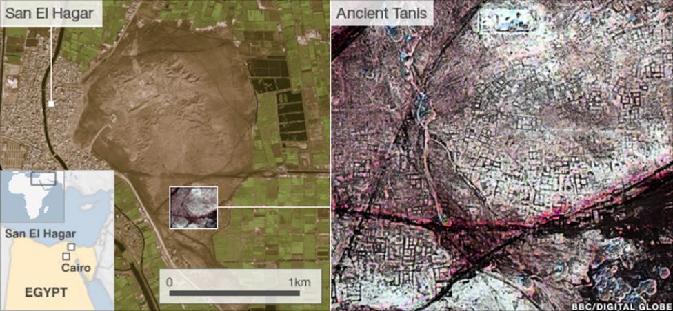
To further test some of the most recent satellite finds, Parcak enlisted the help of a French archaeological team already digging at a 3000-year-old site known as Tanis.
The satellite data revealed a warren of mud-brick walls, mazelike streets, and large residences that may have housed the wealthy. So the French team chose a structure from the images and excavated there. Beneath about 30 centimetres of sediments, they discovered mud-brick walls.
“They found an almost 100% correlation between what we see on the imagery and what we see on the ground,” Parcak says. “So this gives a significant amount of credence to what we see in the whole image.”
“It’s really incredible work, particularly the results for Tanis,” says Peter Lacovara, an Egyptologist at the Michael C. Carlos Museum in Atlanta, who is not a member of Parcak’s team. “You can see the entire city plan under the sands.”
The greatest payoff may become apparent in years to come, adds Lacovara, as the Egyptian government develops a space-based archaeological monitoring system founded on satellite data.
“Ancient sites are all over the place in Egypt,” Lacovara concludes. “And there’s just not enough time and money to monitor them on the ground.”