Archaeologists have discovered the ruins of what may be one of the four lost Ancient Egyptian “Sun Temples”
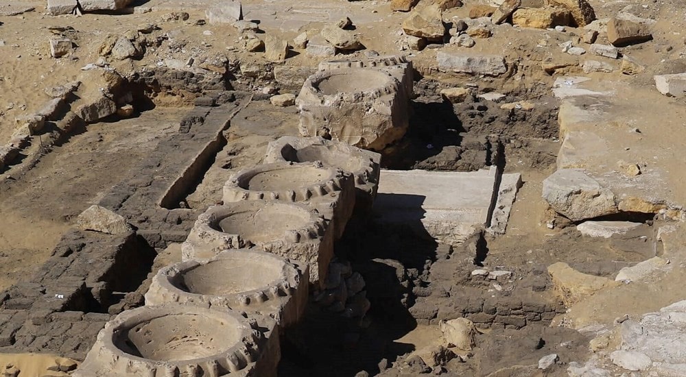
A Polish and Italian archaeological mission, while conducting an excavation in the Abusir necropolis near Saqqara in Egypt, unearthed the remains of a mud-brick building believed to be one of the lost “sun temples” of ancient Egypt’s Fifth Dynasty.
The discovery hints that the remains might belong to one of the lost four solar temples from Dynasty 5, known only in historical sources but yet to have been found thus far.
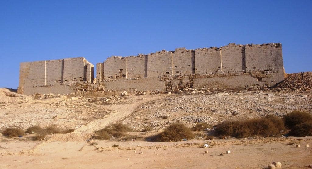
According to a statement released by the Egyptian Ministry of Antiquities and Tourism on Saturday, the building was discovered beneath the King Nyuserre temple in the Abusir area, south of Cairo.
“Preliminary studies indicate that the new discovery may be one of the four lost sun temples that date back to the Fifth Dynasty,” the ministry statement said.
These temples are thought to date back to the Fifth Dynasty (2465 to 2323 BC).
Abusir is an Old Kingdom necropolis that functioned as one of the principal cemeteries for Memphis, the Ancient Egyptian capital. The site comprises of 14 royal pyramids, mastaba, and tombs dating from the early 25th century BC to the mid-24th century BC.
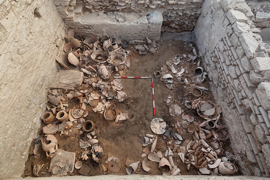
In a context layer that pre-dates the temple, the team found evidence of a mud-brick building and quartz blocks, that according to officials from the Egyptian Ministry of Tourism and Antiquities, could be the remains of one of the four lost sun temples.
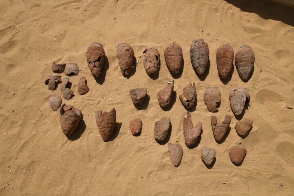
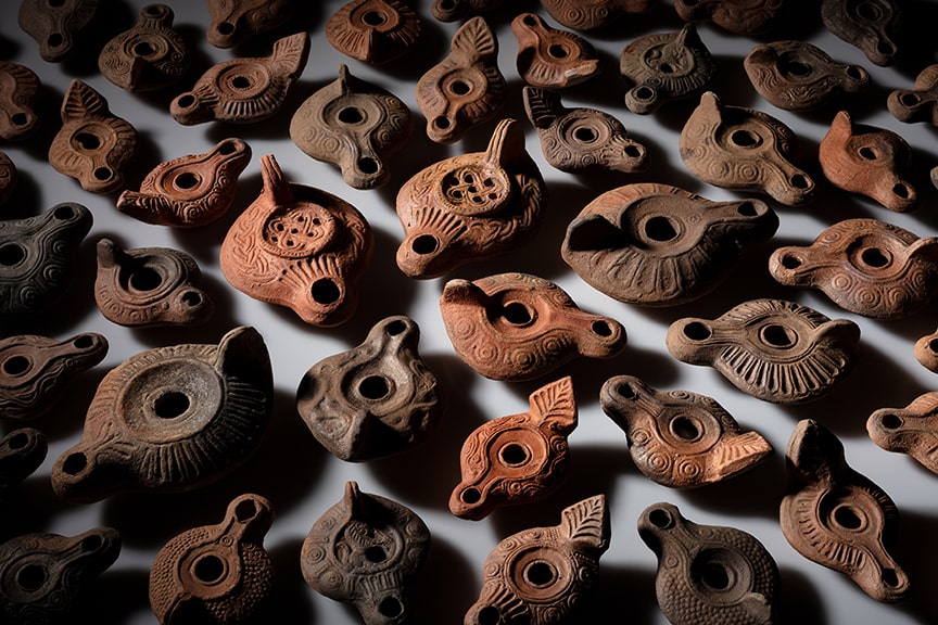
Ceramics were discovered in situ.
The Egyptian Ministry of Antiquities and Tourism said in a statement: “The building is accessible through an entrance built in the limestone rock, leading to an area with a paved floor and containing huge blocks of quartz.”
Although it is believed that six sun temples were constructed, only two have been found thus far.
Sun temples were constructed to honour the Ancient Egyptian god Ra, the god of the sun, order, kings, and the sky.
The temples of the Fifth Dynasty usually consisted of three parts: a considerably smaller entry structure, and a causeway leading to the main temple building at a higher height.
Excavations also uncovered ceramic vessels, beer pots, and red-rimmed containers, which were likely used in temple rituals and ceremonies.
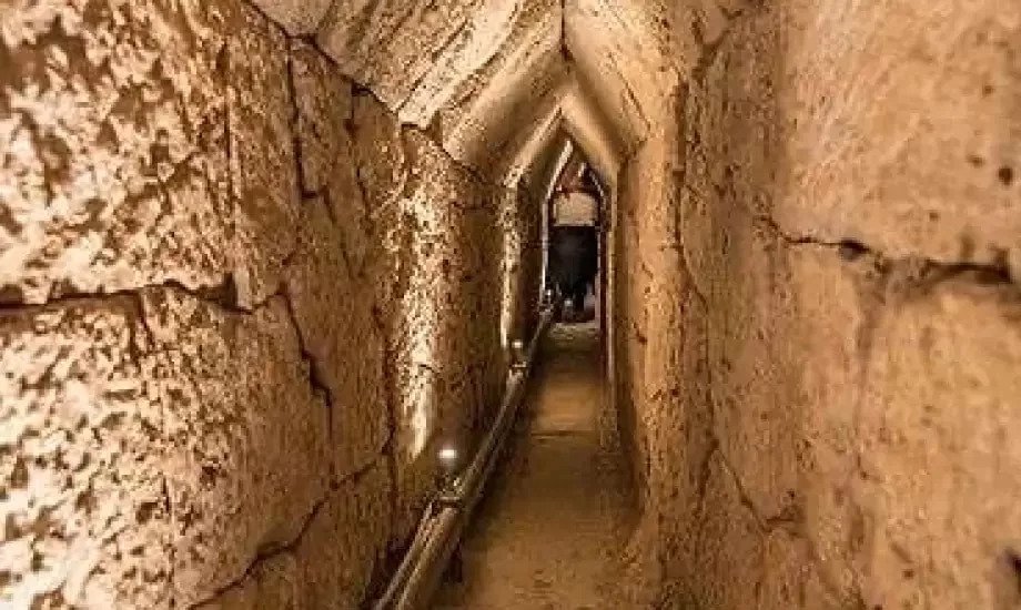
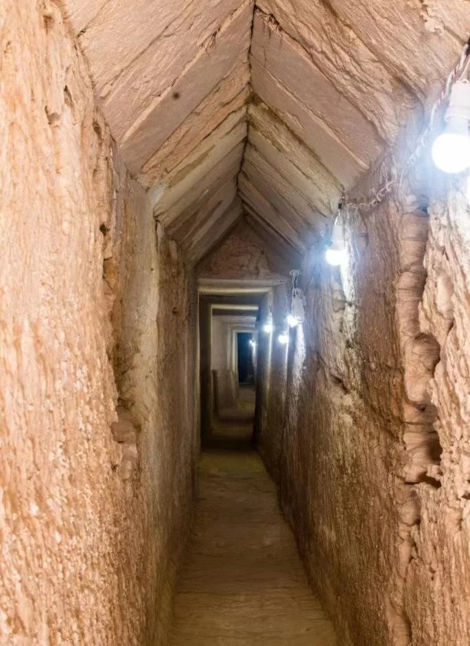
Dominican mission discovers 1,305-meter Greco-Roman ancient rock-cut tunnel in Alexandria
A Greco-Roman tunnel measuring 1,305 meters in length was discovered beneath Tapuziris Magna, an Ancient Egyptian city, by an Egyptian-Dominican archaeological mission from the University of Santo Domingo.
The tunnel was carved into the rock and is 1,305 m long, 2 meters high and 13 meters underground, according to a statement released on Thursday by the Egyptian Ministry of Tourism and Antiquities.
The team, led by archaeologist Kathleen Martinez, found the heads of two Ptolemaic-era alabaster statues near the temple, one of which was likely a sphinx representation.
Dr. Kathleen Martins, head of the mission, explained that initial studies indicate that the architectural design of the uncovered tunnel is very similar to the Yubilinus tunnel project in Greece, but is longer, describing it as an engineering miracle.
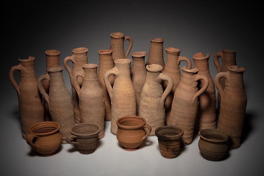
She added by saying that several pottery pots and ceramic jars, as well as a rectangular block of limestone, were discovered beneath the mud and sand during the excavations and archaeological survey of the tunnel.
The mission is attempting to uncover a portion of the Temple of Taposiris Magna’s foundations that have been revealed by numerous pieces of archaeological evidence.
According to scientific sources, at least 23 earthquakes struck the Egyptian coast between 320 AD and 1303 AD, causing a portion of the temple of Taposiris Magna to collapse and sink beneath the waves.
North View of Taposiris Magna Osiris Temple.
It is worth noting that the Egyptian- Dominican mission was able to find many important artefacts inside the temple during previous excavation seasons, including coins bearing the images and names of Queen Cleopatra IIV and Alexander the Great, as well as several headless statues and statues of the goddess Isis, as well as various inscriptions and busts of various shapes and sizes.
The mission also discovered a network of tunnels stretching from King Marriott Lake to the Mediterranean, 16 burials inside rock-cut tombs commonly used in the Greek and Roman periods, and several mummies highlighting the features of the mummification process during the Greek and Roman periods.
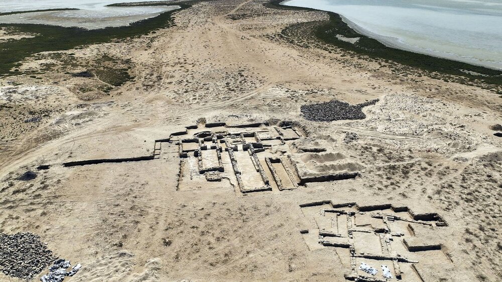
A Christian monastery, possibly pre-dating Islam, found in UAE
A Christian monastery has been discovered on the island of Siniyah off the coast of the United Arab Emirates (UAE), possibly dating back to the years before the spread of Islam to the Arabian Peninsula.
Archaeologists have discovered similar churches and monasteries in Iran and other Persian Gulf countries. Early churches and monasteries are thought to have spread from the Persian Gulf to the coasts of modern-day Oman and all the way to India.
The Siniyah Island monastery, part of the sand-dune sheikhdom of Umm al-Quwain, sheds new light on the history of early Christianity along the Persian Gulf’s shores.
The monastery is located on Siniyah Island, a barrier island protecting the Khor al-Beida marshlands in Umm al-Quwain, an emirate along the Persian Gulf coast about 30 miles northeast of Dubai. Carbon dating of samples found in the monastery’s foundation dates between 534 and 656.
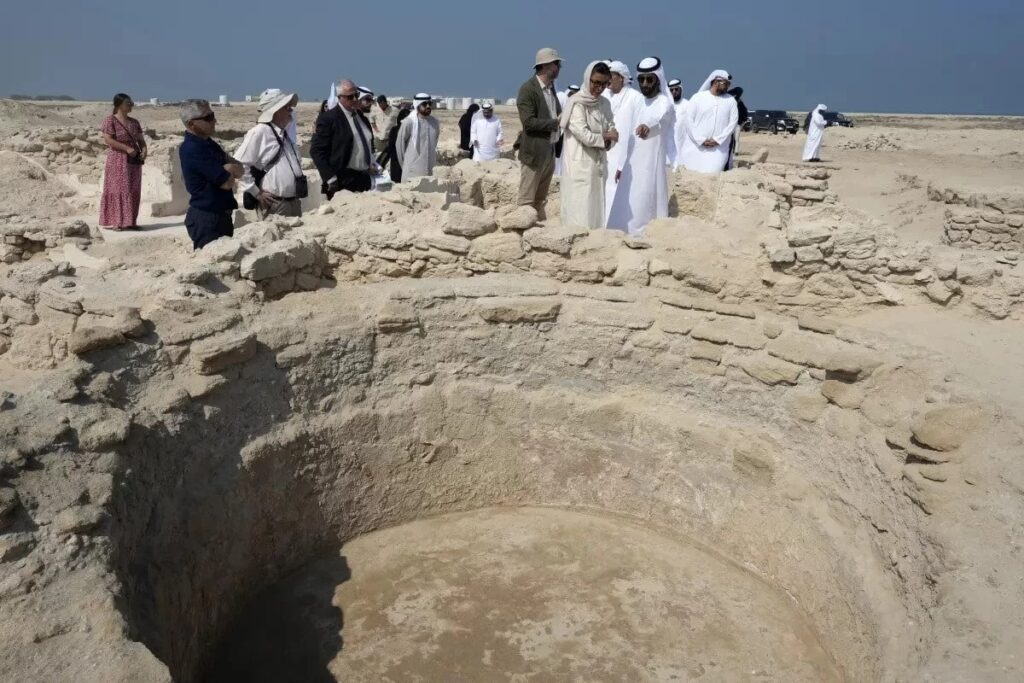
It marks the second such monastery found in the Emirates, dating back as many as 1,400 years — long before its desert expanses gave birth to a thriving oil industry which led to a unified nation home to the high-rise towers of Abu Dhabi and Dubai.
Scholars believe the two monasteries were lost to history as Christians gradually converted to Islam as Islam became more prevalent in the region.
Observers visit an ancient Christian monastery on Siniyah Island in the United Arab Emirates on Thursday.
For Timothy Power, an associate professor of archaeology at the United Arab Emirates University who helped investigate the newly discovered monastery, the UAE today is a “melting pot of nations.”
“The fact that something similar was happening here 1,000 years ago is really remarkable, and this is a story that deserves to be told,” he said.
The floor plan of the monastery on Siniyah Island suggests that early Christians may have prayed inside a single-aisle church there. Rooms within appear to hold a baptismal font, as well as an oven for baking bread or wafers for communion rites. Additionally, an altar and a setup for communion wine were probably located in a nave.
Next to the monastery is a second structure with four rooms arranged around a courtyard, which could have been the home of an abbot or a bishop in the early church.
Archaeologists discovered the first Christian monastery in the UAE in the early 1990s on Sir Bani Yas Island, which is now a nature preserve and home to luxury hotels off the coast of Abu Dhabi, near the Saudi border. It dates back to the same period as the new find in Umm al-Quwain.
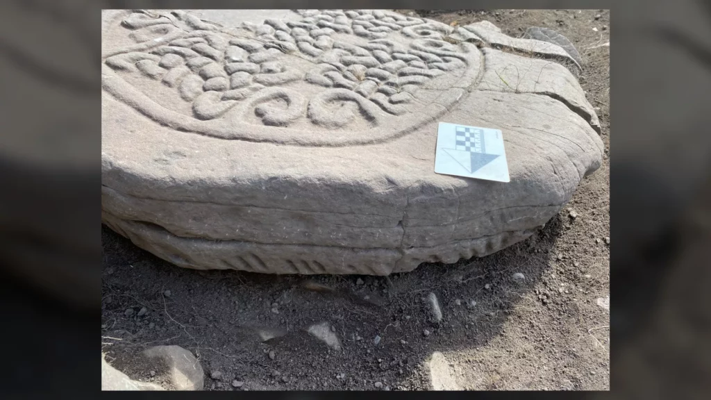
Rare medieval script discovered on stone carved by Scotland’s ‘Painted People’
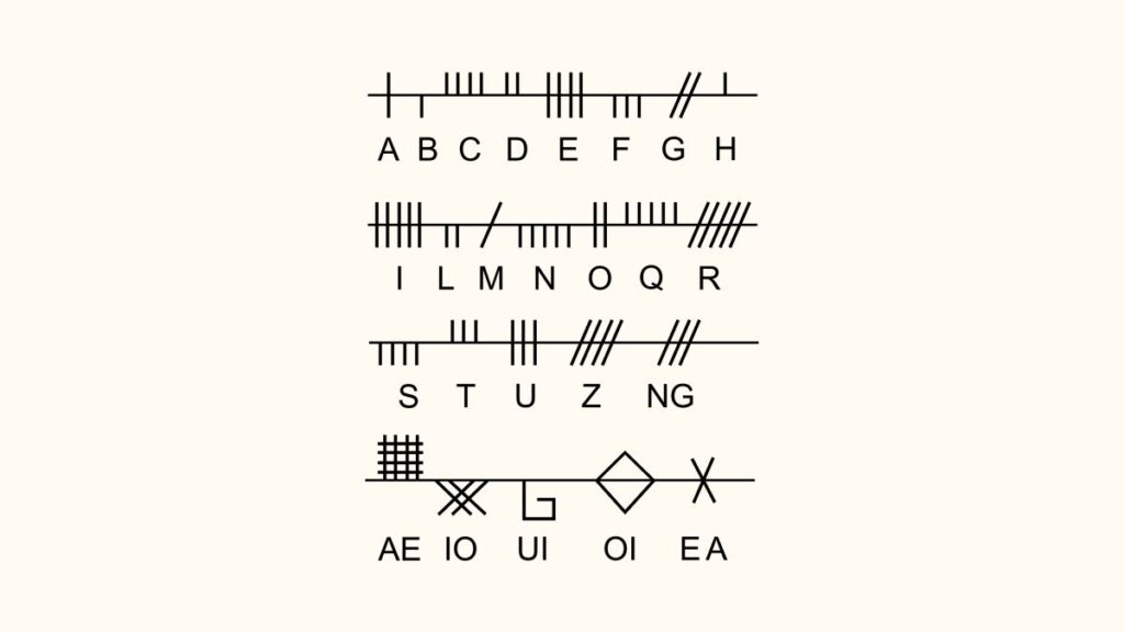
This image shows a close-up of an ogham alphabet inscription on a Pictish cross slab.
Archaeologists and volunteers have discovered a stone bearing a mysterious inscription and carved birds that the Picts of Scotland crafted more than a millennium ago. The cross slab, found in a small cemetery last month, dates to between A.D. 500 and 700, and sheds new light on the historic interaction between heritage and faith in the northern U.K.
The Picts, or “Painted People,” were so-named by Roman historians because of their supposed war paint and tattoos (“picti,” is the Latin word for “paint”). They lived in northern and eastern Scotland in the early medieval period. Likely descended from Celtic tribes, the Picts are famous for successfully resisting Roman conquest. While the Romans painted the Picts as barbarous and backward, they were largely subsistence farmers, growing grain and herding domesticated animals.
After the Roman Empire withdrew from the British Isles in the fifth century A.D., Pictish society grew to form a permanent but unstable monarchy intent on protecting its territorial boundaries. Early missionaries from Ireland converted many kings of Pictland to Christianity in the mid-sixth century A.D. Then, at the Battle of Dun Nechtain in A.D. 685, the Picts pushed the Britons out of Scotland and created a mini-empire that would last until around A.D. 900 and the arrival of the Vikings.
But the newly uncovered cross slab, found in the Old Kilmadock cemetery near Doune, Scotland, a region that was historically a buffer zone between the Picts and the Romans, and later the Britons, complicates that tidy history. “The cross slab is the first one in this region, and may mean that the residents started to think of themselves as Picts,” Stirling Council archaeologist Murray Cook, who led the recent excavation, told Live Science in an email.
Carved stones from early medieval Scotland are relatively common, but the newly discovered one from the Old Kilmadock cemetery, which has yet to be fully excavated, has three intriguing features: a rounded top, animal figural decorations and an inscription written in a medieval alphabet called ogham.
At 47 inches (119 centimeters) high and 32 inches (82 cm) wide, the Old Kilmadock stone is similar in size and shape to a large grave marker. Experts, however, think that they may have served multiple functions.
Kelly Kilpatrick, a historian and Celticist at the University of Glasgow, told Live Science in an email that cross slabs “could be grave markers, and used to communicate Christian messages to a lay audience through imagery. Sometimes you find iconography from native Pictish religion intermixed with Christian iconography on these types of monuments.” But its rounded top and circular, knotted cross make the Old Kilmadock stone a rare type of Pictish cross slab.
“The tips of the scrolls end with bird heads; they might be pelicans, as there is a tradition of the pelican biting its own flesh to feed to its young, echoing Christ and the Last Supper, which becomes the Eucharist,” Cook explained. Below that, there is a Pictish style carved four-legged animal that looks like a bull. “The bull might be a symbol of a family, a region, or a god,” Cook said.
A look at the Ogham alphabet, which was formed by creating parallel strokes and slashes along a central line.
An ogham inscription running around the side of the stone has astounded researchers. Ogham was used to write an early version of the Irish language, and it was formed by making parallel strokes and slashes along a central line. About 400 of these inscriptions have survived to the present day, mostly in Ireland, but the one from Old Kilmadock is the first to be found in central Scotland.
Kelly Kilpatrick, who will be translating the inscription, said that “it is not possible to read the ogham inscription until the stone is lifted, because ogham is written on the edge of the stone and the letters can extend to either side of this.” Ogham inscriptions in general tend to spell out names of wealthy or powerful people, however.
“The cross from Old Kilmadock is a huge new find,” Adrián Maldonado, a research fellow at National Museums Scotland who was not involved in the discovery, told Live Science. “The most important part of the discovery is the ogham inscription; when it is fully revealed, it can tell us more about the language spoken by those in power in this area, and potentially add a new, unrecorded name in a time with very few historical sources.”
Cook suggests that the cross slab was originally used as “a public statue erected by a wealthy patron to celebrate both their Pictish heritage and their Christian faith. The ogham reflects the influence of Irish Christians.” Findings in other parts of the Old Kilmadock cemetery support that interpretation: Three additional inscribed stones have been found in two different alphabets. “I think this means they were a literate and intelligent religious community,” Cook said; there was “probably a monastery.”
The Pictish cross slab likely survived because it was reused in much later times as a grave covering in the Old Kilmadock cemetery. Cook and Kilpatrick plan to further study the cross slab once it is fully excavated and its pieces put back together. In collaboration with the local Rescuers of Old Kilmadock group, they are currently raising funds for this analysis, which will cost thousands of dollars.
“This discovery shows the value of archaeological investigation of early church sites in Scotland,” Maldonado concluded, “too few of which have been excavated. It is a huge win for community-led research, providing value both for local heritage and internationally.”
DNA Study Reveals Human Migration Routes in South America
The Americas were the last continent to be inhabited by humans. An increasing body of archaeological and genomic evidence has hinted at a complex settlement process. This is especially true for South America, where unexpected ancestral signals have raised perplexing scenarios for the early migrations into different regions of the continent.
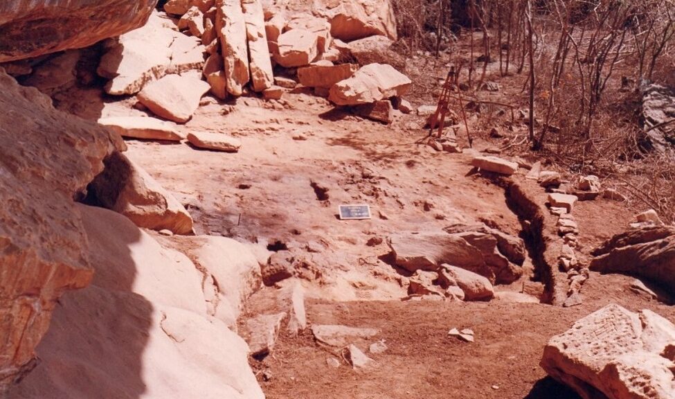
The Alcobaça archaeological site, in which the skeletal remains of Brazil-12 (northeast Brazil) were unearthed.
Many unanswered questions still persist, such as whether the first humans migrated south along the Pacific coast or by some other route. While there is archaeological evidence for a north-to-south migration during the initial peopling of the Americas by ancient Indigenous peoples, where these ancient humans went after they arrived has remained elusive.
Using DNA from two ancient human individuals unearthed in two different archaeological sites in northeast Brazil – Pedra do Tubarão and Alcobaça – and powerful algorithms and genomic analyses, Florida Atlantic University researchers in collaboration with Emory University have unravelled the deep demographic history of South America at the regional level with some unexpected and surprising results.
Not only do researchers provide new genetic evidence supporting existing archaeological data of the north-to-south migration toward South America, but they also have discovered migrations in the opposite direction along the Atlantic coast – for the first time. The work provides the most complete genetic evidence to date for complex ancient Central and South American migration routes.
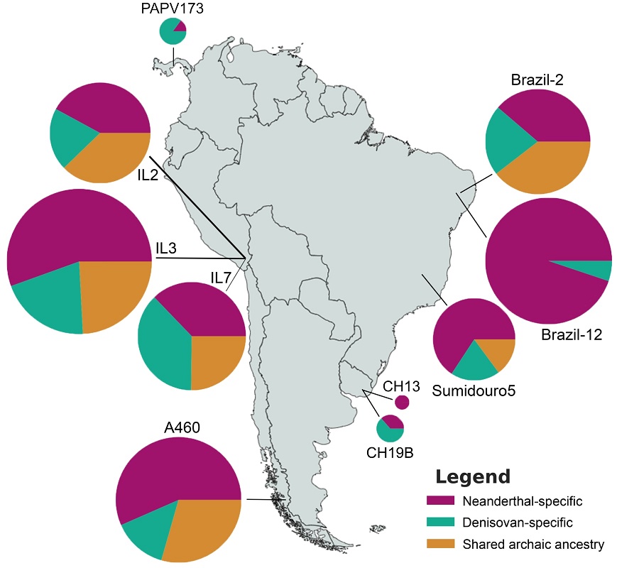
Among the key findings, researchers also have discovered evidence of Neanderthal ancestry within the genomes of ancient individuals from South America. Neanderthals are an extinct population of archaic humans that ranged across Eurasia during the Lower and Middle Paleolithic.
Results of the study, published in the journal Proceedings of the Royal Society B. (Biological Sciences), suggest that human movements closer to the Atlantic coast eventually linked ancient Uruguay and Panama in a south-to-north migration route – 5,277 kilometres (3,270 miles) apart. This novel migration pattern is estimated to have occurred approximately 1,000 years ago based on the ages of the ancient individuals.
Findings show a distinct relationship among ancient genomes from northeast Brazil, Lagoa Santa (southeast Brazil), Uruguay and Panama. This new model reveals that the settlement of the Atlantic coast occurred only after the peopling of most of the Pacific coast and Andes.
“Our study provides key genomic evidence for ancient migration events at the regional scale along South America’s Atlantic coast,” said Michael DeGiorgio, Ph.D., co-corresponding author who specializes in human, evolutionary, and computational genomics and is an associate professor in the Department of Electrical Engineering and Computer Science within FAU’s College of Engineering and Computer Science. “These regional events likely derived from migratory waves involving the initial Indigenous peoples of South America near the Pacific coast.”
Researchers also found strong Australasian (Australia and Papua New Guinea) genetic signals in an ancient genome from Panama.
“There is an entire Pacific Ocean between Australasia and the Americas, and we still don’t know how these ancestral genomic signals appeared in Central and South America without leaving traces in North America,” said Andre Luiz Campelo dos Santos, Ph.D., first author, an archaeologist and a postdoctoral fellow in FAU’s Department of Electrical Engineering and Computer Science.
To further add to the existing complexity, researchers also detected greater Denisovan than Neanderthal ancestry in ancient Uruguay and Panama individuals. Denisovans are a group of extinct humans first identified from DNA sequences from the tip of finger bone discovered around 2008.
“It’s phenomenal that Denisovan ancestry made it all the way to South America,” says John Lindo, Ph.D., a co-corresponding author of the article who specializes in ancient DNA analysis and is an assistant professor in the Department of Anthropology at Emory University. “The admixture must have occurred a long time before, perhaps 40,000 years ago. The fact that the Denisovan lineage persisted and its genetic signal made it into an ancient individual from Uruguay that is only 1,500 years old suggests that it was a large admixture event between a population of humans and Denisovans.”
Previously at the Federal University of Pernambuco in Recife, Brazil, dos Santos and colleagues uncovered the remains of the two ancient humans from northeast Brazil, which date back to at least 1,000 years before present, and sent them to Lindo for DNA extraction and subsequent genomic sequencing and analyses. Raw data were then sent to FAU for computational analysis of the whole genome sequences from northeast Brazil.
Researchers compared the two newly sequenced ancient whole genomes from northeast Brazil with present-day worldwide genomes and other ancient whole genomes from the Americas. As of the publication date of the article, Lindo says that only a dozen or so ancient whole genomes from South America have been sequenced and published, in contrast to hundreds from Europe.
Apart from the occurrence of mass burials in the sites that yielded the samples from northeast Brazil, Uruguay, southeast Brazil and Panama, there is no other evidence in the archaeological record that indicate shared cultural features among them. Importantly, the analyzed ancient individuals from southeast Brazil are about 9,000 years older than those from northeast Brazil, Uruguay and Panama, enough time for expected and noticeable cultural divergence. Moreover, northeast Brazil, Uruguay and Panama, though more similar in age, are located thousands of kilometers apart from each other.
“This groundbreaking research involved many different fields from archaeology to biological sciences to genomics and data science,” said Stella Batalama, Ph.D., dean, FAU College of Engineering and Computer Science. “Our scientists at Florida Atlantic University in collaboration with Emory University have helped to shed light on an important piece of the Americas puzzle, which could not have been solved without powerful genomic and computational tools and analysis.”
Study co-authors are Amanda Owings, Ph.D., Emory University; Henry Socrates Lavalle Sullasi, Ph.D., Federal University of Pernambuco, Brazil; and Omer Gokcumen, Ph.D., State University New York at Buffalo.
This research was supported by the National Science Foundation, National Institutes of Health, and the Fundação de Amparo à Ciência e Tecnologia de Pernambuco.
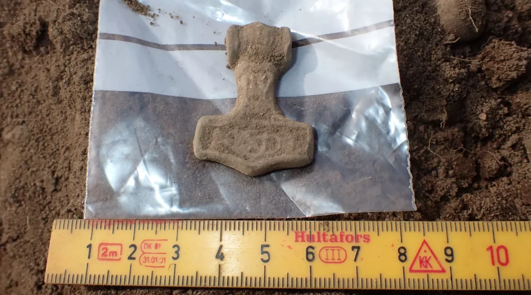
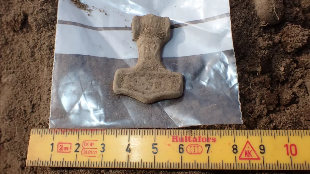
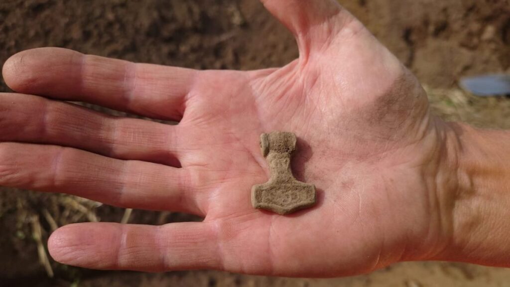
A 1,000-year-old amulet of Thor’s Hammer discovered in Sweden shows the lasting popularity of the ancient Norse deity, who has now won a new audience with Chris Hemsworth’s portrayal of the Viking god of war in Marvel movies.
Archaeologists think the amulet was worn around the neck, perhaps as spiritual protection. It’s thought the design of Thor’s Hammer could signify an adherence to the old religion of Norse gods, rather than to the “new” Christian religion.
Thor had always been a popular figure, perhaps because he was concerned about humans, Carolyne Larrington, a professor of medieval European literature at the University of Oxford, told Live Science.
“Of all the Norse gods, Thor is the one most interested in the fate of humanity,” said Larrington, author of the upcoming book “The Norse Myths that Shape the Way We Think,” (Thames and Hudson Ltd, 2023) who wasn’t involved in the recent discovery. “His main job was patrolling the east and keeping the giants [the Jötnar] out of the lands of humans and the gods with his hammer.”
Archaeologists unearthed the amulet over the summer during excavations near the southwestern town of Ysby, Per Wranning, the head of archaeology at the Cultural History Museum in Halland County, told Live Science in an email.
The region faces Denmark across the strait between the North Sea and the Baltic, which for centuries has been called the Kattegat — “cat’s passage” — because it is dangerously shallow.
The archaeological investigations of the site, which has been earmarked for new houses, have also revealed several firepits, post holes and pieces of pottery and metal that may date to before the end of the late Viking Age in the mid-11th century A.D, he said.
The Thor’s Hammer amulet was found in the southwestern Swedish town of Ysby this summer. It is thought to be made of lead and is dated to around the 10th or 11th centuries A.D.
Viking Age
Similar Thor’s hammer amulets have been found previously in Scandinavia, but this is the first uncovered in Halland, said Wranning, who led the dig.
It’s cast in metal and has intricate embossed designs on its upper face, and it may have been gilded (decorated with gold) or silvered, but the archaeologists won’t be sure until it’s been properly cleaned and preserved, he said.
A hole in the shaft — the bottom of the “handle” of the hammer — indicates the amulet was hung on a ring or thong and suggests it was worn around the neck, but it might have formed some other type of jewellery, he added. “The find probably dates to the 900s or 1000s — that is, the late Viking Age — and appears to be made of lead,” Wranning wrote in a translated blog post.
Such amulets might have been worn during the religious transition of the region at the end of the Viking Age as a symbol of adhering to the old Norse gods, rather than to the “new” religion of Christianity.
“One theory is that these large, ornamented Thor’s hammers were a clear marker for those who still worshipped the [Norse] gods when Christianity began to take root in Scandinavia,” he said.
Preliminary dating of the latest finds at Ysby suggests they are from the Viking Age, which traditionally starts in 793 — the date of the first Viking raid in England, on a monastery on the holy island of Lindisfarne on the coast of Northumberland — and ends with the Battle of Stamford Bridge in September 1066, where an English army led by King Harold Godwinson defeated an invading Norwegian army near York.
Thor’s Hammer
The divine hammer represented by the amulet is the war hammer Mjölnir , which according to legend was crafted by dwarves for the gods of Valhalla in a competition to create the most wondrous treasure, Larrington said.
Although the other treasures included a ship that could fold up and be placed in a pocket and the gold-bristled, glow-in-the-dark boar called Gullinbursti that could be ridden into battle, Mjölnir was judged the most marvellous and was given to Thor for his wars against the giants, she said.
“It has both a destructive power and a sacred power,” she said. “It seems to have been used to hallow things, to make them sacred.”
When worn as an amulet, representations of Mjölnir might have been thought of as a form of spiritual defense: “It’s protecting you, in a very positive way,” she said.
Thor was also a god of the weather, and through that association, he was a god of seafaring. “If you’re sailing from Norway to Iceland, you want decent weather, you don’t want a storm — and Thor is very much connected with that,” Larrington said.
She noted that Ysby, where the amulet was found, is only a few miles from the coast. “So I would imagine it is about travelling,” she said.
According to the blog post by Wranning, the remains of two “longhouses” from the late Iron Age have been found at Ysby, and walls from a Christian church built in the 1100s or 1200s.
Early maps also show a ford across the nearby Lagan River: “this could have contributed to the fact that the site has been of interest to control in ancient times,” he wrote.
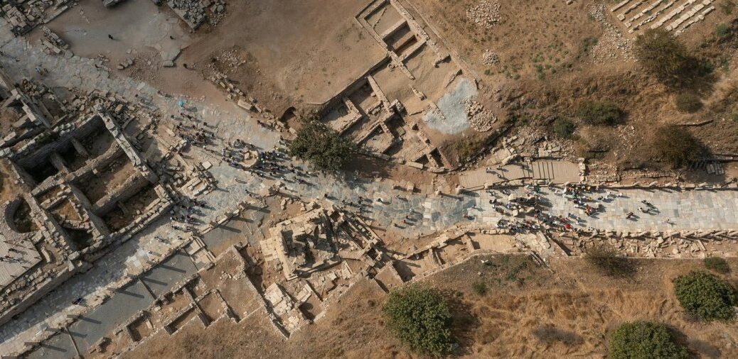
Sensational find in Ephesus: more than 1,400-year-old district discovered
During this year’s excavations at Ephesus in Turkey, archaeologists from the Austrian Academy of Sciences (AW) discovered an incredibly well-preserved early Byzantine business and dining space that had apparently been destroyed suddenly in AD 614/615.
The discovery, according to the head of the excavation Sabine Ladstätter, is the most significant one to have occurred in the ancient city since the discovery of its renowned hill houses.
Ephesus is one of the world’s largest and most impressive ancient cities, as well as one of Turkey’s most important ancient cities.
Its cultural and historical significance was highlighted in its addition to the UNESCO World Heritage Site list in 2015.
The remains of the city lie just 80 km inland from the popular seaside city of İzmir and close to the charming towns of Selcuk and Sirince.
Numerous oil lamps were unearthed in one of the shop rooms.
The newly discovered neighbourhood is on Domitian Square, a prominent square directly adjacent to the Roman city’s political centre, the Upper Agora.
The excavations this year are part of a large research project on Ephesus’ changes between the Roman Empire and Late Antiquity.
Byzantine shops and workshops were built over a large Roman square complex, with the team focusing excavations on a structure consisting of several business premises that covers an area of around 170 square meters.
A storage room was also discovered, which was full of vessels that could still be found with their original contents.
The researchers dug up filling material meters high and eventually arrived at a fire layer about half a meter thick. Sealed by this, a unique snapshot of life at the time was preserved at a depth of about 3.5 meters.
Individual rooms are preserved, containing thousands of pieces of ceramics, including whole bowls with the remains of seafood such as cockles or oysters, as well as amphorae filled with salted mackerel.
Also found were thousands of barrels, including whole bowls of seafood remnants such as cockles or oysters, amphoras filled with salted mackerel, peach, almond, and olive kernels, charred pulses, with more than 700 copper coins and four matching gold coins and gold jewellery.
In the storage room, there were numerous small jugs and cups, which can be assumed to have formed a set. Filled with wine, they were served to the clientele in adjacent rooms (tabernas).
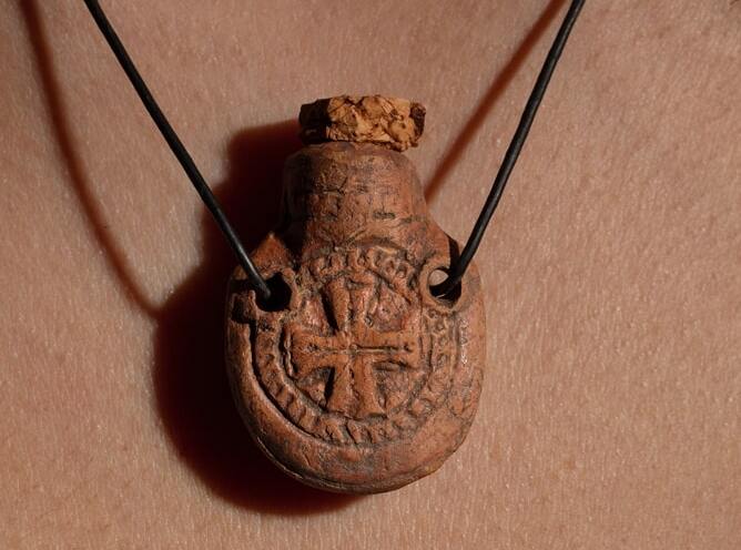
Based on the finds, it was also possible to reconstruct the earlier use of the rooms. So it is a cooking shop, a storage room, a tavern, a workshop with an adjoining sales room, and a shop for lamps and Christian pilgrim souvenirs (indicated by the discovery of around 600 small pilgrim bottles that were sold to Christian pilgrims).
However, coin dating indicates that the bustling trade and craft industry abruptly ended in the year 614/15 beneath the half-meter thick layer of fire.
The scientists surmise a military conflict because there are no signs of an earthquake, such as shifted walls or vaulted floors. The numerous spearheads and arrowheads discovered also attest to this. The causes of this were unknown prior to this.
The Christian pilgrim ampoules were only a few centimetres in size and could be worn around the neck. They contained sacred substances, such as holy dust, which could thus be taken away from Christian pilgrimage sites.
Based on the new finds, “this turning point in the history of the city of Ephesus will probably have to be associated with the Byzantine–Sasanian War”.
Priceless archaeological artefacts found in Norfolk Island National Park by local citizen scientist
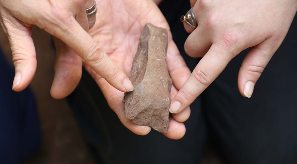
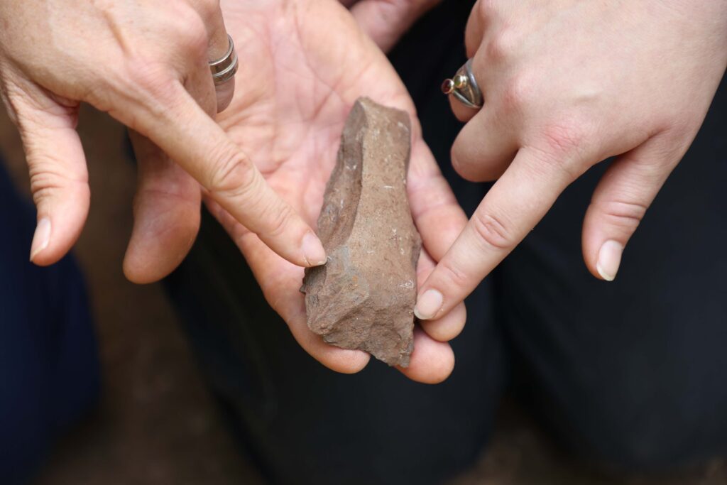
An archaeological dig on Norfolk Island has uncovered two Polynesian adzes (stone axes) and hundreds of flakes dating back to the pre-European settlement. The adzes were used for woodworking and canoe building and form hard evidence of settlement on Norfolk Island by the Polynesians during the 13th and 15th CE. Part of the Australian Museum’s first, broad-scale, multi-pronged expedition of Norfolk Island, the first pieces of the treasure trove was uncovered by local Norfolk Islander, Snowy Tavener, who identified the site on the walking track in the Norfolk Island National Park more than four years ago.
An archaeological dig on Norfolk Island has uncovered two Polynesian adzes (stone axes) and hundreds of flakes dating back to the pre-European settlement.
“For many years, I’ve been walking this track searching for evidence of a new Polynesian site on our island, so when I came across these flakes I couldn’t believe my eyes,” Snowy said.
“The track is an extremely popular bushwalking path and has been driven and walked over for hundreds of years, but before we told the wider community about our find, I wanted it confirmed by archaeologists,” Snowy explained.
“I showed the site to my friend, Deb Jorgensen, who has a daughter, Nicola Jorgensen, studying Archaeology at the University of Sydney under Dr Amy Mosig Way from the Australian Museum, and the University of Sydney,” Snowy said.
“Nicola was immediately interested and so she and her supervisor came over last year to confirm that it was indeed a potential new Polynesian site,” Snowy added.
Now completing her Master’s degree, Jorgensen said the flakes and adzes are made from basalt and are a tangible link back to the Polynesian heritage of Norfolk Island.
“The number of artefacts not only indicates the level of activity that occurred on the site but also confirms that this is another site made by the original Polynesian ancestors, with the other first settlement site being located at Emily Bay,” Jorgensen said.
Reflecting on the importance of the find, Jorgensen said it was exciting to her that this research commenced with local knowledge.
“I grew up here on beautiful Norfolk Island and like Snowy, feel proud to call it home. Local conservation efforts and preservation of our flora, fauna and historical sites can not only help advance scientific studies but are also more likely to deliver positive outcomes for our community,” Jorgensen added.
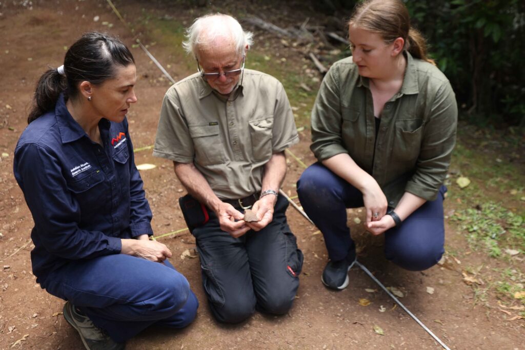
Dr Amy Mosig Way and local Norfolk Islander, Snowy Tavener uncover two Polynesian adzes (stone axes).
Australian Museum archaeologist, Dr Mosig Way, said the significance of the discovery is that it demonstrates the extent of the Polynesian settlement across the island.
“No longer can the idea of Polynesians inhabiting the island be thought of as fleeting,” Dr Mosig Way said
“The artefacts can provide us with an understanding of the behaviours, the possessions and the movement of the former Polynesian inhabitants of Norfolk Island. And what is particularly exciting is the preservation of the artefacts, despite the traffic that has occurred on this track during the last few hundred years,” Dr Mosig Way explained.
Norfolk Island National Park Manager Nigel Greenup said that the discovery of the adze was significant.
“This discovery of an adze in Norfolk Island National Park indicates historical links with Polynesian people who first called Norfolk Island home – well before the colonial settlement of the island,” Mr Greenup said.
“We will continue to work with the community and archaeologists to conserve this cultural heritage.”
Australian Museum Chief Scientist, Professor Kris Helgen, acknowledged that keen observations and persistence shown by Snowy have been the key to this extraordinary find.
“Incorporating local knowledge into our analysing and collecting methods is integral to the Australian Museum’s scientific research,” Helgen said.
“I am impressed not only by Snowy’s knowledge but also by the enthusiasm and pride of the whole local community. I know we are all thrilled by these discoveries,” Helgen added.
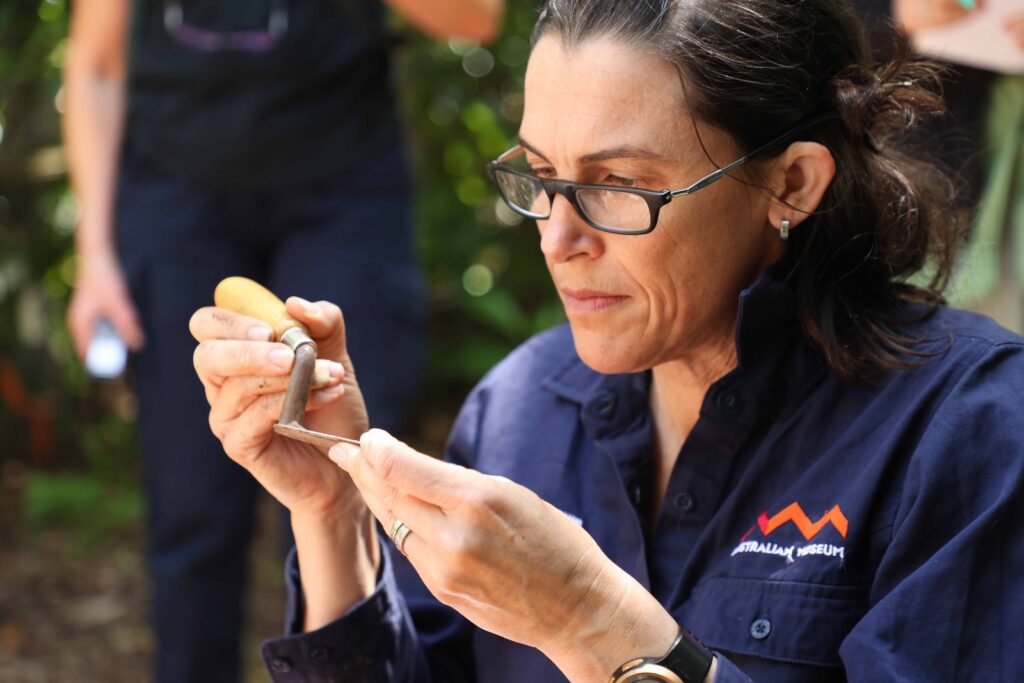
Dr Amy Mosig Way, part of the Australian Museum’s first broad-scale multi-pronged expedition of Norfolk Island.
Supported by Norfolk Island National Park Manager Nigel Greenup, Jorgensen, Snowy and Dr Mosig Way have carefully excavated, retrieved and recorded the items to ensure they are well-documented and conserved.
Once the dig is finished, the artefacts will be analysed and catalogued by the scientists with the findings and acknowledgement of the local community to be included in a scientific paper. The artefacts will initially be stored on Norfolk Island while a process of community consultation is undertaken to seek views on the long-term preservation and display of the items.
Funded through the Australian Museum Foundation, the Norfolk Island expedition is a collaboration with the Norfolk Island community, Parks Australia, the Australian Institute of Botanical Science and the Auckland War Memorial Museum.
Nicola Jorgensen’s project is supervised by Dr Amy Mosig Way, Scientific Officer, Archaeology, Australian Museum and the University of Sydney.