Giant 66-Million-Year-Old Marine Reptile Found in Morocco
Researchers in Morocco have discovered a huge new mosasaur fossil called Thalassotitan aatrox that fills the super-hunter niche. With huge jaws and teeth like those of killer whales, the Thalassotitan preyed on other marine reptiles, plesiosaurs, sea turtles, and other mosasaurs.
It is known that at the end of the Cretaceous period, 66 million years ago, sea monsters really existed. While dinosaurs grew up on land, the seas were dominated by mosasaurs, giant marine reptiles.

Mosasaurs weren’t dinosaurs, they were huge marine reptiles that grew up to 12 meters long. They are known as distant relatives of modern iguanas and monitor lizards.
Mosasaurs looked like a Komodo dragons, with fins instead of legs and a shark-like tail fin. Mosasaurs became larger and more specialized during the last 25 million years of the Cretaceous, taking up niches once populated by marine reptiles such as plesiosaurs and ichthyosaurs.
Some have evolved to eat tiny prey such as fish and squid. Others ate ammonites and oysters. The newly discovered mosasaur, named Thalassotitan atrox, evolved to prey on all other marine reptiles.
The remains of the new species were excavated in Morocco, about an hour from Casablanca. Here, towards the end of the Cretaceous, the Atlantic had flooded northern Africa.
The nutrient-rich waters rising from the depths feed the plankton. They feed the small fish, they feed the bigger fish. These large fish preyed upon mosasaurs and plesiosaurs. These marine reptiles become food for the giant, carnivorous Thalassotitan.
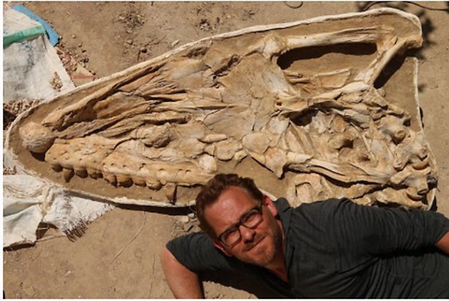
Thalassotitan had a gigantic 1.4-metre-long skull, reaching nearly 9 meters in length, the size of a killer whale. While most mosasaurs had long jaws and fine teeth for catching fish, Thalassotitan had short, broad, and large, conical teeth like an orca. These allowed it to catch and shred large prey.
These adaptations suggest that Thalassotitan was a super predator that stood at the top of the food chain. The giant mosasaur occupied the same ecological niche as modern-day killer whales and great white sharks.
Thalassotitan’s teeth were often broken and worn, but eating fish does not cause this type of tooth wear. Thus, the giant mosasaur appears to have attacked other marine reptiles, breaking its teeth while biting and smashing their bones. Some teeth were so badly damaged that they were crushed almost to the root.

Possible remains of Thalassotitan’s victims have been discovered. Fossils from the same deposits bear acid-induced damage. Among these, strangely damaged fossils were found large predatory fish, a sea turtle, a half-metre-long plesiosaur head, and the jaws and skulls of at least three different mosasaur species. They must have been digested in Thalassotitan’s stomach before spitting out his bones.
Lead author of the study, Dr. Nick Longrich says, “This is circumstantial evidence. It is unlikely that we can say with certainty which animal species ate all these other mosasaurs. However, we have the bones of marine reptiles killed and eaten by a large predators. And in the same place, we find Thalassotitan, a species that fits the profile of the killer – a mosasaur specialized for preying on other marine reptiles. This is probably not a coincidence.”
Thalassotitan poses a threat to everything in the oceans, including other Thalassotitans. The huge mosasaurs have wounds inflicted in fierce combat with other mosasaurs. Other mosasaurs bore similar injuries, but these wounds were extremely common on Thalassotitan, suggesting frequent, intense fights over feeding grounds or mates.
Dr. Nick Longrich says, “The Thalassotitan is known to be an incredible, frightening animal.” Imagine a mix of killer whale, T. rex, great white shark and Komodo Dragon.”

The newly discovered mosasaur lived in the last million years of the Age of Dinosaurs, a contemporary of animals like T. rex and Triceratops. Recent discoveries of mosasaurs in Morocco show that mosasaurs were not in decline before the asteroid impact that triggered the Cretaceous mass extinction.
Professor Nour-Eddine Jalil, one of the authors of the article, from the Paris Museum of Natural History, said: “The phosphate fossils from Morocco provide a unique example of paleobiodiversity at the end of the Cretaceous.” They describe how life was rich and diverse just before the end of the ‘dinosaur age’, when animals had to specialize in order to gain a foothold in their ecosystems. Thalassotitan completes the picture by taking on the role of mega-hunter at the top of the food chain.”
Longrich said, “There is still much to be done. Morocco has one of the most diverse marine fauna known from the Cretaceous. We are beginning to understand the diversity and biology of mosasaurs today.”