Ancient DNA Sheds New Light on the Biblical Philistines
An international team, led by scientists from the Max Planck Institute for the Science of Human History and the Leon Levy Expedition, retrieved and analyzed, for the first time, genome-wide data from people who lived during the Bronze and Iron Ages (~3,600-2,800 years ago) in the ancient port city of Ashkelon, one of the core Philistine cities during the Iron Age. The team found that a European-derived ancestry was introduced in Ashkelon around the time of the Philistines’ estimated arrival, suggesting that ancestors of the Philistines migrated across the Mediterranean, reaching Ashkelon by the early Iron Age.
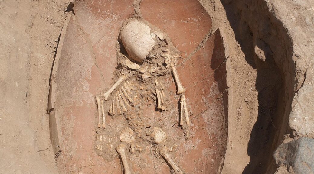
Excavation of the Philistine cemetery at Ashkelon.
This European-related genetic component was subsequently diluted by the local Levantine gene pool over the succeeding centuries, suggesting intensive admixture between local and foreign populations. These genetic results, published in Science Advances, are a critical step toward understanding the long-disputed origins of the Philistines.
The Philistines are famous for their appearance in the Hebrew Bible as the arch-enemies of the Israelites. However, the ancient texts tell little about the Philistine origins other than a later memory that the Philistines came from “Caphtor” (a Bronze Age name for Crete; Amos 9:7). More than a century ago, Egyptologists proposed that a group called the Peleset in texts of the late twelfth century BCE were the same as the Biblical Philistines.
The Egyptians claimed that the Peleset traveled from the “the islands,” attacking what is today Cyprus and the Turkish and Syrian coasts, finally attempting to invade Egypt. These hieroglyphic inscriptions were the first indication that the search for the origins of the Philistines should be focused on the late second millennium BCE. From 1985-to 2016, the Leon Levy Expedition to Ashkelon, a project of the Harvard Semitic Museum, took up the search for the origin of the Philistines at Ashkelon, one of the five “Philistine” cities according to the Hebrew Bible. Led by its founder, the late Lawrence E. Stager, and then by Daniel M. Master, and author of the study and director of the Leon Levy Expedition to Ashkelon, the team found substantial changes in ways of life during the 12th century BCE which they connected to the arrival of the Philistines.
Many scholars, however, argued that these cultural changes were merely the result of trade or a local imitation of foreign styles and not the result of a substantial movement of people.
This new study represents the culmination of more than thirty years of archaeological work and of genetic research utilizing state-of-the-art technologies, concluding that the advent of the Philistines in the southern Levant involved a movement of people from the west during the Bronze to Iron Age transition.
An infant burial at the Philistine cemetery at Ashkelon.
Genetic discontinuity between the Bronze and Iron Age people of Ashkelon
The researchers successfully recovered genomic data from the remains of 10 individuals who lived in Ashkelon during the Bronze and Iron Ages.
This data allowed the team to compare the DNA of the Bronze and Iron Age people of Ashkelon to determine how they were related.
The researchers found that individuals across all time periods derived most of their ancestry from the local Levantine gene pool, but that individuals who lived in early Iron Age Ashkelon had a European derived ancestral component that was not present in their Bronze Age predecessors.
“This genetic distinction is due to European-related gene flow introduced in Ashkelon during either the end of the Bronze Age or the beginning of the Iron Age. This timing is in accord with estimates of the Philistine’s arrival to the coast of the Levant, based on archaeological and textual records,” explains Michal Feldman of the Max Planck Institute for the Science of Human History, leading author of the study.
“While our modeling suggests a southern European gene pool as a plausible source, future sampling could identify more precisely the populations introducing the European-related component to Ashkelon.”
Transient impact of the “European related” gene flow
In analyzing later Iron Age individuals from Ashkelon, the researchers found that the European-related component could no longer be traced.
“Within no more than two centuries, this genetic footprint introduced during the early Iron Age is no longer detectable and seems to be diluted by a local Levantine related gene pool,” states Choongwon Jeong of the Max Planck Institute of the Science of Human History, one of the corresponding authors of the study.
“While, according to ancient texts, the people of Ashkelon in the first millennium BCE remained ‘Philistines’ to their neighbors, the distinctiveness of their genetic makeup was no longer clear, perhaps due to intermarriage with Levantine groups around them,” notes Master.
“This data begins to fill a temporal gap in the genetic map of the southern Levant,” explains Johannes Krause of the Max Planck Institute for the Science of Human History, senior author of the study.
“At the same time, by the zoomed-in comparative analysis of the Ashkelon genetic time transect, we find that the unique cultural features in the early Iron Age are mirrored by a distinct genetic composition of the early Iron Age people.”
The earliest evidence of the Maya divination calendar was discovered in an ancient temple
Archaeologists in Guatemala have discovered the oldest evidence of the Maya calendar on record: two mural fragments that, when pieced together, reveal a notation known as “7 deer,” a new study finds.
The two mural fragments with the 7 Deer day-sign and partial hieroglyphic text, among a total of 249 fragments of painted plaster and painted masonry blocks collected during archaeological excavations of the Ixbalamque context.
The two “7 deer” fragments date to between 300 B.C. and 200 B.C., according to radiocarbon dating done by the research team. This early date indicates that this Maya divination calendar, which was also used by other pre-Columbian cultures in Mesoamerica, such as the Aztecs, has been in continuous use for at least 2,300 years, as it is still followed today by modern Maya, the researchers said. (Notably, this is not the Long Count calendar that some people used to suggest the world was going to end in 2012.)
“It’s the one calendar that survives all the conquests and the civil war in Guatemala,” the latter of which was waged from 1960 to 1996, study first author David Stuart, the Schele professor of Mesoamerican art and writing at the University of Texas at Austin, told Live Science. “The Maya of today in many communities have kept it as a way of connecting to their ideas of fate and how people relate to the world around them. It’s not a revival. It’s actually preservation of the calendar.”
The researchers found the mural fragments at the archaeological site of San Bartolo, northeast of the ancient Maya city of Tikal. Stuart was part of the team that discovered San Bartolo in 2001. “It’s in the remote jungles of northern Guatemala” and famous for its Maya murals dating to the Late Preclassic period (400 B.C. to A.D. 200), he said.
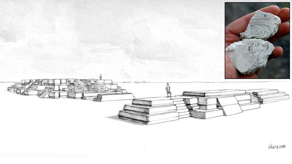
A reconstruction of San Bartolo at the phase when the 7 deer day-sign mural fragments were created.
The murals at San Bartolo are in a massive complex known as Las Pinturas, which the Maya built over hundreds of years. Every so often, the Maya would build over an old complex, constructing larger and more impressive structures. As a result, Las Pinturas is layered like an onion. If archaeologists tunnel into its inner layers, they can find earlier structures and murals, Stuart said.
The researchers collected ancient organic material, such as charcoal, within the layer where the mural fragments were discovered. By radiocarbon-dating these fragments, they could estimate when the murals were created.
However, these murals weren’t in one piece. In total, the team discovered about 7,000 fragments from various murals. Of this colossal collection, the team analyzed 11 wall fragments, discovered between 2002 and 2012, with radiocarbon dating. These included the two pieces that formed the “7 deer” notation, which includes a glyph, or image of a deer under the Maya symbol for the number seven (a horizontal line with two dots over it).
These fragments with the 7 deer day-sign dated to between 300 B.C. and 200 B.C.
The second dot over the line (top) is missing but is thought to be the number 7.
Mural fragments on masonry blocks from the Ixbalamque structure. It dates to the same time period as the 7 deer fragments but depicts the image of the Late Preclassic period Maya maize god.
Four Maya calendars
The Maya had four calendars, as “they were very interested in timekeeping,” Stuart said. “They had very elaborate and elegant ways of tracking time.”
One is the sacred divination calendar, or Tzolk’in, from which this “7 deer” notation originates. This calendar has 260 days consisting of a combination of 13 numbers and 20 days that have different signs (like deer).
The 260 days don’t make up a year, however. Rather, it’s a cycle similar to the seven-day week. The notation “7 deer” doesn’t give you a date; it doesn’t tell you the season or year in which something happened. “It’s like saying Napoleon invaded Russia on a Wednesday,” Marcello Canuto, director of the Middle American Research Institute at Tulane University, who wasn’t involved with the study, told Live Science.
Today, the 260-day cycle in the Tzolk’in calendar is used for soothsaying and ceremonial record-keeping, Stuart said. “There are date keepers, as they’re called, in Guatemala today,” Stuart said. “If you said the day is 7 deer, they would go, ‘Oh yeah, 7 deer, that means this, this and this.'”
An illustration showing the detail of the 7 deer day sign found at San Bartolo, Guatemala.
The other Maya calendars are the Haab’, a solar calendar that lasts 365 days but doesn’t account for a leap year; a lunar calendar; and the Long Count calendar, which tracks major time cycles and caused a lot of brouhahas when some people (mistakenly) thought it was foretelling the end of the world in 2012, Live Science previously reported.
“[I remember] all that nonsense back in 2012 about the end of a cycle,” Stuart said. “Everyone was saying, ‘It’s the end of the calendar.’ But no, they didn’t understand there was yet another cycle after that.”
There are other calendar notations that might be older than the newly described 7-deer finding, but these artifacts are challenging to date because they were carved into stone (which does not hold any radioactive carbon that can be dated). Moreover, these carved stones were possibly moved around, meaning a date from the site might not reflect the date of these calendars, Stuart said. For instance, a proposed Tzolk’in calendar found in Oaxaca Valley, Mexico has dates ranging from 700 B.C. to 100 B.C., according to several studies.
When these four types of calendars are taken into account, this “7 deer” notation is the “earliest evidence of any Maya calendar, possibly [the] earliest securely dated evidence anywhere in Mesoamerica,” Stuart said.
Surprising deer
The archaeologists were surprised to find the deer glyph. Later Maya Tzolk’in notations almost always write out the word for deer rather than drawing a glyph of the animal, Stuart said. In effect, these fragments might be evidence of an early stage of Maya script, he said.
“We speculate a little bit in the article that it may be that this is an early phase of the writing system where they haven’t quite established the norms that we’re used to,” Stuart said. He added that it’s unclear where in Mesoamerica this calendrical system began.
These two lines of evidence help tie everything together, Canuto noted. “The text seems to suggest something really archaic, and then the radiocarbon and the context of the dating seems to support that,” he said.
The study is “meticulously done,” Walter Witschey, a retired research professor of anthropology and geography at Longwood University in Virginia and a research fellow at the Middle American Research Institute, told Live Science in an email. The finding is “evidence for the earliest known calendar notation from the Maya region,” he said.
Ancient ritual bloodletting may have been performed at carvings found in Mexico
Archaeologists in southern Mexico have discovered 30 carvings depicting capital I-shaped ballcourts cut into rocks. These carvings may have been used in ceremonies involving water and “ritual bloodletting,” new research finds.
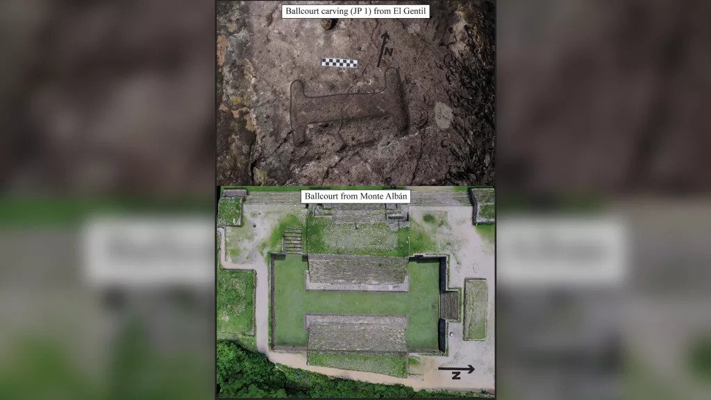
The image at the top shows one of the ballcourt carvings, its edges have been highlighted in the photo to make it easier to see. The image below shows a ballcourt at the site of Monte Alban, it is of a similar design to the carved ballcourt.
The carvings, in the ancient settlement of Quiechapa, are badly weathered, but small features in a few cases can be made out, such as one carving that appears to show a bench on the ballcourt.
“Ballgames were of great significance to people throughout ancient Mesoamerica,” study researcher Alex Elvis Badillo, an assistant professor in the Department of Earth and Environmental Systems at Indiana State University, wrote in an article published Jan. 11 in the journal Ancient Mesoamerica.
The shape of the ballcourts changed over time, and the rules of the ballgame are not known and may also have changed. The ballgame was played at least as early as 3,600 years ago, involved a rubber ball and two opposing sides, and was played from what is now the American Southwest, in Arizona and New Mexico, to as far south as Colombia in South America, Live Science previously reported. Much is still unknown about the ballgame but it appears to have held some level of religious and ceremonial importance scholars believe.
It’s unclear when exactly these carvings were crafted. Quiechapa dates back at least 2,300 years and possibly earlier, and people in southern Mexico began using I-shaped ballcourts around 2,100 years ago, Badillo told Live Science in an email, adding that “I think it is logical to suggest that these carvings would have been made sometime after [100 B.C.], however, it is hard to say when these carvings were made.”
The researchers found the 30 carvings in natural rock outcrops at two sites in the area. “This is the highest density in which this type of ballcourt representation occurs throughout Mesoamerica,” Badillo wrote in the study.
The biggest carving is 13.4 inches (34.1 centimeters) long while the shortest is 3.1 inches (8 cm) long, Badillo said. The archaeological team documented the carvings using structure-from-motion (SfM) photogrammetry. In this system, photos were taken of the carvings from different angles and uploaded to a computer program, which used the images and an algorithm to create a virtual, 3D representation of the carvings.
This image shows one of the ballcourt carvings after the photogrammetry process.
Bloodletting rituals
It’s not clear what the carvings were used for, but the researchers suggested that ancient Mesoamericans may have used them for rituals. The Spanish priest Juan Ruiz de Alarcón (lived 1581 to 1639), who lived in what is now Mexico following Spain’s conquest of the area in the 16th century, “describes certain rituals during which a [Mesoamerican] priest would have people spill blood into small cavities that they had made in stone,” Badillo wrote in the study, noting that those cavities could include the ballcourt carvings.
“The idea that water and blood are considered sacred and are symbols that are central to Mesoamerican cosmology is well established in the [scholarly] literature,” Badillo wrote in the paper.
“These seemingly inert stone carvings in Quiechapa’s landscape may have been part of deeply meaningful and active social performances that included ritual bloodletting for many possible purposes, including maintaining balance and agricultural fertility, marking important moments in time, or fomenting intra- and inter-community bonds,” Badillo wrote.
However, he cautioned that until more evidence is found, archaeologists can’t be certain that rituals were performed at these carvings.
Badillo presented the findings at the Society for American Archaeology (SAA) annual meeting held in Chicago from March 30 to April 3. The ballcourt carving surveys were carried out as part of the Quiechapa Archaeological Project (PAQuie).
3-D Photogrammetry Reveals 1,000-Year-Old Etchings in Alabama
Deep in a damp cave in northern Alabama, archaeologists have made a giant discovery. On a subterranean ceiling just half a meter high, researchers have uncovered the largest cave art discovered in North America: intricate etchings of humanlike figures and a serpent, carved by Native Americans more than 1000 years ago.
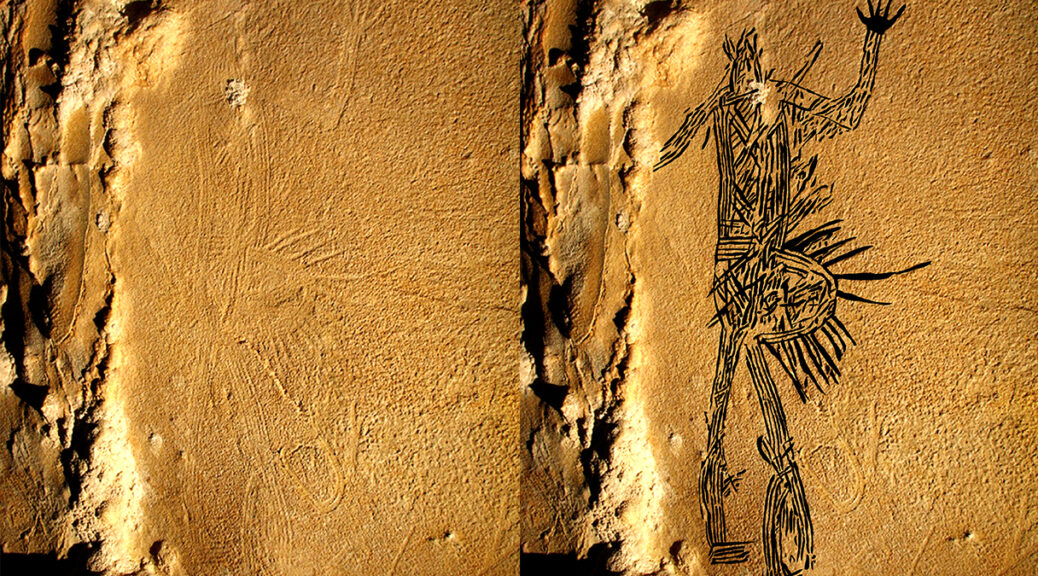
A humanlike figure was carved into the ceiling of 19th Unnamed Cave in Alabama (left), which archaeologists outlined virtually to make clearer (right).
“It’s exemplary and important work,” says Carla Klehm, an archaeologist at the University of Arkansas, Fayetteville (UAF).
Although the U.S. Southwest is famous for petroglyphs carved into canyons and cliff faces, much of the southeast’s rock art is hidden underground in caves. “Forty years ago, no one would have thought the southeast had much cave art,” says Thomas Pluckhahn, an archaeologist at the University of South Florida who wasn’t involved with the paper. But over the past few decades, archaeologists including the University of Tennessee, Knoxville’s Jan Simek have shown that’s not the case.
Simek first visited the 19th Unnamed Cave—called that in scientific papers so as to protect its precise location on private land—in the 1990s. In its cool, damp depths where no external light filters in, the flashlights of Simek and his colleagues revealed faint impressions on the ceiling depicting birds, snakes, wasps, and overlapping patterns of lines. The art resembled designs found on pottery in the southeast from the Woodland period, between 1000 B.C.E. and 1000 C.E.
The ceiling of the cave descends to just over half a meter high where the glyphs are located, so the researchers had to lie on their backs to see most of the images, Simek explains. There’s no place to stand and see the entire ceiling, he says.
Photographer Stephen Alvarez lights up the 19th Unnamed Cave in order to photograph its ceiling.
To get a more complete picture of the art, Simek revisited the cave in 2017 with Stephen Alvarez, a photographer and founder of the nonprofit Ancient Art Archive, which documents ancient rock art around the world and shares it online via virtual reality. Alvarez wanted to use a new technique called 3D photogrammetry to create a realistic 3D model of the cave—and see whether they could uncover additional images that had gone unobserved in the tight space.
The researchers climbed down into the cave and used a tripod to start taking photos. Over a period of 2 months, they took nearly 16,000 overlappings, and high-resolution images. Next, they stitched the photos together, using computer software to align the images in 3D space; researchers could then manipulate the resulting model using virtual reality software, Alvarez explains. “We could light the space any way we wanted and drop the floor away” to virtually step back and see the entire ceiling, he says.
As the researchers manipulated their images to make the drawings more visible, five huge glyphs that were previously too large and faint to be seen came into relief. They included three humanlike beings dressed in regal garments, a swirling figure with a rattlesnake like tail, and a long serpent with scales.
The images, likely made by etching into fresh mud on the damp ceiling, are undated. Charcoal fragments and wood smoke streaks on the cave walls, perhaps from the artists’ torches, date to the first millennium.
The Woodland Native Americans who lived in the area at that time resided in village settlements, built large earthen mounds for religious worship, and traded extensively across the south, east, and midwest. Their descendants remained in the region for centuries; but by the late 1800s, many had been forced west under the fledgling U.S. government’s policies of Native American removal.
The newly described figures share characteristics with other rock art formations in the southeast, like cliff drawings at Alabama’s Painted Bluff, and also in the Southwest, like the humanlike pictographs in Canyonlands National Park.
The figures are also similar to those found on Woodland-style pottery. Though the exact meaning of the glyphs is unclear, caves like the one in which they were found were often linked to the underworld, the researchers say.
While completing the work, the authors consulted with the Eastern Band of Cherokee Indians, whose tribal homeland includes the area where the cave is located.
Creating the glyphs required “an extraordinary degree of artistic skill” says UAF George Sabo. But much about the artists remains a mystery. “Who were they in their communities?” he wonders.
Though the cave’s location is undisclosed to protect the art from vandals, the team created a video from its model so anyone can explore it virtually. Klehm is excited to see 3D photogrammetry continue to reveal hidden art at other sites—and make it accessible. “[This] can help us see things that we can’t see, to go beyond what the human eye is used to looking for,” she says.
New research reveals how the black rat colonized Europe in the Roman and Medieval periods
New ancient DNA analysis has shed light on how the black rat, blamed for spreading Black Death, dispersed across Europe – revealing that the rodent colonized the continent on two occasions in the Roman and Medieval periods.
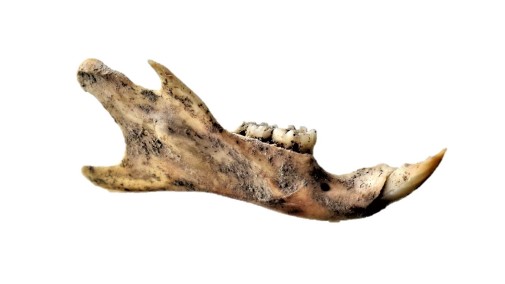
Archaeological black rat mandible.
The study – led by the University of York along with the University of Oxford and the Max Planck Institute – is the first ancient genetic study of the species (Rattus rattus), often known as the ship rat.
By analyzing DNA from ancient black rat remains found at archaeological sites spanning the 1st to the 17th centuries in Europe and North Africa, the researchers have pieced together a new understanding of how rat populations dispersed following the ebbs and flows of human trade, urbanism, and empires.
Disappearance
The study shows that the black rat colonized Europe at least twice, once with the Roman expansion and then again in the Medieval period – matching up with archaeological evidence for a decline or even disappearance of rats after the fall of the Roman Empire.
The authors of the study say this was likely related to the break-up of the Roman economic system, though climatic change and the 6th Century Justinianic Plague may have played a role too. When towns and long-range trade re-emerged in the Medieval period, so too did a new wave of black rats.
The black rat is one of three rodent species, along with the house mouse (Mus musculus) and the brown rat (Rattus norvegicus), to have become globally distributed as a result of its ability to live around humans by taking advantage of food and transportation.
Competition
Black rats were widespread across Europe until at least the 18th century, before their population declined, most likely as a result of competition with the newly arrived brown rat (Rattus norvegicus), the now dominant rat species in temperate Europe.
Dr. David Orton from the Department of Archaeology said: “We’ve long known that the spread of rats is linked to human events, and we suspected that Roman expansion brought them north into Europe.
“But one remarkable result of our study is quite how much of a single event this seems to have been: all of our Roman rat bones from England to Serbia form a single group in genetic terms.”
“When rats reappear in the Medieval period we see a completely different genetic signature – but again all of our samples from England to Hungary to Finland all group together. We couldn’t have hoped for clearer evidence of repeated colonization of Europe.”
Signature
Alex Jamieson, a co-author at the University of Oxford, said “The modern dominance of brown rats has obscured the fascinating history of black rats in Europe. Generating genetic signatures of these ancient black rats reveals how closely black rat and human population dynamics mirror each other.”
He Yu, the co-author from the Max Planck Institute, said “This study is a great showcase of how the genetic background of human commensal species, like the black rat, could reflect historical or economic events. And more attention should be paid to these often neglected small animals.”
Flourish
The study could also be used to provide information about human movement across continents, the researchers say.
Dr. Orton added: “Our results show how human-commensal species like the black rat, animals which flourish around human settlements, can act as ideal proxies for human historical processes”.
The research was a collaboration between York and partners including Oxford, the Max Planck Institute, and researchers in over 20 countries.
Defiant message discovered in Cuban Missile Crisis bunker
Sixty years ago during the Cuban Missile Crisis, a defiant individual — likely a Cuban soldier — wrote a message in a system of bunkers and trenches on the Cuban coast declaring that surrender was not in the cards, new research finds.
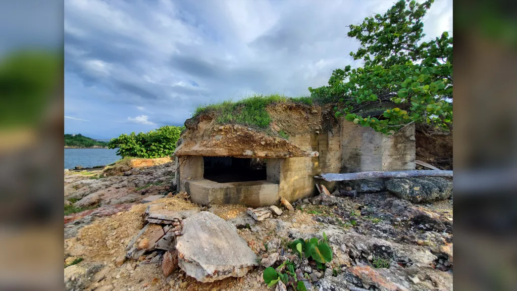
This photo shows a bunker that was built to defend the island in case the Americans invaded during the Cuban Missile Crisis.
Archaeologists discovered the graffiti while documenting the remains of these bunkers and trenches, which Cuba prepared in case the United States invaded the island during the 1962 Cuban Missile Crisis — a 13-day standoff that brought the world to the brink of nuclear war.
The individual’s message, written in Spanish, indicates that they were determined to fight in the event of war breaking out.
Another photo of a bunker. The Cuban Missile Crisis brought the world to the brink of nuclear war.
The bunkers and trenches combined with storage areas formed an interconnected system of fortifications.
The crisis, which occurred in October 1962 during the Cold War, flared up when the Soviet Union placed nuclear missiles on communist-controlled Cuba — about 124 miles (200 kilometers) from the U.S. coast.
The United States responded by blockading the Caribbean island and threatening to invade it if the nuclear weapons were not removed — bringing the two nuclear superpowers close to World War III.
An agreement was eventually reached in which the Soviet Union withdrew nuclear missiles from Cuba in exchange for the United States removing nuclear missiles from Turkey.
While the United States did not launch a full-scale invasion of Cuba, the system of bunkers and trenches that were built to defend the island still remains.
Some of the people stationed in these fortifications left defiant messages on the walls. “Some inscriptions relating to the time of the Missile Crisis are very interesting, including one that reads: ‘aquí no se rinde nadie’ (no one is giving up here),” Odlanyer Hernández de Lara, a doctoral candidate in archaeology at the Maxwell School of Citizenship and Public Affairs of Syracuse University in New York, told Live Science in an email.
Archaeologists are documenting these Cold War defenses using 3D photogrammetry — a technique in which a multitude of digital photos are taken of an object and then processed by software to create a digital 3D model.
The system of bunkers and trenches formed an interconnected system of fortifications designed to stop American troops from landing in Cuba.
“These bunkers are concrete structures with a main and an elevated/secondary embrasure [opening] facing the sea, and a main rear entrance with two alternative exits to the sides,” de Lara said. “The trenches are excavated into bedrock, connecting the bunkers with [a] storage area.”
Some of the bunkers and trenches are in good shape, but others have been damaged by coastal erosion or other effects due to the passage of time, de Lara said.
The Cuban military stopped using them sometime after the missile crisis and they are now abandoned.
The research, which is not yet published in a peer-reviewed journal, was presented at the annual meeting of the Society for American Archaeology (SAA) that was held in Chicago from March 30 to April 3.
The SAA paper was co-authored by Esteban Grau González-Quevedo, a researcher at the Antonio Núñez Jiménez Foundation for Nature and Humanity (FANJ), a scientific institution in Cuba.
First-ever portrait of Jesus found in 1 of 70 ancient books?
The image is eerily familiar: a bearded young man with flowing curly hair. After lying for nearly 2,000 years hidden in a cave in the Holy Land, the fine detail is difficult to determine. But in a certain light, it is not difficult to interpret the marks around the figure’s brow as a crown of thorns. The extraordinary picture of one of the recently discovered hoards of up to 70 lead codices – booklets – found in a cave in the hills overlooking the Sea of Galilee is one reason Bible historians are clamouring to get their hands on the ancient artefacts. If genuine, this could be the first-ever portrait of Jesus Christ, possibly even created in the lifetime of those who knew him. The tiny booklet, a little smaller than a modern credit card, is sealed on all sides and has a three-dimensional representation of a human head on both the front and the back. One appears to have a beard and the other is without. Even the maker’s fingerprint can be seen in the lead impression. Beneath both figures is a line of as-yet undeciphered text in an ancient Hebrew script.
Discovery: The impression on this booklet cover shows what could be the earliest image of Christ
Astonishingly, one of the booklets appears to bear the words ‘Saviour of Israel’ – one of the few phrases so far translated. The owner of the cache is Bedouin trucker Hassan Saida who lives in the Arab village of Umm al-Ghanim, Shibli. He has refused to sell the booklets but two samples were sent to England and Switzerland for testing.
A Mail on Sunday investigation has revealed that the artefacts were originally found in a cave in the village of Saham in Jordan, close to where Israel, Jordan and Syria’s Golan Heights converge – and within three miles of the Israeli spa and hot springs of Hamat Gader, a religious site for thousands of years.
Precious: This booklet shows what scholars believe to be the map of Christian Jerusalem
According to sources in Saham, they were discovered five years ago after a flash flood scoured away the dusty mountain soil to reveal what looked like a large capstone. When this was levered aside, a cave was discovered with a large number of small niches set into the walls. Each of these niches contained a booklet. There were also other objects, including some metal plates and rolled lead scrolls. The area is renowned as an age-old refuge for ancient Jews fleeing the bloody aftermath of a series of revolts against the Roman empire in the First and early Second Century AD. The cave is less than 100 miles from Qumran, where the Dead Sea Scrolls were discovered, and around 60 miles from Masada, the scene of the last stand and mass suicide of an extremist Zealot sect in the face of a Roman Army siege in 72AD – two years after the destruction of the Second Temple in Jerusalem. It is also close to caves that have been used as sanctuaries by refugees from the Bar Kokhba revolt, the third and final Jewish revolt against the Roman Empire in 132AD.
The era is of critical importance to Biblical scholars because it encompasses the political, social and religious upheavals that led to the split between Judaism and Christianity. It ended with the triumph of Christianity over its rivals as the dominant new religion first for dissident Jews and then for Gentiles. In this context, it is important that while the Dead Sea Scrolls are rolled pieces of parchment or papyrus containing the earliest-known versions of books of the Hebrew Bible and other texts – the traditional Jewish format for written work – these lead discoveries are in the book, or codex, form which has long been associated with the rise of Christianity.
The codices are seen by The Mail on Sunday range in size from smaller than 3in x 2 to around 10in x 8in. They each contain an average of eight or nine pages and appear to be cast, rather than inscribed, with images on both sides and bound with lead-ring bindings. Many of them were severely corroded when they were first discovered, although it has been possible to open them with care. The codex showing what may be the face of Christ is not thought to have been opened yet. Some codices show signs of having been buried – although this could simply be the detritus resulting from lying in a cave for hundreds of years. Unlike the Dead Sea Scrolls, the lead codices appear to consist of stylised pictures, rather than text, with a relatively small amount of script that appears to be in a Phoenician language, although the exact dialect is yet to be identified. At the time these codices were created, the Holy Land was populated by different sects, including Essenes, Samaritans, Pharisees, Sadducees, Dositheans and Nazoreans.
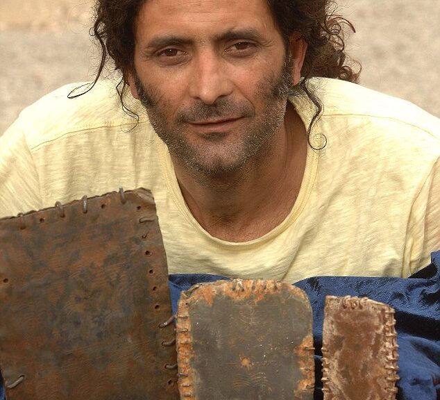
One lucky owner: Hassan Saida with some of the artefacts that he says he inherited
There was no common script and considerable intermingling of language and writing systems between groups. This means it could take years of detailed scholarship to accurately interpret the codices. Many of the books are sealed on all sides with metal rings, suggesting they were not intended to be opened. This could be because they contained holy words which should never be read. For example, the early Jews fiercely protected the sacred name of God, which was only ever uttered by The High Priest in the Temple in Jerusalem at Yom Kippur. The original pronunciation has been lost, but has been transcribed into Roman letters as YHWH – known as the Tetragrammaton – and is usually translated either as Yahweh or Jehovah. A sealed book containing sacred information was mentioned in the biblical Book of Revelations.
One plate has been interpreted as a schematic map of Christian Jerusalem showing the Roman crosses outside the city walls. At the top can be seen a ladder-type shape. This is thought to be a balustrade mentioned in a biblical description of the Temple in Jerusalem. Below that are three groups of brickwork, to represent the walls of the city. A fruiting palm tree suggests the House of David and there are three or four shapes that appear to be horizontal lines intersected by short vertical lines from below. These are the T-shaped crosses believed to have been used in biblical times (the familiar crucifix shape is said to date from the 4th Century). The star shapes in a long line represent the House of Jesse – and then the pattern is repeated.
This interpretation of the books as proto-Christian artefacts is supported by Margaret Barker, former president of the Society for Old Testament Study and one of Britain’s leading experts on early Christianity. The fact that a figure is portrayed would appear to rule out these codices being connected to mainstream Judaism of the time, where the portrayal of lifelike figures was strictly forbidden because it was considered idolatry. If genuine, it seems clear that these books were, in fact, created by an early Messianic Jewish sect, perhaps closely allied to the early Christian church and that these images represent Christ himself. However another theory, put forward by Robert Feather – an authority on The Dead Sea Scrolls and author of The Mystery Of The Copper Scroll Of Qumran – is that these books are connected to the Bar Kokhba Revolt of 132-136AD, the third major rebellion by the Jews of Judea Province and the last of the Jewish-Roman Wars.
The revolt established an independent state of Israel over parts of Judea for two years before the Roman army finally crushed it, with the result that all Jews, including the early Christians, were barred from Jerusalem. The followers of Simon Bar Kokhba, the commander of the revolt, acclaimed him as a Messiah, a heroic figure who could restore Israel. Although Jewish Christians hailed Jesus as the Messiah and did not support Bar Kokhba, they were barred from Jerusalem along with the rest of the Jews. The war and its aftermath helped differentiate Christianity as a religion distinct from Judaism.
Wonder: The cave in Jordan where the metal books were discovered
The spiritual leader of the revolt was Rabbi Shimon Bar Yochai, who laid the foundations for a mystical form of Judaism known today as Kabbalah, which is followed by Madonna, Britney Spears and others. Yochai hid in a cave for 13 years and wrote a secret commentary on the Bible, the Zohar, which evolved into the teaching of Kabbalah. Feather is convinced that some of the text on
The codices carry the name of Rabbi Bar Yochai.
Feather says that all known codices prior to around 400AD were made of parchment and that cast lead is unknown. They were clearly designed to exist forever and never to be opened. The use of metal as a writing material at this time is well documented – however, the text was always inscribed, not cast.
The books are currently in the possession of Hassan Saida, in Umm al-Ghanim, Shibli, which is at the foot of Mount Tabor, 18 miles west of the Sea of Galilee. Saida owns and operates a haulage business consisting of at least nine large flatbed lorries. He is regarded in his village as a wealthy man. His grandfather settled there more than 50 years ago and his mother and four brothers still live there. Saida, who is in his mid-30s and married with five or six children, claims he inherited the booklets from his grandfather. However, The Mail on Sunday has learned of claims that they first came to light five years ago when his Bedouin business partner met a villager in Jordan who said he had some ancient artefacts to sell. The business partner was apparently shown two very small metal books. He brought them back over the border to Israel and Saida became entranced by them, coming to believe they had magical properties and that it was his fate to collect as many as he could. The arid, mountainous area where they were found is both militarily sensitive and agriculturally poor. The local people have for generations supplemented their income by hoarding and selling archaeological artefacts found in caves.
More of the booklets were clandestinely smuggled across the border by drivers working for Saida – the smaller ones were typically worn openly as charms hanging from chains around the drivers’ necks, the larger concealed behind car and lorry dashboards. In order to finance the purchase of booklets from the Jordanians who had initially discovered them, Saida allegedly went into partnership with a number of other people – including his lawyer from Haifa, Israel. Saida’s motives are complex. He constantly studies the booklets but does not take particularly good care of them, opening some and coating them in olive oil in order to ‘preserve’ them.
Masterpiece: Later versions of Christ, including Leonardo Da Vinci’s interpretation in his fresco The Last Supper, give Jesus similar characteristics
The artefacts have been seen by multi-millionaire collectors of antiquities in both Israel and Europe – and Saida has been offered tens of millions of pounds for just a few of them, but has declined to sell any. When he first obtained the booklets, he had no idea what they were or even if they were genuine. He contacted Sotheby’s in London in 2007 in an attempt to find an expert opinion, but the famous auction house declined to handle them because their provenance was not known.
Soon afterwards, the British author and journalist Nick Fielding was approached by a Palestinian woman who was concerned that the booklets would be sold on the black market. Fielding was asked to approach the British Museum, the Fitzwilliam Museum in Cambridge and other places. Fielding travelled to Israel and obtained a letter from the Israeli Antiquities Authority saying it had no objection to their being taken abroad for analysis. It appears the IAA believed the booklets were forgeries on the basis that nothing like them had been discovered before.
None of the museums wanted to get involved, again because of concerns over provenance. Fielding was then asked to approach experts to find out what they were and if they were genuine. David Feather, who is a metallurgist as well as an expert on the Dead Sea Scrolls, recommended submitting the samples for metal analysis at Oxford University. The work was carried out by Dr Peter Northover, head of the Materials Science-based Archaeology Group and a world expert on the analysis of ancient metal materials. The samples were then sent to the Swiss National Materials Laboratory at Dubendorf, Switzerland. The results show they were consistent with ancient (Roman) period lead production and that the metal was smelted from ore that originated in the Mediterranean. Dr Northover also said that corrosion on the books was unlikely to be modern.
Meanwhile, the politics surrounding the provenance of the books is intensifying. Most professional scholars are cautious pending further research and point to the ongoing forgery trial in Israel over the ancient limestone ossuary purporting to have housed the bones of James, brother of Jesus. The Israeli archaeological establishment has sought to defuse problems of provenance by casting doubt on the authenticity of the codices, but Jordan says it will ‘exert all efforts at every level’ to get the relics repatriated. The debate over whether these booklets are genuine and, if so, whether they represent the first known artefacts of the early Christian church or the first stirrings of mystical Kabbalah will undoubtedly rage for years to come.
The director of Jordan’s Department of Antiquities, Ziad Al-Saad, has few doubts. He believes they may indeed have been made by followers of Jesus in the few decades immediately following his crucifixion.
‘They will really match, and perhaps be more significant than, the Dead Sea Scrolls,’ he says. ‘The initial information is very encouraging and it seems that we are looking at a very important and significant discovery – maybe the most important discovery in the history of archaeology.’
If he is right, then we really may be gazing at the face of Jesus Christ.
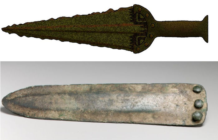
Tests Indicate Bronze Age Daggers Had a Practical Purpose
Analysis of Bronze Age daggers has shown that they were used for processing animal carcasses and not as non-functional symbols of identity and status, as previously thought.
One of the experimental daggers.
This is a significant breakthrough as the new method enables the analysis of a wide variety of copper-alloy tools and weapons from anywhere in the world.
Professor Andrea Dolfini
First appearing in the early 4th millennium BCE, copper-alloy daggers were widespread in Bronze Age Europe including Britain and Ireland. Yet archaeologists have long debated what these objects were used for.
As daggers are often found in weapon-rich male burials or ‘warrior graves, many researchers speculated that they were primarily ceremonial objects used in prehistoric funerals to mark out the identity and status of the deceased. Others suggested that they may have been used as weapons or tools for crafts.
However, the lack of a targeted method of analysis for copper-alloy metals, like those available for ceramic, stone, and shell artefacts, left this problem unresolved.
A revolutionary new method, pioneered by an international research team led by Newcastle University, UK, has enabled the world’s first extraction of organic residues from ten copper-alloy daggers excavated in 2017 from Pragatto, a Bronze Age settlement site in Italy.
The new method reveals, for the first time, how these objects were used, for what tasks, and on what materials.
The project team, led by Professor Andrea Dolfini and Isabella Caricola, developed a technique that used Picro-Sirius Red (PSR) solution to stain organic residues on the daggers.
The residues were then observed under several types of optical, digital, and scanning electron microscopes. This allowed the team to identify micro-residues of collagen and associated bone, muscle, and bundle tendon fibres, suggesting that the daggers had come into contact with multiple animal tissues and were used to process various types of animal carcasses. Uses seem to have included the slaughtering of livestock, butchering carcasses, and carving the meat from the bone.
The EU-funded project team then carried out wide-ranging experiments with replicas of the daggers that had been created by an expert bronzesmith. This showed that this type of dagger was well suited to processing animal carcasses.
The residues extracted from the experimental daggers were also analysed as part of the research and matched those observed on the archaeological daggers.
Professor Andrea Dolfini, Chair of Archaeology, Newcastle University, said: “The research has revealed that it is possible to extract and characterise organic residues from ancient metals, extending the range of materials that can be analysed in this way.
This is a significant breakthrough as the new method enables the analysis of a wide variety of copper-alloy tools and weapons from anywhere in the world.
The possibilities are endless, and so are the answers that the new method can and will provide in the future.