The underwater city of Cuba- is this the lost city of Atlantis

The underwater city of Cuba- is this the lost city of Atlantis

Back in 2001, Pauline Zalitzki and her husband Paul Weinzweig came upon one of the most impressive discoveries of the 21st Century. While working on a survey mission with the Cuban Government she stumbled upon an interesting reading while exploring the coast of the Guanahacabibes Peninsula in the Pinar Del Rio Province of Cuba.

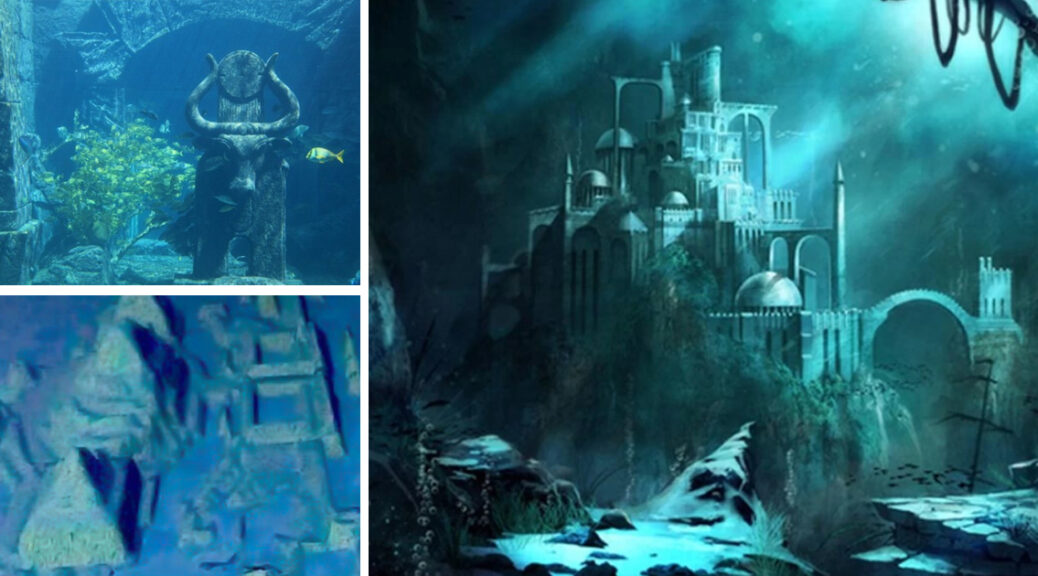
The structures appeared completely analogous against the barren ‘desert’ of the ocean floor and seemed to show symmetrically organized stones reminiscent of urban development. A media flurry soon ensued with news sites sporting headlines such as ‘Atlantis Discovered in Cuba’ and ‘Lost the City of the Caribbean Found’.

However, the finding also attracted the attention of the government, national museum, and national geographic, who all made promises to investigate the strange sonar images.  Now, ten years on, the story has disappeared into obscurity. Whatever happened to the sunken ‘ruins’ of Cuba? Were they ever fully investigated? And why has the media fallen silent on this unusual discovery? It is very enticing, and for the traveler, they may want to go to Cuba and see if they can explore it first hand. They will want to click here for some tips if they do decide to take that journey.

ADC was one of four firms working in a joint venture with President Fidel Castro’s government to explore Cuban waters, which hold hundreds of treasure-laden ships from the Spanish colonial era.

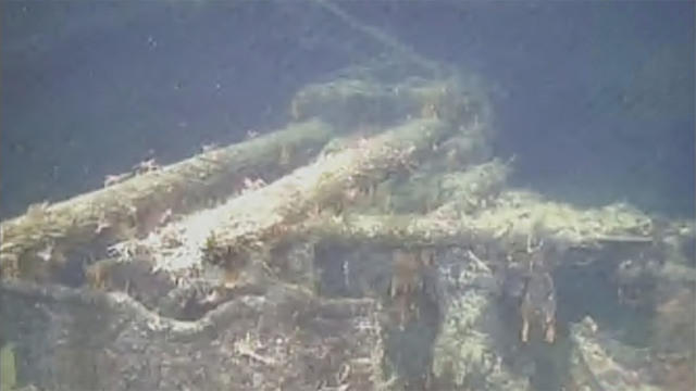
The team was using advanced sonar equipment to scan a 2 square kilometer area of the seafloor when they noticed a series of symmetrical and geometric stone structures resembling an urban complex.

Map showing location of supposed ancient city discovered by Paul Weinzweig and Pauline Zalitzki.

Upon studying the sonar images, Zalitzki observed what appeared to be unusual formations of smooth blocks, crests, and geometric shapes. Some of the blocks looked like they were built in pyramid shapes, others were circular. 

In July 2001, they returned to the site with geologist Manuel Iturralde, senior researcher of Cuba’s Natural History Museum, this time equipped with a Remotely Operated Vehicle to examine and film the structures.

The images revealed large blocks of stone resembling hewn granite, measuring about 8 feet by 10 feet. Some blocks appeared deliberately stacked atop one another, others appeared isolated from the rest. Zalitzki said that the images appeared to reflect the ruins of a submerged city but were reluctant to draw any conclusions without further evidence.

“These are extremely peculiar structures, and they have captured our imagination,” said Iturralde, who has studied countless underwater formations. “But if I had to explain this geologically, I would have a hard time.”

Estimating that it would have taken 50,000 years for such structures to have sunken to the depth at which they were said to be found, Iturralde added “50,000 years ago there wasn’t the architectural capacity in any of the cultures we know of to build complex buildings.”

A specialist in underwater archaeology at Florida State University added “It would be cool if they were right, but it would be real advanced for anything we would see in the New World for that time frame. The structures are out of time and out of place.”

In the media storm that followed the announcement of the discovery, news sites were quick to draw parallels with the fabled lost city of Atlantis. However, Zelitsky and Weinzweig were unwilling to make such comparisons.  The story is a myth, said Zelitsky.

“What we have found is more likely remnants of local culture,” once located on a 100-mile “land bridge” that joined Mexico’s Yucatan Peninsula with Cuba.  Iturralde added that there are local legends of the Maya and native Yucatecos that tell of an island inhabited by their ancestors that vanished beneath the waves. Nevertheless, Iturralde does not discount the possibility that the rock formations are merely the result of the wonders of Mother Nature. “Nature is able to create some really unimaginable structures,” he said.

Despite hundreds of media outlets reporting on sunken cities, advanced civilizations, the lost city of Atlantis, and submerged ruins, there are others who are not so willing to accept this point of view. 

Keith Fitzpatrick-Matthews from the debunking website Bad Archaeology claimed that the depth of the alleged remains is the biggest problem for the sunken city proponents. During the Pleistocene, which was characterized by a series of ice ages, sea levels dropped significantly, but the maximum drop was around 100 meters.

“At no point during the Ice Age would it have been above sea level unless, of course, the land on which they stand has sunk. This is the claim made for Atlantis: according to Plato’s account, it was destroyed “by violent earthquakes and floods”. However, if we take Plato at his word – as we must if we assume Atlantis to have been a historical place – the violence of its sinking makes it improbable that an entire city could have survived to plunge more than 600 m into an abyss,” writes Fitzpatrick-Matthews.

If we assume that he is right and that these stone structures do not reflect an ancient submerged city but are simply products of nature, then surely geologists and other scientists would be quick to jump on the finding and investigate what freakish event of nature caused such peculiar formations. 

Strangely, however, there have been no reported follow-up investigations and news outlets have gone deathly silent on the matter. What happened to all the promises from the government, national museum, National Geographic, and other scientists to carry out further surveys?

The quick dismissal of the story has led some to question whether there has been a suppression of information regarding the finding. However, Fitzpatrick-Matthews claims the story simply went cold and that in the end experts were not convinced that Zelitsky had really discovered a sunken city.
Archaeologists Found 12th Century Medieval Castle in England

Archaeologists Found 12th Century Medieval Castle in England

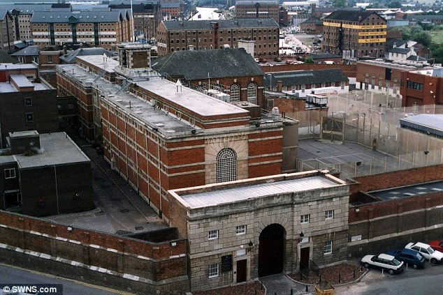
The greatest archeological and historical discoveries are often found in the most unlikely of places. This was the case in December, when construction laborers were left in awe while renovating a men’s prison in Gloucester, England.

Back around the year 1110, the rulers of Gloucester built an impressive castle ”similar to the Tower of London,” It had 3 chapels, 2 drawbridges, and walls that were a solid 12 feet wide. 

During the 15th century reign of Richard III (the hunchback ruler with a bad reputation who was recently found buried under a parking lot), the castle became a country jail.

For the next 200 years or so, it served as a makeshift lockup until, in 1787, it was knocked down to make way for a dedicated Jail. This prison, which closed in 2013 after many updates to the buildings, is now in the process of being renovated.

When the old basketball court was dug up, an archaeological group found a wall from the original castle just two feet beneath the ground. It’s not clear yet what this discovery means for the future of the site.

It was slated for redevelopment of some sort, but as one local planner told the Gloucester Citizen, “you can not just ignore that there is a castle there.”

Intending to tear down and replace the old facility, the team was forced to halt the project when they unearthed pieces of near ancient history. So just what, exactly, was down there? Would you believe it was a medieval castle?

They believe the castle was built between 1110 and 1120, and “was a large structure, with the keep, which we have now located in our work, an inner bailey and stable.

While Digging in the Excercise yard of a defunct jail, construction workers in Gloucester, England, unexpectedly unearthed a castle wall from the 12th century.

The keep was surrounded by a series of concentric defences which comprised curtain walls and ditches, with the drawbridge and gatehouse lying outside the current site toward the north.”

The keep is believed to have been 30 metres in length and 20 metres wide, and had walls as thick as 12 feet. Neil Holbrook, chief executive of Cotswold Archaeology, told the Western Press Daily, “I am surprised by what we Discovered.

I knew there was a castle however I had expected more of it to have been destroyed.” He added the size and design would have been similar to the Tower of London.

“It would have been a powerful symbol of Norman architecture engineering,” he said. “As you came to Gloucester you would have seen the cathedral and the castle, which is representative of how important the city was in Norman Britain.” 

The archaeologists have so far discovered nearly 900 objects, including medieval pottery and a 6-sided die made of bone. It was believed that the castle had been destroyed in the eighteenth century when a prison was built on the site, however, it seems that the gaol was built over the medieval structure.

 The jail was in use until 2013 and is set for redevelopment. News of the discovery is leading to calls that the site is protected. Paul James, Leader of Gloucester City Council explained to the Gloucester Citizen, “Whatever is done on-site needs to be sensitive to the heritage of both the castle and the listed buildings there.

We are blessed that we have a designer that cares about the heritage of the site. Having glass flooring above it, allowing visitors to see through might be a possibility. The most important matter is to preserve it well, the walls have been here for many years and we want them here for hundreds more.”

20,000 years old Dogs remains Found in Caves in Southern Italy

20,000 years old Dogs remains Found in Caves in Southern Italy

The Jacksonville Free Press reports that dog remains found in two caves in Apulia have been dated to between 20,000 and 14,000 years ago. The dogs are thought to have inhabited the caves with humans, pushing back dog domestication in the region by about 4,000 years. 

The causes of this phenomenon are still a complete mystery, while dogs are recognized as the best companion of humanity and one of the most domesticated animals worldwide.

Researchers from the University of Siena in Italy hope their discovery can shed light on how dogs made the change from wild carnivores to loving companions. 

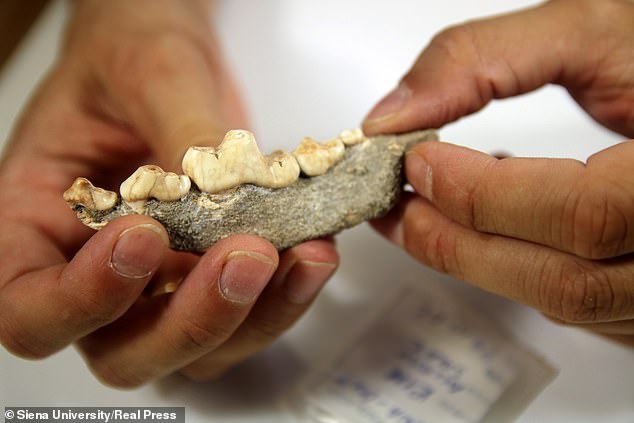
The difference between dog remains found at the prehistoric cave of Grotta Paglicci (the smaller one) and the same anatomic element from a current wolf.
This jaw bone comes from the cave of Grotta Paglicci shows how the teeth of what could be Europe’s earliest domesticated dogs

One theory is that wolves became scavengers out of necessity due to a lack of food, and this took them close to human settlements.  Some experts believe the animals and humans slowly developed a bond and the symbiotic relationship flourished from there. 

Others think wolves and humans worked together when hunting and this is how the relationship spawned.  The research team from Siena University hopes that the surviving fragments of one of the first dogs to live alongside humans as a pet could help find a definitive answer. 

Dr. Francesco Boschin led a piece of research, published in August in Scientific Reports, on early canine remains found at two paleolithic caves in Southern Italy, the Paglicci Cave, and the Romanelli Cave.

Writing in this study, the scientists say: ‘Our combined molecular and morphological analyses of fossil canid remain from the sites of Grotta Paglicci and Grotta Romanelli, in southern Italy, attest of the presence of dogs at least 14,000 calibrated years before present. 

‘This unambiguously documents one of the earliest occurrences of domesticates in the Upper Palaeolithic of Europe and in the Mediterranean.’ However, a further analysis which is still ongoing shows this figure could indeed be much later, towards 20,000 years, Dr Boschin told RealPress.   

‘From an archaeological point of view, the oldest remains of domesticated dogs were found in Central Europe and date back 16,000 years,’ Dr Boschin said.   

In the Mediterranean area, we have now established that domesticated dogs lived here 14,000 years ago for sure, but possibly even 20,000 years ago. While defining their true age is still a work in progress, the researchers are confident of one thing, their findings include the oldest pet dog specimens discovered in the Mediterranean area.

‘[They] could also represent the until now missing evidence of the evolutionary process that led to the dog, the very first domesticated animal,’ Dr. Boschin adds. Remains of wolves were also discovered in the caves. They were bigger than the dogs and had distinct molars designed to tear meat apart that dogs do not have. 

Paglicci cave italy.

Molecular analysis has indicated that the genetic separation of wolves and dogs started somewhere between 20,000 and 30,000 years ago, and according to Dr. Boschin, the domestication process itself may have played a key part in that process. We believe that in the first stage of the domestication process it is always like that – domesticated animals are always smaller than wild ones,’ he said.

‘This is true for all mammals. In the case of dogs, we consider them to be pets, and this is the first evidence: Their smaller size.’

Scholars and scientists agree that the domestication of the dog dates back to the Last Glacial Maximum, a period of strong environmental crisis during which many European animal populations – and humans – sought refuge in warmer regions, such as the peninsulas of southern Europe, including Italy, Iberia and the Balkans.

Difference between the dog of Grotta Paglicci (the smaller one) and the same bone from a current wolf. On the table are other two remains of Grotta Paglicci (vertebrae and a jaw
Professor Caramelli (left), of the Florence University, seeing the difference between a dog from Paglicci and a current wolf in the lab of anthropology of the university

‘In this period of serious crisis, the wolf, a social predator in some way similar to man, found a new way to ensure survival: taking advantage of a new niche, eating the leftovers from human settlements,’ Dr. Boschin explained.  He also believes it is possible humans tried to accelerate the divergence from wolf to dog by killing the most aggressive offspring, encouraging calm and obedient genes to be passed down the generations. 

The genetic profile from one of the dogs discovered in the Paglicci Cave closely resembles the genetic profile of similar remains found in Germany. Both of these findings could be dated to about 14,000 years ago.

This, Dr. Boschin said, shows that the specimens found more than 600 miles apart both originated from a common population before spreading across Europe. 

‘At that time our continent was characterized by a strong cultural fragmentation, but the discovery of two genetically related dogs, one in southern Italy and the other in Germany, suggests that, despite cultural differences, the dogs may have represented a common cultural feature among human groups.’

The research could lead to a better understanding of the role dogs played in Palaeolithic communities, something we still know next to nothing about. 

Dogs may have had a specific function in the hunting or in the defence of camps. They may also have served a more spiritual purpose, as dogs still do today in some tribal cultures, where they are considered reincarnations of the dead or earthly manifestations of spirits.

The research team is still analyzing the findings and hope to eventually be able to provide more answers to this and other questions about the early co-existence of man and his best friend, Dr Boschin said. 

Massive Lion Sculpture Uncovered in Cambodia

Massive Lion Sculpture Uncovered in Cambodia

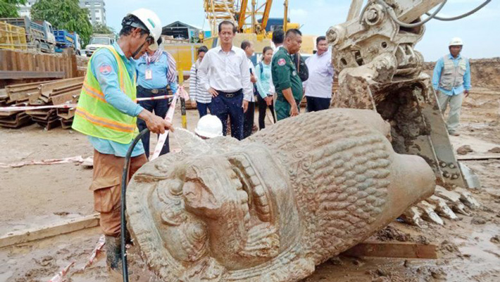
According to a report in The Phnom Penh Post, two pieces of a six-foot-tall statue of a lion were unearthed by mine-clearing experts preparing the site of a new groundwater reservoir along the Tonle Sap River.

The crew members excavated and cleared mines for a planned groundwater reservoir that will also be the site of Phnom Penh’s sixth water pumping station. It is located along the Tonle Sap River in front of the Council for the Development of Cambodia, according to Ratana.

After digging the soil up to 4 m underground lion statue was discovered, separated into two parts. At the National Museum, the Ministry will retain it, “he added.

A statue of a lion was found by mine clearance experts while they were digging for a development project along the Tonle Sap River in Phnom Penh’s Daun Penh district. CMAC

Ratana said it is not CMAC’s duty to care for the statue, so the organization will leave it to the proper authorities to preserve it.

The director-general for tangible heritage at the ministry, Hab Touch, told The Post on Tuesday that he had not seen the statue yet. A press release he received said the statue resembles the lion statue at Wat Phnom.

But Touch said: “I don’t think it’s a lion from Wat Phnom because that lion is large. Its location means there must be something there like a bridge.”

Phnom Penh Department of Culture director Chum Vuthy told The Post on Tuesday that the ministry hasn’t studied the statue yet.

“This matter should be brought to the museum and the Ministry of Culture and Fine Arts, which took this statue to study it. There is an experiment center in the museum,” he said.

National Museum director Chhay Visoth told The Post that he cannot make any assumptions about which era the stone lion was made in because experts needed time to check the composition of the ancient stone.

“We cannot make assumptions of the lion that we found during mine clearance for the reservoir plan because we don’t have any connections regarding this statue.

“Normally, we can know the date of an artefact by identifying other things around it,” he said.

Viosth said it’s suspected that the lion was created at the same time as Wat Phnom or sometime after Cambodia was a French protectorate.

He said the statue also could have been taken from other areas such as Angkor.

“We suspect that it could have been from the Bakheng Mountain area because its height is 2m. We need time to study and date it,” he said.

Roman Settlement Unearthed in Eastern England

Roman Settlement Unearthed in Eastern England

Excavation ahead of road construction in the East Midlands has uncovered human remains, animal bones, roof tiles, an iron sickle, a copper spoon handle, brooches, stone walls, a pottery kiln, and other furnaces and ovens dated to the second or third centuries A.D., according to a Lincolnshire Live report.

Some 400 Roman coins were also recovered. One of the buildings unearthed at the site was built into a hillside. The remains of several adults, including at least eight new-born babies who died in the second or third centuries AD, were found at the site near Grantham.

Overall, thousands of long-forgotten artifacts have been unearthed as part of ongoing works on the Grantham Southern Relief Road.

An aerial view of one of the buildings

Catherine Edwards, project manager for AOC Archaeology – the firm contracted to research the site’s archaeology – said: “Although the finds are yet to be looked at by specialists, we believe the oldest activity dates back to the Romano-British period, somewhere between 100 and 410 AD.

“The first step of our investigation was to carefully strip the site’s topsoil. Once the material was moved off-site, we were able to move in and start our investigations.

“First, we used a range of heavy tools, like shovels, spades, picks and barrows, to expose features and artefacts.

“We then used lighter hand tools, like trowels and hand brushes, to excavate and clean what we’d uncovered.

“A full written record of each feature or layer is then produced, describing its function, form and relationships with other features.

“Each discovery is also photographed, and GPS equipment is used to locate each one accurately on a plan.

“This allows us to ‘recreate’ the site and tell its story.”

The three biggest finds

According to Phil Weston, senior archaeological consultant at WSP – the company advising Lincolnshire County Council on highway design and environmental compliance – the three most significant finds discovered as part of this investigation are:

Several exceptionally well-preserved Roman buildings – one building was terraced into the hillside and officials believe that a landslip caused it to collapse.

“The remarkable preservation of this building and several others will help the archaeologists in reconstructing the buildings and the lives of those that used them.”

The buildings have been discovered as part of the works

Burials – as well as a grave containing the remains of several adults, the remains of at least eight new-born babies who died in the second or third centuries AD were found buried under the floors and foundations of some of the buildings.

The grave of an adult

Phil said: “Such burials are not uncommon on Roman sites and they are referred to as foundation burials.

“No one knows for sure why, but one idea is that they were thought to bring luck to the structure and its occupants.”

Industrial features – a very well-preserved pottery kiln and several other furnace/oven bases were uncovered.

The base of an oven furnace

Phil said: “The pottery kiln we discovered indicates that the small settlement was producing its own pottery vessels.

“The function of the other furnaces and oven features is still unclear, but it’s possible they may have been used to bake bread or for metalworking.”

Cllr Richard Davies, executive member for highways, said: “When building a new road, it’s not just about constructing bridges and laying Tarmac.

“First and foremost, it’s really important to understand and protect the area’s heritage so future generations learn from and understand its rich history.

“For example, these investigations where Grantham’s new relief road will be built will greatly contribute to our understanding of the Roman settlement at Saltersford, just south of where Grantham is now – particularly what sort of activities were taking place here hundreds and thousands of years ago and how our Grantham fits into the country’s historical picture.

“It’s truly amazing when you stop and think about what’s underneath the ground below your feet.”

The works have gone on for some time and will continue

The Grantham Southern Relief Road project is being led by Lincolnshire County Council and supported by South Kesteven District Council, Greater Lincolnshire LEP, Highways England, Department for Transport, Network Rail, Homes England, and local businesses.

5,000-year-old Neolithic Passage Tomb Studied in Scotland

5,000-year-old Neolithic Passage Tomb Studied in Scotland

The research was carried out at the communally-built dry-stone tombs in Maeshowe, led by Jay van der Reijden, a master student at the University of Highlands and Islands Archaeology Institute.

The tombs, referred to as ‘houses for the dead’, showed similar layouts to that of domestic houses.

Ms van der Reijden’s found the side chambers showed inverted architectural designs to give the effect that the chamber is within the underworld.

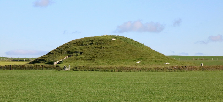
A new study has revealed that parts of Maeshowe, a 5,000-year-old tomb in Orkney, were built upside down to represent the afterlife.

She said: “I’m delighted that my research, studying the order by which stones have been placed during construction, has been able to reveal novel results and that it is, therefore, able to make a real contribution to the field of archaeology.

“Visualise the wall-stones are like wallpapers, and when you repeatedly hang them upside down in distinct locations patterns become discernible. The swaps include the reversal of multiple architectural features normally placed on the right-hand side being on the left only inside the side chambers.

“The interpretation is that the side chambers are built to be within the netherworld, by the main chamber walls acting as membranes, separating this life and the next, and that the internal walling material is conceived to physically represent the underworld.”

Maeshowe, which is visible for miles around, dates from 2,700 BC and is one of the fascinating ancient monuments that make up the Heart of Neolithic Orkney World Heritage Site.

The tomb is accessed by a long, narrow passageway which leads into a large central chamber, with three side chambers, where the dead were laid to rest. The chambered tomb is aligned perfectly with the setting sun during the time around the winter solstice when it shines deep into the passageway and illuminates the rear wall of the main chamber.

Visitors to Maeshowe will also see Viking-era graffiti in the central chamber, left by a group of Norsemen who broke into the tomb to take shelter one night during Christmas 1153.

The men were led by Earl Harald through the snow from Stromness to the parish of Firth.

The 30 inscriptions found in Maeshowe, make it one of the largest, and most famous, collections of runes known in Europe and can be viewed by torchlight.

The latest research will be published Cambridge University’s Archaeological Review, which is due out by the end of the year.

Nick Card, excavation director of the Ness of Brodgar, said, “Despite being a focus of attention since its first modern-day entry over 150 years ago, the iconic Maeshowe continues to reveal its secrets through careful and considered study.

This study offers new ways of approaching and understanding the construction and use of not only this monument but has wider implications for the study of Neolithic stone-built monuments and the society that constructed them.”

Wreckage of sunken WWII battleship found off Norway

Wreckage of sunken WWII battleship found off Norway

A sonar scan of the German warship Karlsruhe, which was recently discovered off the southern coast of Norway

CBS News reports that the 571-foot German warship Karlsruhe was found under 1,600 feet of water off the coast of Norway by the power company Statnett with multibeam echo sounders and a remotely operated vehicle.

The ship, equipped with nine cannons and three triple turrets, led the invasion of Norway on April 9, 1940, but was struck by a British submarine torpedo on its return trip.

The site of the wreck was unclear for the next 80 years. Nora Buli reports to Reuters, experts from the country’s state-run power grid operator, Statnett, identified a sunken vessel situated near one of the company’s underwater cables as the long-lost ship.

An element of sunken German WWII warship cruiser “Karlsruhe” that had been observed 13 nautical miles from Kristiansand
An element of sunken German WWII warship cruiser

Statnett engineers spotted the remains of 571-foot cruisers during a routine survey via sonar in 2017, according to Arnfinn Nygaard from the Norwegian broadcast networks NRK.

But the ship’s identity remained a mystery until late June, when photographs captured by a remotely operated vehicle (ROV) revealed its hull, gun turrets and telltale swastikas resting some 1,500 feet beneath the waves, per a statement.

Researchers identified Karlsruhe based on the shape of its hull and such details as the positions of its gun turrets, reports Reuters. The wreck is located just under 50 feet away from a power cable installed in 1977.

“You can find Karlsruhe’s fate in history books, but no one has known exactly where the ship sunk,” says Frode Kvalø, an archaeologist at the Norwegian Maritime Museum, in the statement.

“Moreover, it was the only large German warship that was lost during the attack on Norway with an unknown position. After all these years we finally know where the graveyard [of] this important warship is.”

The Karlsruhe cruiser prior to its sinking

Built-in the late 1920s, Karlsruhe was repurposed—and redecorated—by the Nazis during World War II.

It successfully supported Germany’s attack on Norway but fell victim to a British submarine when departing the port of Kristiansand. After crew members evacuated the hobbled ship, the Germans scuttled it themselves.

The newly rediscovered cruiser sank at the very start of the Nazis’ invasion of Norway, which saw the country’s government and king seek refuge in Britain, where they remained until the German surrender in 1945, according to Encyclopedia Britannica.

In the statement, Kvalø notes that large warships tend to turn around when sinking due to their high centre of gravity.

Karlsruhe, however, “stands firmly … below sea level with cannons pointing menacingly into the sea.”

The archaeologist adds, “With the main battery of nine cannons in three triple turrets, this was the largest and most fearsome ship in the attack group against Kristiansand.”

An element of sunken German WWII warship cruiser

Per NRK, the Norwegian Coastal Administration will now monitor the ship, as it may still contain upward of one million litres of fuel, as well as other potentially harmful chemicals.

Sunken WW2 battleship found off Norway; Video Source: Reuters.

4,000-year-old skeletons of mother Clutching a child to her chest at China

4,000-year-old skeletons of mother Clutching a child to her chest at China

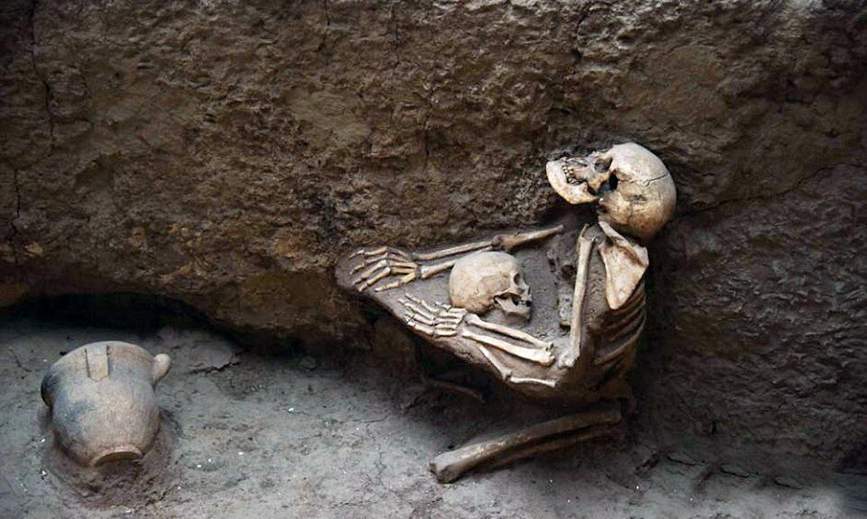
The loving embrace of a mother and her child lasts for 4,000 years, Chinese archaeologists reported after finding their interlocked skeletons.

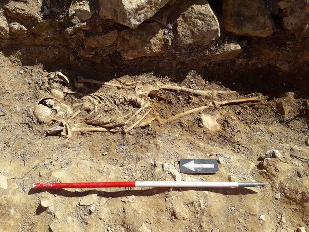
Skeletal remains show the mother kneeling down on the ground with her arms around her son in central China

Archaeologists unearthed proof of a mother’s love in Qinghai province, China, when they discovered the 4,000-year-old skeletons of a mother and child still locked in a dying  embrace.

The two skeletons are frozen in time, preserved in the stance they took in their final moments before an earthquake wiped out China’s “Pompeii of the East” around 2,000 BC.

The mother’s arms are draped around her son in what archaeologists believe to be both an embrace and an attempt to protect her son as catastrophe hit.

The mother was trying to shield her child from a massive earthquake that struck China in 2000 BC and triggered massive floods; the event is sometimes referred to as ‘China’s Pompeii’. The site is riddled with tragic scenes.

Lajia Ruins Museum, located in northwest China’s Qinghai province, is a 4000-year-old earthquake relic, with very well preserved artefacts and skeletons.

The entire disaster scene is so shocking it has been likened to the Pompeii tragedy. Pompeii was a Roman city wiped off the face of the Earth after a volcanic eruption and buried under ash and pumice.

Archaeologically, the entire site is stunning: it paints an incredibly well-preserved picture of an important ancient event.

It is also very important because it holds early clues to an early Bronze Age civilization that lived in the upper Yellow River region and of which we know very little about. But from a human point of view, it’s just heartbreaking.

These people had a rough fate, they were killed by a disaster they could do nothing to protect themselves against; they couldn’t even protect their children, try as they might. It’s a testimony to nature’s strength, and how weak we sometimes are against it.

I just hope they don’t separate the two skeletons. I’m not sure why – it’s not for a religious reason – but it just seems wrong to separate the two.

All In One Magazine