40,000-Year-Old Tree Shows What Happened During Earth’s Last Magnetic Pole Reversal

40,000-Year-Old Tree Shows What Happened During Earth’s Last Magnetic Pole Reversal

Trees are living memorial statues, and we can learn a lot from their rings. A tree can tell you if the winter was wet or if the area was affected by hurricanes or fires.

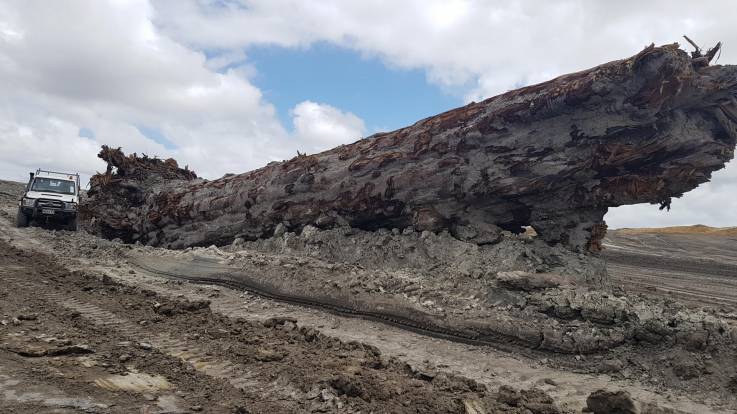
One particular tree attracted the attention of everyone. It was found in Ngawha, on New Zealand’s North Island. According to experts, the tree had a record of a reversal of Earth’s magnetic field. It’s actually an Agathisaustralis, also known as “kauri.”

The tree was found during excavation work for the expansion of a geothermal power plant.

Ngāwhā Generation is a subsidiary of Top Energy. They gave the kauri tree back to iwi. Of course, they agreed to take samples and study the segments.

The tree was buried 26 deep into the soil. It has eight feet in diameter and 65 feet in length. According to its carbon dating, the tree lived for 1,500 years. The giant thrived between 41,000 and 42,500 years ago.

Alan Hogg, from New Zealand’s University of Waikato, notes that they have never seen anything like this. According to him, the Ngāwhā kauri is unique. The tree lived when the magnetic field almost reversed. The magnetic north and south went off but didn’t complete a full reversal.

Experts note that Earth’s magnetic field is generated by the iron in the core. It produces electric currents that go far into space. The field acts as a barrier that protects Earth from the solar wind. It’s actually a stream of charged particles from the Sun that may remove the ozone layer in case it affects the atmosphere.

When reversed, the magnetic field weakens and caused higher radiation from the Sun going through. Extinction events in the past are often linked to these magnetic field reversals.

The rings of this tree have a full record of a near-reversal. It’s the first tree that lived during the entire event and was eventually found.

Hogg said, “It’s the time it takes for this movement to occur that is the critical thing…We will map these changes much more accurately using the tree rings.”

In the past 83 million years, 183 magnetic pole reversals took place.

The kauri tree revealed during the expansion of the Ngāwhā Generation geothermal power plant.  Chris Turney from the University of New South Wales led the analysis of the tree. He is an expert in paleoclimatology and climate change. His research is funded by the Australia Research Council.

He said, “The precious thing is this huge, lonely tree grew for some 1700 years across a remarkable period in our planet’s history when the Earth’s magnetic field flipped some 42,000 years ago, a period known as the Laschamp Excursion. Funded by the Australian Research Council we’re undertaking detailed measurements of the radioactive form of carbon through the tree rings.”

Each process is completed in 7,000 years. Monika Korte, the scientific director of the Niemegk Geomagnetic Observatory at GFZ Potsdam in Germany explains that it’s a slow process in which the field strength weakens, and the field becomes more complex. It shows more than two poles for a while, and then becomes stronger and aligned in the opposite direction.

NASA explains that magnetic field reversals happen at random intervals. The reversals developed a pattern in the last 20 million years. One reversal happens once every 200,000 to 300,000 years. The last one took place around 780,000 years ago.

Scientists didn’t expect the magnetic north pole to move, but it did recently. They updated the World Magnetic Model which represents our planet’s magnetic field. The WMM is used by the U.S. Department of Defense, the U.K. Ministry of Defense and many civilian systems.

“Because the Earth’s magnetic field has a major effect on how much radiocarbon is formed in the upper atmosphere, these precious analyses will allow us to investigate the magnitude and rate of change when the magnetic field reversed during the Laschamp; something not possible before and of great interest given recent changes in the Earth’s magnetic field,” Turner explained.

Walls of Jericho, Jericho, West Bank, Palestinian Territories, Middle East, Asia

The Oldest Defensive Wall on Earth Predates Egypt’s Oldest Pyramid by 5,300 Years

The Egyptian pyramids at Giza are remembered every time we speak of the pyramids. Although there are about 120 pyramids in Egypt, the most prominent temples in Giza are intimidating.

The Great Pyramid of Giza where it stood, accompanied by a nearly identical, albeit smaller pyramid, thought to have been built by Khufu’s successor Khafre. The smallest of the three pyramids at Giza is that of Menkaure, and it marked the end of pyramid-building at Giza.

While these are the most imposing and the most famous pyramids in Egypt, they are definitely not the oldest. It was believed that during the Third Dynasty reign of Pharaoh Djoser, the first Pyramid in Egypt was constructed around 4,700 years ago.

The Step Pyramid at Saqqara–the first colossal stone building in Egypt–was a monument that redefined architecture in Egypt. Not only is it the earliest callosal stone building in the history of Egypt, but it is also regarded as the earliest large-scale cut stone construction in the history of ancient Egypt.

With a total volume of 330,400 cubic meters (11,667,966 cu ft), rising to a height of more than 63 meters, the Step Pyramid was an unprecedented structure. The monument itself and the pyramid complex as a whole was of unseen scale. In fact, experts believe that such was the size of Djoser’s ancient wonder that it covered 15 ha (37 acres), which is around 2.5 times as large as the Old Kingdom town of Heirakonpolis.

The successful completion of the massive pyramid complex at Giza testifies that around 4,700 years ago, the people of ancient Egypt were capable of undertaking bewildering constructions.

A view of the Giza Pyramid Complex with the city of Giza in the background

As noted by Mark Lehner, the social implications of completing such a large and carefully sculpted stone structure are beyond staggering. In fact, the pyramid of Djoser testifies to the fact that already in 2,700 BC, ancient Egypt was a well-developed country, and the royal government had a new level of control of resources, both material and human.

Although the Step Pyramid of Djoser was a revolutionary undertaking in Egyptian architecture, and future pyramids that followed the footsteps of Djoser became some of the most impressive the world has ever seen, what happened before Djoser? What happened before the third dynasty of Egypt in other parts of the world?

Did the very first, megalithic stone-cut buildings appear in Egypt? Or, did other cultures develop similar, if not greater structures prior to Egypt’s Third Dynasty?

As it turns out, thousands of years before the Third Dynasty, when Egypt’s first pyramid was built, people were already creating mind-boggling stone-cut constructions.

The oldest temple on Earth is evidence of that.

Built between 13,000 and 11,000 years ago, the megalithic stones at Göbekli Tepe in present-day Turkey are evidence that dating back nearly to the last ice age, people on Earth had the ability to create ingenious and mind-boggling structures. Göbekli Tepe features some of the most impressive and oldest structures on Earth. Somehow, by means we have still not fully understood, ancient people at Göbekli Tepe managed to quarry, transport and erect massive blocks of stone weighing several tons.

The megalithic T-Shaped Pillars of Göbekli Tepe, an ancient site that predates the pyramids of Egypt by at least 8,500 years.

These standing stones would eventually make up what is now considered the oldest megalithic temple on the surface of the planet, bearing evidence that more than 10,000 years ago, people had the ability to build megalithic structures.

Göbekli Tepe is so ancient that it was abandoned in 8,000 BC. This means that the builders of the intricate temple built it and abandoned it before the pyramids of Egypt were even conceived. Not many people are fully aware of the complexity and scale of Göbekli Tepe and what it means in the history of mankind. So far, more than 200, massive pillars have been found in around 20 circles. Each of the pillars has a height of around six meters and has a weight of around ten tons. Although Göbekli Tepe is perhaps one of the most impressive architectural feats of mankind, there are numerous equally stumping structures spread across the planet.

Located in the city of Jericho in the West Bank, we find another bewildering structure, a wall that is arguably the oldest defensive wall discovered by archeologists anywhere in the world. It was built of undressed stones and is located at an archaeological mound referred to as Tell es-Sultan.

Archaeological surveys indicate the wall is a Pre-Pottery Neolithic defensive or flood protection wall and dates to around 8,000 BC. This means that some 10,000 years ago, ancient mankind built complex defensive structures using massive blocks of stone. The Neolithic wall was part of a greater defensive structure. Experts have revealed it was complemented by a stone tower built into it.

A map of the ancient city of Jericho.

Through surveys of the site, scholars believe that the wall was built in order to prevent floods and the tower was most likely used for ceremonial purposes. However, given the large dimensions of the wall (around 1.5 to 2 meters (4.9 to 6.6 ft) thick and 3.7 to 5.2 meters (12 to 17 ft) high, and the tower measuring around 8.5 meters (28 ft), researchers propose the wall and its adjacent structures served a defensive purpose as well.

Constructing something of that size around 10,00 years ago was not an easy task, and it is suggested that social organization, labor division, and classes were already clear at that time.

Surrounding the wall, the ancient builders created a ditch 8.2 meters (27 ft) wide by 2.7 meters (9 ft) deep. Surveys have shown that the ditch was actually cut through solid bedrock with a circumference around the town of as much as 600 meters (2,000 ft). This further adds to the complexity of the construction.

“The labor involved in excavating this ditch out of solid rock must have been tremendous. As we have discovered nothing in the way of heavy flint picks, one can only suppose that it was carried out with stone mauls, perhaps helped by splitting with fire and water,” explained archaeologists Kathleen Kenyon.

Historically the Wall of Jericho is of great importance. For example, the Book of Joshua deals with Jericho during the Late Bronze Age, at around 1400 BC, which is approximately 6,400 years after the Neolithic “Wall of Jericho” fell out of use.

The ancient city of Jericho is one of the oldest on Earth. So far, archaeological excavations have revealed more than 20 successive settlements at Jericho. The first settlement at the site is believed to have ebene created around 9,000 BC, which means it dates back at least 11,000 years, which is nearly at the very start of the Holocene epoch.

The evidence further supports the notion that settlements existed in the area as early as 10,000 BC, during the Younger Dryas period. By the time the Younger Dryas was coming to an end, the area was inhabited around the year.

Researchers Will Search for Spanish Treasure Ship

Researchers Will Search for Spanish Treasure Ship

Nearly 400 years after storms sent one of Spain’s greatest treasure galleons on to the sea outside Mexico, archaeologists from the two countries are to renew their search for the ship and its precious cargo of gold, silver, and jewels.

According to the storm hit, the omens for the Nuestra Señora del Juncal’s return voyage in October 1631 were decidedly ill. A day before the fleet of which it was a part set sail from Mexico, its commander died. The ships pressed on even though the Juncal was in a poor state of repair and taking on water.

It is hoped the project will be a training ground for young underwater archaeologists.

After weathering a fortnight’s storms, cutting the main mast and tossing cannons and other heavy objects overboard in a desperate attempt to lighten the ship, the crew could do no more. Of the 300 people on board, 39 survived by climbing into a small launch.

In May, underwater archaeologists from Spain and Mexico will begin a 10-day search for the Juncal. It is hoped that the work will be just the beginning of a two-decade-long scientific and cultural collaboration.

The joint project, which comes six years after Spain and Mexico signed a memorandum of understanding over their shared underwater cultural heritage, aims not only to locate and protect the Juncal but also to train a new generation of Latin American underwater archaeologists.

Dr. Iván Negueruela, the director of Spain’s National Museum of Underwater Archaeology, has been working closely with Roberto Junco, the deputy director of underwater archaeology at Mexico’s National Institute of Anthropology and History. Negueruela said the team had done its calculations and the chances of finding the ship were looking very promising.

“Because the cargo was so valuable – it was carrying lots of ingots – the authorities had a detailed inventory,” he said. “The survivors were also questioned in-depth and their statements help us to reconstruct what happened with quite a high degree of accuracy, so we have a fairly good idea of where the ship sank.”

The Juncal is thought to have been carrying between 120 and 150 tonnes of precious materials, dwarfing the 14 tonnes of cargo recovered from another Spanish wreck, the Nuestra Señora de las Mercedes, in 2007.

Negueruela said the Juncal was transporting riches beyond silver and gold from the New World, among them cacao, dyes and animal hides. Anything organic is unlikely to have survived four centuries of sitting in saltwater, however.

The priority from an archaeological point of view is securing the site and carrying out a methodical, exhaustive and transparent excavation. “When you have a cargo of such extraordinary riches, you’ve got to be totally transparent about what you’re doing, whether you bring up two tonnes of silver or a single silver spoon,” said Negueruela.

“We also want this to serve as a training ground for young underwater archaeologists from Latin America so that countries don’t find themselves at the mercy of pirates and treasure-hunting companies. There will be grants to allow two or three young archaeologists to come out with us each year to train.”

The idea is that within eight or 10 years there will be a group of young, well-trained archaeologists in each country where they’re needed.

“We older archaeologists are running out of time and we need to train up young archaeologists so that we can leave the seabed in good hands,” said Negueruela.

For him, the Juncal’s true riches are not its cargo but the vessel itself – and the chance, for once, to get to a wreck before the treasure hunters do.

“I’m really keen to discover exactly how the ship was constructed and to see how the bulkheads and the decks were put together,” he said.

“We’ve seen that with Mary Rose and the Vasa in Sweden. I want to know exactly how a galleon looked in the first half of the 17th century, and that’s fundamental: where were the sleeping quarters, the stores, the latrines, the eating areas. We know about them from drawings from the archives from the 16th to 18th centuries but we’ve never excavated them. This is such a rich source of information.”

This 3,700-Year-Old Babylonian Clay Tablet Just Changed The History of Maths

This 3,700-Year-Old Babylonian Clay Tablet Just Changed The History of Maths

The Babylonians developed trigonometry 1,500 years before the Greeks and were using a sophisticated method of mathematics which could change how we calculate today, which makes it a 3,700-year-old clay tablet.

The tablet, known as Plimpton 332, was discovered in the early 1900s in Southern Iraq by the American archaeologist and diplomat Edgar Banks, who was the inspiration for Indiana Jones.

This 3,700-Year-Old Babylonian Clay Tablet Just Changed The History of Maths
The tablet is broken and probably had more rows, experts believe

The true meaning of the tablet has eluded experts until now but new research by the University of New South Wales, Australia, has shown it is the world’s oldest and most accurate trigonometric table, which was probably used by ancient architects to construct temples, palaces, and canals.

However, unlike today’s trigonometry, Babylonian mathematics used a base 60, or sexagesimal system, rather than the 10 which is used today. Because 60 is far easier to divide by three, experts studying the tablet, found that the calculations are far more accurate.

“Our research reveals that Plimpton 322 describes the shapes of right-angle triangles using a novel kind of trigonometry based on ratios, not angles and circles,” said Dr. Daniel Mansfield of the School of Mathematics and Statistics in the UNSW Faculty of Science.

“It is a fascinating mathematical work that demonstrates undoubted genius.

Dr. Daniel Mansfield with the 3,700-year-old trigonometric table

The tablet not only contains the world’s oldest trigonometric table; it is also the only completely accurate trigonometric table, because of the very different Babylonian approach to arithmetic and geometry.

“This means it has great relevance for our modern world. Babylonian mathematics may have been out of fashion for more than 3000 years, but it has possible practical applications in surveying, computer graphics, and education.

“This is a rare example of the ancient world teaching us something new.”

The Greek astronomer Hipparchus, who lived around 120BC, has long been regarded as the father of trigonometry, with his ‘table of chords’ on a circle considered the oldest trigonometric table.

A trigonometric table allows a user to determine two unknown ratios of a right-angled triangle using just one known ratio. But the tablet is far older than Hipparchus, demonstrating that the Babylonians were already well advanced in complex mathematics far earlier.

Babylon, which was in modern-day Iraq, was once one of the most advanced cultures in the world

The tablet, which is thought to have come from the ancient Sumerian city of Larsa, has been dated to between 1822 and 1762 BC. It is now in the Rare Book and Manuscript Library at Columbia University in New York.

“Plimpton 322 predates Hipparchus by more than 1000 years,” says Dr. Wildberger.

“It opens up new possibilities not just for modern mathematics research, but also for mathematics education. With Plimpton 322 we see a simpler, more accurate trigonometry that has clear advantages over our own.

“A treasure-trove of Babylonian tablets exists, but only a fraction of them have been studied yet. The mathematical world is only waking up to the fact that this ancient but very sophisticated mathematical culture has much to teach us.”

The 15 rows on the tablet describe a sequence of 15 right-angle triangles, which are steadily decreasing in inclination.

The left-hand edge of the tablet is broken but the researchers believe that there were originally six columns and that the tablet was meant to be completed with 38 rows.

“Plimpton 322 was a powerful tool that could have been used for surveying fields or making architectural calculations to build palaces, temples or step pyramids,” added Dr. Mansfield.

The new study is published in Historia Mathematica, the official journal of the International Commission on the History of Mathematics.

Mysterious Egyptian Artifact From the Bronze Age Found Off Israeli Coast

Mysterious Egyptian Artifact From the Bronze Age Found Off Israeli Coast

When Rafi Bahalul found hieroglyphs in the seabed, he took a morning dive off the coast of Atlit, Israel.

Bahalul told Haaretz “I have seen that continued swimming for a couple of meters and then realized what I had seen and dived down to touch it, “It was like entering an Egyptian temple at the bottom of the Mediterranean.”

The Egyptian Stone anchor was discovered by Bahalul about 3,500 years old, confirmed by Jacob Sharvit, Head of Maritime Archeology Units of the Israel Antiquities Authority.

The Egyptian artifact/anchor shown with hieroglyphs found on the seabed. (Laura Lachman / Israel Museum )

The anchor is currently on loan from the Israel Antiquities Authority to the Israel Museum in Jerusalem and is on display as part of its Emoglyphs: Picture-Writing from Hieroglyphs to the Emoji exhibition.

Emoglyphs is the study of the transformation of picture writing from Egyptian hieroglyphs, developed some 5,000 years ago, to the ’emojis’ of the 21st Century.

Shirly Ben-Dor Evian, the curator of Emoglyphs, said the stone would have initially been part of a larger, ornate wall relief. Repurposed as an anchor, it was cut from the relief and drilled with a hole to attach a rope.

“The stone was discovered by chance — spotted on the seabed by a swimmer,” Ben-Dor Evian told ABC News and said the relic is still being researched. “The Egyptian relief was reused as a stone anchor on a ship sailing the Mediterranean coast,” she said.

Shirly Ben-Dor Evian points to the hands of Seshat, the Egyptian deity of writing, on the stone anchor discovered off Atlit.

Addressing the mystery of how the Egyptian relic was found off the coast of Israel, Ben-Dor Evian proposed that it was separated from an Egyptian ship sailing the Mediterranean coast, perhaps lost in a shipwreck.

“The ship crew must have lost the anchor or the ship was shipwrecked,” she said, adding that whether or not the anchor can contribute to a new understanding of ancient Egyptian life is “still under research.”

The Emoglyphs exhibit at the Israel Museum in Jerusalem is running until Oct. 12, 2020.

The site where Bahalul made the chance discovery, just south of Haifa, was already known to archaeologists, according to the Jerusalem Post.

Depicted on the stone are the hands of Seshat, the Goddess of Writing, Ben-Dor Evian said. An accompanying inscription reads, “mistress of the house of books.”

Emoglyphs will be showing until October 12th.

Ancient Pompeii’s Drains Back In Use After 2300 Years

Ancient Pompeii’s Drains Back In Use After 2300 Years

The old drainage system in Pompeii is so strong that it can still be re-activated following its completion almost 2,300 years ago.

An area of 1500ft stretch of tunnels underneath some of the famed Italian city’s most iconic structures was originally built to drain water downhill away from Pompeii’s center. 

Tunnel analysis showed that for centuries it had almost remained untouched and the complex system still exists in good shape.

Aerial map showing ancient Pompeii’s drains network with the sites (mentioned above) marked out.

‘The entrances to the drains were blocked but since we have problems today with flooding from the rain we will start using them again,’ Massimo Osanna, the director of the site, told The Times.

‘The fact we can do this is a testament to the excellent engineering skills at the time.’ 

A project has seen the Archaeological Park of Pompeii partner up with speleologists — professional cave analysts —  from the Cocceius Association.

Since 2018, the 1,500ft (457m) network of tunnels — which are big enough for a human to fit inside — has been carefully assessed. 

A further 1,500ft of tunnels will now undergo similar analysis to determine its state and if it is fit to be used again. Two manholes in the Civil Forum near the Centaur statue provide access to the drainage system.

Tunnel within ancient Pompeii’s drains system.
The system allowed excess rainwater to be drained out of the ancient city, towards the sea. The network is complex but structurally sound and the project revealed the tunnels were built in three phases

It then heads downhill underneath Via Marina and terminates near the Imperial Villa. The system allowed excess rainwater to be drained out of the ancient city, towards the sea. The network is complex but structurally sound and the project revealed that the tunnels were built in three distinct phases. 

Initially, the system was constructed in the late 3rd or early 2nd century BC, in the so-called Hellenistic phase, by the Samnites who inhabited the city before the Romans.

It was then expanded by the Romans using their famed engineering know-how in the 1st century BC before being put on pause for almost a century. 

The study dubbed the Republican phase.  

Evidence inside the tunnel showed its third and final portion was built in the years preceding the devastating 79AD eruption of Vesuvius that destroyed the city.

‘The project of exploring these tunnels forms part of the activities of the Archaeological Park of Pompeii that aim to broaden our understanding of the site, which is the essential basis of any monitoring or safeguarding intervention’, Massimo Osanna, Director General of Archaeological Park of Pompeii, said in a statement.  

‘This initial, but the complete, exploration of the complex system of underground canals confirms the cognitive potential which the Pompeian subsoil preserves, and demonstrates how much still remains to be investigated and studied. 

‘Furthermore, many gaps in knowledge from the past regarding certain aspects or areas of the ancient city are being filled, thanks to the collaboration of experts in various sectors, which allow us to gather ever more accurate data as a result of specialized skills which had never been employed in other periods of excavation or study.’

The archaeologists excavating a tunnel within Pompeii’s drains.

Iron Age Gold Coin Hoard Declared Treasure

Iron Age Gold Coin Hoard Declared Treasure

A collection of Iron Age gold coins has been declared treasure by Suffolk’s senior coroner, having been discovered almost a year ago.

The gold Stater coins found near Blythburgh, east Suffolk last February. Image courtesy of Suffolk County Council.

19 coins were found near Blythburgh, east Suffolk last February by a metal detectorist.

The anonymous finder reported the discovery to Suffolk County Council, and through them, the coins have been the subject of extensive cleaning and analysis for the past year, ready for sale to museums keen to display the collection to the public.

The gold hoard has been described as “really unusual” given the area it was found, with experts usually finding these types of coins just north of the River Thames – some 90 miles away from Blythburgh. The hoard even includes one previously-undiscovered style of coin.

The Iron Age was a rough period of time at its longest, ranging from 1200BC to 15BC, though this timeframe varies per country in Europe.

The prevalence of iron spread across the world from Asia and the Middle-East to Europe around this time and led to the development of improved tools, weapons, and armour.

Speaking to the BBC about the find, archaeologist Dr. Anna Booth described the significant find as an example of “cross-cultural interaction” between nearby counties.

Tribes took the place of counties in the Iron Age period, and the ‘minting’ (hammering) of the coins is thought to have occurred between 45-25BC, though Dr. Booth estimates that the coins were later buried – perhaps around 20AD.

The gold Stater coins and two of the smaller quarter Staters. Image courtesy of Suffolk County Council.

Many of the coins – determined as gold Staters and quarter Staters – depict Addedomaros, King of Trinovantes.

Bearing that in mind, it would be logical to assume that the trading was between the Trinovantes, who occupied Suffolk and Essex, and the Catuvellauni – located in the place of modern-day Hertfordshire and London. This would connect it to the Thames region.

However, territories varied and it could well have been that the Trinovantes occupied territory north of the River Thames, but may well have lost Blythburgh, which lies near the border with the Iceni tribe of Celts who occupy what would be Norfolk and parts of the Lincolnshire and Cambridgeshire Fens.

Museums across the UK have begun declaring their interest in taking the coins from Suffolk County Council, with Dr. Booth speaking of “a lot of interest” in the Blythburgh hoard.

Expert Invasion – How the Romans conquered Britain – Roman Rule

The Helmet That Shows Celtic Warriors Helped the Roman Army Conquer Briton

An important find was discovered at an old Iron Age shrine in England. It included coins and other items from both the Iron Age and the Roman era.

A 2,000-year-old unique Roman cavalry helmet was found among the finds. Having been re-examined some 10 years after is first discovered, some believe that the helmet throws an interesting new light on the nature of early relations between Britons and Rome and the development of Roman auxiliary forces.

The helmet was found as part of a treasure that was uncovered by a retired teacher, Ken Wallace, with a hand-held metal detector that he bought for approximately $300 (£260). 

It was found in Hallaton, Leicestershire, in the East Midlands. Mr. Wallace knew he had found something big and he immediately reported his find to the relevant local authorities. Later he was paid $200,000 (£150,000) and the owner of the land where the find was made received a similar amount.

Experts began an extensive dig of the site in 2010 and according to the Daily Telegraph they uncovered “5,000 coins and the remains of a feast of suckling pigs.” There was also found some ingots and fragments of metal that came from a Roman cavalryman’s helmet. The find of the headgear was hailed as very important and it came to be known as the ‘Hallaton helmet’ after the area where it was unearthed.

Hallaton hoard parade helmet

According to the Daily Telegraph, the cavalry helmet was “restored from 1,000 fragments by experts at the British Museum.” It was made of sheet iron and was once ornately decorated with gold leaf designs and had cheek pieces and was most likely worn by a cavalryman. 

The reconstruction of the Roman helmet allowed specialists to study it and they were able to find designs with images of battles, victories and a female figure escorted by lions, probably a goddess. There is also the figure of a Roman Emperor on a horse who is apparently, accompanied by Victoria, the goddess of Victory, on one of the cheekpieces.

Parts of the decorated cheek pieces of the helmet. Remains of 7 cheekpieces in all were found, meaning there were pieces of several helmets left at the shrine.

The helmet pieces were dated to the Roman invasion of Britain (43 BC), which was ordered by Emperor Claudius (10 BC-54 AD) of the Claudian-Flavian Dynasty.

It was something of a mystery as to why the helmet was offered at the shrine and also its origin, as at the time it would have been controlled by local Celtic tribes. There were several theories proposed for the presence of what would have been a highly prized object at the shrine including it was a diplomatic gift or booty from a raid.

Roman Cavalry Reenactment – Roman Festival at Augusta Raurica.

However, the theory was put forward and it was one that had dramatic implications for our understanding of the Roman conquest of Britain. It has been proposed that the helmet did not belong to a Roman but to a Briton and that he deposited it at the shrine. The BBC reported that “its date, close to the Roman invasion of 43 AD, meant it could be evidence of Celtic tribes serving with the Roman army.” 

This theory is very plausible because there are an extensive documentary and archaeological evidence that non-Romans served in the Emperor’s armies as auxiliaries.

These were recruited from tribes inside and outside the Empire and they provided extra manpower to the legions – for example, many Germans fought with Julius Caesar during the conquest of Gaul. 

The reconstructed helmet possibly indicates that Celtic Britons served as auxiliaries during the reign of Claudius.  It is well-known that they served as auxiliaries, but it was not thought that they fought with the Romans at such an early date. Moreover, such an elaborate helmet may show that Britons may even have risen to a high rank in the Roman army.

The discovery led some to conclude that some Celtic tribesmen actually served with the invaders during the conquest of modern-day England.

The helmet provides strong evidence that was even Celts from Briton who served in the Roman army before the conquest, having dramatic implications for our understanding of Ancient Britain and the evolution of the Roman army.

All In One Magazine