1,300-Year-Old Corn God Statue Shows How the Maya Worshipped Maize
The depiction of a young Maya maize god is consistent with other portrayals of beheaded Maya deities.
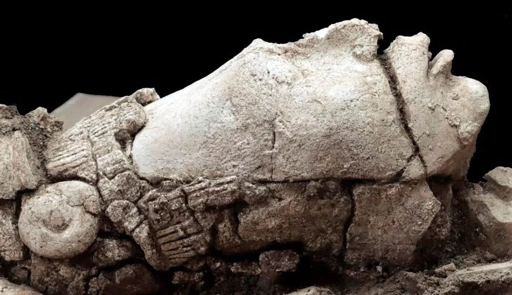
While excavating a section of the ancient Maya city of Palenque last summer, archaeologists in Mexico were surprised to see the tip of a large nose emerging from underneath the dirt.
As they carefully brushed away more debris at El Palacio, nostrils, a chin and the parted lips of a half-open mouth appeared.
Now, Mexico’s National Institute of Anthropology and History (INAH) has revealed that the ancient face was part of a 1,300-year-old stucco head depicting a young Hun Hunahpu, the Maya’s maize god.
The find is the first of its kind at the Palenque archaeological site, which is located in the southern Mexican state of Chiapas.
“The discovery of the deposit allows us to understand how the ancient Maya of Palenque constantly revived the mythical passage on the birth, death and resurrection of the maize god,” Arnoldo González Cruz, an archaeologist who was part of the find, says in a statement.
The face emerged from an archaeological dig in Mexico. National Institute of Anthropology and History (INAH)
The nine-inch-tall head had an east-west orientation that archaeologists believe represents the emergence of the maize plant at dawn, per INAH. They say Palenque’s Maya residents likely placed the large stone sculpture over a pond to symbolize the entrance to the underworld.
The sculpture was intended to depict a beheaded figure, echoing other Maya art depicting various headless gods.
Maize, or corn, was not only an important source of food for the Maya—it also played a fundamental role in their beliefs. According to the Popol Vuh, the Maya’s K’iche’-language creation story, gods created humans out of yellow and white corn.
As such, the Maya worshipped Hun Hunahpu, whom they believed was decapitated every fall around harvest time, then reborn the following spring at the start of the new growing season, as Ariella Marsden reports for the Jerusalem Post. Because of this pattern, the Maya also associated Hun Hunahpu with the cycle of human life and the changing seasons.
First domesticated about 9,000 years ago in what is now Mexico, maize played an important role in both Mesoamerican culture and the history of archaeology. As author Charles C. Mann writes in Maize for the Gods: Unearthing the 9,000-Year History of Corn, cobs of ancient maize discovered in New Mexico “were among the first archaeological finds ever carbon-dated.”
The head of a young Maya maize god was made of stucco and buried in a pond archaeologists think was once used for stargazing.
Archaeologists dated the stucco statue to the Late Classic Period of roughly 700 to 850 B.C.E. They believe it represents a youthful maize god because of the figure’s “tonsured,” partially-shaven haircut, which looks like ripe maize. This depiction of the deity was common at the time, per the Dallas Museum of Art, and symbolized “mature and fertile” corn.
When they first built the maize god’s pond, the Maya likely peered into it to study the reflection of the night sky. Later, researchers say, they symbolically shuttered the pond by breaking down some of the stucco and filling it in with shells, carved bone fragments, pieces of ceramics, obsidian arrowheads, beads, vegetables and the remains of animals, including quail, river turtles, whitefish and dog.
They topped the pond with a limestone slab, then surrounded it with three short walls and filled everything in with loose stones and soil.
Because it was preserved in a humid environment for such a long time, the divine head must now undergo a drying process, undertaken by INAH’s National Coordination for the Cultural Heritage Conservation, to preserve it. After more than a thousand years underground, the stone sculpture is being reborn—just like the beloved deity it depicts.
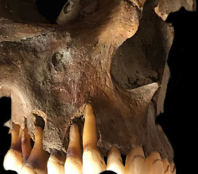
Researchers found ancient herpes DNA in the teeth of a man from the eighteenth century who was a fervent pipe smoker.
Ancient DNA extracted from the teeth of humans who lived long ago is yielding new information about pathogens past and present.
In one of the latest studies, researchers uncovered and sequenced ancient herpes genomes for the first time, from the teeth of long-dead Europeans. The strain of herpes virus that causes lip sores in people today — called HSV-1 — was once thought to have emerged in Africa more than 50,000 years ago. But data published in Science Advances on 27 July indicate that its origin was much more recent: around 5,000 years ago, during the Bronze Age.
The findings hint that changing cultural practices during the Bronze Age — including the emergence of romantic kissing — could have factored into HSV-1’s meteoric rise.
This and other studies related to tooth-extracted DNA are leading to surprising insights into our shared history with the disease, says Christiana Scheib, an archaeomolecular biologist at the University of Tartu in Estonia. “All of the pathogens we have today were once novel infections,” she says. “It’s important to study ancient DNA so we can understand these past experiences and keep future generations safe from epidemics.”
Breakthroughs in bones
Teeth are treasure chests for ancient DNA because of their ability to protect biological molecules from degradation. In the past decade, scientists have used increasingly powerful sequencing technologies to reconstruct the genomes of long-dead humans and animals — the oldest being a mammoth that died 1.6 million years ago — using DNA found in their teeth.
In the process, they have also sorted through the genetic material of bacteria and viruses preserved in teeth. Molars, incisors and so on have blood vessels in their roots, so when a person or animal dies, these bones become repositories for whatever pathogens were moving through their bloodstream at the time of death.
The realization that teeth are caches for pathogen DNA has opened the study of ancient diseases to “a completely different kind of knowledge than what we could have accessed before”, says Martin Sikora, an ancient-genomics researcher at the University of Copenhagen in Denmark.
This genetic information has provided researchers with molecular evidence to pinpoint when and where pathogens were at a given time, Sikora says. In 2013, scientists used DNA extracted from teeth to confirm that the Justinian plague, which swept across the Mediterranean and northern Europe in the sixth century, was the first major outbreak of the plague bacterium Yersinia pestis. And in June, a different group of researchers reported that the strain of Y. pestis that launched the Black Death — which killed upwards of 60% of people in some parts of Eurasia in the fourteenth century — probably evolved in what is now Kyrgyzstan, on the basis of DNA from teeth found in that region.
Sifting through remains
Studying ancient DNA can also help researchers to learn about the history of less deadly pathogens, such as the strain of oral herpes that has infected about two-thirds of the global population under age 50 today. In 2016, Scheib and her colleagues were looking for traces of Y. pestis in the 600-year-old tooth of a teenager who died in St John’s Hospital in Cambridgeshire, UK, when they stumbled across genetic sequences that seemed to match those of HSV-1.
Until that point, “there was no published ancient herpes DNA at all”, she says. The oldest herpes genome on record had been isolated from someone living in New York in 1925. The discovery led Scheib and her colleagues to look for signs of herpes in other remains. For this, the team needed to find people who had died of active infections. HSV-1 spends most of its time hiding in the nervous system of its host. But during times of stress, the virus moves into the bloodstream and flares up into ‘cold’ sores.
After sorting through dozens of remains, the researchers eventually found and extracted herpes DNA from the teeth of three people who died from active infections, including a young woman buried outside what is now Cambridge, UK, in the sixth century.
By evaluating the genetic mutations that evolved among the four ancient genomes and comparing them with modern HSV-1 strains, the researchers deduced that they all had a common ancestor that popped up around 5,000 years ago. Before this, different versions of herpes were circulating, Scheib says. But HSV-1 evolved to ruthlessly outcompete them.
Kiss and tell
Exactly what led this new variety of herpes to be more successful than older versions is still unclear. But Scheib says the team’s analysis suggests that HSV-1 emerged during a period of intense migration during the Bronze Age when it could have hitched a ride with people as they moved into Europe from the steppe grasslands of Eurasia.
And it might also have spread with the growing practice of romantic kissing, which was invented around 3,500 years ago on the Indian subcontinent and was probably later taken up in Europe, during Alexander the Great’s military campaigns in the fourth century. Herpes is usually spread from parent to child through close contact. Romantic kissing might have provided HSV-1 with a faster route to infect people and could have helped the virus outcompete earlier versions of herpes, the researchers say.
Fully unravelling the history of herpes and other pathogens will require older and more geographically diverse samples, but this study is a good example of the kind of information that can be accessed with ancient DNA, says Daniel Blanco-Melo, an evolutionary virologist at the University of Washington in Seattle.
Theoretically, researchers could sequence DNA from pathogens that infected even older humans and animals, potentially living one million years ago, Sikora says. This might allow scientists to learn about the organisms that infected ancient human species, such as Neanderthals and Denisovans. But technological limitations mean that researchers are currently able to sequence only the genetic material of pathogens that contain double-stranded DNA, excluding many important RNA viruses, such as the ones that cause polio and measles.
Still, ancient DNA is providing a window into our shared history with the disease, Sikora says. “We’re at the beginning of the maturation of this field,” he adds. “I expect we’re going to get very exciting new insights in the next couple of years.”
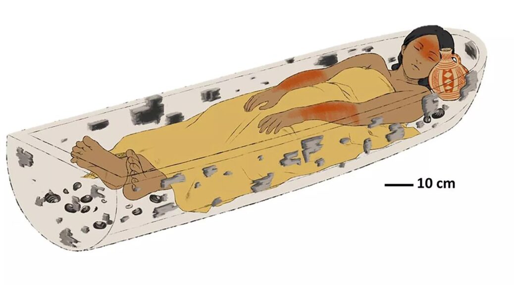
Remains of a woman from 800 years ago were found in a Wooden canoe
An illustration of a deceased young woman lying in a wampos (ceremonial canoe) with a pottery jug near her head.
Up to 1,000 years ago, mourners buried a young woman in a ceremonial canoe to represent her final journey into the land of the dead in what is now Patagonia, a new study finds. The discovery reaffirms ethnographic and historical accounts that canoe burials were practised throughout pre-Hispanic South America and refutes the idea that they may have been used only after the Spanish colonization, according to the authors of the study.
“We hope this investigation and its results will resolve this controversy,” said archaeologist Alberto Pérez, an associate professor of anthropology at the Temuco Catholic University in Chile and the lead author of the study, published Wednesday (Aug. 24) in the journal PLOS One.
Canoe burials are well attested and are still practised in some areas of South America, Pérez told Live Science. But because wood rots rapidly, the new finding is the first known evidence of the practice from the pre-Hispanic period. “The previous evidence was important and was based on ethnographic data, but the evidence was indirect,” he said.
The archaeological site in northwest Argentina was excavated between 2012 and 2015 before a well was built at the location, which is on private land.
The burial described in the study, at the Newen Antug archaeological site near Lake Lacár in western Argentina, indicates that mourners buried the woman on her back in a wooden structure crafted from a single tree trunk that had been hollowed out by the fire.
The same burning technique has been used for thousands of years to make “dugout” canoes known as “wampos” in the local Mapuche culture, and evidence suggests that Indigenous people prepared the woman’s remains so that she could embark on a final canoe journey across mystical waters to her final abode in the “destination of souls,” Pérez said.
Pre-Hispanic burial
The woman’s grave is the earliest of three known pre-Hispanic burials at the Newen Antug site, which archaeologists excavated between 2012 and 2015, before a well was built at the location, which is on private land. The location is at the northern extreme of the region known as Patagonia, which consists of the temperate steppes, alpine regions, coasts and deserts of the southern part of South America.
Radiocarbon dating indicates the woman was buried more than 850 years ago and possibly up to 1,000 years ago, while her sex and age at death — between 17 and 25 years old — were estimated from her pelvic bones and the wear on her teeth, according to the study. (Evidence suggests the Mapuche have lived in the region since at least 600 B.C.)
A pottery jug decorated with white glaze and red geometric patterns, placed in the grave by her head, suggests a connection with the “red on white bichrome” tradition of pre-Hispanic ceramics on both sides of the Andes mountains, the researchers found. This is the earliest known example of this type of pottery being used as a grave gift, according to the study.
Canoes known as wampos in the Mapuche language were constructed by hollowing out a single tree trunk with fire, with thicker walls at the bow and stern.
Given its age and the humid climate, the burial canoe has rotted away, and only fragments of wood remain. But tests suggest that the fragments came from the same tree — a Chilean cedar (Austrocedrus chilensis) — and that it had been hollowed out with fire.
Shells found in the grave show that her body was placed directly on a bed of Diplodon chilensis, a type of freshwater clam that was likely brought from the shores of Lake Lacár more than 1,000 feet (300 meters) away, the researchers wrote.
The young woman was buried more than 800 years ago in a wampo, or ceremonial canoe, that researchers think symbolized a boat journey to the land of the dead.
In addition, the position of the body — with the arms gathered above the torso, and the head and feet raised — indicates that the woman was buried inside a concave structure with thicker walls at the ends, which correspond to the bow and stern of a canoe, Pérez said.
Taken together, these aspects suggest the woman was interred in a traditional canoe burial representing the Mapuche belief that a soul must make a final boat journey before it arrives in the land of the dead. “The material evidence all goes in the same direction, and there is a whole battery of ethnographic and historical information that accounts for it,” Pérez told Live Science in an email.
Destination of souls
According to Mapuche belief, the destination of the deads’ souls was “Nomelafken” — a word in the Mapuche language that translates to the “other side of the sea” — and the newly dead would make a metaphorical boat journey for up to four years before they arrived at a mythical island called Külchemapu or Külchemaiwe, Pérez and his colleagues wrote in the study.
A historical report from the 1840s by the Chilean politician Salvador Sanfuentes remarked that local people “site the graves of their dead on the bank of a stream to allow the current to carry the soul to the land of souls” and that ceremonial canoes were buried as coffins to carry the dead on this journey, the researchers wrote.
The metaphor of the recently deceased making such a canoe journey to a final destination seems to have been prevalent throughout South America in pre-Hispanic times, and possibly for thousands of years, Pérez noted.
“We infer that this was a widespread practice on the continent, although it is little known to archaeology due to conservation problems,” such as the degradation of wood in humid climates, he said. “The antiquity of these practices is uncertain, but we know such navigation technologies were used there more than 3,500 years ago, so we can estimate that date as a potential time limit.”
The new study has great scientific importance for archaeological and anthropological research in the Patagonia region, said Nicolás Lira, an assistant professor of archaeology, ethnography and prehistory at the University of Chile who wasn’t involved in the research.
“The findings … are of exceptional preservation for the humid environment of the region, where rivers and lakes shape the landscape in an interconnected [river] system that facilitated and encouraged navigation,” Lira told Live Science in an email.
Juan Skewes, an anthropologist at Alberto Hurtado University in Chile who wasn’t involved in the study, said the Newen Antug burial was “strong evidence” of a shared cultural tradition between the east and west “slopes” of the Andes.
Meanwhile, historical and ethnographic records suggest such canoe burials represented a symbolic relationship between the Mapuche people and bodies of water, but that relationship wasn’t their only consideration, Skewes said. For example, “trees are part of almost every aspect of the Mapuche’s daily life, Skewes said. “Aside from having associations with mortuary practices, they are linked to childbirth and to the memories of the dead.” That might mean that the construction of a burial wampo from a single tree could have had extra meaning, in addition to the canoe’s symbolic function during the final voyage of the dead, he said.
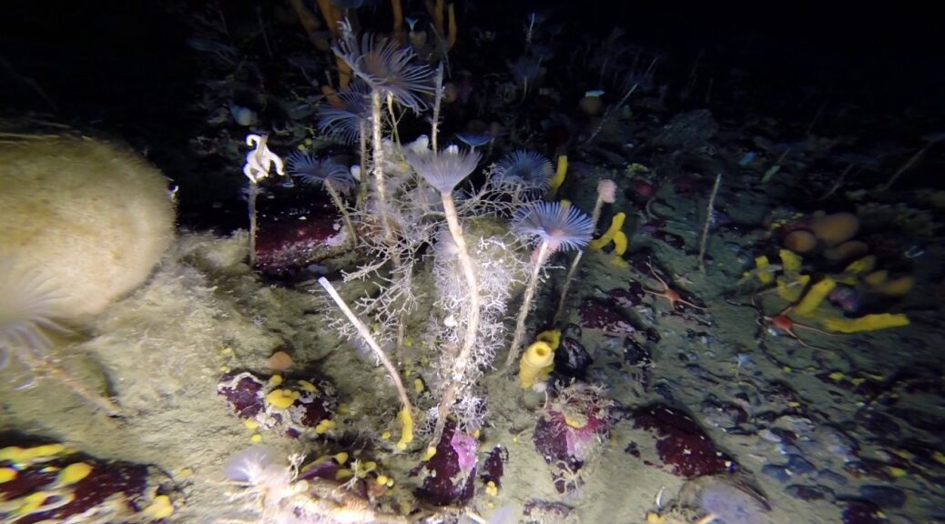
The Discovery of a ‘hidden world’ under Antarctic ice has scientists jumping for joy
Researchers discovered swarms of shrimplike amphipods while they were exploring an underground Antarctic river.
A never-before-seen ecosystem lurks in an underground river deep below the icy surface of Antarctica. Researchers recently brought this “hidden world” into the light, revealing a dark and jagged cavern filled with swarms of tiny, shrimplike creatures.
The scientists found the secret subterranean habitat tucked away beneath the Larsen Ice Shelf — a massive, floating sheet of ice attached to the eastern coast of the Antarctic peninsula that famously birthed the world’s largest iceberg in 2021.
Satellite photos showed an unusual groove in the ice shelf close to where it met with the land, and researchers identified the peculiar feature as a subsurface river, which they described in a statement.
The team drilled down around 1,640 feet (500 meters) below the ice’s surface using a powerful hot-water hose to reach the underground chamber.
When the researchers sent a camera down through the icy tunnel and into the cavern, hundreds of tiny, blurry flecks in the water obscured the video feed. Initially, the team thought their equipment was faulty.
But after refocusing the camera, they realized that the lens was being swarmed by tiny crustaceans known as amphipods. This caught the team off guard, as they had not expected to find any type of life this far below the icy surface.
“Having all those animals swimming around our camera means there’s clearly an important ecosystem process happening there,” Craig Stevens, a physical oceanographer at the National Institute of Water and Atmospheric Research (NIWA) in Auckland, New Zealand, said in a statement.
The discovery of the secret shrimp-infested structure had the team “jumping up and down for joy,” Stevens added.
Experts have long suspected that there is a vast network of rivers, lakes and estuaries underneath Antarctica, but until now these features have been poorly studied. It was previously unknown if they harboured life, which makes the new finding even more important.
“Getting to observe and sample this river was like being the first to enter a hidden world,” lead researcher Huw Horgan, a glaciologist at Te Herenga Waka – Victoria University of Wellington in New Zealand, told The Guardian.
Horgan first spotted hints of the subsurface structure in 2020 while looking at a satellite photo of the area. It was visible as a long depression, or groove, stretching across the ice — a hallmark of an underground river.
However, despite being prominent in the satellite images, the groove initially eluded surface detection, Stevens said. “But then we found this tiny, gentle slope and guessed we’d got the right spot.”
Researchers drilled more than 1,600 feet under the Larsen Ice Shelf.
After sending the camera down into the river, the team was surprised to learn that the cavern looked drastically different from what they had predicted.
The researchers had expected that the roof of the chamber would be smooth and flat. But instead, they found that the roof was very uneven and had lots of steep undulations.
The cavern was also much wider nearer the roof. “It looked like a loaf of bread, with a bulge at the top and narrow slope at the bottom,” Stevens said.
The researchers also unexpectedly discovered that the water column underground split into four or five distinct layers of water flowing in opposite directions. “This changes our current understanding and models of these environments,” Stevens said. “We’re going to have our work cut out understanding what this means.”
The underside of the river’s icy roof looked nothing like what the researchers were expecting.
The team arrived above the buried river just in time to make another interesting observation. The researchers set up camp a couple of days before the record-shattering eruption of the Hunga Tonga-Hunga Ha’apai volcano in Tonga on Jan. 15.
The massive explosion caused pressure waves that rang Earth’s atmosphere like a bell, and sensors the researchers had placed on the ice’s surface recorded similar pressure waves moving through the underground chamber. “Seeing the effect of the Tongan volcano, which erupted thousands of kilometres away, was quite remarkable,” Stevens said. “It is a reminder about just how connected our whole planet is.”
The scientists will continue to study the newfound subsurface ecosystem and hope to learn more about how the nutrients in the water are cycled through Antarctica’s underground water networks to support the abundance of life that lives there.
However, the researchers also worry that even hidden ecosystems like this one may be at risk from rapidly warming temperatures caused by climate change. “The climate is changing, and some key focal points are yet to be understood by science,” Steven said. “But what is clear is that great changes are afoot.”
New Thoughts on Societal Changes in Bronze Age Crete
A modern scientific analysis of ancient stone tools is challenging long-held beliefs about what caused radical change on the island of Crete, where the first European state flourished during the Bronze Age: the ‘Minoan civilization.’
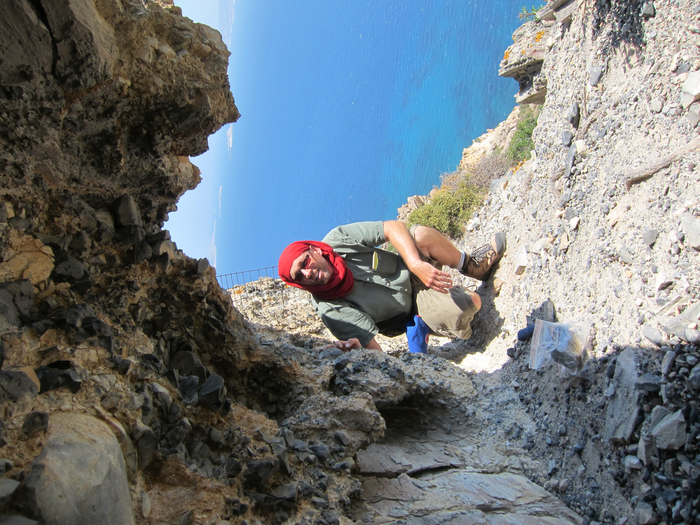
Lead researcher Tristan Carter in front of a quarry obsidian exposure on Melos
About 3,500 years ago, Crete underwent significant cultural transformations, including the adoption of a new language and economic system, burial customs, dress and drinking habits – all of which could be traced to the neighbouring Mycenaean Greek mainland.
At roughly the same time, many important sites across the island were destroyed and warriors’ graves appeared at the famed palace of Knossos, leading scholars to long believe that these seismic changes had been the result of a Mycenaean invasion.
A new study, published online in the journal PLOS One questions that theory.
“Our findings suggest a more complex picture than previously believed,” explains Tristan Carter, a lead author of the study and professor in the Department of Anthropology at McMaster University who has conducted research in north-central Crete for nearly three decades.
“Rather than wholescale cultural change, our study has found evidence of significant continuity after the alleged invasion. While new practices can be initiated through external forces such as invasion, migration, colonialism, or cross-cultural intermarriage, we also know of examples where locals choose to adopt foreign habits to distinguish themselves within their own society,” says Carter.
Rather than looking at things like burial, art, or dress, practices that tend to shift with fashion, archaeologists have begun to look more closely at more mundane, everyday practices as a better insight into a culture’s true character, he explains.
For the study, the researchers analyzed a sample of tools the Bronze Age Cretans fashioned from obsidian, a black volcanic glass which is sharper than surgical steel when freshly flaked.
Vassilis Kilikoglou, director of the Demokritos national research centre in Athens, used a nuclear reactor to determine the origin of the raw materials and found them to be from the Cycladic island of Melos.
When these results were considered together with the way the obsidian blades had been made and used for work such as harvesting crops, it was clear the community had lived the same way their predecessors had for the past thousand years, which continued to be distinct from life on the Greek mainland.
“Our analysis suggests the population had largely remained local, of Minoan descent,” says Carter and Kilikoglou.
“This is not to say an invasion of Crete didn’t occur, but that the political situation across the rest of the island at this time was more complex than previously believed with significant demographic continuity in many areas.”
The researchers believe that while local elites were strategically aligned with Mycenaean powers, as evidenced by their conspicuous adoption of mainland styles of dress, drinking, and burial, most people continued to live their lives in much the same way as before.
Cupra Marittima, in Italy’s Marche region, is today a sleepy seaside town — but it was once a thriving and powerful outpost of the Roman Empire. Close to the pristine beaches of the Adriatic coast lie the ruins of the ancient Cupra temple, where a new discovery has come to light.
Last week, archaeologists recovered parts of the 2,000-year-old temple’s frescoed walls and ceiling, painted in blue, yellow, red, black and green hues and decorated with flowery garlands, images of candelabra and tiny palms.
Finding ancient Roman temples with interiors “still covered in paintings” is “extremely rare,” said archaeologist Marco Giglio, the site’s research project coordinator and a professor at the University of Naples L’Orientale.
“It’s the first time that the ruins of a shrine painted with such a wide palette of colours in an incredibly well-preserved state — and with such rich, elaborate decorations — has been unearthed,” he claimed in a phone interview, adding: “Once we have cleaned and analyzed all the 100 fragments found and pieced them together, we hope it will give us a complete picture of what the temple once looked like.”
Colourful wall fragments recovered from the site.
A red fragment is carefully recovered.
Giglio hopes that the discovery sheds new light on the engineering techniques used by the Romans. Studying the walls’ recurring decorative motifs may also help researchers further understand the city’s local economy.
“The chronology of the different styles and decorative elements could tell (us) a lot about the artisan shops active at the time,” he said. “And the patterns and motifs could highlight whether it was the work of just one atelier or more.”
Images of candelabra decorated the walls of the temple.
Unusual painting style
The Cupra temple, built at the start of the first century AD, was the spiritual hub of a strategically and commercially important city that helped the Romans control the Adriatic coast and its maritime trading routes. Excavation began in July and is being led by the University of Naples L’Orientale and Cupra Marittima’s town council, which oversees the archaeological park where the old city’s ruins are situated.
A fragment was found with sky-blue paint.
Unusually, the newly discovered wall paintings appear to have been created in the so-called Third Pompeian (or “ornamental”) style typically used to decorate rich households in Pompeii and Rome, rather than religious structures, according to Giglio.
The ancient sanctuary is thought to have had a sky-blue ceiling, while the lower part of the temple’s walls was painted yellow. Red, black and yellow squares were separated by images of candelabra and garlands, with green bands of colour running horizontally along the walls. “Recovering intact ancient wall paintings like these are very rare. Paint is hard to preserve across time due to humidity, and it’s also very hard to dig out correctly during an excavation,” said Ilaria Benetti, an archaeologist from Pisa and Livorno provinces’ Superintendence of Archaeology, Fine Arts and Landscape in a phone interview.
“The incredible state of preservation and integrity of the frescoed parts, and the extremely rich colour palette used — particularly the bright sky-blue and pinkish-red — stand out as quite exceptional when compared to the traditional red paint normally used in ancient times, thus suggesting it was a lavish shrine,” added Benetti, who is a frescoes expert but was not directly involved in the excavation.
A flowery motif breaks up a block of red.
Giglio added: “The sky-blue colour is very rare for ceilings, which leads us to believe it was meant to indicate the celestial vault and that the shrine was built to honour a goddess.”
Although the temple shares a name with Cupra, an Etruscan goddess later incorporated into Roman religion, archaeologists have yet to determine which cult was associated with the shrine. A large statue of a goddess was likely kept in the main cell for worshippers, said Giglio. Over time, most of the temple was destroyed, though the podium and a staircase leading to the entrance have survived. The rest of the shrine has been reduced to a heap of fragments lying one meter (more than three feet) below the ground, where archaeologists began digging earlier in the summer.
Research into the temple began in 2015, following a partnership between the Cupra archaeological park and the University of Naples L’Orientale. The temple will eventually be incorporated into the wider site, which gives visitors access to the Roman city’s ruins.
The temple underwent several radical changes after its foundation, making it harder for Gilgio’s team to envision what it originally looked like. In 127 AD, the Roman emperor Hadrian funded a complete overhaul of the shrine as he feared it might collapse due to structural damage caused by ageing or natural disasters.
To reinforce the structure, Hadrian is thought to have had the painted walls chiselled off and covered in marble. This process pulverized the original coloured sections but they were later used as a base for the new floors. “That’s why the fragments recovered have been so well preserved, because their life was indeed short, roughly only a hundred years,” said Giglio, noting that this detail supports the idea that Roman builders recycled materials.
Hadrian then added nine-meter high columns with ornate capitals, semi-columns and lion-headed roof dripstones, some parts of which have now been found. He also built two brick arches that still flank the temple site.
One of the roof dripstones was found on site.
According to Giglio, Hadrian’s pagan masterpiece was later crushed to pieces starting from the 7th century. The marbles and columns were knocked down to be used as building materials, while at the end of the 19th century the temple walls were demolished to make room for a since-abandoned rural house that still looms over the shrine’s ruins.
Fragments of the shrine lie one meter (more than three feet) below ground.
“The house was actually built by incorporating part of the sanctuary’s walls, so we’re still trying to figure out whether it is best to restore it or take it down to recover the shrine in its entirety,” said Giglio. With just one-fifth of the temple site excavated thus far, the archaeologist said his team has had “just a taste” of what’s to come. “Who knows what other decorations, patterns and elements could come to light?” he said. “It would be great that what we will unearth will lead to understanding exactly how a construction site worked back in ancient Roman times.”
Golden Sword Found in Young Scythian Warrior’s Grave in Ukraine
An early grave of a Scythian warrior buried with a golden sword has been unearthed in the Mount Mamai cemetery near the village Velyka Znamyanka in Zaporizhia Oblast, central Ukraine.
Archaeologists exploring a small tumulus found a trench with animal bones and fragments of clay amphorae.
There are characteristic Scythian funerary offerings. They then unearthed two graves within the mound: a large central one and a smaller one on the periphery.
Excavation of the warrior’s grave where the sword was found.
The central burial had been thoroughly looted in antiquity and archaeologists were only able to recover one arrowhead and some bone fragments. The remains suggest the occupant of this grave was an elderly male.
The accompanying grave had also interfered with it, but it still contained the skeletal remains of a young man about 18-20 years old.
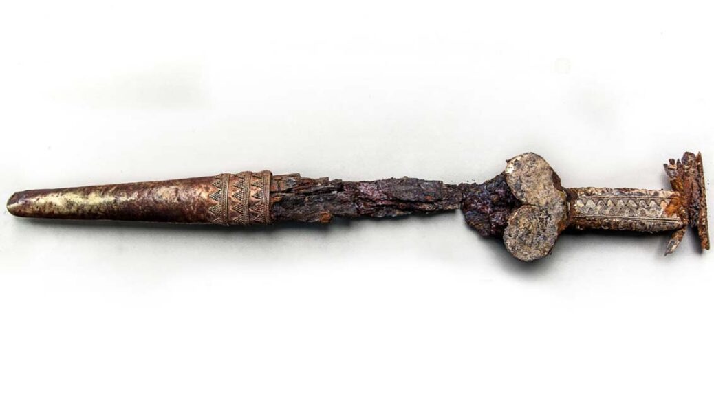
He was interred with a rare large grey clay amphorae, fittings from a horse’s bridle, an iron battle axe, bronze and bone arrows and the star of the funerary show: an akinakes (a Scythian dagger or short sword) with a gold plated scabbard, a grip with a leaf motif and a cross-guard with granulation details.
Ornaments and amphora were found at the site where the sword was found.
Not only had the young warrior been buried together with his weapons, but also with some ornaments; the archaeological team found beads made of glass paste, a red deer tooth necklace, a gold earring and a gold pendant with chalk inlay.
The Mount Mamai burial grounds, the largest barrow cemetery in the region and one of the largest in Europe, have been excavated for 32 years, a long-term salvage operation to recover as much archaeological material as possible before the site is destroyed by erosion from the construction of the Khakhovka Reservoir.
Already a quarter mile of the shore has fallen into the lake in just three decades, so archaeologists are fighting a battle against time.
Artefacts and remains dating as far back as the Neolithic era through the Middle Ages have been unearthed there. Of the 700 burials thus far excavated, around 400 are Scythian.
The leaf-ribbed grip, cross-guard of the Scythian short sword.
The discoveries made this season are so exceptional the 32nd dig has been dubbed the most successful yet. The very fine grave goods would be more than significant on their own, but the burial is even more notable because it dates to the 6th century B.C., making it the earliest Scythian burial found at Mount Mamai and extending the window of the cemetery’s usage during the Scythian period.
The other Scythian tombs that have been excavated there are at least two centuries older.
The objects have been cleaned and will be conserved at the Museum of Local History in Kamianets-Dniprovsky.
Jackpot: 900-Year-Old Gold Coins, Dating Back to The Crusades, Found in Israel
Archaeologists in Israel have uncovered a trove of rare gold coins and a 900-year-old gold earring at the site of a Crusader massacre. Officials announced the discovery earlier this week, explaining that the artefacts were found at the ancient city of Caesarea on Israel’s coast.
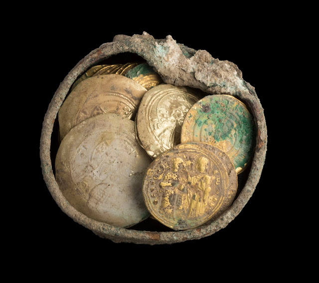
A small bronze pot, which contained 24 gold coins and the earring, was found hidden between two stones in the side of a well located in the remains of a 900-year-old house.
“The coins in the cache dating to the end of the eleventh century, make it possible to link the treasure to the Crusader conquest of the city in the year 1101, one of the most dramatic events in the medieval history of the city,” explained excavation directors Dr. Peter Gendelman and Mohammed Hatar of the Israel Antiquities Authority, in a statement.
Citing contemporary sources, the experts noted that most of Caesarea’s inhabitants were massacred by a Crusader army led by King Baldwin I of Jerusalem.
“It is reasonable to assume that the treasure’s owner and his family perished in the massacre or were sold into slavery, and therefore were not able to retrieve their gold,” they said in the statement.
The bronze pot with gold earrings inside.
The stunning artefacts were found in the area of a sacred compound built by King Herod the Great more than two millennia ago. Other treasures have also been found nearby. In the 1960s, for example, a pot containing gold and silver jewellery was discovered at Caesarea, while a collection of bronze vessels was found in the 1990s.
The house where the latest treasures were found was built about 1,000 years after Herod’s reign.
The turbulent Crusader era in the Holy Land began in the 11th century and lasted until the 13th century.
The excavation project at Caesarea is sponsored by the Edmond de Rothschild Foundation and involves the Caesarea Development Corporation, the Israel Nature and Parks Authority, as well as the Israel Antiquities Authority.
The discovery also came just before the Jewish holiday of Hanukkah, when it is traditional to give children “Hanukkah gelt,” which are chocolate coins.
“It is symbolic that the gold coins were discovered on the eve of Hanukkah,” said Caesarea Development Corporation CEO Michael Karsenti, in a statement. “For us, this is certainly ‘Hanukah gelt,’ and a testament to how much more is still hidden within Caesarea.”
Israel’s Crusader sites continue to be a source of fascination. In a separate project, for example, archaeologists recently discovered a Gothic hall at a medieval Crusader fortress in northern Israel.
Last year, amazing medieval jewellery was found during the excavation of a Crusader castle on Tittora Hill in the town of Modi’in-Maccabim-Re’ut.
In 2016, a centuries-old hand grenade that may date back to the time of the Crusaders was among a host of treasures retrieved from the sea in Israel. The hand grenade was a common weapon in Israel during the Crusader era.
Over decades, archaeologists have also uncovered the ruins of the once-thriving Crusader city in the modern Israeli city of Acre.