How pharaoh Khufu boat was found ‘perfectly preserved’ near the Great Pyramid
Archaeologists in Egypt have discovered a boat, which believed to have been used by Pharaoh Khufu himself “perfectly preserved,” which helped confirm theories over how the ancient society constructed their wonders.
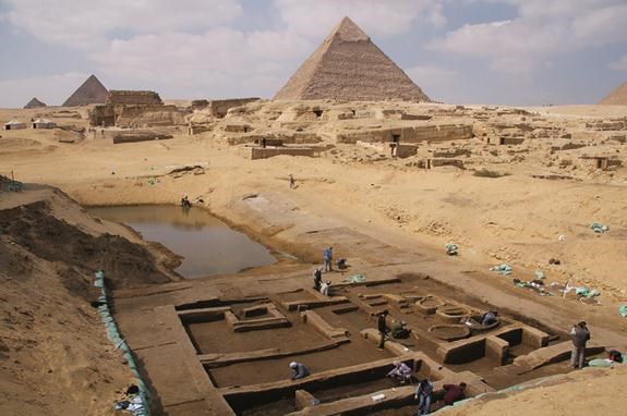
Probably the most famous and well-known of the many ancient landmarks of Egypt, the Giza pyramid complex is comprised of the Great Pyramid of Giza, the Pyramid of Khafre, and the Pyramid of Menkaure, together with their associated pyramid complexes and the Great Sphinx of Giza.
Of the three pyramids that still stand today, the Great Pyramid of Giza, or the Pyramid of Khufu, remains a spectacle to people all over the world, who marvel at how a society over 4,500 years ago managed to build such a colossal structure.
However, thanks to a find made more than half a century ago, archaeologists were able to slowly piece together what this ancient civilisation may have looked like and the ingenious way they worked together.
The 2014 series explained: “On this plateau, set on the edge of the desert, the story of the pyramids achieved its finest hour. “It is here that we best appreciate the grandeur and majesty of these constructions, and the organisational skills and methods used to erect them.

“The workers here were organised into teams that hauled blocks of stones on huge sledges mounted on logs of wood.
“Each team was made up of about 1,000 men organised along military lines and led by a master mason and various underlings.
“They were not slaves, they earned a regular wage, bed, and board and it is thanks to their work that these immense structures were ever completed.” The series continued, explaining the clever tactics used by the ancient society to haul together in the building process.
It added: “Even today, such imposing buildings would involve complex engineering problems.
“The Great Pyramid of Cheops, which was the first one to be built in Giza around 2500BC, has a base that covers over 12 acres (48,500 square metres).
“More than 2,300,000 blocks of stone were needed to build the base and weighed between two and 200 tonnes each.
“It may sound incredible, but this was once a lush green land, with neither desert nor buildings.
“Irrigation canals linked the areas to the Nile, and some of the stones used in buildings were transported on these canals.” The documentary went on to reveal how evidence of this was discovered more than 50 years ago.
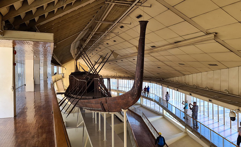
It added: “A boat made with cedarwood built almost 5,000 years ago was discovered here in 1954 near the Pyramid of Cheops, still in a perfect state of preservation.


“Archaeologists found it belonged to the pharaoh Cheops himself, 140 feet long, equipped with 12 oars and was probably used by Cheops when he travelled along the Nile.
“On those occasions, his subjects could get a glimpse of their Pharaoh and pay homage to him.”
At completion, the Great Pyramid was surfaced with white “casing stones” — slant-faced, but flat-topped, blocks of highly polished white limestone. However, in 1303, a massive earthquake loosened many of the outer casing stones, which were taken away 50 years later to be used in the building of mosques and fortresses in Cairo.
Many other theories have been proposed regarding the pyramid’s construction techniques, disagreeing on whether the blocks were dragged, lifted, or even rolled into place. The Greeks believed that slave labour was used, but modern discoveries made at nearby workers’ camps associated with construction at Giza suggest it was built instead of thousands of skilled workers.
Czech archaeologist, Miroslav Verner, claimed that the labour was organised into a hierarchy, consisting of two gangs of 100,000 men, divided into five zaa or phyle of 20,000 men each, which may have been further divided according to the skills of the workers.