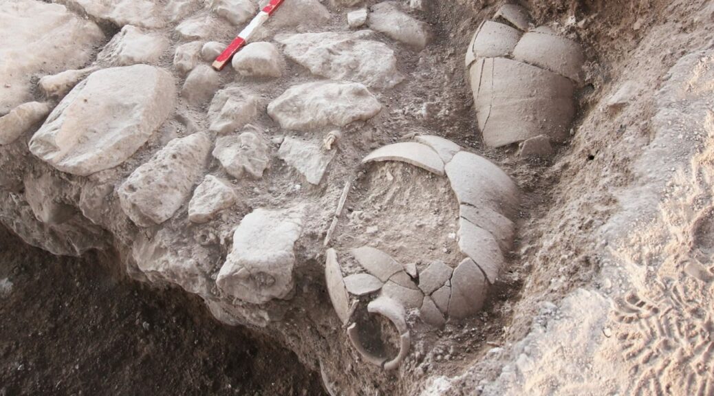
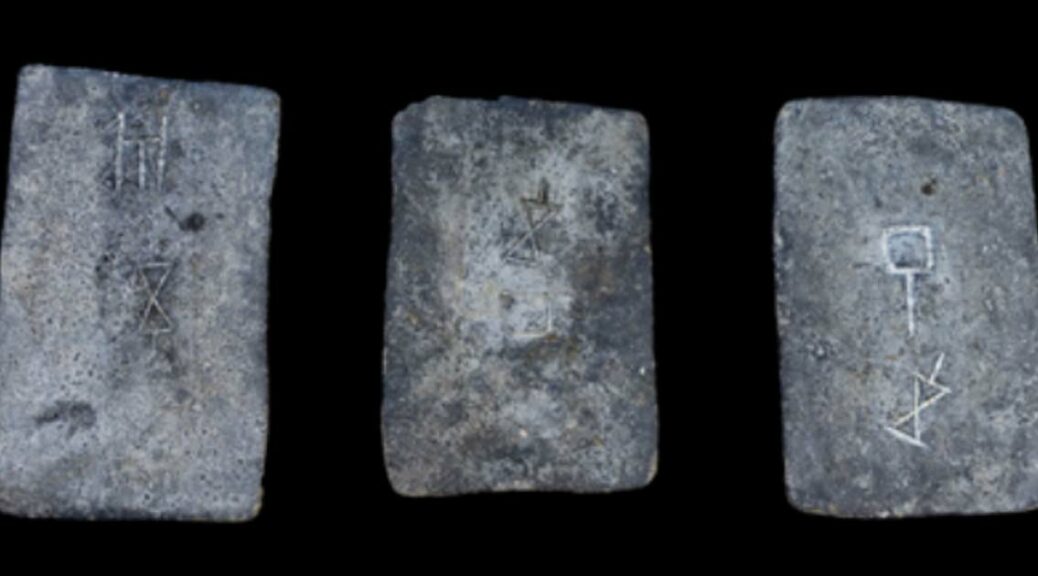
Archeologists at Tel Abel Beth Macaah, a joint dig between Azusa Pacific University and the Hebrew University of Jerusalem, have recently exposed a nearly 3,000-year-old jar with the Hebrew inscription.
The ink inscription reads “lbnayo,” meaning “belonging to Benaiyo.” This implies that an Israelite man named Benaiyo lived in Abel Beth Macaah around the 9th century B.C.
This is significant because it is the northern Israelite equivalent of a name found in the Bible (see 2 Samuel 23:20; 1 Chronicles 27:5; 1 Kings 1:8) and indicates that the site may have indeed been an Israelite city at this time (see 2 Samuel 20:29). The name means “Yahweh has built”.
The ink inscription reads “lbnayo,” meaning belonging to Benaiyo, an Israelite name
“Such a discovery advances our understanding of the site and the local region considerably,” said Robert Mullins, Ph.D., co-lead archaeologist of the dig site and chair and professor in Azusa Pacific’s Department of Biblical and Religious Studies.
The jar was found in the lower part of the city, where the team has already found remains from the 9th century, the time of King Ahab.
The new section of the site, Area K, had very little occupation from later periods, which allowed the archaeologists to quickly go below the topsoil and unearth a room containing several broken jars.
The team did not notice the inscription on the jar at first, but when the item was sent for restoration, faint traces of ink on one of the pieces were detected.
The Hebrew script was deciphered through multispectral images taken at the same lab in the Israel Museum that studies the Dead Sea Scrolls. “Any time you find writing on artifacts, that’s important because it can tell us so much about the history of the area,” Mullins said.
One of the other jars had a grape pip and residue in it, indicating the vessel was used to store wine, and the room may have been used for wine storage. Mullins said the team expects to find much more in the area when they resume excavation this summer.
Mullins and the team of archaeologists have excavated ancient artifacts and buildings at the site every summer since 2012. Past finds include silver earrings and ingots, a stone seal, and a small faience head of an ancient king.
Each year, Mullins is accompanied by co-directors Naama Yahalom-Mack, Ph.D. and Nava Panitz-Cohen, Ph.D., from the Institute of Archaeology at Hebrew University, and their team of archaeologists and scholars, including students from APU and partner schools Cornell University, Trinity Evangelical Divinity School, Asbury Theological Seminary, and Indiana Wesleyan University.
Scientists find that tin found in Israel from 3,000 years ago comes from Cornwall, England.
Scientists have revealed tin ingots from more than 3,000 years ago found in Israel. They have established that ancient tin ingots found in Israel actually came from what is now modern-day Britain.
Archaeologists believe it shows that tin was transported over long distances about 3000 years ago. Moreover, the researchers may have solved the mystery of the origin of the tin that was so vital for Bronze Age cultures.
The origins of Bronze-age tin ingots have been investigated by researchers from the University of Heidelberg and the Curt Engelhorn Center for Archaeometry in Mannheim. Tin ingots from the Bronze Age discovered by marine archaeologists off the coast of Israel.
According to Phys.org, the researchers used “lead and tin isotope data as well as trace element analysis” to identify where the metal was originally mined. What they found was totally unexpected.
The researchers established that the “3,000-year-old tin ingots found in Israel are actually from Cornwall and Devon” reports the Daily Mail.
These areas are in southwest Britain and were the sites of tin mines until modern times. The experts then analyzed tin ingots that were found in Greece and Turkey and they discovered that they had also come from Devon and Cornwall.
The original discovery of the tin ingots.
Map of Eurasia showing the locations of the tin ingots mentioned in the study (green dots), other tin objects in the eastern Mediterranean and the Near East before 1,000 BC (yellow dots), and major and minor tin deposits.
Based on the findings it seems that the tin was formed into ingots and exported from Devon and Cornwall. Given the limited technology at the time and the lack of roads, the most plausible way for the ingots to have reached modern-day Israel was by sea.
It seems that “the British Isles had developed maritime trade routes with the rest of the world as early as the Bronze Age ” according to the Daily Mail. These trade routes were probably very complex and covered great distances.
Tin was essential for societies in the eastern Mediterranean and there would have been a great demand for high-quality tin, and this would have encouraged the development of international trade routes. This could have led mariners to travel great distances to secure the metal.
The trade-in tin ingots were probably very dangerous but also very profitable. Other materials that were likely traded along these international trade networks were amber, copper, and luxury items. The fact that Bronze Age merchants could trade over vast distances shows that they were proficient sailors.
Bronze age artifacts which tin was vital for production.
The findings of the research are very important and allow us to have new insights into the trade in the distant past. It identifies for the first time the origin of the tin, that was so important in the Bronze Age.
It strongly indicates that international trade was much more advanced, 3,000 years ago, than widely supposed. The results could also guide archaeological research in the future.
Thanks to Heavy Rains: Ritual Baths for Temple now fully functional for first time in 2,000 years
Two thousand years ago, Jews from all over Israel attended the Holy Temple in Jerusalem three times a year to worship God, as the Bible commands
Three times a year—on the festival of Pesach, on the festival of Shavuot, and on the festival of Sukkot—all your males shall appear before Hashem your God in the place that He will choose. They shall not appear before Hashem empty-handed, Deuteronomy 16:16
In the course of their spiritual preparation for the encounter of holiness on the site of Temple, these pilgrims will immerse themselves in the mikvah.
An ancient mikvah, located just south of Jerusalem, that was used by these pilgrims has been renewed by the recent rainfall in Israel and is full enough to use, according to Assaf Brezis The Gush Etzion ATV Tour Manager
The ancient mikvah, located on the road known as Derech HaAvot (Patriarch’s Route), was rediscovered just 35 years ago.
While it’s still being run by the military and not fully restored, Brezis spoke excitedly about the Biblical significance of the mikvah and the area surrounding it. He knows it has the potential to captivate Bible-based Jews and Christian alike.
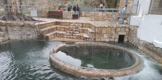
Ritual Bath in the Prat Spring, Judea
He knows because he’s witnessed visitors crying at the site, as they come to understand its Biblical significance. Brezis has a vision for building a tourist attraction near the mikvah, to reenact the scenes that took place there more than 2000 years ago.
Using speakers in each all-terrain vehicle, Brezis’ company takes visitors on tours, each lasting an hour or two, during which they are introduced to the history and Biblical significance of the mikvah and the surrounding area.
The ancient mikvah on Derech HaAvot, for example, has two entrances, separated by a wall in the center. This is different from most mikvahs, both ancient and modern, which are just a single pool.
Ancient mikvah with two entrances
Brezis told Breaking Israel News that there is a similar mikvah in what is today known as the Davidson Center in Jerusalem’s Old City. This type of construction is a clue that the mikvah was in heavy use by Jews on their way to Jerusalem.
When he gets visitors to imagine a time that the area around the mikvah was once “crowded with thousands of pilgrims together,” it often brings them to tears.
In addition to the ancient mikvah, the ATV tours bring people to other sites of Biblical significance nearby, such as Herodian (where King Herod is buried), Sde Boaz (Boaz’s field) where significant episodes from the Book of Ruth occurred, Roman milestones on roads to Jerusalem that were in use 4000 years ago and Mitzpor HaElef, a lookout more than 3000 feet above sea level.
The Talmud suggests that people who were coming to the Holy Temple could immerse themselves in a mikvah as soon as they felt the spiritual pull of Jerusalem. Brezis explained that it was common for pilgrims coming from the south to already sense Jerusalem at this location, making it a particularly well-known and heavily-used mikvah.
It is still possible today to see Jerusalem from the nearby Jewish community of Neve Daniel. Brezis connected this location to Avraham’s vision of Jerusalem on his journey to fulfill God’s command to sacrifice his son Yitzchak (Isaac).
On the third day Avraham looked up and saw the place from afar. Genesis 22:4
Shannon Nuszen, the political activist in the area, told Breaking Israel News that the site also has contemporary political significance. “I take [people on] tours there because it’s significant to the political fight here.
Derech HaAvot runs right through Judea and is full of archaeological finds that prove this land has always been Jewish. Just steps from the mikvah is a wine press and an ancient Roman milestone.
“While you’re standing there, you can look up and see the community of Netiv HaAvot, located on the same road where 17 homes were destroyed in the legal battle where claims were made that the land may or may not belong to us.”
Since the mikvah hasn’t yet been fully restored, the rainwater-filled pools may only last a few weeks, during Israel’s rainy season. Nevertheless, Brezis concluded that “It’s amazing to see this place, even without the water.”
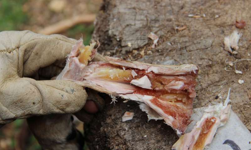
Prehistoric humans ate bone marrow like canned soup 400,000 years ago
A new study has found that prehistoric humans have preserved bone marrow in their caves for up to nine weeks as a soup pot.
Researchers previously thought that Paleolithic people lived a hand-to-mouth existence but this research shows they were sophisticated enough to preserve meat using bones like we use modern-day cans.
The research shows this took place in Qesem cave in what is now Tel Aviv between 420,000 and 200,000 years ago. According to the study published in Science Advances, it is the earliest evidence of delayed food consumption in the world.
The earliest evidence of delayed food consumption
Professor Ran Barkai of the university in Tel Aviv, who was involved in research, said, “The bones were used as ‘ cans ‘ that preserved the bone marrow for a long time until it was time to take off the dry skin, shatter the bone and eat the marrow.
“Bone marrow constitutes a significant source of nutrition and as such was long featured in the prehistoric diet.
“Until now, evidence has pointed to the immediate consumption of marrow following the procurement and removal of soft tissues. In our paper, we present evidence of storage and delayed consumption of bone marrow at Qesem Cave.”
Inhabitants of the cave brought in selected body parts of hunted animal carcasses.
“The most common prey was fallow deer, and limbs and skulls were brought to the cave while the rest of the carcass was stripped of meat and fat at the hunting scene and left there,” said Professor Jordi Rosell from the Catalan Institute of Human Paleoecology and Social Evolution (IPHES).
Researchers found deer leg bones had specific chopping marks on them which do not look like marks left from stripping fresh skin.
They believe the bones were left covered in the skin to help preserve them until they needed the meat.
Scientists have also found people regularly used fire, cooked and roasted meat in Qesem Cave.
“We assume that all this was because elephants, previously a major source of food for humans, were no longer available, so the prehistoric humans in our region had to develop and invent new ways of living,” said Professor Barkai.
“This kind of behavior allowed humans to evolve and enter into a far more sophisticated kind of socio-economic existence.”
The cave was discovered 15 years ago during the construction of a road to Tel Aviv.
A 2010 study into the traces caused controversy in the archaeology world as it questioned the theory of Homo sapiens originating in Africa, but the archaeologists were unable to draw a concrete conclusion from the evidence.
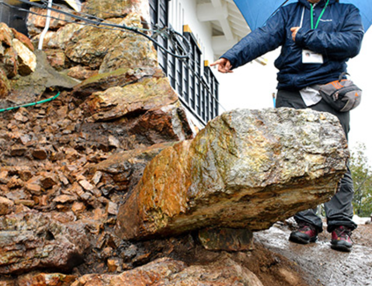
Stonewall points to Japan’s oldest castle keep built by Nobunaga
This seems like another pile of rocks to the uninitiated. But stones unearthed here apparently constitute part of the oldest castle keeps ever built in Japan. The stones form part of the top section of the base of a Gifu Castle keep likely built by legendary warlord Oda Nobunaga (1534-1582).
The Gifu Castle keep is seen in the background of a statue of Oda Nobunaga in Gifu Park.
Gifu Castle
The discovery was made last October and is regarded as significant in the study of castle building in Japan.
City officials, revealing the discovery on Jan. 7, said it is the first time researchers have identified what they believe was part of the original keep.
The hilltop castle was captured by Nobunaga during the Warring States period (late 15th to late 16th centuries).
The castle was renamed from Inabayama Castle after Nobunaga defeated its lord, Saito Tatsuoki, in 1567. He also renamed the region, then called Inokuchi, Gifu.
Luis Frois, a Portuguese missionary who visited the site two years after the takeover, wrote, “There was a gorgeous Japanese-style guest room (at the castle on the mountain),” according to the city’s education board.
A detailed image of the stone wall, including the base of the keep, is depicted in a drawing dating to the Genroku Era (1688-1704).
Stone walls of a keep are depicted in a drawing of the castle made during the Genroku Era (1688-1704) of the Edo Period (1603-1867).
However, it had been believed that most of the original wall was long gone, as the structure was torn down during reconstruction work in 1910.
The excavation work covers an area of about 1,410 square meters atop Mount Kinkasan.
Team members decided to excavate around a stone sticking diagonally out of the ground near a wall where the rebuilt structure stands. After digging out about five square meters, the members found what is believed to be the original stone wall.
An excavated stone wall in Gifu believed to have been built under Oda Nobunaga. The excavation team started digging around a stone, center, sticking diagonally out of the ground.
The section, about 1.8 meters long and 70 centimeters high, has three levels and is located above a layer at the northwestern corner that was created during the Warring States period.
The team also found a piece of stone that supports the bottom of the corner as well as areas where the stones were joined with mazumeishi pebbles to fill the gaps, matching the characteristics of walls built under Nobunaga.
In the castle drawing, a four-meter-high stone wall is depicted above the three layers of stone walls in the vicinity of the one recently discovered.
“We will continue our research to uncover all of the details,” said Mayor Masanao Shibahashi.
Hitoshi Nakai, a professor of history of castle building in Japan at the University of Shiga Prefecture, said the discovery will shed light on the history of castle building, particularly how feudal-era keeps originated.
Nakai added that similar techniques were used for building stone walls at Azuchi Castle, and noted that the same might be true for Sakamoto Castle, where a subordinate of Nobunaga, warlord Akechi Mitsuhide (1528-1582), resided.
Farmer Digging a well find the Terracotta Army of Emperor Qin Shi Huang in China
When farmers Yang Zhifa found a piece of an old terracotta as he dug a well, he thought he’d stumbled on a disused kiln that could supply him with free jars. How wrong he was: it turned out to be the first warrior of the famous Chinese terracotta army.
It was in the Chinese New Year in March 1974 and was especially dry in that time, Yang’s production unit decided to dig a well to water the crops of the cooperative farm.
“At first the digging went well. The second day we hit hard red earth. The third day, my hoe dug out the neck of a terracotta statue without a head, but the opening at the bottom was about the size of a bowl,” he recalled.
When archaeologist Zhao Kangmin picked up the phone in April 1974, all he was told was that a group of farmers digging a well nearby had found some relics.
“I commented to my workmate that it was probably the site of an old kiln. He advised me to dig carefully so that we’d be able to dig out any old jars and take them home for our own use.”
As they went on digging, the peasants came across the shoulders and torso of a statue. So it evidently wasn’t a kiln, they thought, but a temple. Then they realised that it was a complete body, apart from one leg that had been cut off, and the missing head. As they went on digging, they turned up bronze items. One of Yang’s colleagues teased him: “You like a nice pipe, and these things will be worth quite a bit of money. You’ll be able to swap them for tobacco.”
Suspicious villagers
“It was the middle of the Cultural Revolution at the time, and everything was topsy-turvy in the villages. People had gathered round and were watching us. When the older ones saw these ‘statues of gods’ and the bronze objects we had dug up, they weren’t at all pleased. They said they were part of the local feng shui, and that digging them up would do no good either to the village or to us.” But Yang had spent six years in the army and knew something about ancient objects.
“People had always said that the tomb of the Qin emperor covered an area of just over 9 hectares and that our village was about two kilometres from the mausoleum. These objects could be of historic interest. So I called some women and harnessed up three two-wheeled carts to transport them […] to the Lintong district museum several kilometres away.“
Yang wasn’t too sure what the museum would say about his find. “If they aren’t of any historic interest, I’ll throw them into the river, have a wash and go home,” he thought as he and his colleagues transported their unusual load. The experts at the museum recognised the fragments and the “statue of the god” as dating from the Qin dynasty – the third century B.C. – and that they were therefore extremely valuable.
“They paid us CNY10 (yuan) per cart, so a total of CNY30. We were really happy to get so much for having brought three carts of terracotta,” said Yang. At the time CNY10 was the equivalent of an annual salary in poor rural areas.
When they got back to the village they handed the money to their production unit, as was required under the collective system. Each one of them was awarded five points – the equivalent of half a day’s work – or 13 fen (a fen being a hundredth of a yuan) that they could use to buy food or other goods. At first, that was their entire reward.
Hour of glory
Yang Zhifa is one of the discoverers of the Mausoleum of the First Qin Emperor
Archaeologists at the site in 1979 – Zhao is not pictured
The authorities then decided to build a museum on the site of the mausoleum. The villagers – including Yang – were displaced. He received 5,000 yuan in compensation for his 167 square metres of land.
He moved to a new village, called Qinyong (meaning “Qin warriors”), six kilometres from the museum. He was given a three-room flat, similar to the ones allocated to other relocated villagers. But they were angry with him: if they had to leave their homes it was “because of him”, he explained. To get away from their hostile looks and remarks, he moved about a kilometre away.
When he thinks about it now, it didn’t really make much difference to his life. But he says that the discovery of the site and the reforms introduced by the authorities led to a rise in the standard of living and some of the villagers have been able to make money by setting up businesses.
But Yang doesn’t have a head for that sort of thing. The museum gave him job signing autographs for visitors. “At first I was earning CNY300 a month. By the time I retired it was 1,000.” Yang had his hour of glory when Bill Clinton visited the museum and asked for his autograph. The former US president isn’t the only world leader Yang met. He can’t remember all the names, but he has their photos on his wall. At the end of March 1990, Swiss photographer Daniel Schwartz, together with an assistant and a technician from Hong Kong, travelled to Lintong to.
Philosophical
When he stopped working at the museum, Yang found himself with practically no income. But he is philosophical about it.
“Whether it’s fair or not, I can’t do anything about it. I’m only a simple peasant,” he commented, but he is not unhappy either. “There were too many people at the museum. Sometimes I didn’t feel too well after working all day.” The museum now draws millions of visitors a year and earns some CNY480 million from them (about CHF72 million).
But few people still remember Yang. His name does not even appear on the explanatory board at the entrance to the display, which says simply that the terracotta army was discovered by local peasants. The People’s Daily wrote that “peasants don’t know anything about science. It’s impossible that they should have discovered anything,” said Yang.
“That’s life. Even if there is a lot of injustice in society, there’s no point in getting angry about it.” And as he pointed out, the discovery of the “eighth wonder of the world” may not have made him rich, but it still makes him proud.
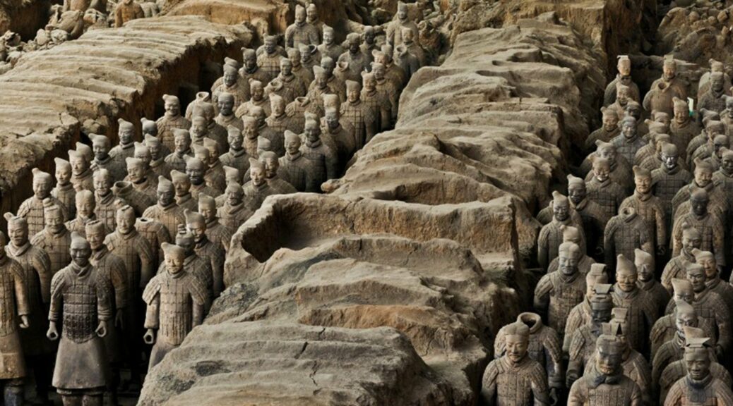
There Are 8,000 Known Terracotta Warriors. But Archaeologists in China Just Found More Than 200 Others
At the tomb of Emperor Qin Shi Huang, nearly 200 more warriors from the ancient China Terracotta Army were unearthed.
The remains of the two chariots, 12 clay horses, bronze swords, arcades and decorative helmets on the site were also found by archeologists.
During the recent excavations of the No. 1 pit in an area covering 400 square meters (4 300 square feet), the finding, which was confirmed by the state-run Xinhua News Agency.
Most of the newly-found warriors were divided into two groups. One group is carrying poles, while the other carries bows, by Shen Maosheng who led the digging.
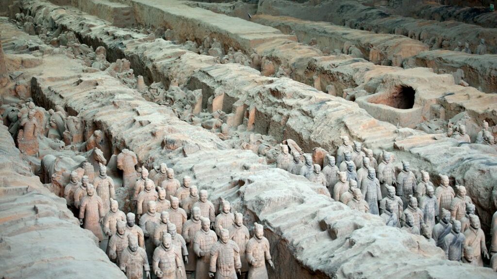
The Terracotta Army was built around 2,200 years ago to protect Emperor Qin Shi Huang in the afterlife. The army, which consists of an estimated 8,000 soldiers, over 500 horses and 130 chariots, was assembled in three main pits near to the emperor’s mausoleum.
The 2,200-year-old Terracotta Army at the Qin Terracotta Warriors and Horses Museum in 2005.
It was first discovered in 1974 by farmers digging in northwest China. Excavations soon revealed a huge complex with thousands of soldiers, each with individual features.
The tomb is believed to span around 38 square miles and, along with the Terracotta Army, contains a mass grave of laborers and craftsmen. The complex is believed to have taken around 30 years to build.
Archaeologists launched a new excavation at No.1 Pit in 2009. The 200 new warriors were found as part of this effort. This project aimed to better understand the military service system and equipment used by the Qin Dynasty army.
According to Xinhua, No.1 Pit contains 6,000 clay warriors and horses. It is estimated to be 750-feet long and 200-feet wide.
Scientists are still working to understand how this vast army was created. Last year, researchers led by Marcos Martinon-Torres, from the Department of Archaeology at the U.K.’s University of Cambridge, announced that the weapons at the site had been remarkably well-preserved because of the natural conditions in the pits where they were buried. Previously, it had been suggested that they had been coated in some sort of advanced, anti-rust technology.
“In some ways the Terracotta Army feels like an extraordinary playground for archaeologists: It is large, complex, well-preserved, meticulously excavated and great fun,” he told Newsweek at the time. “It raises countless questions that demand tailor-made collaborative approaches and keep all of us amused.”
While the Qin Dynasty lasted just 15 years, it was the first time China was ruled as a unified country. As well as the Terracotta Army, Emperor Qin Shi Huang was also responsible for the construction of the Great Wall of China.
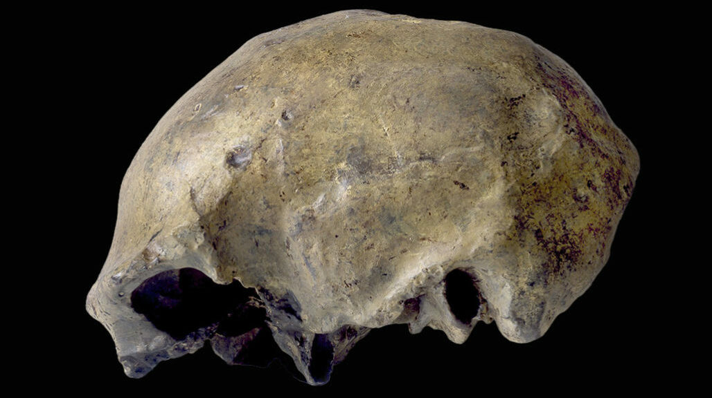
Homo erectus’ last known appearance dates to roughly 117,000 years ago
A new study finds that the last known appearance of Homo erectus, at Java’s Ngandong site, dates to between 117,000 and 108,000 years ago. A H. Erectus skullcap previously found at the site is shown.
Two million years ago the Homo erectus had evolved and became the first human species to be entirely upright. New evidence suggests it remained there on the Indonesian island of Java just over 100,000 years ago-long after it had disappeared elsewhere.
It means when our own species started living on Earth, it was still around. In the 1930s, 12 Homo erectus skull caps and two lower leg bones were found in a bone bed 20m above the Solo River at Ngandong in central Java.
In subsequent decades, researchers have attempted to date the fossils. But this proved difficult because the surrounding geology is complex and details of the original excavations became confused. In the 1990s, one team came up with unexpectedly young ages of between 53,000 and 27,000 years ago. This raised the distinct possibility that modern humans overlapped with Homo erectus on the Indonesian island.
Prof Russell Ciochon with replicas of the Homo erectus skull caps found at Ngandong
Now, researchers led by Prof Russell Ciochon of the University of Iowa in Iowa City opened up new excavations on the terraces beside the Solo River, reanalyzing the site and its surroundings.
They have provided what they describe as a definitive age for the bone bed of between 117,000 and 108,000 years old. This represents the most recent known record of Homo erectus anywhere in the world.
“I don’t know what you could date at the site to give you more precise dates than what we’ve been able to produce,” Prof Ciochon told LIVE SCIENCE.
Prof Chris Stringer, research leader on human evolution at London’s Natural History Museum, who was not involved with the work, commented: “This is a very comprehensive study of the depositional context of the famous Ngandong Homo erectus partial skulls and shin bones, and the authors build a strong case that these individuals died and were washed into the deposits of the Solo River about 112,000 years ago.
“This age is very young for such primitive-looking Homo erectus fossils, and establishes that the species persisted on Java for well over one million years.”
Researchers think the collection of remains represent a mass death event, possibly the result of a lahar upriver. A lahar – which comes from a Javanese word – is the slurry that can flow down the slope of a volcano when heavy rainfall occurs during or after a volcanic eruption. These violent events will sweep away anything in their path.
Previously, team-member Frank Huffman, from the University of Texas at Austin, had tracked down the descendants of the Dutch researchers who excavated the Homo erectus remains back in the 1930s.
The excavation sites lie along the Solo River in central Java
The relatives were able to provide him with photographs of the original dig, maps, and notebooks. Huffman was able to resolve much of the uncertainty that had hampered previous attempts to understand the site.
“He was able to tell us exactly where to dig,” Prof Ciochon said of the University of Texas researcher. Ciochon and his colleagues excavated part of an untouched reserve area left alone by the Dutch team in the 1930s. Informed by records of the original excavations, the team was able to identify the gravelly deposit – or bone bed – from which the Homo erectus fossils had come, and date it.
On other islands in South-East Asia, Homo erectus appears to have evolved into smaller forms, such as Homo floresiensis – the “Hobbit” – on Flores, and Homo luzonensis in the Philippines. This probably occurred because there were limited food resources on these islands. But on Java, there appears to have been enough food for Erectus to maintain its original body size.
The specimens at Ngandong appear to be between 5ft and 6ft in height – comparable to examples from Africa and elsewhere in Eurasia. The findings further underline the shift in thinking this field of study has undergone over the decades. We used to think of human evolution as a progression, with a straight line leading from apes to us. This is embodied in the so-called March of Progress illustration where a stooping chimp-like creature gradually morphs into Homo sapiens, apparently the apex of evolution.
Excavations at Ngandong in 2010
These days, we know things were far messier. The latest study highlights a mind-boggling truth: that many of the species we thought of as transitional stages in this onward march overlapped with each other, in some cases for hundreds of thousands of years.
But why did Homo erectus survive so late on Java? In Africa, the species was probably gone by 500,000 years ago; in China, it vanished some 400,000 years ago. Russell Ciochon thinks that it was probably outcompeted by other human species elsewhere, but Java’s location allowed it to thrive in isolation. However, the results show the fossils came from a period when environmental conditions on Java were changing. What was once open woodlands were transforming into the rainforest. Prof Ciochon thinks this could mark the exact point of extinction of Homo erectus on the island.
No Homo erectus is found after this time, he explained, and there’s a gap with no human activity at all until Homo sapiens turns up on Java around 39,000 years ago. Prof Ciochon believes H. Erectus was too dependent on the open savannah and too inflexible to adapt to life in a rainforest. “Homo sapiens is the only hominin species that live in a tropical forest,” he explained. “I think it’s mainly because of the cultural attributes of Homo sapiens – the ability to make all these specialized tools.”
“Once this rainforest flora and fauna spread across Java, that’s the end of erectus.”
But Chris Stringer sounded a note of caution.
“The authors claim that this is, therefore, the last known occurrence of the species and that this indicates there was no overlap of the species with Homo sapiens in Java, as H. sapiens arrived much later,” he said.
“I’m not convinced about that as other supposedly late Homo erectus material from Javanese sites like Ngawi and Sambungmacan remain to be properly dated, and they may be younger still. Alternatively, they may correlate with the ages of the Ngandong fossils, but that should be the next stage of an investigation.”