Over 2,000-year-old bronze mirrors unearthed at a cemetery in NW China
Xinhua reports that pottery and more than 80 delicate bronze mirrors and other bronze items have been discovered in a cemetery of more than 400 tombs in northwest China.
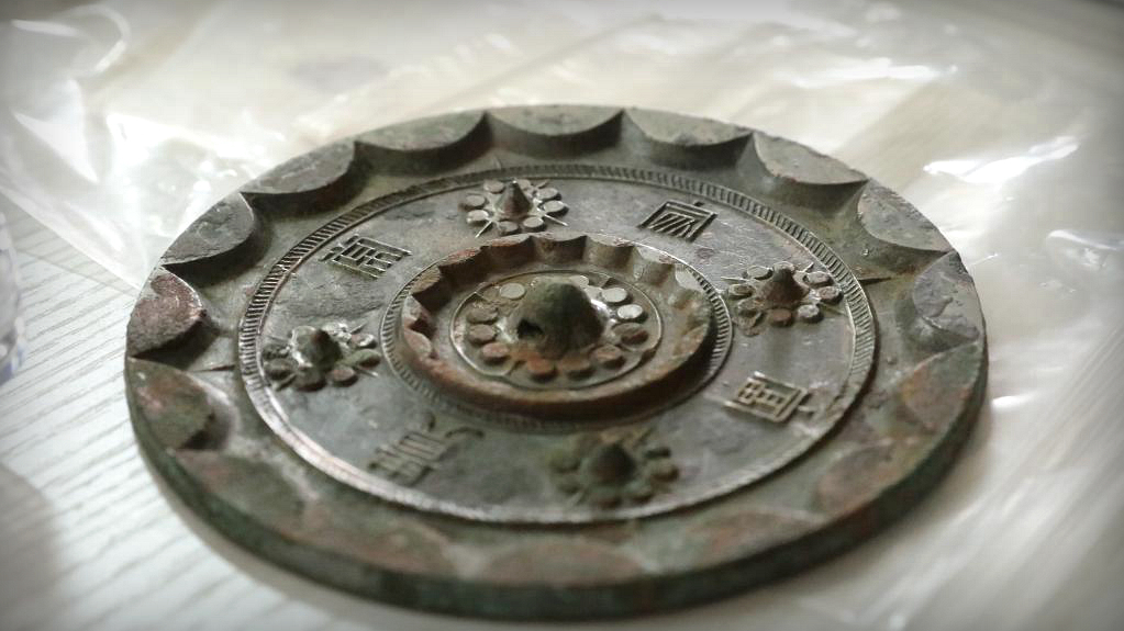
A bronze mirror shows exquisite patterns after cleaning in Xixian New Area, Shaanxi Province, northwest China.
Situated in the Gaozhuang Township of Shaanxi’s Xixian New Area, the graveyard is home to more than 400 tombs and a collection of pottery and bronze ware that can be traced back to the early Western Han Dynasty (202 BC-AD 25).
The bronze mirrors, with diameters ranging from 8 cm to 22.1 cm, were discovered during the recent excavation of the site, according to the archaeologists.
An archaeologist is cleaning a bronze mirror in Xixian New Area, Shaanxi Province, China.
They are believed to have been manufactured mainly between the late Warring States Period (475-221 BC) and the late Western Han Dynasty.
The high gloss of some mirrors was well preserved, as researchers found one still showed clear images.
Archaeologists carry out the excavation work at the Dabaozi Cemetery in Xixian New Area, Shaanxi Province, China.
The researchers also found that most of the mirrors were placed close to the head or around the upper body of the tomb owners, with inscriptions showing people’s expectations of a better life.
Not only did the women of yore enjoy their reflection, but also the men, as they were buried along with their delicate mirrors.
According to historical records, in order to ensure the construction and service of the emperor’s mausoleum as well as to better supervise the aristocrats, Liu Bang, founder of the Han Dynasty (206 BC-220 AD), set up a centralized residence area for the nobility, which was located about 4 km from the cemetery.
Therefore, the ancient tombs are believed to belong to the dynasty’s upper-class residents, said the researchers.
The Powerful Symbol of the Swastika and its 12,000 Year History
The swastika is a sign of the massacres of millions of people and the destructiveness of one of the most despised men on Earth. But it’s not Adolf Hitler who used the symbol first. It was actually utilized by many cultures and continents as a powerful symbol thousands of years before him.
The Swastika has been an important symbol for many thousands of years to the Hindus and Buddhists of India and other Asian countries, but the symbol is still visible in abundance – on temples, buses, taxis, and covers of books.
It was used in Ancient Greece as well and can be found in the ancient city of Troy that existed four thousand years ago.
A swastika is a symbol found in many cultures, with different meanings, drawn in different styles.
The ancient Druids and the Celts also used the symbol, reflected in many artefacts that have been discovered. It was used by Nordic tribes and even early Christians used the swastika as one of their symbols.
For example, the Teutonic Knights, a German medieval military order that became a purely religious Catholic order, used it. But why is this symbol so important and why did Adolf Hitler decide to use it?
The word “swastika” is a Sanskrit word (“svastika”) meaning “It is,” well being,” “good existence,” and “good luck.” However, it is also known by different names in different countries—like “wan” in China, “manji” in Japan, “fylfot” in England, “Hakenkreuz” in Germany and “tetraskelion” or “tetragammadion” in Greece.
Mosaic swastika in excavated Byzantine church in Shavei Tzion (Israel).
A Sanskrit scholar P.R. Sarkar in 1979 said that the deeper meaning of the word is “permanent victory.”
The earliest swastika ever found was uncovered in Mezine, Ukraine, carved on an ivory figurine, which dates an incredible 12,000 years, and one of the earliest cultures that are known to have used the swastika was a Neolithic culture in Southern Europe, in the area that is now Serbia, Croatia, Bosnia, and Herzegovina, known as the Vinca Culture, which dates back around 8,000 years.
In Buddhism, the swastika is a symbol of good fortune, prosperity, abundance, and eternity. It is directly related to Buddha and can be found carved on statues on the soles of his feet and on his heart. It is said that it contains Buddha’s mind.
Wooden Buddha statue with gamadian (swastika).
On the walls of the Christian catacombs in Rome, the symbol of the swastika appears next to the words “zotiko zotiko,” which means “life of life.” It can also be found on the window openings of the mysterious Lalibela Rock churches of Ethiopia, and in various other churches around the world.
In Nordic Myths, Odin is represented passing through space as a whirling disk or swastika looking down through all worlds. In North America, the swastika was used by the Navajos.
In Ancient Greece, Pythagoras used the swastika under the name “tetraktys,” and it was a symbol linking heaven and Earth, with the right arm pointing to heaven and the left arm pointing to Earth.
The swastika, the Phoenician sun symbol, on the Phoenician Craig-Narget stone in Scotland, and on the robe of a Phoenician high priestess.
It was used by the Phoenicians as a symbol of the sun and it was a sacred symbol used by the priestesses.
How and why did so many diverse countries and cultures, across many eras, use the same symbol and apparently with the same meaning? It is ironic, and unfortunate, that a symbol of life and eternity that was considered sacred for thousands of years has become a symbol of hatred.
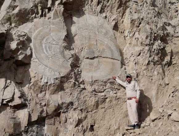
Over 67 million-year-old tree fossil found in Shimla district in India
A tree fossil estimated to be over 67 million years old has been found near Kharapathar in the district, an expert said on Thursday. The fossilised tree belongs to the Mesozoic era, Hari Chauhan, curator of State Museum and a fossil expert who visited the spot, said. The Mesozoic era is the age of dinosaurs, and lasted about 180 million years, from about 250 to 65 million years ago.
Rohru’s Divisional Forest Officer (DFO) Chandulal Tahsildar said he found the fossils during a site visit to the area in connection with complaints of illegal filling. He said frequent landslides that the area experienced recently could have brought the fossils to the surface.
“It was during my visit to the place on March 30 that I chanced upon these fossils that obviously seemed to look very old,” he said, adding that the tree stumps were nearly 11×8 feet and elliptical.
Himachal Pradesh: A tree fossil found in Kharapathar, Shimla district. According to Harish Chauhan, Curator State Museum the fossil belongs to the Mesozoic geological era.
Chauhan, who visited the site, said the discovery could either be tree fossils or geological formations.
“It’s a very important discovery either way,” he said, adding that such fossils, while not uncommon in the Shiwalik ranges, were rare in Himalayan ranges. Similar fossils have been found in Spiti.
“If it’s a tree fossil, it’s very important from the point of view of paleontological studies. And if it’s a geological formation, then it’s a crucial discovery in the field of geological studies,” he said, adding a team of geologists and forest officials would join him in thoroughly searching the area.
Meanwhile, the latest discovery will be protected.
About Fossils :
A fossil is the remains or trace of an ancient living thing. Fossils of animals, plants, or protists occur in sedimentary rock. In a typical fossil, the body form is retained, but the original molecules that made up the body have been replaced by some inorganic materials, such as calcium carbonate (CaCO3) or silica (SiO2). The fossil feels like, and is, made of rock. It has been mineralised or petrified(literally, turned into rock).
A fossil may also be an imprint or impression of a living thing remaining in the fossilised mud of a long-gone age. Some organisms fossilise well, others do not.
The most common fossils are those left behind by organisms that produce hard materials. The hard, calcitic shells of molluscs (such as clams and snails) and of now-rare brachiopods (also known as lampshells) are examples. These sea-dwelling shellfish have produced many fossiliferous (that is, fossil-bearing) chalky layers of limestone in the earth.
Soft-bodied organisms can fossilise in special circumstances: the Ediacaran biota is a good example. The best-known fossils for the general public are those of the giant, prehistoric dinosaurs. The fossilized bones and fossilized tracks of these huge, ancient reptiles can be seen in many museums of natural history and earth science.
The study of fossils by geologists and biologists is known as palaeontology. If the study puts living things in their ecological context it is called paleobiology.
Mesozoic Era :
The Mesozoic Era is the age of the dinosaurs and lasted almost 180 million years from approximately 250 to 65 million years ago. This era includes 3 well known periods called the Triassic, Jurassic, and cretaceous periods.
A mass extinction marked the beginning and end of the Mesozoic Era. The event that caused the transition from the Paleozoic era to the Mesozoic era was the greatest extinction this earth has seen. This extinction wiped out about 95% of all marine life and 70% of land life. This allowed the dinosaurs to step in and settle into their role as the lords of the earth. The era ended with “The Great Extinction” which marked the end of the dinosaurs as the Cenozoic era began.
Tectonics :
At the beginning of the Mesozoic era, the continents as we know them were joined together as the massive mother continent, Pangaea. It was during the age of the dinosaurs that Pangaea was transformed into the modern continents.
Pangaea became two great continents known as Laurasia and Gondwana and the Atlantic Ocean began to grow. Laurasia eventually split into the continents of North America and Eurasia. Gondwana became the modern continents of South America, Africa, Australia, Antarctica, and the Indian subcontinent, which, after the Mesozoic era, collided with Eurasia forming the Himalayas.
Environment :
The environment was unusually warm and polar ice caps did not yet exist. This played a large part in the evolution and is a key factor behind the flourishing of the dinosaurs.
During the Triassic period, the climate was generally dry, which changed near the Jurassic period as oceans began to rise due to mounting layers of magma covering the seafloor. As a result, flooding overtook many parts of the exposed land.
This allowed the climate to change with increased humidity and it continued that way even into the Cretaceous period. However, the climate began to cool during the Cretaceous although temperatures may have risen again near the end of the Mesozoic.
Monumental Neolithic Tomb Discovered in Saudi Arabia
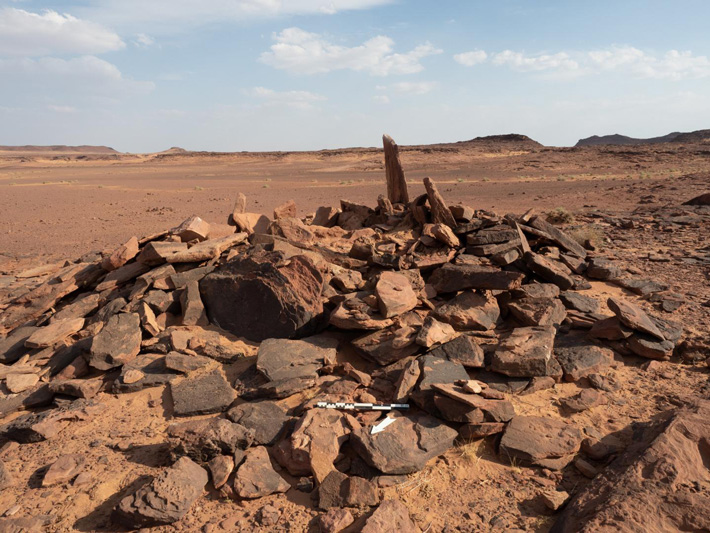
According to a statement released by Taylor & Francis, the remains of a dog and 11 people have been found in a monumental tomb near the archaeological site of Al-Ula, which is located in northwestern Saudi Arabia.
The discovery came from one of the projects in the large-scale archaeological surveys and excavations of the region commissioned by the Royal Commission for AlUla (RCU).
The researchers found the dog’s bones in a burial site that is one of the earliest monumental tombs identified in the Arabian Peninsula, roughly contemporary with such tombs already dated further north in the Levant.
This burial site in a badlands area of AlUla in north-west Saudi Arabia is currently rare for Neolithic-Chalcolithic Arabia in being built above-ground and meant to be visually prominent.
Evidence shows the earliest use of the tomb was circa 4300 BCE and received burials for at least 600 years during the Neolithic-Chalcolithic era – an indication that the inhabitants may have had a shared memory of people, places, and the connection between them.
“What we are finding will revolutionize how we view periods like the Neolithic in the Middle East. To have that kind of memory, that people may have known for hundreds of years where their kin was buried – that’s unheard of in this period in this region,” said Melissa Kennedy, assistant director of the Aerial Archaeology in the Kingdom of Saudi Arabia (AAKSAU) – AlUla project.
“AlUla is at a point where we’re going to begin to realize how important it was to the development of mankind across the Middle East,” said the AAKSAU director, Hugh Thomas.
This is the earliest evidence of a domesticated dog in the Arabian Peninsula by a margin of circa 1,000 years.
The findings are published in the Journal of Field Archaeology.
The project team, with Saudi and international members, focused its efforts on two above-ground burial sites dating to the 5th and 4th millennia BCE and located 130 kilometers apart, one in volcanic uplands and the other in arid badlands. The sites were above ground, which is unique for that period of Arabian history, and were positioned for maximum visibility.
The research team detected the sites by using satellite imagery and then by aerial photography from a helicopter. Ground fieldwork began in late 2018.
It was in the volcanic uplands site that 26 fragments of a single dog’s bones were found, alongside bones from 11 humans – six adults, an adolescent, and four children.
The dog’s bones showed signs of arthritis, which suggests the animal lived with the humans into its middle or old age. After assembling the bones, the team then had to determine that they were from a dog and not from a similar animal such as a desert wolf.
The team’s zooarchaeologist, Laura Strolin, was able to show it was indeed a dog by analyzing one bone in particular, from the animal’s left front leg. The breadth of this bone was 21.0 mm, which is in the range of other ancient Middle Eastern dogs. In comparison, the wolves of that time and place had a breadth of 24.7 to 26 mm for the same bone.
The dog’s bones were dated between circa 4200 and 4000 BCE.
Rock art found in the region indicates that the Neolithic inhabitants used dogs when hunting ibex, and other animals.
The fieldwork uncovered other noteworthy artifacts, including a leaf-shaped mother-of-pearl pendant at the volcanic uplands site and a carnelian bead found at the arid badlands site.
The researchers expect more findings in the future as a result of the massive survey from the air and on the ground, and multiple targeted excavations in the AlUla region undertaken by the AAKSAU and other teams, which are operating under the auspices of the Royal Commission for AlUla (RCU). The AAKSAU team is led by researchers from the University of Western Australia in Perth, Australia.
The researchers note that AlUla is a largely unexplored area located in a part of the world that has a fertile archaeological heritage of recognized global value.
“This article from RCU’s work at AlUla establishes benchmarks. There is much more to come as we reveal the depth and breadth of the area’s archaeological heritage,” said Rebecca Foote, Director of Archaeology and Cultural Heritage Research for RCU.
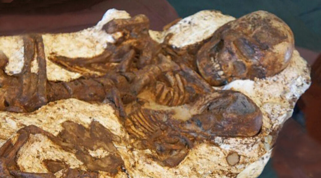
Mother Found Still Cradling Baby After 4,800 Years
It is a fitting discovery as Mother’s Day approaches. Archaeologists have uncovered the ancient remains of a young mother and an infant child locked in a 4,800-year-old embrace. The remarkable find was among 48 sets of remains unearthed from graves in Taiwan, including the fossils of five children.
The mother is seen looking towards the child
Researchers were stunned to discover the maternal moment, and they say these Stone Age relics are the earliest sign of human activity found in central Taiwan.
Preserved for nearly 5,000 years, the skeleton found in the Taichung area shows a young mother gazing down at the baby cradled in her arms.
Researchers turned to carbon dating to determine the ages of the fossils, which they traced back to the Neolithic Age, a period within the Stone Age.
Excavation began in May 2014 and took a year for archaeologists to complete. But of all the remains found in the ancient graves, one pair set stood out from the rest.
‘When it was unearthed, all of the archaeologists and staff members were shocked.
‘Why? Because the mother was looking down at the baby in her hands,’ said Chu Whei-lee, a curator in the Anthropology Department at Taiwan’s National Museum of Natural Science.
According to the researchers’ measurements, the mother was just 160 cm tall, or 5 foot 2 inches. The infant in her arms is 50 cm tall – just over a foot-and-a-half.
Archaeologists say they have discovered the earliest trace of human activity in central Taiwan among graves from 4,800 years ago
This breathtaking discovery came as a surprise to the researchers on sight, but it isn’t the first of its kind.
In the past, archaeologists have dug up remains of similar moments which have been preserved for thousands of years.
Notably, Chinese archaeologists unearthed the interlocked skeletons of a mother and child last year from an Early Bronze Age archaeological site branded the ‘Pompeii of the East, the People’s Daily Online reported.
The mother is thought to have been trying to protect her child during a powerful earthquake that hit Qinghai province, central China, in about 2,000 BC.
Experts speculated that the site was hit by an earthquake and flooding of the Yellow River.
Photographs of the skeletal remains show the mother looking up above as she kneels on the floor, with her arms around her young child. Archaeologists say they believe her child was a boy.
Japan’s Ancient Underwater “Pyramid” Mystifies Scholars
Submerged stone structures lying just below the waters off Yonaguni Jima are actually the ruins of a Japanese Atlantis—an ancient city sunk by an earthquake about 2,000 years ago. That’s the belief of Masaaki Kimura, a marine geologist at the University of the Ryukyus in Japan who has been diving at the site to measure and map its formations for more than 15 years. Each time he returns to the dive boat, Kimura said, he is more convinced than ever that below him rest the remains of a 5,000-year-old city.
“The largest structure looks like a complicated, monolithic, stepped pyramid that rises from a depth of 25 meters [82 feet],” said Kimura, who presented his latest theories about the site at a scientific conference in June. But like other stories of sunken cities, Kimura’s claims have attracted controversy.
“I’m not convinced that any of the major features or structures are manmade steps or terraces, but that they’re all-natural,” said Robert Schoch, a professor of science and mathematics at Boston University who has dived at the site.
“It’s basic geology and classic stratigraphy for sandstones, which tend to break along planes and give you these very straight edges, particularly in an area with lots of faults and tectonic activity.”
And neither the Japanese government’s Agency for Cultural Affairs nor the government of Okinawa Prefecture recognize the remains off Yonaguni as important cultural property, said agency spokesperson Emiko Ishida. Neither of the government groups has carried out research or preservation work on the sites, she added, instead of leaving any such efforts to professors and other interested individuals.
Ruins Point
Yonaguni Jima is an island that lies near the southern tip of Japan’s Ryukyu archipelago, about 75 miles (120 kilometres) off the eastern coast of Taiwan (see map). A local diver first noticed the Yonaguni formations in 1986, after which a promontory on the island was unofficially renamed Iseki Hanto or Ruins Point.
The district of Yonaguni officially owns the formations, and tourists and researchers can freely dive at the site. Some experts believe that the structures could be all that’s left of Mu, a fabled Pacific civilization rumoured to have vanished beneath the waves. On hearing about the find, Kimura said, his initial impression was that the formations could be natural. But he changed his mind after his first dive.
“I think it’s very difficult to explain away their origin as being purely natural, because of the vast amount of evidence of man’s influence on the structures,” he said.
As teams of expert divers fanned out from the south coast of Okinawa using grid-search patterns, they found five sub surface archaeological sites near three offshore islands. The locations vary at depths from 100 to only 20 feet.
For example, Kimura said, he has identified quarry marks in the stone, rudimentary characters etched onto carved faces, and rocks sculpted into the likenesses of animals.
“The characters and animal monuments in the water, which I have been able to partially recover in my laboratory, suggest the culture comes from the Asian continent,” he said.
“One example I have described as an underwater sphinx resembles a Chinese or ancient Okinawan king.” Whoever created the city, most of it apparently sank in one of the huge seismic events that this part of the Pacific Rim is famous for, Kimura said.
The world’s largest recorded tsunami struck Yonaguni Jima in April 1771 with an estimated height of more than 131 feet (40 meters), he noted, so such a fate might also have befallen the ancient civilization. Kimura said he has identified ten structures off Yonaguni and a further five related structures off the main island of Okinawa. In total, the ruins cover an area spanning 984 feet by 492 feet (300 meters by 150 meters).
The structures include the ruins of a castle, a triumphal arch, five temples, and at least one large stadium, all of which are connected by roads and water channels and are partly shielded by what could be huge retaining walls. Kimura believes the ruins date back to at least 5,000 years, based on the dates of stalactites found inside underwater caves that he says sank with the city.
And structures similar to the ruins sitting on the nearby coast have yielded charcoal dated to 1,600 years ago—a possible indication of ancient human inhabitants, Kimura added. But more direct evidence of human involvement with the site has been harder to come by.
“Pottery and wood do not last on the bottom of the ocean, but we are interested in further research on a relief at the site that is apparently painted and resembles a cow,” Kimura said.
“We want to determine the makeup of the paint. I would also like to carry out subsurface research.”
Natural Forces
Toru Ouchi, an associate professor of seismology at Kobe University, supports Kimura’s hypothesis. Ouchi said that he has never seen tectonic activity having such an effect on a landscape either above or below the water.
“I’ve dived there as well and touched the pyramid,” he said. “What Professor Kimura says is not exaggerated at all. It’s easy to tell that those relics were not caused by earthquakes.”
Boston University‘s Schoch, meanwhile, is just as certain that the Yonaguni formations are natural. He suggests that holes in the rock, which Kimura believes were used to support posts, were merely created by underwater eddies scouring at depressions. Lines of smaller holes were formed by marine creatures exploiting a seam in the rock, he said.
“The first time I dived there, I knew it was not artificial,” Schoch said. “It’s not as regular as many people claim, and the right angles and symmetry don’t add up in many places.”
He emphasizes that he is not accusing anyone of deliberately falsifying evidence. But many of the photos tend to give a perfect view of the site, making the lines look as regular as possible, he said.
Natural Formations
Schoch also says he has seen what Kimura believes to be renderings of animals and human faces at the site. “Professor Kimura says he has seen some kind of writing or images, but they are just scratched on a rock that is natural,” he said.
“He interprets them as being manmade, but I don’t know where he’s coming from.”
But Kimura is undeterred by critics, adding that the new governor of Okinawa Prefecture and officials from the United Nations Educational, Scientific, and Cultural Organization have recently expressed interest in verifying the site.
“The best way to get a definitive answer about their origins is to keep going back and collecting more evidence,” he continued.
“If I’d not had a chance to see these structures for myself, I might be skeptical as well.”
The 2,50-year-old rug is a wonderful reflection of the Advanced Culture of the Pazyryk Nomads
In 1948, Altai Mountains excavated the oldest hand-knotted oriental rug. It was discovered in the grave of the prince of Altai near Pazyryk, 5400 feet above sea level, and clearly shows how well hand-knotted rugs were produced thousands of years ago.
The Pazyryk carpet was woven in the 5th century B.C., making it approximately 2,500 years old, according to radiocarbon dating.
The advanced weaving techniques and the sophisticated design and construction, used in this rug, suggest the art of carpet weaving to go back much further than the 5th century B.C.. to be at least 4000 years old. Today the rug is in the Hermitage Museum in Leningrad, Russia.
Detail of the Pazyryk carpet from a replica in the Carpet Museum of Iran
When the prince of Altai died, he was buried in a grave mound with many of his prized possessions, including the Pazryk Carpet. Unfortunately, soon after, the grave mound was robbed of its prized possessions, with the exception of the rug.
The rug was semi-frozen because the thieves did not bother to cover up the hole they had dug to retrieve the items, rendering the hole exposed to the elements within the tomb.
The combination of low temperature and precipitation within the tomb subsequently froze the carpet, and preserved it in a thick sheet of ice, protecting it for twenty-five centuries. This somewhat ironic story is the reason that the Pazyryk rug still exists today.
Although it was found in a Scythian burial mound, most experts attribute the Pazyryk rug to Persia.
Pazyryk horseman. Circa 300 BCE. Detail from a carpet in the State Hermitage Museum in St Petersburg.
Its design is in the same style as the sculptures of Persepolis, The outer of the two principal border bands is decorated with a line of horsemen: seven on each side, twenty-eight in number — a figure which corresponds to the number of males who carried the throne of Xerxes to Perspolis. Some are mounted, while others walk beside their horses. In the inner principal band, there is a line of six elks on each side.
The extra figures inside the elks are depicting the inwards and the vertebra of the elk, all parts in real positions with nearly clinical precision:
1. The heart, just above the front legs (a yellow framed red sphere, black contoured).
2. The aorta (a long red protuberance on the heart).
3. The maw, on the right-hand side of the sphere (a large yellow area with a widening upwards on the end).
4. The intestine, in the rear end (a yellow square surrounded by a light blue and a yellow bow).
5. Possibly the urethra, on the upper part of the right hind leg (a yellow line with a black point), better to see on some others deer on the border.
6. The vertebra, directly below the brown back contour (an alternating black-white chain).
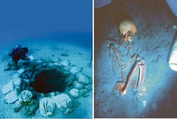
Atlit Yam, a 9,000-year-old underground megalithic settlement
On the Levantine coast, Atlit-Yam offers the earliest known evidence for an agro-pastoral-marine subsistence system. The site of Atlit Yam has been carbon-dated to be between 8,900 and 8,300 years old (calibrated dates) and belongs to the final Pre-Pottery Neolithic B period.
Atlit Yam is an ancient submerged Neolithic village off the coast of Atlit, Israel
It is currently 8-12 meters (25-40 feet) below sea level in the Bay of Atlit, near the mouth of the Oren river on the Carmel coast. It covers an area of ca. 40,000 square meters (10 acres).
Underwater excavations have uncovered rectangular houses and a well. The site was covered by the eustatic rise of sea levels after the end of the Ice age. It is assumed that the contemporary coastline was about 1 km (a half-mile) west of the present coast.
Piles of fish ready for trade or storage have led scientists to conclude that the village was abandoned suddenly. An Italian study led by Maria Pareschi of the Italian National Institute of Geophysics and Volcanology in Pisa indicates that a volcanic collapse of the eastern flank of Mount Etna 8,500 years ago would likely have caused a 10-story (40 m or 130 ft) tsunami to engulf some Mediterranean coastal cities within hours.
Some scientists point to the apparent abandonment of Atlit Yam around the same time as further evidence that such a tsunami did indeed occur.
Submerged settlements and shipwrecks have been found on the Carmel coast since 1960, in the wake of large-scale sand quarrying. In 1984, marine archaeologist Ehud Galili spotted ancient remains whilst surveying the area for shipwrecks.
Remains of rectangular houses and hearth-places have been found, along with a well that currently lies 10.5 m (35 ft) below sea level, constructed of dry-stone walling, with a diameter of 1.5 m (5 ft) and a depth of 5.5 m (20 ft) lower. The fill contained flints, artifacts of ground stone, and bone and animal bones in two separate layers.
The upper layer contained partly articulated animal bones, which were presumably thrown in after the well went out of use. Other round structures at the site may also be wells. Galili believes that the water in the wells gradually became contaminated with seawater, forcing the inhabitants to abandon their homes.
A stone semicircle, containing seven 600 kg (1,300 lb) megaliths, has been found. The stones have cup marks carved into them and are arranged around a freshwater spring, which suggests that they may have been used for a water ritual.
Top: A diver examines megaliths at Atlit Yam. Bottom: Artist’s reconstruction of stone formation
Ten flexed burials have been discovered, both inside the houses and in their vicinity.
The skeletons of a woman and child, found in 2008, have revealed the earliest known cases of tuberculosis. Bonefish hooks and piles of fish bones ready for trade or storage point to the importance of marine resources.
The men are also thought to have dived for seafood as four skeletons have been found with ear damage, probably caused by diving in cold water. Anthropomorphic stone stelae have been found. The lithics include arrowheads, sickle blades, and axes.
An excavation was mounted by the University of Haifa on Oct 1, 1987. A complete human burial was discovered under 10m of water on Oct. 4th with the skeleton oriented in a fetal position on the right side in an excellent state of preservation. Subsequent carbon dating of plant material recovered from the burial placed the age of the site at 8000 +-200 years.
Animal bones and plant remains have also been preserved. Animal bones come mainly from wild species. The plant remains to include wild grape, poppy, and caraway seeds.
Granary weevils indicate the presence of stored grain. Pollen analysis and the remains of marsh plants indicate the local presence of swamps.