Archaeological proof for 1,700 YearOld Chemical fighting
Simon James presented CSI-style claims that approximately 20 Roman soldiers discovered in the mine in the town of Dura-Europos in Syria had died, not because of a sword or a spear, but because of asphyxia, said at the conference of the Archeological Institute of America.
The ancient site of Dura-Europos on the Euphrates River in Syria.
The Romans who set up a large garrison conquered Dura-Europos on the Euphrates. The city was vigorously attacked by an army from the powerful new Sasanian Persian Empire around 256 AD.
The dramatic story is told entirely from archaeological remains; no ancient text describes it. Excavations during the 1920s-30s, renewed in recent years, have resulted in spectacular and gruesome discoveries.
Fortifications at Dura-Europos, Syria
The Sasanians used the full range of ancient siege techniques to break into the city, including mining operations to breach the walls. Roman defenders responded with ‘counter-mines’ to thwart the attackers.
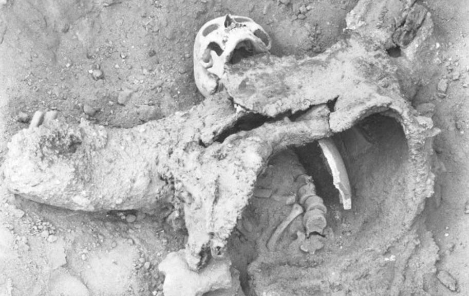
In one of these narrow, low galleries, a pile of bodies, representing about twenty Roman soldiers still with their arms, was found in the 1930s.
While also conducting new fieldwork at the site, James has recently reappraised this coldest of cold-case ‘crime scenes’, in an attempt to understand exactly how these Romans died, and came to be lying where they were found.
Dr James, Reader in the School of Archaeology and Ancient History at the University of Leicester, said: “It is evident that, when mine and countermine met, the Romans lost the ensuing struggle.
Careful analysis of the disposition of the corpses shows they had been stacked at the mouth of the countermine by the Persians, using their victims to create a wall of bodies and shields, keeping Roman counterattack at bay while they set fire to the countermine, collapsing it, allowing the Persians to resume sapping the walls.
This explains why the bodies where they were found. But how did they die? For the Persians to kill twenty men in a space less than 2m high or wide, and about 11m long, required superhuman combat powers-or something more insidious.”
Finds from the Roman tunnel revealed that the Persians used bitumen and sulphur crystals to get it burning. These provided the vital clue. When ignited, such materials give off dense clouds of choking gases, which could prove to be deadly to anyone that comes into contact with it. This is why such dangerous and hazardous chemicals are now stored away in cages like those you can find at Storemasta to help protect the health of the people. Of course, in those days, it is very unlikely that these types of things existed.
“The Persians will have heard the Romans tunnelling,” says James, “and prepared a nasty surprise for them. I think the Sasanians placed braziers and bellows in their gallery, and when the Romans broke through, added the chemicals and pumped choking clouds into the Roman tunnel.
The Roman assault party were unconscious in seconds, dead in minutes. Use of such smoke generators in siege-mines is actually mentioned in classical texts, and it is clear from the archaeological evidence at Dura that the Sasanian Persians were as knowledgeable in siege warfare as the Romans; they surely knew of this grim tactic.”
Ironically, this Persian mine failed to bring the walls down, but it is clear that the Sasanians somehow broke into the city. James recently excavated a ‘machine-gun belt’, a row of catapult bolts, ready to use by the wall of the Roman camp inside the city, representing the last stand of the garrison during the final street fighting.
The defenders and inhabitants were slaughtered or deported to Persia, the city abandoned forever, leaving its gruesome secrets undisturbed until modern archaeological research began to reveal them.
Illustration showing the proposed use of toxic gas at Dura-Europos.
Gates of Biblical City Unearthed- Site of Jesus Miracle of feeding 5,000
In the last few weeks, local officials in northern Golan Heights in Israel announced a significant discovery by archaeologists. The entrance gate to the great fortified city, just north of the Sea of Galilee has been excavated, leading some to claim it is additional evidence supporting the site being Bethsaida, the city of three of Jesus’ disciples and associated with his famous miracle of the loaves and fishes. The early phase of the city may also have an intriguing connexion to the Bible’s King David, who reigned around 1000 BC.
A model of the city gate of Zer under construction. Courtesy of The International Studies and Programs
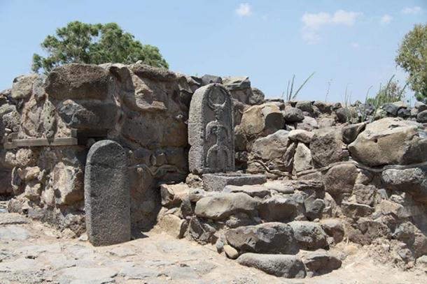
The remains of the entrance gate, standing about 10 feet high, were unearthed at a place called et-Tell by the Bethsaida Excavations Project, which just wrapped up its 2018 season. The director is Professor Rami Arav from the University of Nebraska at Omaha, who has excavated the site for nearly 30 years.
“It is the largest and the best preserved city gate [in Israel],” Arav told the Times of Israel. “Likewise, this year’s excavation provides evidence that Bethsaida, an Aramean settlement, houses one of the earliest towers incorporated in city walls in Israel,” he said.
“In the entire archaeology of the Land of Israel from 10-8th century BCE, there are no towers on city walls. Israelites did not have this feature. This is the first example of towers surrounding a city in Israel,” Arav added. This “unusual feature” of guard towers were placed every 20 meters around the city wall.
The gate is believed by archaeologists to have been used from the 11th century BC down to about 920 BC. As reported in the Jerusalem Post, Professor Arav stated, “There are not many gates in this country from this period. Bethsaida was the name of the city during the Second Temple period [during the time of Jesus], but during the First Temple period it was the city of Zer.” Pointing to Joshua 19:35, he continued, “The fortified towns were Ziddim, Zer, Hammath, Rakkath, Kinnereth.”
These were the fortified cities in land allotted to the tribe of Naphtali after the conquest of Canaan. If this was the site of Zer, there should be even older remains, under the current dig levels, from the period of Israel’s conquest of Canaan.
The inner gate floor from the 11th-10th century BC
The city of Zer (or “Tzer”) was also possibly the historical capital of Geshur, which at the time of King David was an independent Aramean kingdom just northeast of Israel.
The area may have been referenced in the famous Tel Amarna letters between Pharaoh Akhenaten and city leaders in Canaan. The Bible says one of David’s wives was Maacah the daughter of the king of Geshur, apparently a politically-driven marriage to unify the two kingdoms.
The third [son of David], Absalom, whose mother was Maacah, the daughter of Talmai, king of Geshur…
– 1 Chronicles 3:2 (ESV)
The Times of Israel points out that Maacah (or “Maachah”) was the mother of Absalom, who fled to his mother’s homeland of Geshur after murdering his half-brother (2 Samuel 13:37-38). The close ties between the two kingdoms were renewed when Absalom’s daughter, also named Maacah, married Solomon’s son Rehoboam, king of Judah (1 Kings 14:31-15:2). These facts cause Arav to speculate that King David may have walked through this very gate to claim his bride. He amusingly recounted his impression of the royal courtship in the Time articles:
‘King David entered the gate to meet the king of Geshur to ask for the hand of his daughter. Maachah looked at him like a “hillbilly” mountain guy, but for the sake of inclusion into the Bible, went through with it. “So we’re digging the gate where David entered,” said Arav, laughing.’
Judea Capta coin with the head of Domitian found at Bethsaida, dated to AD 85.
In past seasons, evidence from many different periods was found, evidence that this site had significance for millennia. Among the finds was a decorated pottery shard from 300 BC showing the birth of the Greek goddess Athena from the head of her father Zeus. Also found was a rare Roman coin issued in AD 85 by Agrippa II with the phrase “Judea Capta” (or “Judea is captive”), commemorating the crushing of the Jewish rebels and their temple in AD 70.
This year, archaeologists from 20 international institutions joined Arav in the dig sponsored by the Hebrew Union College in Jerusalem. The size of the site confirms the Bible’s account of the significance of Geshur at the time of David.
The Connection to Jesus
The recent finds also join other archaeological evidence in the debate over whether this really was the site of Bethsaida at the time of Jesus. For nearly thirty years, et-Tell has been designated by Israel as Bethsaida, one of the holiest sites to Christians, but for that entire time, this has long been a disputed issue.
Now Philip was from Bethsaida, the city of Andrew and Peter.
– John 1:44 (ESV)
Bethsaida’s importance in the Gospels can be seen in that it is the third most referenced city after Jerusalem and Capernaum. The Book of John mentions that Bethsaida had been home to the apostles Peter, Andrew and Philip. Other passages make it clear that after his marriage, Peter had moved his family into the house of his mother-in-law in nearby Capernaum.
The majority of Jesus’ Galilean ministry took place in the area around Bethsaida, Capernaum and Chorazin – three cities within three miles of each other near the northeast coast of the Sea of Galilee. Because of confusing descriptions in the Gospel accounts, some scholars have proposed that there were two cities named Bethsaida on the shores of Galilee.
An approximate map of Bethsaida near the northern banks of the Sea of Galilee in northern Israel.
The miracle of Jesus feeding 5,000 men plus women and children from five loaves and two fish is said by the Gospel of Luke to have taken place in a wilderness area near the town of Bethsaida.
The miracle of the loaves and fishes – James Tissot between 1886-1894
On their return, the apostles told him all that they had done. And he took them and withdrew apart to a town called Bethsaida. When the crowds learned it, they followed him, and he welcomed them and spoke to them of the kingdom of God and cured those who had need of healing… And taking the five loaves and the two fish, he looked up to heaven and said a blessing over them. Then he broke the loaves and gave them to the disciples to set before the crowd. And they all ate and were satisfied. And what was left over was picked up, twelve baskets of broken pieces.
– Luke 9:10-11, 16-17 (ESV)
This miracle, along with many others done in the area (including the healing of a blind man in Mark 8:22), is the reason behind Jesus’ stern rebuke for the unbelief of the local population in the chapter following the account of the miraculous feeding.
“Woe to you, Chorazin! Woe to you, Bethsaida! For if the mighty works done in you had been done in Tyre and Sidon, they would have repented long ago, sitting in sackcloth and ashes.
– Luke 10:13 (ESV)
The important place these events have in the Gospels draws throngs of Christians to sites in this area every year. Avi Liberman, director of the Jordan Park in which Bethsaida is located, said, “The staff at the Jordan Park and the Golan Tourism are happy for the tens of thousands of visitors who visit the park every day. The wonderful park is also an impressive archaeological site. I [am] amazed each time by the arrival of thousands of evangelical visitors to Bethsaida. I am confident that the latest discoveries will bring more visitors to the park from around the world and from Israel” reported the Jerusalem Post.
4,000 Years old Lost Capital of the Fabled Kingdom, Found in Syria
Ancient city of Urkesh, home to the Hurrian culture.
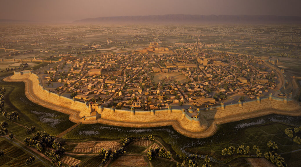
One of the most ancient cities known to exist on earth is Urkesh. Its exact location was a mystery until the 1990s when, after ten years of painstaking excavations, archaeologists identified Tel Mozan in northern Syria near the borders of Turkey and Iran as Urkesh.
The capital city of the Hurrians, it flourished between 4,000 and 1,300 BCE. It initially became powerful because of its location at the intersection of major trade routes as well as its control of valuable copper deposits.
Ruins of monumental public buildings, including a large temple and a palace, have been found. The architecture is not only mud-brick construction but also rare stone structures.
Intact stone stairway at Urkesh.
Archaeologists have discovered remains of an open plaza, a monumental flight of stairs, and a deep underground shaft related to religious rituals known as the “Passage to the Netherworld.”
Urkesh dominated the ancient skyline at the top of a built-up terrace that rivaled nearby mountains.
Lion and stone tablet inscribed with Hurrian language.
Very little was known about the Hurrians before Urkesh was positively identified. There may not have been many Hurrian cities in what is present-day southern Syria, but their civilization influenced the entire Middle East.
They were a major influence on Mesopotamia to the south and cultures such as the Hittites as cities were first developing in that region.
Unlike the centralized political structures of ancient Assyria and Egypt, Hurrian urban culture seems to have been more feudal in the organization, possibly limiting the development of large palace or temple complexes.
The unique Hurrian language is unlike any other known ancient language. Historians believe that the speakers of this language originally came from the Armenian Highlands and spread over southeast Anatolia and northern Mesopotamia at the beginning of the second millennium BCE.
Hurrian incense container.
Accomplished ceramists, Hurrian pottery was highly valued in distant Egypt. Khabur ware and Nuzi ware are two types of wheel-made pottery used by the Hurrians.
Khabur ware is characterized by reddish painted lines with a geometric triangular pattern and dots, while Nuzi ware has very distinctive forms, and are painted in brown or black.
Also known for achievements in metallurgy, Hurrians traded copper south to Mesopotamia from the highlands of Anatolia.
The Khabur Valley had a central position in the metal trade, and copper, silver and even tin were accessible from Hurrian-dominated countries in the Anatolian highland. Among the few surviving examples of Hurrian metalwork, some small fine bronze lion figurines were discovered at Urkesh.
Sadly, the Syrian civil war has disrupted the fascinating archaeological activities at Urkesh and endangered future discoveries about the Hurrian culture. The site lies close to the Turkish border and is now protected by Kurdish troops and a team of local workers.
4,000 year-old bakery with paved floor and “beehive” oven.
The Qasr Al-Farid, The Lonely Castle Of The Nabataeans
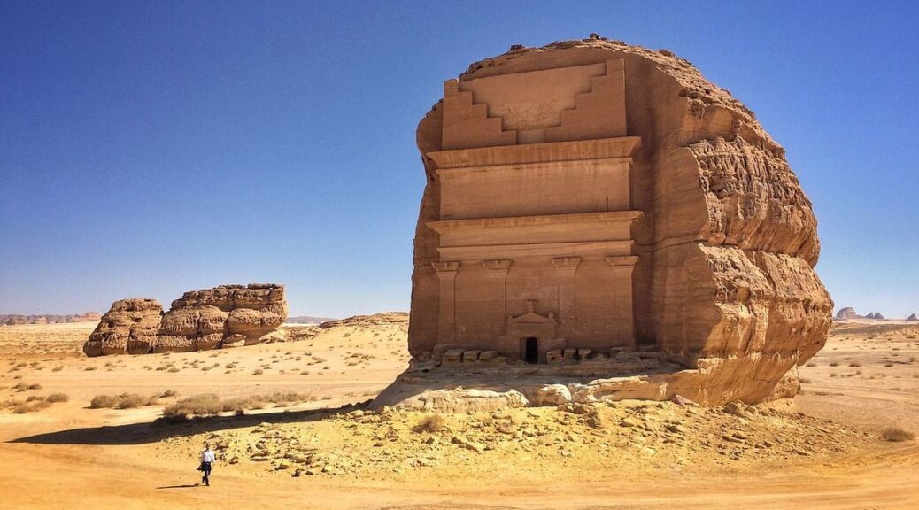
Among the Dozens of ruins located in the archaeological playground of Mada’in Saleh, one literally stands alone. Carved into a massive boulder, Qasr al-Farid, or “The Lonely Castle,” is a stunning ancient structure that rivals the majesty of any carved architecture in the world.
Created around the 1st century CE, the tall facade was never actually finished. The Nabateans had a unique construction technique that saw their tombs being chiselled right out of the rock from the top down.
Such is the case with Qasr al-Farid, although the monument appears to never have been completed, so the craftsmanship and precision of work slowly deteriorate closer to the base of the structure.
The Nabataeans were skilled craftsmen who carved their monuments out of solid roc
One of the most famous monuments of the Madain Saleh archaeological site, listed as a UNESCO World Heritage Site.
Called the “lonely castle”, Qasr Al-Farid is nevertheless a tomb. It was carved out of a rock that appeared out of nowhere about 2,000 years ago.
A construction left in suspense, suggested by the contrast between a facade meticulously carved with columns and crowns, and the other part of the rock still intact.
There seems to be no evidence of burial inside. With its unfinished taste and unusual location, the tomb of Qasr Al-Farid cultivates its mystery.
A tune from Petra to Madain Saleh
Between Qasr Al-Farid and the city of Petra, the resemblance is striking. And for good reason, both sites are from the Nabataean civilization.
The same meticulous work on the rock can be seen, although the Saudi tomb was carved from a block of stone stranded in the desert and not from a gigantic cliff.
The location of the Qasr Al-Farid tomb may suggest that it is completely independent. However, it is part of the vast archaeological site of Madain Saleh. Long unknown, the latter was only explored at the beginning of the 20th century, when a Franco-Saudi mission was commissioned to carry out excavation work.
Over 500 hectares, more than 100 tombs – remains of the Nabataean city of Hegra – have been discovered. In 2008, the site was declared a UNESCO World Heritage Site. A must if you are going to Saudi Arabia!
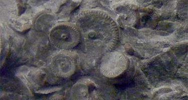
300 Million-Year-Old Machinery Found In Russia, Experts Say Aluminum Gear Not The Result Of Natural Forces, May Be Extraterrestrial
The Voice of Russia and other Russian sources are reporting that a 300 million-year-old piece of aluminum machinery has been found in Vladivostok. Experts say a gear rail appears to be manufactured and not the result of natural forces.
According to Yulia Zamanskaya, when a resident of Vladivostok was lighting the fire during a cold winter evening, he found a rail-shaped metal detail which was pressed in one of the pieces of coal that the man used to heat his home. Mesmerized by his discovery, the responsible citizen decided to seek help from the scientists of the Primorye region. After the metal object was studied by the leading experts the man was shocked to learn about the assumed age of his discovery.
The metal detail was supposedly 300 million years old and yet the scientists suggest that it was not created by nature but was rather manufactured by someone. The question of who might have made an aluminum gear in the dawn of time remains unanswered.
The find was very much like a toothed metal rail, created artificially. It was like parts are often used in microscopes, various technical and electronic devices say writer Natalia Ostrowski at KP UA Daily.
Nowadays, finding a strange artifact in coal is a relatively frequent occurrence. The first discovery of this sort was made in 1851 when the workers in one of the Massachusetts mines extracted a zinc silver-incrusted vase from a block of unmined coal which dated all the way back to the Cambrian era which was approximately 500 million years ago.
Sixty one years later, American scientists from Oklahoma discovered an iron pot which was pressed into a piece of coal aged 312 million years old. Then, in 1974, an aluminum assembly part of unknown origin was found in a sandstone quarry in Romania.
Reminiscent of a hammer or a support leg of a spacecraft “Apollo”, the piece dated back to the Jurassic era and could not have been manufactured by a human. All of these discoveries not only puzzled the experts but also undermined the most fundamental doctrines of modern science.
The metal detail which was recently found by Vladivostok resident is yet another discovery which perplexed the scientists. The coal in which the metal object was pressed was delivered to Primorye from Chernogorodskiy mines of Khakasia region. Knowing that the coal deposits of this region date 300 million years back, Russian experts inferred that the metal detail found in these deposits must be an age-mate of the coal.
Another question that interests Russian scientists is whether the aluminum alloy is of Earthly origin. It is known from the study of meteorites that there exists extra-terrestrial aluminum-26 which subsequently breaks down to magnesium-26. The presence of 2 percent of magnesium in the alloy might well point to the alien origin of the aluminum detail. It could also be evidence of some past, unknown civilization on Earth. Nonetheless, further testing is needed to confirm this hypothesis.
It is the first such finding in coal made in Russia, according to anomaly researcher and biologist Valery Brier, who took microscopic samples of the aluminum for testing. Valery Brier performed X-ray diffraction analysis of the metal. It showed very pure aluminum with microimpurities of magnesium of only 2 – 4 percent.
The find is very much like a toothed metal rail, created artificially. It was like parts that are often used in microscopes, as well as various technical and electronic devices.
While exploring core samples (rock samples) that were raised from a 9-meter depth during the drilling of the seabed to support the bridge on a Russian island near Cape Nazimova, strange metal alloys were discovered that were “preserved” in the prehistoric sandstone (age – 240 million years old).
The pieces of special alloys had an unusual composition and were clearly not used in the drilling machinery. The alloys, said Brier, were artificial and constructed by intelligent beings.
Reconstruction of the item found near Cape Nazimova
Not so long ago in Russia a mechanical device was found in volcanic rock which was dated 400 million years before the current era (B.C.E)
It was found on the remote Kamchatka Peninsula, 150 miles from the village of Tigil, by archaeologists at the University of St. Petersburg among found strange fossils. The reliability of the finds has been certified. According to archaeologist Yuri Golubev the find amazed experts as it was some sort of a machine.
The most ancient vase on Earth was discovered in 1851 in Massachusetts when blasting in the quarry. It is a silver-zinc vase inlaid with fine silver in the form of the vine. The age of this vase, according to the rock in which it was found, is 534 million years old
Another strange artefact that was found in coal is the iron pot shown below. It was found in 1912 in Oklahoma in a piece of coal with an estimated age of 312 million years.
In Romania in 1974, in a sandstone quarry of not less than 1 million years old was found aluminum parts, reminiscent of a hammer or a support leg landing spacecraft “Viking” and “Apollo”.
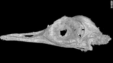
Smallest Dinosaur ever Found Preserved in 99- million-year-old Piece of Amber
The head of a flying dinosaur that is hardly bigger than a bee hummingbird has been discovered in 99-million-year-old amber. The piece of polished amber, just 31mm by 20mm by 8.5mm, was found in Kachin Province of northern Myanmar, an area becoming increasingly well-known for its remarkable amber-encased fossils.
The piece of amber measures only 1.25 inches (31.5 millimeters) in length. The skull is a mere 0.6 inches (11 millimeters).
The amber contains the skull of Oculudentavis khaungraae, a newly described dinosaur and one of the smallest ever discovered. Its tiny stature is forcing paleontologists to rethink the lower limits of body size in birds, and the nearly 100-million-year-old fossil is challenging the current understanding of when and how dinosaur giants shrank into the birds of today.
A Mysterious Transformation
Tiny Oculudentavis may have occupied a unique ecological niche in the ancient world.
The evolutionary transition of dinosaurs to modern birds is one of the most astounding transformations in the history of life: large, bipedal and mostly carnivorous dinosaurs morphed into small, flying birds. Famous discoveries like Archaeopteryx and more recently the fossils from the Jehol Biota in China have given researchers some hints about the process. But finds from this evolutionary phase — which researchers think began about 200 million years ago — are rare.
Paleontologists are far from having a complete picture of the evolution of birds, and even farther from a full inventory of Earth’s ecosystems in the age of dinosaurs. Our research on the tiny Oculudentavis, published in the journal Nature, adds valuable information to the puzzle of when, how, and to what extent dinosaurs shrank.
Clues in Bone
This high-resolution scan allowed us to see the intricacies of a bone structure unlike any before seen in birds or dinosaurs.
This high-resolution scan allowed us to see the intricacies of a bone structure unlike any before seen in birds or dinosaurs.
Our team needed to see the minute details of the skull, and we needed to do it without cracking or ruining the specimen – a difficult task with a skull encased in 99-million-year old amber from Myanmar. To do that, we scanned the skull with high-resolution X-rays and created a digital model with very fine anatomical detail. What emerged was a picture of overall bird-like anatomy. But in some interesting ways, Oculudentavis is unlike any bird or dinosaur that has ever been found.
The obvious curiosity of the fossil is its size: Oculudentavis rivaled the smallest bird living today, the bee hummingbird, and likely was no more than 1.6 inches (4 centimeters) from beak to tail. We considered whether the skull possibly belonged to a very young animal, but the extent and pattern of bone growth and the proportional size of the eye pointed to a mature bird.
With a total skull length of just about 0.6 inches (1.5 centimeters), Oculudentavis pushes against what is considered the lower limit of size in birds: the head still had to hold functional eyes, a brain, and jaws. The small size is especially surprising if one considers that Oculudentavis lived during the same time as giant plant-eating dinosaurs like Argentinosaurus.
Small and Specialized
The small size of Oculudentavis is striking, but to a trained eye, there are other extremely unusual features, too.
First of all, the skull seems to be built for strength. The bones show an unusual pattern of fusion and the skull lacks an antorbital fenestra, a small hole often found in front of the eye.
The eyes of Oculudentavis also surprised us. The shape of the bones found within the eye, the scleral ossicles, suggests that it probably had conical eyes with small pupils. This type of eye structure is especially well adapted for moving around in bright light. While daytime activity might be expected for an ancient bird from the age of dinosaurs, the shape of the ossicles is entirely distinct from any other dinosaur and resembles those of modern-day lizards.
Adding to the list of unexpected features, the upper jaw carries at least 23 small teeth. These teeth extend all the way back beneath the eye and are not set in deep pockets, an unusual arrangement for most ancient birds. The large number of teeth and their sharp cutting edges suggest that Oculudentavis was a predator that may have fed on small bugs.
The sum of these traits — a strong skull, good eyesight, and a hunter’s set of teeth — suggests to us that Oculudentavis led a life previously unknown among ancient birds: it was a hummingbird-sized daytime predator.
One of the Earliest and Tiniest Birds?
Placing Oculudentavis in the tree of life is, given its strange anatomy, challenging. Our phylogenetic analysis — the investigation of its relationships to other dinosaurs — identifies Oculudentavis as one of the most ancient birds. Only Archaeopteryx branched off earlier.
Scientists consider the nectar-feeding hummingbirds — which appeared 30 million years ago — the smallest dinosaurs on record. But if our placement of Oculudentavis holds true, the miniaturization of dinosaurs may have peaked far earlier than paleontologists previously thought. In fact, the largest and the smallest dinosaurs may have walked and flown the same earth nearly 100 million years ago.
Our work demonstrates how little scientists know about the little things in the history of life. Scientists’ snapshot of fossil ecosystems in the dinosaur age is incomplete and leaves so many questions unanswered. But paleontologists are eager to take on these questions.
What other tiny species were out there? What was their ecological function? Was Oculudentavis the only visually guided bug hunter? To better understand the evolution of the diversity of life we need more emphasis and recognition of the small.
Amber holds strong potential to fill that gap. Maybe one day a scientist will hold up another piece, and let sunshine reveal a complete Oculudentavis, or even a previously unknown species. More finds in amber will help illuminate the world of the tiny vertebrates in the age of dinosaurs.
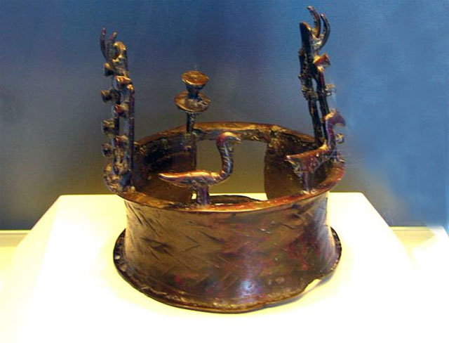
The oldest crown in the world, which is considered to be more than 6000 years old, has been shown for the first time in America. The ancient relic, which dates back to the Copper Age between 4000–3300 B.C., is shaped like a thick ring and features vultures and doors protruding from the top.
It is assumed that the crown engaged in funeral ceremonies of important people at the time. The crown was found in a remote cave in the Judaean Desert near the Dead Sea in 1961 among hundreds of other objects from the period.
Known as the ‘Nahal Mishar Hoard’, more than 400 objects were discovered by Pessah Bar-Adon and his fellow Israeli archaeologists in the cave which became known as the ‘Cave of the Treasure’.
The world’s oldest crown: This headpiece dating back to the Copper Age between 4000-3300 B.C. was found in a remote cave in the Judaean Desert in Israel in 1961.
The pieces included two clay statues of Gods – The Lady and Ram of Gilat – and a full array of Copper Age figurines made from copper, stone, elephant ivory and clay.
There was also a scepter decorated with horned animals, clay goblets and bowls. It has been suggested that the hoard was the sacred treasure belonging to a shrine at Ein Gedi, some twelve kilometers away.
The purpose of the hoard remains a mystery, it may have been to keep them protected in an emergency, although it is believed the objects may have been used in public ceremonies.
Around 150 artefacts from the collection can be seen at New York University’s Institute for the Study of the Ancient World as part of the ‘Masters of Fire:
Huge hoard: Archaeologists discovered more than 400 items hidden within the cave
Other discoveries: Among the other items discovered in the cave was a libation vessel in the shape of a woman carrying a churn, pictured left, and a fenestrated stand with three bowls and sculpted motifs, pictured right
Daniel M. Master, Professor of Archaeology at Wheaton College and a member of the curatorial team, said: ‘The fascinating thing about this period is that a burst of innovation defined the technologies of the ancient world for thousands of years.
‘People experimented with new ways to use not just copper, but also leather, ceramics, and textiles – sometimes successfully, sometimes not.’
Jennifer Y. Chi, ISAW Exhibitions Director and Chief Curator, added: ‘To the modern eye, it’s stunning to see how these groups of people, already mastering so many new social systems and technologies, still had the ability to create objects of enduring artistic interest.’
The exhibit also features objects from the Peqi’in Cave, another important discovery site.
The most significant finds included are eight ossuaries, or burial containers, for human skeletal remains. Some were designed to look like human faces or figures and all are decorated with red stripes or zigzag patterns.
These ossuaries held the bones of more than one person – the vast majority were men. Those who had their bones stored would have held positions of importance within society.
For use in funerals: An ossuary with painted and sculpted facial features, pictured left, and a painted anthropomorphic ossuary with sculpted nose, stamped eyes, and gaping mouth, pictured right
Unusual: A libation vessel in the shape of a Ram carrying cornets
Never before seen strange 5,000-year-old clay figurine with a tattooed face and bone mask
In Russia, a macabre was found it is a 5000-year-old mass grave containing the bodies of five decapitated individuals. Archaeologists suspect the ancient Odinov culture in Siberia were head cultists.
Professor Vyacheslav Molodin said that the graveyard of Ust-Tartas 2 in the city of Novosibirsk comprises three decapitated adults and two teenagers. It is assumed that their heads were cut after death – and then kept for worship.
‘Odinov people definitely had a head or skull cult,’ said the archaeologist.
‘It is a characteristic feature of this culture that they had graves with cut off heads. They were perhaps put into a sanctuary, or buried separately in a different way.’
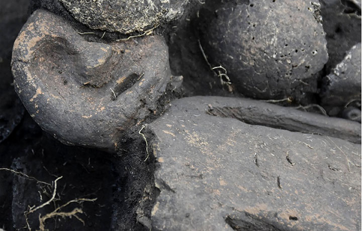
In another grave on the same site, an astonishing figurine has been found on the shoulder of an ancient woman who was laid to rest with her head on a man’s abdomen.
The skeletons of the ancient presumed lovers were cocooned together under a birch bark blanket for five millennia, but in this case, their heads were not severed.
The man lay on his back, she on her front, facing him in a timeless embrace. Perched on the female’s shoulder was a palm-sized clay figurine with a tattooed face.
Bronze Age statuette with a tattooed face was found on the shoulder of the buried ancient woman. It features a deep recess down its centre
Dr Molodin called the Bronze Age figurine discovery the ‘most astonishing find’ of the summer archaeological season this year
‘Interestingly, our anthropologists and genetics found that the Odino people were Mongoloids, yet the face of the figurine had clear Caucasian features. We don’t see the gender of the figurine, which is unusual, and we can’t say if it was dressed’, said Vyacheslav Molodin. Pictures: Novosibirsk Institute of Archeology and Ethnography
It has a mask made of bone – horse vertebrae – decorated with what appears to be an image of a bear’s muzzle, say scientists. Inside the grave, it had been placed on its front and had its head broken off.
It was then turned upside down so that it ‘looked up’ towards its owner in a bizarre ritual – something ‘yet unseen’ by Novosibirsk archaeologists.
One side of the middle of the statuette also has a long narrow hole, which had a bronze plate and also some organic substance inside it. Chemical tests are needed to establish more about what was placed inside that opening.
Dr Molodin said the discovery was unique.
‘We’ve never come across anything like this, despite our extensive knowledge of the Odinov culture’s burial rites,’ he said to the Siberian Times.
‘The woman must have been an unusual person to have such a figurine “escorting” her to the afterlife.’
Dr Molodin, a member of the Russian Academy of Sciences (RAS), called the Bronze Age figurine discovery the ‘most astonishing find’ of the summer archaeological season.
While the Odinov cattle-breeding people were Mongoloids, the face of the figurine ‘has obviously Caucasian features’ with ‘big eyes and a snub nose’, he said.
This was a tiered grave that had two more people buried beneath the loving couple that were facing each other.
It’s possible the palm-sized figurine was hoped to escort the ‘unusual’ woman to the afterlife. It had its head broken off so it ‘looked up’ at its owner in a bizarre ritual