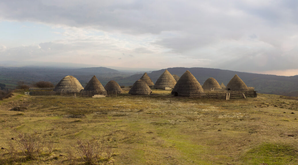
Village in Canada: 8,000 years‘older than Egyptian pyramids’
Archaeologists on British Columbia’s Triquet Island have excavated an ancient settlement dating back some 14,000 years, to the last ice age.
Archaeologists working with the support of the Hakai Institute began excavations on Triquet Island last summer.
Since then, they have uncovered a number of artifacts linked to an ancient human settlement on the island, including fish hooks, a hand drill used to ignite fires, and a wooden device used to launch projectiles, called an atlatl.
Buried some 2.5 meters underground, beneath layers of soil and peat, they discovered something even more intriguing.
From the charred remains of an ancient hearth, the scientists used tweezers to painstakingly extract a few tiny flakes of charcoal.
In November, carbon dating of the flakes revealed the hearth was some 14,000 years old—thousands of years older than ancient Rome or the Egyptian pyramids. In fact, the Triquet Island village dates back to the period of the last ice age, making it one of the oldest settlements ever discovered in North America.
Alisha Gauvreau displays one of the artifacts from the site.
Researchers from the Hakai Institute and the University of Victoria, with local First Nations members, unearthed revealing artifacts on Triquet Island, around 310 miles northwest of Victoria, Canada. They’ve found fish hooks, spears, and tools to ignite fires. Thanks to the discovery of the ancient village last year, researchers now think a massive human migration may have happened along British Columbia’s coastline.
The newly discovered settlement is about as old as the spear tip found in a mastodon skeleton on Washington’s Olympic Peninsula in 1977. That notable discovery pushed back estimates of the earliest human occupation on the western coast of North America to around 13,800 years ago (about 800 years earlier than previously thought).
Discovery of the settlement may well impact our understanding of ancient human migration patterns, as it challenges the traditional story of how the first humans arrived in the Americas.
That theory argues that the earliest arrivals came to the region by crossing a land bridge connecting modern-day Siberia to Alaska some 13,000 years ago.
But according to more recent research, the land bridge route may not have offered enough resources to support the earliest migrants during their crossing. Instead, humans may have traveled via boat, and entered North America along the coast.
The find fits right in with the oral history of a First Nations government in British Columbia, the Heiltsuk Nation.
Alisha Gavreau, a Ph.D. student at the University of Virginia and a researcher with the Hakai Institute, told the CBC that the Triquet Island settlement “really adds additional evidence” to the coastal entrance theory. “Archaeologists had long thought that…the coast would have been completely uninhabitable and impassible when that is very clearly not the case,” she notes.
Evidence from the site also shows the people who settled there were “rather adept sea mammal hunters.”
Gavreau presented her team’s findings at the annual meeting of the Society for American Archaeology. Some 3,000 scientists from around the world attended the five-day conference, held in Vancouver.
In addition to its impact on current thinking regarding human migration to North America, the discovery of the settlement is a key development for the Heiltsuk Nation.
“This find is very important because it reaffirms a lot of the history that our people have been talking about for thousands of years,” said William Housty, a member of Heiltsuk Nation.
Such an affirmation will likely help the community going forward, as it negotiates with the Canadian government about territorial rights.
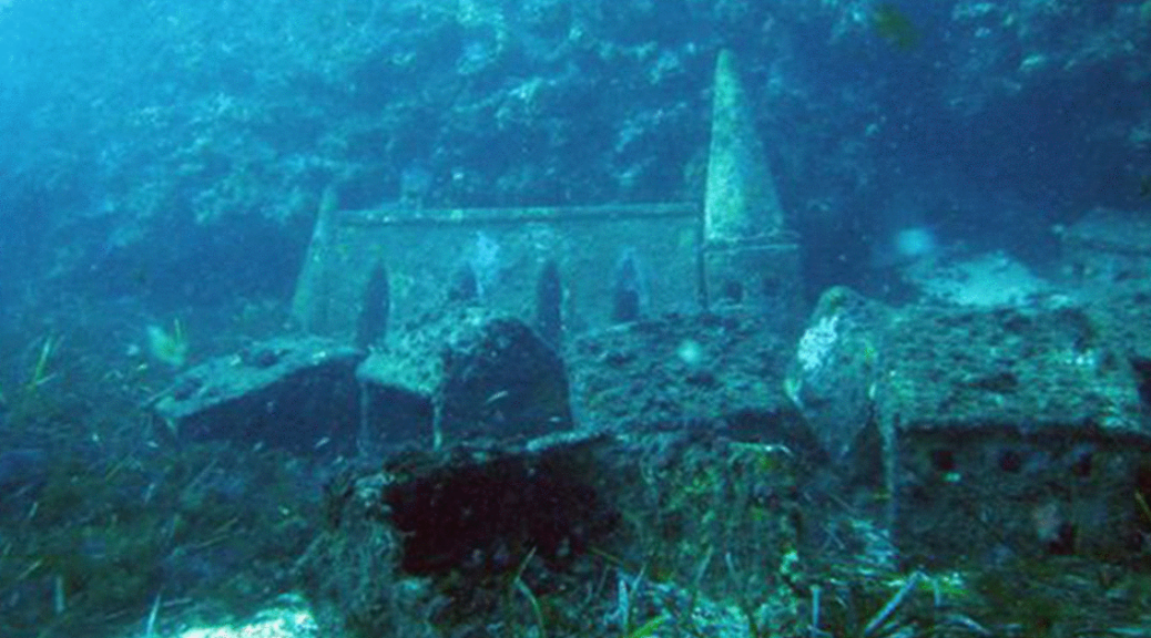
The Prairies are home to tons of hidden treasures, some of which are hiding right under our noses. Even though this lake is super popular and is located in a huge national park, few could ever guess a ghost town lies just beneath the waters.
The sunken city under Lake Minnewanka is a hidden treasure that few have seen and it’s waiting to be discovered.
Deep below the surface of the lake’s pristine waters is the sunken resort town of Minnewanka Landing. While it used to bustle with tourism and life, according to Parks Canada, its only residents are now trout and the occasional scuba diver.
Beneath the surface of Lake Minnewanka, located in Alberta, Canada, rests the remains of a former resort town.
The village was built way back in 1888 when the water levels were much lower. Soon, cottages sprung up, restaurants and hotels were built, and even a boat tour started ferrying travellers around the scenic lake. For a little while, life was great at Minnewanka Landing.
Over the years the town grew to include four avenues, three streets, dozens of cottages, numerous hotels and restaurants, and multiple sailing outfits that would take guests on boat excursions around the (much smaller) original lake.
It wouldn’t be until 1912 that the area’s landscape would start to evolve with the construction of a new dam—part of a Calgary Power Co. hydroelectric plant operation being set up downriver—resulting in the flooding of a good portion of Minnewanka Landing.
But while the town continued to thrive over the next two decades (42 lots were built to make way for additional cabin sites), it would finally meet its fate in 1941 with the building of a new dam, which raised the reservoir’s waters by 98 feet, engulfing everything in its wake.
“It was during the Second World War and everyone was hungry for power,” Bill Perry, an archeologist with Parks Canada, tells Smithsonian.com. “Calgary and the surrounding area were growing substantially during that point in time and required more power, so Lake Minnewanka was seen as an easy end.”
Today the reservoir hides a secret that many people will never get the chance to experience—unless they’re scuba divers, that is. Thanks to Lake Minnewanka’s glacier-fed, ice-cold waters, many structures of the former resort town still remain intact, including house and hotel foundations, wharves, an oven, a chimney, a cellar, bridge pilings, and sidewalks. (A full list of sites is available here.) Even the footings from the town’s original dam, built by the federal government in 1895, along with the footings from the dam built in 1912, remain visible.
Another notable site nearby is a native campsite that dates back thousands of years.
In recent years, archaeologists have uncovered spear points, arrowheads, ancient weapons known as atlatls, stone tools, and other implements used by indigenous tribes who once lived there.
“What is particularly interesting about that for me is looking at the whole area as a cultural landscape,” Perry says. “The area’s 13,000 years of continuous use absolutely fascinates me.”
And Perry isn’t alone. He estimates that approximately 8,000 divers descend into the lake each year to explore its hidden past.
“Because of the cold, clear water, wood actually survives quite well down there,” he says. “That’s why it has become such a popular diving place for local scuba diving clubs. There’s just so much left to see.”
3,800-year-old Underwater Potato Garden Uncovered in Canada
Hundreds of blackened potatoes were pulled out of the ground at a prehistoric garden in British Columbia, Canada. Dating back to 3,800 years before the present, the garden was once under water, in an ecologically rich wetland.
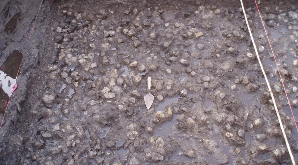
Submerged rock pavement (shown here) would have allowed the indigenous people to control how far their tubers grew, making for easier harvesting.
And it shows sign of sophisticated engineering techniques used to control the flow of water to more efficiently grow wild wapato tubers, also known as Indian potatoes.
Archaeologists led by Tanja Hoffmann of the Katzie Development Limited Partnership and Simon Fraser University in British Columbia excavated the garden during roadwork on Katzie First Nation territory just east of Vancouver, near the Fraser River.
The site had been waterlogged for centuries, resulting in good preservation of plant and other organic materials like wooden tools that would have normally disintegrated over time.
In all, the researcher counted 3,767 whole and fragmented wapato plants (Sagittaria latifolia). Today, these plant are found in wetlands across southern Canada and the United State.
The ancient garden was found during roadwork on Katzie First Nation territory just east of Vancouver, near the Fraser River.
Though they were not domesticated, the chestnut-sized roots had long been important to indigenous peoples, and they are mentioned in some of the 1st ethnographic accounts of the Pacific Northwest.
Explorer Meriwether Lewis and William Clark, for example, were offered wapato roots at a native village near present day Portland, Oregon.
Clark wrote in his diary that the plant resembled a “small Irish potato,” and after being roasted, had “an agreeable taste and answers very well in place of bread.”
The ancient tubers that were discovered in British Columbia had turned dark brown to black in color, and some still had their starchy insides preserved.
Ancient wapato tubers from the underwater garden site.
The garden had been covered in tightly packed, uniformly sized rock, leading the researchers to conclude that this was a man made deposit.
Wapato plants can grow far underground, but an artificial rock “pavement” would have controlled how deep the roots could penetrate.
This would have allowed the harvesters to more easily find the tubers and pull them out of the muck, Hoffmann and her colleagues wrote in their study.
Besides this waterlogged garden, the archaeological sites also had a dry area where people would have lived. The researcher also found about 150 wooden tools that would have been used to dig out the plants.
Radiocarbon dates from the burnt wood found at the site suggest it dates back to 3,800 years ago and was abandoned 3,200 years ago.
The site could represent the 1st direct evidence of wetland plant cultivation in the prehistoric Pacific Northwest, according to the report on this discovery.
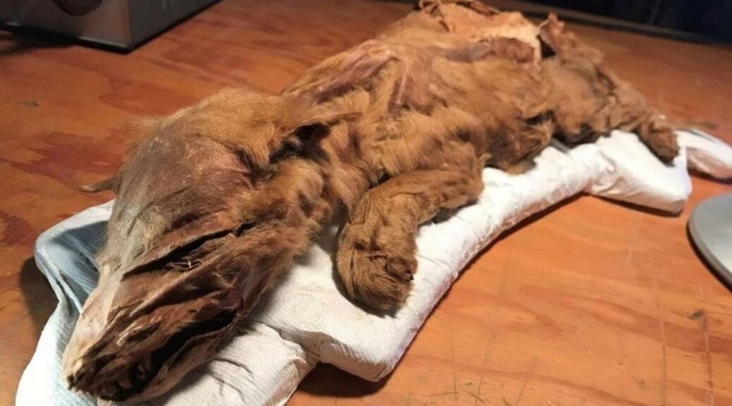
Miners Unearth 50,000-Year-Old Caribou Calf, Wolf Pup From Canadian Permafrost
A mummified wolf pup and caribou believed to have walked Earth over 50,000 years ago were discovered with tissue and fur intact — a remarkable find, Canadian authorities say.
The caribou was found at the site of an 80,000-year-old volcanic ash bed and officials believe it’s among the oldest mummified mammal tissue in the world, according to a release.
It was discovered by gold miners, the wolf pub was remarkably well-preserved remains of a caribou calf and wolf pup that each lived more than 50,000 years ago.
The Ice Age specimens were found in the Tr’ondëk Hwëch’in Traditional Territory, a First Nation territory in Yukon.
Officials say the ancient caribou dug up from a site containing an 80,000-year-old volcanic ash bed now stands as one of the oldest examples of mummified mammal tissue in the world.
Gold miners in Canada have discovered the remarkably well-preserved remains of a caribou calf and wolf pup (shown) that each lived more than 50,000 years ago. The wolf pup’s remains were complete, with its head, tail, paws, skin, and hair
After miners first discovered the mummified animals in the Klondike region, researchers with the Yukon Paleontology Program recovered and conducted analyses of the remains.
With each still containing hair, skin, and muscle tissue, the experts say the discoveries are extremely rare.
The 50,000-year-old caribou and wolf pup could help to ‘shed light on Yukon’s fascinating Ice Age history and will help us understand how these long-gone creatures lived in the environment they inhabited,’ said Premier Sandy Silver.
Both of the mummies were discovered back in 2016.
The caribou calf was found on Tony Beets’ placer gold mine on Paradise Hill June 3 of that year. Beets are best known from Discovery’s show, Gold Rush.
The mummified wolf pup was found the following month.
Officials say the ancient caribou dug up from a site containing an 80,000-year-old volcanic ash bed now stands as one of the oldest examples of mummified mammal tissue in the world. Only the front half of its body remained intact
While the caribou carcass is missing some parts of its body, with only the front half still intact, the wolf pup was found to be complete, with its head, tail, paws, skin, and hair.
‘We found the caribou and our neighbours, the Favron’s found the wolf pup,’ Beets wrote on Facebook.
‘Such amazing things to be found here under the midnight sun.’
The discoveries hold special significance to the Tr’ondëk Hwëch’in, upon whose land they were discovered. Both animals will be on display for the rest of the month, before being moved to the Yukon Beringia Interpretive Centre in Whitehorse. The mummified wolf is shown
The two Ice Age specimens were unveiled at the Dänojà Zho Cultural Centre last week.
And, they hold special significance to the Tr’ondëk Hwëch’in, upon whose land they were discovered.
‘For Tr’ondëk Hwëch’in, wolf and caribou are very important and interconnected,’ said Tr’ondëk Hwëch’in Chief Roberta Joseph.
‘The caribou has fed and clothed our people for thousands of years. The wolf maintains balance within the natural world, keeping the caribou healthy.’
Both mummified animals will be on display for the rest of the month, before being incorporated into an exhibit at the Yukon Beringia Interpretive Centre in Whitehorse.
‘These specimens will help scientists learn more about the ancient mammal species that roamed Beringia, increasing our knowledge and ability to share the stories of this lost, ancient land,’ said Minister of Tourism and Culture Jeanie Dendys.
The caribou calf (shown) was found on Tony Beets’ placer gold mine on Paradise Hill (right) June 3 2016. Beets is best known from Discovery’s show, Gold Rush
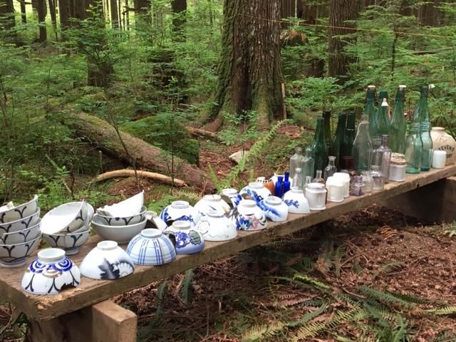
A Lost Japanese Village Has Been Uncovered in the British Columbia Wilderness
In 2004, archaeology professor Robert Muckle was alerted to a site within the forests of British Columbia’s North Shore mountains, where a few old cans and a sawblade had been discovered. He suspected the area was once home to a historic logging camp, but he did not anticipate that he would spend the next 14 years unearthing sign after sign of a forgotten Japanese settlement—one that appears to have been abruptly abandoned.
Brent Richter of the North Shore News reports that Muckle, an instructor at Capilano University in Vancouver, and his rotating teams of archaeology students have since excavated more than 1,000 items from the site.
The artifacts include rice bowls, sake bottles, teapots, pocket watches, buttons, and hundreds of fragments of Japanese ceramics. Muckle tells Smithsonian that the “locations of 14 small houses … a garden, a wood-lined water reservoir, and what may have been a shrine,” were also discovered, along with the remnants of a bathhouse—an important fixture of Japanese culture.
Dishes and bottles found at the site in the Lower Seymour Conservation Reserve.
The settlement sits within an area now known as the Lower Seymour Conservation Reserve, located around 12 miles northeast of Vancouver.
Muckle has in fact uncovered two other sites within the region that can be linked to Japanese inhabitants: one appears to have been part of a “multi-ethnic” logging camp, Muckle says, the second a distinctly Japanese logging camp that was occupied for several years around 1920. But it is the third site, which seems to have transitioned from a logging camp to a thriving village, that fascinates him the most.
“There was very likely a small community of Japanese who were living here on the margins of an urban area,” Muckle tells Richter. “I think they were living here kind of in secret.”
In approximately 1918, a Japanese businessman named Eikichi Kagetsu secured logging rights to a patch of land next to where the village once stood, making it likely that the site was once inhabited by a logging community.
The trees would have been largely harvested by around 1924, but Muckle thinks the village’s residents continued to live there past that date.
“The impression that I get, generally speaking, is it would have been a nice life for these people, especially in the context of all the racism in Vancouver in the 1920s and ’30s,” he tells Richter.
The first major wave of Japanese immigration to Canada began in 1877, with many of the new arrivals settling in the coastal province of British Columbia. From the start, they were met with hostility and discrimination; politicians in the province prohibited Asian residents from voting, entering the civil service, and working in various other professions, like law, according to the Canadian Encyclopedia.
Anti-Japanese prejudices boiled over during the Second World War, in the wake of the attack on Pearl Harbor in December 1941. Days later, Japanese troops invaded Hong Kong, killing and wounding hundreds of Canadian soldiers who were stationed there.
Back in Canada, authorities began arresting suspected Japanese operatives, impounding Japanese-owned fishing boats, and shutting down Japanese newspapers and schools. By the winter of 1942, a 100-mile strip of the Pacific Coast had been designated a “protected area,” and people of Japanese descent were told to pack a single suitcase and leave.
Families were separated—men sent to work on road gangs, women, and children to isolated ghost towns in the wilderness of British Columbia. According to the Canadian Encyclopedia, more than 90 percent of Japanese Canadians were uprooted during the war, most of the citizens by birth.
No records survive of the people who lived in the North Shore camp, and Muckle has yet to find an artifact that can be reliably dated to after 1920. But given that the inhabitants of the village seem to have departed in a hurry, leaving precious belongings behind, he tells Smithsonian that he suspects they stayed in their little enclave in the woods until 1942, when “they were incarcerated or sent to road camps.”
Eventually, per the CBC, the Greater Vancouver Water District closed off the valley where the settlement was located, and the forest began to take over.
Speaking to Richter of North Shore News, Muckle notes that, after nearly 15 years spent excavating at the site, he will likely not return again.
But he hopes to share his records and artifacts with several museums and archives— including the Nikkei National Museum & Cultural Centre in Burnaby, British Columbia, which seeks to preserve Japanese Canadian history and heritage—so the forgotten settlement in the woods will be remembered for years to come.
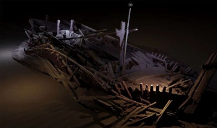
Archaeology breakthrough: Astounding discovery of Arctic shipwreck ‘frozen in time’
Although found in the far north of Canada in 2016 off King William Island, the wreck was not thoroughly studied until 2019.
Experts said that the vessel one of Sir John Franklin’s long lost 1845 expeditions to the Northwest Passage, was remarkably well preserved.
The lead archeologist on the project Ryan Harris, said last year, “The ship is amazingly intact. “We were able to explore 20 cabins and compartments, going from room to room. The doors were all eerily wide open.”
The ship belonged to Sir John Franklin
The Parks Canada and Inuit team participated in a number of dives, using drones to study the openings in the main hatchway and skylights in the crew’s cabins, officers’ mess, and captain’s stateroom.
Mr. Harris continued: “We were able to explore 20 cabins and compartments, going from room to room.”
What they saw astonished them: dinner plates and glasses still on shelves, beds, and desks in order, scientific instruments in their cases and hints that journals, charts, and perhaps even early photographs may be preserved under drifts of sediment that cover much of the interior, National Geographic reported.
Archaeology news: Plates and other items were found
Mr. Harris said: “Those blankets of sediment, together with the cold water and darkness, create a near-perfect anaerobic environment that’s ideal for preserving delicate organics such as textiles or paper.
“There is a very high probability of finding clothing or documents, some of them possibly even still legible. Rolled or folded charts in the captain’s map cupboard, for example, could well have survived.”
The only area below deck the team was unable to access was the captain’s sleeping quarters.
However, the expedition helped researchers find some clues to build a timeline for the disaster.
He continued: “We noticed the ship’s propeller still in place. We know that it had a mechanism to lift it out of the water during winter so that it wouldn’t be damaged by the ice.
“So, the fact that it’s deployed suggests it was probably spring or summer when the ship sank. So, too, does the fact that none of the skylights were boarded up, as they would have been to protect them against the winter snows.”
“No doubt there are a lot more answers lying beneath the sediment in those cabins. One way or another, I feel confident we’ll get to the bottom of the story.”
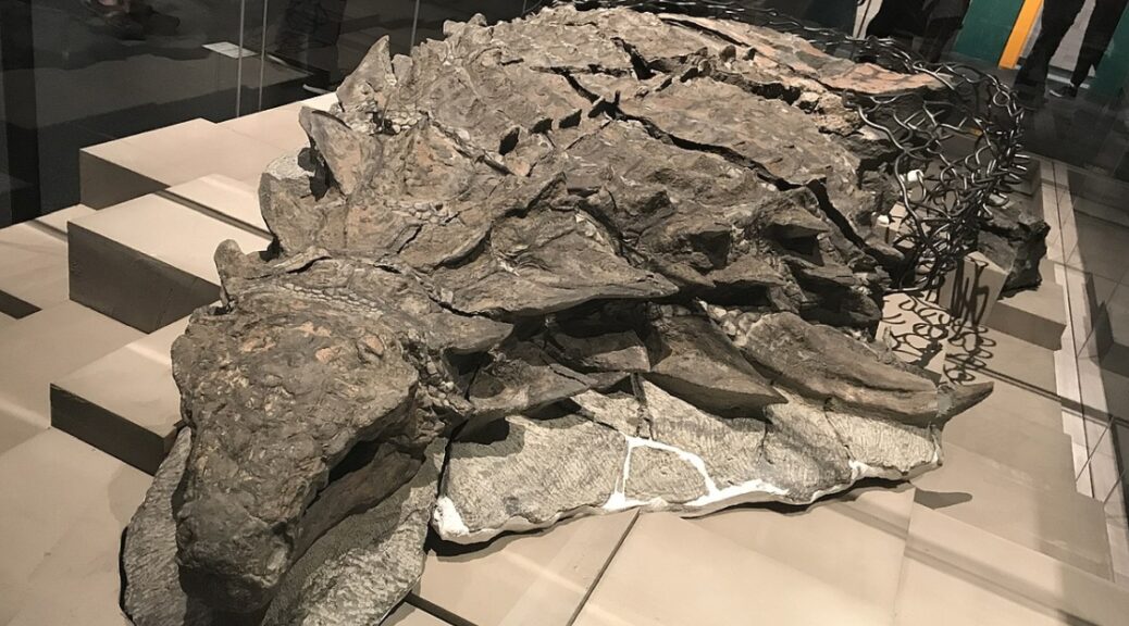
The Amazing Dinosaur Found (Accidentally) by Miners in Canada
This armored plant-eater lumbered through what is now Western Canada about 110 million years ago until a flooded river swept it into the open sea. The dinosaur’s undersea burial preserved its armor in exquisite detail. Its skull still bears tile-like plates and a gray patina of fossilized skins.
A heavy equipment mechanic named Shawn Funk cut his way through the earth in the afternoon of March 21, 2011, without knowing that he would encounter a dragon soon.
That Monday had started like any other at the Millennium Mine, a vast pit some 17 miles north of Fort McMurray, Alberta, operated by energy company Suncor.
Hour after hour Funk’s towering excavator gobbled its way down to sands laced with bitumen—the transmogrified remains of marine plants and creatures that lived and died more than 110 million years ago. It was the only ancient life he regularly saw. In 12 years of digging he had stumbled across fossilized wood and the occasional petrified tree stump, but never the remains of an animal—and certainly no dinosaurs.
But around 1:30, Funk’s bucket clipped something much harder than the surrounding rock. Oddly colored lumps tumbled out of the till sliding down onto the bank below. Within minutes Funk and his supervisor, Mike Gratton, began puzzling over the walnut brown rocks. Were they strips of fossilized wood, or were they ribs? And then they turned over one of the lumps and revealed a bizarre pattern: row after row of sandy brown disks, each ringed in gunmetal gray stone.
“Right away, Mike was like, ‘We gotta get this checked out,’ ” Funk said in a 2011 interview. “It was definitely nothing we had ever seen before.”
Stretched 18 feet long and weighed nearly 3,000 pounds. Researchers suspect it initially fossilized whole, but when it was found in 2011, only the front half, from the snout to the hips, was intact enough to recover. The specimen is the best fossil of a nodosaur ever found.
A cluster of pebble-like masses may be remnants of the nodosaur’s last meal.
Royal Tyrrell Museum technician Mark Mitchell slowly frees the nodosaur’s foot and scaly footpad from the surrounding rock. Mitchell’s careful work will preserve for years to come the animal’s enigmatic features.
Nearly six years later, I’m visiting the fossil prep lab at the Royal Tyrrell Museum in the windswept badlands of Alberta. The cavernous warehouse swells with the hum of ventilation and the buzz of technicians scraping rock from the bone with needle-tipped tools resembling miniature jackhammers. But my focus rests on a 2,500-pound mass of stone in the corner.
At first glance, the reassembled gray blocks look like a nine-foot-long sculpture of a dinosaur. A bony mosaic of armor coats its neck and back, and gray circles outline individual scales. Its neck gracefully curves to the left, as if reaching toward some tasty plant. But this is no lifelike sculpture. It’s an actual dinosaur, petrified from the snout to the hips.
The more I look at it, the more mind-boggling it becomes. Fossilized remnants of skin still cover the bumpy armor plates dotting the animal’s skull. Its right forefoot lies by its side, its five digits splayed upward. I can count the scales on its sole. Caleb Brown, a postdoctoral researcher at the museum, grins at my astonishment. “We don’t just have a skeleton,” he tells me later. “We have a dinosaur as it would have been.”
During its burial at sea, the nodosaur settled onto its back, pressing the dinosaur’s skeleton into the armor and embossing it with the outlines of some bones. One ripple in the armor traces the animal’s right shoulder blade.
Paleobiologist Jakob Vinther, an expert on animal coloration from the U.K.’s University of Bristol, has studied some of the world’s best fossils for signs of the pigment melanin. But after four days of working on this one—delicately scraping off samples smaller than flecks of grated Parmesan—even he is astounded. The dinosaur is so well preserved that it “might have been walking around a couple of weeks ago,” Vinther says. “I’ve never seen anything like this.”
Shielded from Decayarmored dinosaurs’ trademark plates usually scattered early in decay, a fate that didn’t befall this nodosaur. The remarkably preserved armor will deepen scientists’ understanding of what nodosaurs looked like and how they moved.
“That was a really exciting discovery,” says Victoria Arbour, an armoured-dinosaur palaeontologist at Canada’s Royal Ontario Museum. Arbour has seen the fossil at various stages of preparation, but she’s not involved in its study. “It represents such a different environment from today and such a different time, and it has great preservation.” (Arbour has begun studying a similarly well-preserved ankylosaur found in Montana in 2014, much of which remains hidden within a 35,000-pound block of stone.
Arbour and her colleague David Evans published a description of the Montana ankylosaur, naming it Zuul crurivastator—”Zuul, destroyer of shins”—after the monster in the film Ghostbusters.)
A lucky break in the nodosaur’s left shoulder spike reveals a cross-section of its bony core. The spike’s tip was sheathed in keratin, the same material that’s in human fingernails.
The afterword of the discovery raced up the ladder at Suncor, the company quickly notified the Royal Tyrrell Museum. Henderson and Darren Tanke, one of the museum’s veteran technicians, scrambled aboard a Suncor jet and flew to Fort McMurray. Suncor excavators and museum staff chipped away at the rock in 12-hour shifts, shrouded in dust and diesel fumes.
They eventually whittled it down to a 15,000-pound rock containing the dinosaur, ready to be hoisted out of the pit. But with cameras rolling, disaster struck: As it was lifted, the rock shattered, cleaving the dinosaur into several chunks. The fossil’s partially mineralized, cakelike interior simply couldn’t support its own weight.
Tanke spent the night devising a plan to save the fossil. The next morning Suncor personnel wrapped the fragments in plaster of Paris, while Tanke and Henderson scrounged for anything to stabilize the fossil on the long drive to the museum. In lieu of timbers, the crew used plaster-soaked burlap rolled up like logs.
The MacGyver-like plan worked. Some 420 miles later the team reached the Royal Tyrrell Museum’s prep lab, where the blocks were entrusted to fossil preparator Mark Mitchell. His work on the nodosaur has required a sculptor’s touch: For more than 7,000 hours over the past five years, Mitchell has slowly exposed the fossil’s skin and bone. The painstaking process is like freeing compressed talcum powder from concrete. “You almost have to fight for every millimeter,” he says.
Mitchells fight is nearly over, but it will take years, if not decades, to fully understand the fossil he uncovers. Its skeleton, for example, remains mostly obscured in skin and armor. In some ways it’s almost too well preserved; reaching the dinosaur’s bones would require destroying its outer layers. CT scans funded by the National Geographic Society have revealed little, as the rock remains stubbornly opaque.
In May the Royal Tyrrell Museum unveils the nodosaur as the centerpiece of a new exhibit of fossils recovered from Alberta’s industrial sites. Now the public is marveling at what has wowed scientists for the past six years: an ambassador from Canada’s distant past, found in a moonscape by a man with an excavator.
Archaeologists Have a Lot of Dates Wrong for North American Indigenous History — But Are Using New Techniques to Get It Right
It was in 1492 that Columbus reached the Americas. Many Europeans had travelled before, but the century from then until 1609 marks the creation of the modern globalized world.
It gave Europe extraordinary wealth and genocide and disease to indigenous peoples across the Americas.
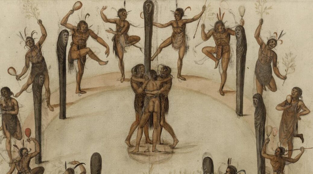
The dates and the estimates of the settlement in Europe are known from texts and sometimes illustrations, to use the failed colony on what was then Virginia’s Roanoke Island as an example.
However, one thing is missing. What of indigenous history in this traumatic era? Until now, the standard timeline has derived, inevitably, from the European conquerors, even when scholars try to present an indigenous perspective.
This all happened just 400 to 500 years ago – how wrong could the conventional chronology for indigenous settlements be? Quite wrong, it turns out, based on radiocarbon dating my collaborators and I have carried out at a number of Iroquoian sites in Ontario and New York state. We’re challenging existing – and rather colonialist – assumptions and mapping out the correct time frames for when indigenous people were active in these places.
Dating Iroquoia project member Samantha Sanft excavating at White Springs, New York.
Refining Dates Based on European Goods
Archaeologists estimate when a given indigenous settlement was active based on the absence or presence of certain types of European trade goods, such as metal and glass beads. It was always approximate, but became the conventional history.
Since the first known commercial fur trading missions were in the 1580s, archaeologists date initial regular appearances of scattered European goods to 1580-1600. They call these two decades Glass Bead Period 1. We know some trade occurred before that, though, since indigenous people Cartier met in the 1530s had previously encountered Europeans, and were ready to trade with him.
Archaeologists set Glass Bead Period 2 from 1600-1630. During this time, new types of glass beads and finished metal goods were introduced, and trade was more frequent. The logic of dating based on the absence or presence of these goods would make sense if all communities had equal access to, and desire to have, such items. But these key assumptions have not been proven.
16th-century European copper alloy beads from two sites in the Mohawk Valley.
That’s why the Dating Iroquoia Project exists. Made up of researchers here at Cornell University, the University of Georgia, and the New York State Museum, we’ve used radiocarbon dating and statistical modeling to date organic materials directly associated with Iroquoian sites in New York’s Mohawk Valley and Ontario in Canada.
First we looked at two sites in Ontario: Warminster and Ball. Both are long argued to have had direct connections with Europeans. For instance, Samuel de Champlain likely stayed at the Warminster site in 1615-1616. Archaeologists have found large numbers of trade goods at both sites.
Centuries-old maize sample, ready to be radiocarbon dated.
When my colleagues and I examined and radiocarbon dated plant remains (maize, bean, plum) and a wooden post, the calendar ages we came up with are entirely consistent with historical estimates and the glass bead chronology. The three dating methods agreed, placing Ball circa 1565-1590 and Warminster circa 1590-1620.
However, the picture was quite different at several other major Iroquois sites that lack such close European connections. Our radiocarbon tests came up with substantially different date ranges compared with previous estimates that were based on the presence or absence of various European goods.
For example, the Jean-Baptiste Lainé, or Mantle, site northeast of Toronto is currently the largest and most complex Iroquoian village excavated in Ontario. Excavated between 2003–2005, archaeologists dated the site to 1500–1530 because it lacks most trade goods and had just three European-source metal objects. But our radiocarbon dating now places it between about 1586 and 1623, most likely 1599-1614. That means previous dates were off the mark by as much as 50 to 100 years.
Other sites belonging to this same ancestral Wendat community are also more recent than previously assumed. For example, a site called Draper was conventionally dated to the second half of the 1400s, but radiocarbon dating places it at least 50 years later, between 1521 and 1557. Several other Ontario Iroquoian sites lacking large trade good assemblages vary by several decades to around 50 years or so from conventional dates based on our work.
Sturt Manning examining a sample in the Cornell Tree Ring Laboratory.
My colleagues and I have also investigated a number of sites in the Mohawk Valley, in New York state. During the 16th and early 17th centuries, the Mohawk and Hudson Rivers formed a key transport route from the Atlantic coast inland for Europeans and their trade goods. Again, we found that radiocarbon dating casts doubt on the conventional time frame attributed to a number of sites in the area.
Biases That Led to Misguided Timelines
Why were some of the previous chronology wrong?
The answer seems to be that scholars viewed the topic through a pervasive colonial lens. Researchers mistakenly assumed that trade goods were equally available, and desired, all over the region, and considered all indigenous groups as the same. On the contrary, it was Wendat custom, for example, that the lineage whose members first discovered a trade route claimed rights to it. Such “ownership” could be a source of power and status. Thus it would make sense to see uneven distributions of certain trade goods, as mediated by the controlling groups. Some people were “in,” with access, and others may have been “out.”
Ethnohistoric records indicate cases of indigenous groups rejecting contact with Europeans and their goods. For example, Jesuit missionaries described an entire village no longer using French kettles because the foreigners and their goods were blamed for disease.
There are other reasons European goods do or do not show up in the archaeological record. How near or far a place was from transport routes, and local politics, both within and between groups, could play a role. Whether Europeans made direct contact, or there were only indirect links, could affect availability. Objects used and kept in settlements could also vary from those intentionally buried in cemeteries. Above all, the majority of sites are only partly investigated at best, some are as yet unknown. And sadly the archaeological record is affected by the looting and destruction of sites. Only a direct dating approach removes the Eurocentric and historical lens, allowing an independent time frame for sites and past narratives.
Dating Iroquoia Project member Megan Conger excavating at White Springs, New York. Some locations have been under-explored, so far, by archaeologists.
Effects of Re-dating Indigenous History
Apart from changing the dates for textbooks and museum displays, the re-dating of a number of Iroquoian sites raises major questions about the social, political and economic history of indigenous communities. For example, conventionally, researchers place the start of a shift to larger and fortified communities, and evidence of increased conflict, in the mid-15th century.
However, our radiocarbon dates find that some of the key sites are from a century later, dating from the mid-16th to start of the 17th centuries. The timing raises questions of whether and how early contacts with Europeans did or did not play a role. This period was also during the peak of what’s called the Little Ice Age, perhaps indicating the changes in indigenous settlements have some association with climate challenge.
Our new radiocarbon dates indicate the correct time frame; they pose, but do not answer, many other remaining questions.