Volunteers Spot Iron Age Hillfort in Southern England
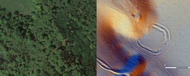
According to a BBC News report, volunteers with the Beacons of the Past project identified the possible site of an Iron Age hillfort covered with trees and foliage in lidar images of the southern Chiltern Hills, a chalk escarpment stretching 45 miles across southern England.
From digital survey images, last year and the hillfort was verified on 6 August. It is thought the circular site dates from the early Iron Age in England, between 800BC and 500BC.
Work will take place to preserve the site.
Dr Ed Peveler pictured by the iron age hillfort in the southern Chiltern Hills
The remains of the hillfort include a 9m-wide (30ft) bank and an external ditch that is 7m (23ft) wide.
Its perimeter is more than 500m (1,640ft) in length and it is thought it would have covered 7.5 acres (3 hectares).
Despite the name, hillforts are often neither on a hill nor used as forts. Archaeologists believe they may have been used as defended settlements, production sites, or stock enclosures.
The new site in the southern Chilterns was first identified through images from a large scale LiDAR scan of the area. LiDAR technology can penetrate foliage that might hide archaeological sites, using laser pulses.
Beacons of the Past’s trained volunteers, known as “citizen scientists”, helped look through LiDAR data to help identify sites.
The exact location of the hillfort has not been disclosed to protect the site and the landowner’s privacy.
An example of LiDAR technology identifying a different hillfort in the Chiltern Hills.
Work will take place to preserve what remains of the hillfort, but there are no plans to excavate the site at present.
Project manager and archaeologist Dr Wendy Morrison said: “Although one can never be certain of the age of a prehistoric earthwork without excavating for dating evidence, visual inspection of the rampart and ditch, paired with its location, dominating views in the landscape, give me the confidence to say this is very likely to be an Early Iron Age univallate hillfort.”
Beacons of the Past is a National Lottery Heritage Fund project hosted by the Chilterns Conservation Board.
Yarm Viking helmet ‘first’ to be unearthed in Britain
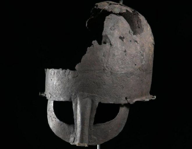
According to new research, a Viking helmet discovered at Teesside is the first ever to be found in Britain. In the 1950s, in Chapel Yard, Yarm, a corroded helmet was unearthed by workmen digging trenches for new sewerage pipes.
The ‘Viking helmet’, as it is known locally, has been on loan to Preston Park Museum from Yarm Town Council for a number of decades. A research project, led by Dr. Chris Caple, has now discovered that the helmet is the first ever found in Britain.
It is also only the second nearly complete Viking helmet found in the world. The unusual artifact has never previously been researched and the age of the helmet had caused much debate.
In recent years, Dr. Caple, Emeritus Reader at Durham University, and his colleagues have discovered new information about the damaged helmet.
They used evidence from recent archaeological discoveries as well as analysis of the metal and corrosion to identifying that it is an Anglo-Scandinavian helmet made in the 10 century in northern England.
Dr. Caple said it was a “challenging project” as the thin iron sheet is now very susceptible to corrosion and has to be kept in very dry conditions.
He said: “Our analysis showed that it was initially preserved in waterlogged conditions, only later becoming damaged and starting to corrode. Fortunately, it was discovered before it corroded away completely.
“Although there are half a dozen early medieval helmets from Britain, the Sutton Hoo, and Coppergate helmets being the most famous, this is the first Anglo-Scandinavian (Viking) helmet from Britain.
“Whilst the Saxon helmets were often highly decorated and were worn by warrior leaders, as many symbols of authority as helmets, by the 10 century we can now envisage that most professional warriors had helmets like the Yarm Helmet.
The helmet is made of iron bands and plates riveted together, with a simple knop at the top
“They were simply manufactured, well designed to protect the wearer (rivets flush with the surface so they did not catch bladed weapons) but no longer decorated.
“Together with a mail hauberk (shirt of chain mail), a helmet was essential personal protective equipment for a warrior. We see almost all the combatants in the 11 century Bayeux Tapestry wearing helmets and hauberks.”
Dr. Caple said that the only other near-complete Viking helmet is from Gjermundbu in Norway.
He said: “They do not normally survive because by the 10th century both Anglo-Scandinavian and Saxons were Christian and no longer buried objects in graves.
“This helmet, like the Coppergate helmet appears to have been hidden in a pit.”
Alan Gallafant, Chairman of Yarm Town Council, said: “Yarm Town Council are delighted that the provenance of this important historic helmet has been confirmed, thanks to the work carried out by Dr. Chris Caple and Durham University.
“Yarm Town Council welcomes the launch of this exciting development on Yarm’s history.”
The Yarm Helmet has been on permanent display at Preston Park Museum since 2012, where its condition is closely monitored and it continues to be one of the star objects on display.
The helmet has been on loan to Preston Park Museum from Yarm Town Council
Councillor Jim Beall, Stockton-on-Tees Borough Council’s Cabinet Member for Health, Leisure, and Culture, added: “It’s very exciting to have confirmation that the Yarm Helmet on display at Preston Park Museum is a very rare example of a Viking helmet and the first to be found in Britain.
“The museum is open to the public once again and it is great to welcome visitors to see this fascinating piece of history.”
Textile treasure trove shows Importance of fashion to Ancient Britons
Notable archeological evidence from the site of a prehistoric settlement in the eastern part of England, suggests that Bronze Age Britons had a liking for high-end fashion. Excavations, 30 miles north-west of Cambridge, have unearthed the earliest examples of superfine textiles ever found in Britain. They are also among the most finely-made Bronze Age fabrics ever discovered in Europe as a whole – and are of huge international significance.
Detail of preserved Bronze Age textile made from plant fibres
Up to now, researchers from the University of Cambridge have found more than 100 fragments of textile unspun processed fibre and textile yarn at the site. Some of the yarn is of superfine quality – with some threads being just 100 microns (1/10 of a millimetre) in diameter, while some of the fabrics themselves are so finely woven that they have 28 threads per centimetre, fine even by modern standards. It’s likely that some of the fragments of textile are from items of clothing.
Originally, some of the textiles must have been of very substantial size – because they had been folded, in some cases in up to 10 layers. If made to be worn, these folded fabrics may well have been large garments, potentially, capes, cloaks – or even large drapes, perhaps similar to those known from elsewhere in the ancient (and sometimes modern) worlds – the ancient Greek chiton, the Roman toga and the Indian sari. A drape folded into 10 layers for temporary storage would have served as a substantial garment – potentially up to 3 metres square (i.e. 9 square metre).
Most of the superfine fabrics from the site – Must Farm near Whittlesea, Cambridgeshire – were made of linen. When the village was flourishing around 3,000 years ago, textile manufacture seems to have been a key craft practiced there. Hundreds – possibly thousands – of flax seeds have so far been found on the site (some of which had been stored in containers). Flax is the crop that produces the fibres used in linen production.
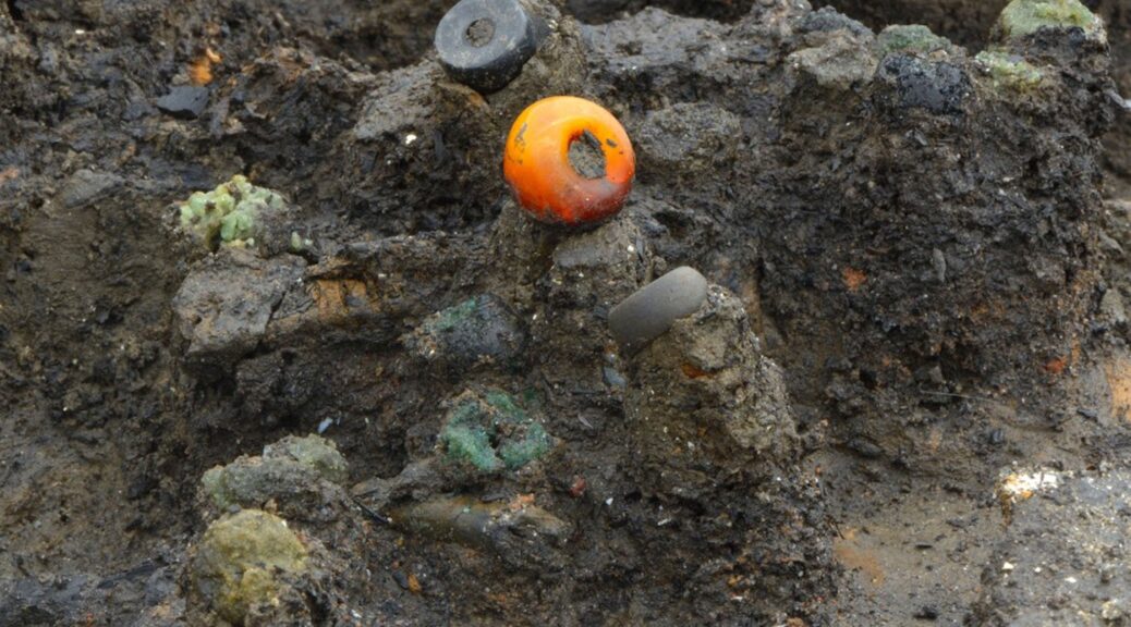
Amber bead and others found in situ
What’s more, the presence on the site of unspun processed fibre, yarn, and finished textiles all strongly suggests that the village was involved not only in using textiles but also in manufacturing them. Timber fragments with delicate carpentry, found during the Historic-England-funded excavation may well be the remains of looms. Indeed fired clay loom weights have been unearthed there.
The archaeologists have also discovered that Bronze Age Britons also had a penchant for a different type of fabric – made of processed nettle stems (from a locally available non-stinging subspecies of nettle – today known as fen nettles). Unlike flax, nettles grew wild and therefore did not need to be cultivated. What’s more, well-made nettle textile was often particularly fine and silky.
But nettles may well have had additional benefits – at least in the eyes of the users of the fabrics.
In traditional ancient folklore, nettles of various types were often regarded as having magical powers. They were seen as being able to protect both humans and animals from sorcery and witchcraft. What’s more, garments made of nettles were therefore sometimes seen as protecting their wearers from evil. Indeed one of Europe’s most famous folktales – the Wild Swans (written by Hans Christian Andersen, but thought to be based on traditional folk stories) – reveals how shirts, made of nettle yarn, enabled their wearers to break a witch’s spell.
So far no evidence of any extensive patterns or coloured dyes have been found on any of the linen and nettle yarn textile fragments – although the edge of one piece of fabric (perhaps part of a shawl or cape) seems to have been decorated with fringes, rows of knots, and strips featuring different styles of weave. Certainly, dying the linen would have presented substantial technical difficulties – but bleaching it would have been much less challenging. It is therefore very likely that the naturally light brown linen was bleached to achieve a creamy white or possibly even dazzlingly pure white appearance. Basic bleaching of the fabric might well have been achieved with the use of a mixture of urine and milk or by simply laying out the fabrics on wet grass on a succession of sunny days. The village appears to have been very prosperous, yet tragically short-lived.
As well as making (and presumably using) ultra-fine fabrics, at least some of the inhabitants wore exotic jewellery made of blue, black, yellow and green glass manufactured in the eastern Mediterranean region – probably in what is now the Syria or Turkey.
They lived in large well-built houses and had a wide range of tools and other possessions. So far, around 50 bronze axes, sickles, spears, swords, razors, hammers, tweezers, and awls have been found along with some 60 wooden buckets, platters, and troughs as well as around 60 well preserved ceramic bowls, mugs and storage jars. Dug-out canoes and two wooden wheels have also been unearthed.
But the archaeological evidence suggests that this thriving and prosperous settlement was probably attacked, burnt, and destroyed by its enemies less than a year after it was built.
In the five houses excavated so far, the population seems to have fled or been captured or killed, leaving all their possessions behind – meals half eaten, salted or dried meat still hanging in the rafters, garments neatly folded on or around well-made wooden furniture.
“It’s a bit like discovering the Marie Celeste. Everything is exactly as it was left. Only the inhabitants are missing,” said the director of the excavation, Mark Knight of the Cambridge Archaeological Unit.
“This site is providing the modern world with an image of daily life in the British Bronze Age that was until now beyond our dreams. It is only the very specific and unusual circumstances of the destruction of the settlement that has, paradoxically, allowed so much of it to be preserved intact,” he said.
Because the village had been set alight, large numbers of wooden, textile and other artefacts were charred – and because the houses were built on wooden stilts in a river (flanked by marchland), everything ultimately ended up underwater, where it was subsequently covered with silt and mud.
This rare combination of charring and waterlogging and natural burial under sediment has been responsible for the extraordinarily high levels of preservation.
Most of the artefacts have been found inside the settlement’s houses. So far, five of these large 6-8 metre diameter structures have been found at the site. Again, because of charring and subsequent waterlogging, around half of all the wall, roof and other timbers from these buildings have been preserved.
The excavation is being directed by archaeologist Mark Knight of the Cambridge Archaeological Unit, with textile research being carried out by a textile specialist, Dr Susanna Harris of the University of Glasgow. Because of its national and international importance, the entire project is being funded to the tune of £1.4 million by Historic England and the owner of the site, one of the UK’s major brick-making companies – Forterra.
The finds include the largest group of prehistoric textiles ever discovered in Britain – and the largest collection of complete bronze, wooden and ceramic artefacts ever found in a British Bronze Age settlement.
Bizarre French inspiration of Stonehenge as slab origins confirmed
Some experts believe that the ancient monument was used as a cemetery for more than 500 years, and some suggest that it may be of spiritual importance, due to the encompassing horseshoe arrangement being aligned to the sunset of the winter solstice and the opposing sunrise of the summer solstice.
Up until now, all that archaeologists knew with reasonable certainty was that the stones had been brought in around 2500BC from the Marlborough Downs by the great temple’s Neolithic builders.
Now though, scientists from the University of Brighton have traced the stones to a very specific two square mile part of that range of hills — a patch of woodland just south of the village of Lockeridge, Wiltshire.
But, they may have taken inspiration from overseas.
A study published in the journal Proceedings of the National Academy of Sciences suggests an ancient culture that emerged from what is now the Brittany region of northwest France may have begun building these structures and monuments some 7,000 years ago.
Archaeologists believe Stonehenge builders took inspiration from France
Study author Bettina Schulz Paulsson of the University of Gothenburg in Sweden said that the megalith building probably began in France and spread from there via sea routes around Europe over the next 1,000 years or so.
For more than a decade, Dr. Paulson created a “megalith evolution” using radiocarbon dating of more than 2,000 historic sites across Europe.
She wrote: “The results presented here, based on analysis of 2,410 radiocarbon dates and highly precise chronologies for megalithic sites and related contexts, suggest maritime mobility and intercultural exchange.
“We argue for the transfer of the megalithic concept over sea routes emanating from northwest France, and for advanced maritime technology and seafaring in the megalithic Age.”
These structures were originally thought to have their roots in Northern Europe, but Dr. Paulsson has long suspected they originated elsewhere since she excavated her first megalithic site approximately 20 years ago, in Portugal.
She added: “Everyone told me ‘you’re crazy, it can’t be done, but I decided to do it anyway.”
Michael Parker Pearson, an archaeologist, and Stonehenge specialist at University College London said: “This demonstrates absolutely that Brittany is the origin of the European megalithic phenomenon.”
One of the most famous landmarks in the United Kingdom, Stonehenge is regarded as a British cultural icon. It has been a legally protected Scheduled Ancient Monument since 1882 when legislation to protect historic monuments was first successfully introduced in Britain.
Stonehenge is owned by the Crown and managed by English Heritage, the surrounding land is owned by the National Trust.
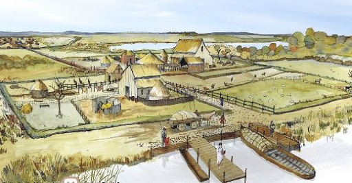
North sea reveals forest buried for 7,000 years and human footprints
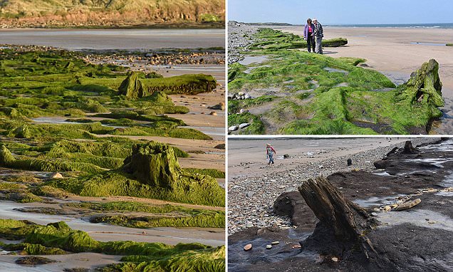
The surge and flood of the North Sea have uncovered an archeological mystery of the Britain past – the remains of hunter-gatherers chasing wildlife through a long-lost wood. An ancient woodland, dating more than 7,000 years and submerged under the sand for centuries, is slowly uncovered by the ocean.
The North Sea has eroded the shore of a Northumberland beach to reveal the remnants of an ancient forest dating back 7,000 years. Archaeologists believe the preserved tree stumps and felled tree trunks lining a 200-meter stretch of coastline south of Amble would have stretched to Europe before the water mass formed
Tree stumps and felled logs, which have been preserved by peat and sand, are now clearly visible along with a 650 feet (200 meters) stretch of coastline at Low Hauxley near Amble, Northumberland.
Studies of the ancient forest, which existed at a time when the sea level was much lower and Britain had only recently separated from what is now mainland Denmark, have revealed it would have consisted of oak, hazel and alder trees.
The forest first began to form around 5,300 BC but by 5,000 BC the encroaching ocean had covered it up and buried it under the sand. Now the sea levels are rising again, the remnants of the forest are becoming visible and being studied by archaeologists.
Rather than a continuous solid landmass, archaeologists believe Doggerland was a region of low-lying bogs and marshes that would have been home to a range of animals, as well as the hunter-gatherers which stalked them.
But the relatively rapid change in the surrounding environment would have gradually confined animals and humans in the region to Europe and the UK as the bogs and marshes became flooded, making them impassable.
Doctor Clive Waddington, of Archaeology Research Services, said: ‘In 5,000 BC the sea level rose quickly and it drowned the land. The sand dunes were blown back further into the land, burying the forest, and then the sea receded a little.
Among the remnants of the ancient forest are tree stumps jutting out of the beach, which have been preserved in a layer of peat
The sea level is now rising again, cutting back the sand dunes, and uncovering the forest. The forest existed in the late Mesolithic period, which was a time of hunting and gathering for humans.
In addition to tree stumps, archaeologists say they have uncovered animal footprints, highlighting the diverse wildlife which would have roamed the ancient Doggerland forest.
Dr. Waddington, who says evidence has been discovered of humans living nearby in 5,000 BC, added: ‘On the surface of the peat we have found footprints of adults and children.
‘We can tell by the shapes of the footprints that they would have been wearing leather shoes.
‘We have also found animal footprints of red deer, wild boar, and brown bears.’
A similar stretch of ancient forest was uncovered in 2014 near the village of Borth, Ceredigion, in Mid Wales after a spate of winter storms washed away the peat preserving the area.
Rather than a continuous solid landmass, archaeologists believe Doggerland was a region of low-lying bogs and marshes connecting the British Isles to Europe and stretching all the way to the Norwegian trench (pictured left). The area, which would have been home to a range of animals, as well as the hunter-gatherers which stalked them, became flooded due to glacial melt, with some high-lying regions such as ‘Dogger Island’ (pictured right, highlighted red) serving as clues to the regions ancient past
Peat is able to preserve trees and even the bodies of animals so well because it is so low in oxygen, effectively choking the microbes which break down organic matter, so preserving their organic contents for thousands of years.
But in coastal regions where ancient forests have been long preserved in peat, such as in Wales and Northumberland, the rising seas are washing away this layer and exposing remnants from Britain’s past.
The uncovered forest has drawn interest from members of the public walking along the coast as they stop to inspect the preserved trees
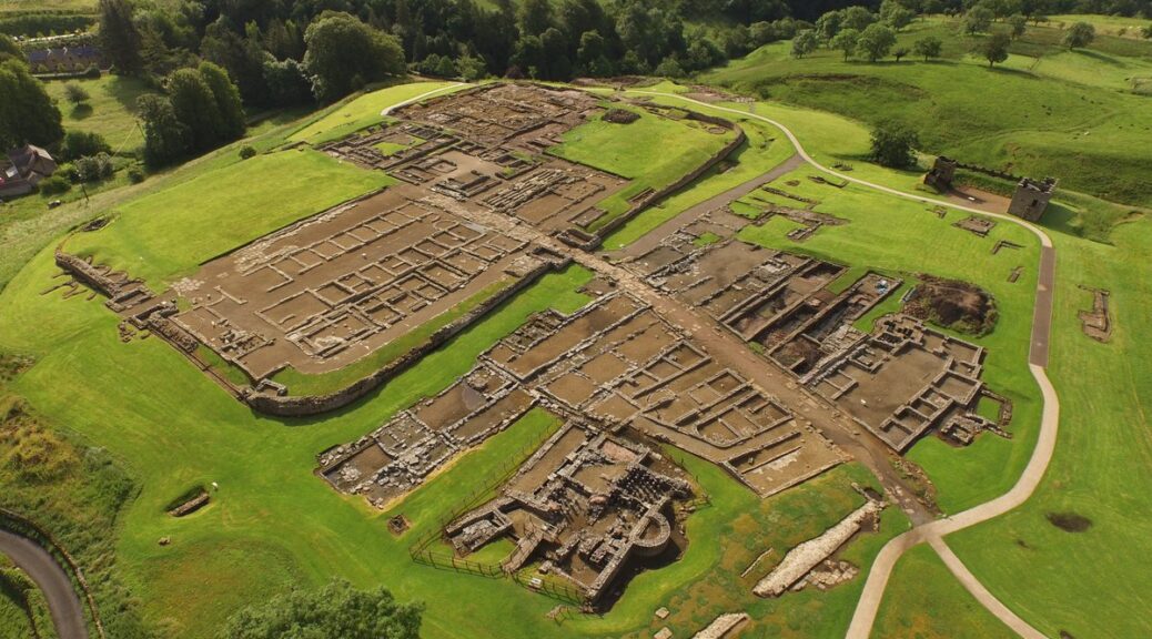
Burscough, England —Ansa reports that the site of a first-century A.D. Roman fort in northwestern England has received official recognition from Historic England, a government body dedicated to historic preservation.
A Roman fort lies underneath land off Flax Lane, Burscough
The ruins comprise a 30,000 sq m fort, roads, and a smaller fortlet and experts believe the find will unlock unknown details of how the Romans settled and travelled around the area.
Considered alongside other forts in the region, including those at Wigan and Ribchester, Burscough’s will provide great insight into Roman military strategy. It is believed that the area was occupied multiple times over the course of hundreds of years, a theory that is backed up by the variety of pottery found at the site.
Historic England says the lines of the fort’s defences are clearly identifiable on the geophysical survey and aerial photos, but the north-west and south-west corners are also visible as slight earthworks on Lidar, which uses laser light reflections to produce 3D images.
The north-west corner of the fort is visible as the slight earthwork of a broad bank about 12m wide, with a regular, broad and shallow external ditch; the latter is interpreted as a shallow quarry ditch dug during the construction of the rampart.
Several large depressions visible in the wider landscape are considered to be post-medieval extraction, probably marl pits: one of these pits sits within the angle of the north-west corner of the fort.
The number of ditches is considered to indicate more than one phase of occupation, and it is considered that a later, small fortlet overlies the eastern rampart of the earlier fort.
A number of internal features have been revealed by geophysical surveys including a well-defined eastern gateway with double gate towers, and numerous stone buildings interpreted as granaries or barracks. Limited trial trenching of the latter has revealed the presence of a large stone, buttressed building typical of a Roman granary.
The geophysical survey has also revealed the buried remains of a broad section of Roman road approaching the fort on the east side. A similar feature is thought to be associated with the fort’s southern entrance.
For several years, a non-profit archaeology group has been managing the site and allowing people to help with the excavation of the ruins but the location of the fort has largely been kept a secret.
Those interested in visiting were able to pay to take part in organized digs, while items of Roman pottery have been found in nearby fields by passing walkers.
The fort had survived regular ploughing through the years before the archaeology group took an interest in the site but concerned residents noticed diggers on the field in recent weeks and feared that the invaluable findings could be lost forever.
But, possibly partly as a result of those fears being raised with Historic England and then the Government’s Department for Culture, Media and Sport (DCMS), the ruins have now been classified as a Scheduled Monument.
That means it is a criminal offence to destroy or damage it; do any works to remove, repair or alter it; use a metal detector without prior consent, or remove any historic or archaeological object from the site without prior consent.
A spokesperson for Historic England said: “DCMS recently agreed with our advice that this site should be protected as a scheduled monument because it is a highly significant find of a Roman fort which has survived well.
‘‘We are actively in contact with the owners and local authority to offer advice and support on how best to manage this site to ensure its future.”
One of the discoveries of archeological work in Waterbeach Barracks was Roman pottery and coins, along with Bronze Age PalStave ax-head. Before work starts on the first phase of the new town development, Oxford Archaeology East has been working with developer Urban & Civic and Cambridgeshire County Council’s historic environment team at the site.
Comprehensive research was undertaken and three areas of Roman settlement, two areas of Roman industry and several parts of a medieval field system – called a ridge and a furrow – were uncovered
The land is at the junction of two important Roman regional transport links: the Car Dyke (Old Tillage) Roman canal which is one of the greatest engineering feats carried out by Romans in Britain – and the Roman road known as Akeman Street, which connects Ermine Street near Wimpole Hall and runs along the alignment of Mere Way joining the broad route of the A10 up to the north Norfolk coast.
Oxford Archaeology East working at the Waterbeach Barracks.
The archaeology team has been investigating the site since 2016, and following desk-based research and geographical surveys of the key areas, they have opened nearly 140 archaeological trial trenches across the entire site to explore what has survived the more recent agricultural and military uses.
Over the last few weeks, approximately seven hectares – the size of 10 football pitches – have been dug in the northern corner of the airfield, with early evaluation identifying a potential Roman settlement.
Having stripped the topsoil with excavators, the team was able to delve deeper with hand tools to explore and interpret the layers of history beneath. This included a complex system of ditches, dating to the latest Iron Age and early Roman period (about 2,000 years old) as well as a lot of artifacts: from Roman pottery and coins to an amazing Bronze Age palstave axe-head.
A number of pottery kilns were also found that would have produced pottery during the Roman period.
Oxford Archaeology East working at the Waterbeach Barracks.
Stephen Macaulay, deputy regional manager of Oxford Archaeology East, said: “Waterbeach Barracks is a fascinating site and the new development gives us a unique opportunity to capture the essence of its foundations and an understanding of how our ancestors lived and worked the land.
“The site is in a unique location and the historic role of Car Dyke and Akeman Street Roman road (the modern A10) and water connections need more celebration within Cambridgeshire. Hopefully, the approach at Waterbeach is the start of making that happen.”
Further archaeological excavations will take place in advance of each phase of development at Waterbeach. The first phase covers 1,600 homes, while 6,500 will be built in total on the site by Urban & Civic.
Rebecca Britton, of Urban & Civic, said: “Waterbeach Barracks is a historic place with rich layers of heritage that span millennia.
While the recent military past is something that we are all familiar with, this work enables us to dig deeper into the past, find out more about how our predecessors lived and what they did here.
“This is not only incredibly useful in informing our understanding of the past, but also provides a rich seam of inspiration for the future development: whether it’s street or park names, the design of public art, or part of connecting future residents with the history literally under their feet.
“History is a great way of establishing connections between people and is part of our wider commitment to working with Denny Abbey, the Tithe Barn at Landbeach, Wicken Fen, and other important local heritage assets to engage people with and celebrate the amazing history.”
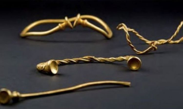
Researchers left ‘speechless’ by ‘magical’ Iron Age treasure
Archaeologists were stunned when they unearthed Iron Age treasure owned by extremely wealthy figures from the time period. The amazing discovery was made in 2016 as two treasure hunters – Mark Hambleton and Joe Kania – found the earliest example of Iron Age gold ever found in Britain.
The collection included four twisted metal neckbands, called torcs and a bracelet. Experts concluded the jewellery would have been owned by wealthy powerful women who probably moved from continental Europe to marry rich Iron Age chiefs.
Mr. Hambleton was also delighted when he and his partner were told the find could be worth hundreds of thousands of pounds. Mr. Hambleton said at the time: “We weren’t expecting to find anything. I was just about ready to give up for the day when Joe said he thought he had found something.
The jewellery was worth over £300,000
“We both looked at it and were speechless.”
Mr. Kania added: “We have found the odd Victorian coin, but mostly it has just been junk.
“So I couldn’t believe it when I picked out this mud-covered item and on cleaning it off, I thought this might actually be gold.”
Mr. Hambleton also told of how he slept with the jewellery before taking it to the Portable Antiquities Scheme at Birmingham.
He added: “I kept the gold right next to my bed to make sure it was safe until we could hand them into the experts.
“I used to go metal detecting with my dad when I was young and he said to me ‘why are you bothering fishing? You should be back in those fields.’
“I am so glad we took his advice and pleased, of course, that he got the chance to see these amazing pieces and prove he was right all along.”
Dr. Julia Farley, Curator of British & European Iron Age Collections for the British Museum lauded the find.
She said: “This unique find is of international importance.
“It dates to around 400–250 BC and is probably the earliest Iron Age gold work ever discovered in Britain.
“The torcs were probably worn by wealthy and powerful women, perhaps people from the continent who had married into the local community.
David Booth, metal detector enthusiast poses with his hoard of Iron Age Gold
The torcs were buried nested together and archaeologists believe they may have been buried for safekeeping. Others claimed they could have been buried as an offering to a God, or even as an act of remembrance for someone who had died.
The find was made about 45 miles north of Hammerwich, near Lichfield – the site of the 2009 Anglo-Saxon Staffordshire Hoard find, which was officially valued at £3.2 million.